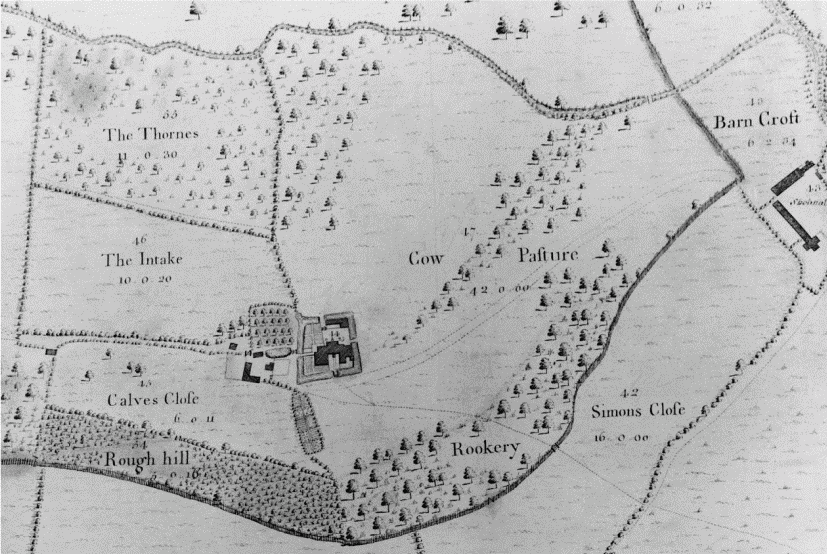
The Rough
Wood, Forest in Staffordshire East Staffordshire
England
The Rough

The Rough, Staffordshire, also known as Wood or Forest, is a picturesque area located in the county of Staffordshire, England. With its lush greenery, rolling hills, and diverse wildlife, it is a popular destination for nature lovers and outdoor enthusiasts.
Covering an area of approximately 500 acres, The Rough is characterized by its dense woodland, consisting mainly of oak, beech, and birch trees. These trees provide a habitat for a variety of animal species, including deer, foxes, badgers, and numerous bird species. It is not uncommon for visitors to catch a glimpse of these creatures as they explore the area.
The Rough offers numerous walking trails and paths, allowing visitors to fully immerse themselves in the beauty of the natural surroundings. There are also designated picnic areas and viewpoints that offer stunning vistas of the Staffordshire countryside.
For those interested in history, The Rough has a rich past dating back hundreds of years. It was once used as a hunting ground for nobles and is dotted with remnants of old hunting lodges and gamekeepers' cottages.
The area is managed by the local council, and there are strict regulations in place to preserve and protect the natural environment. Visitors are encouraged to respect these rules and take care not to disturb the wildlife or damage the flora.
Overall, The Rough, Staffordshire is a haven for nature enthusiasts, offering a peaceful and serene setting for exploration and relaxation. Whether it's a leisurely stroll through the woodland or a picnic overlooking the rolling hills, visitors are sure to be captivated by the beauty of this enchanting location.
If you have any feedback on the listing, please let us know in the comments section below.
The Rough Images
Images are sourced within 2km of 52.802871/-1.6757098 or Grid Reference SK2122. Thanks to Geograph Open Source API. All images are credited.


The Rough is located at Grid Ref: SK2122 (Lat: 52.802871, Lng: -1.6757098)
Administrative County: Staffordshire
District: East Staffordshire
Police Authority: Staffordshire
What 3 Words
///shapeless.debate.juror. Near Burton upon Trent, Staffordshire
Nearby Locations
Related Wikis
Sinai Park House
Sinai Park House is a grade II* listed building in Burton upon Trent, Staffordshire, England. Consisting of a central range with two wings the building...

Shobnall
Shobnall is a settlement and civil parish located in Staffordshire, England. It covers an area located in the west of Burton upon Trent. The population...

St Saviour's Church, Branston
Saint Saviour's is the Church of England parish church for the village of Branston, south of Burton upon Trent. It is part of the Diocese of Lichfield...

Tatenhill
Tatenhill is an ancient village and a civil parish located in a deep valley, between two hills, which gradually descend from the eastern border of Needwood...

Branston railway station
Branston railway station was a railway station serving the village of Branston in Staffordshire. == History == In 1887 local residents began to petition...

Anglesey, Staffordshire
Anglesey is a civil parish in the East Staffordshire district of Staffordshire, England. It covers an area in the south of Burton upon Trent, south of...
St Paul's, Burton upon Trent
St Paul's Church is a Church of England parish church in Burton upon Trent, Staffordshire England. The church, on St Paul's Square and near the Town Hall...

Branston Depot
Branston Depot is a former ordnance facility at Branston, Staffordshire. == History == The site was originally conceived as the National Machine Gun Factory...
Nearby Amenities
Located within 500m of 52.802871,-1.6757098Have you been to The Rough?
Leave your review of The Rough below (or comments, questions and feedback).