Beck Meetings Plantation

Wood, Forest in Yorkshire Harrogate

England

Beck Meetings Plantation

Kirk Bank Minor lane heading west from Kirkby Malzeard.
Kirk Bank Credit: Chris Heaton

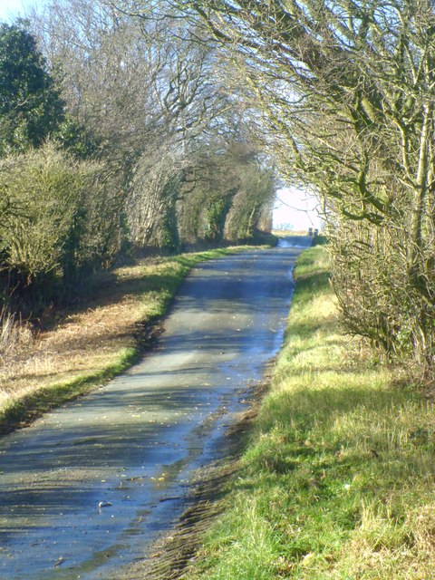
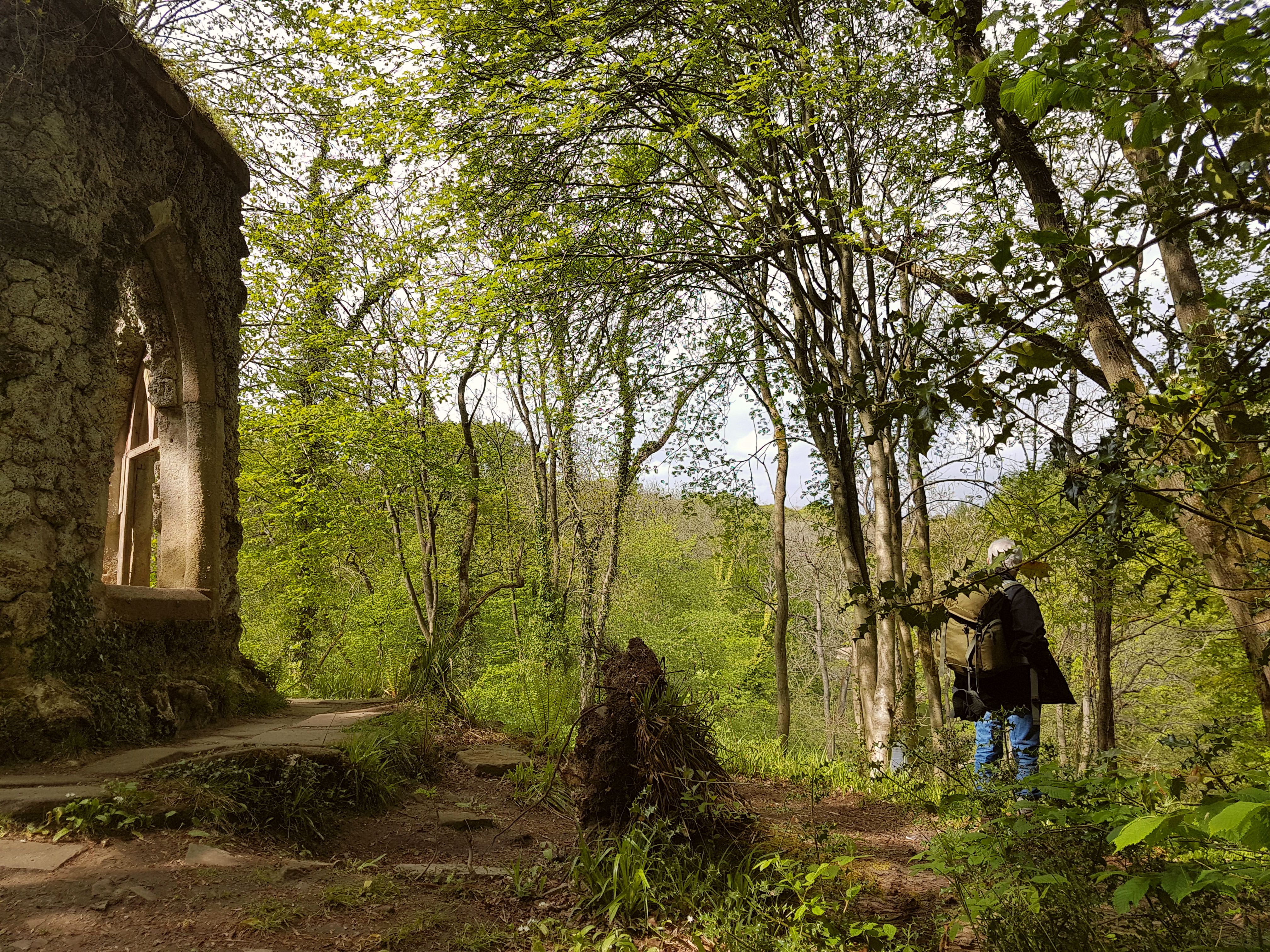
Beck Meetings Plantation, located in Yorkshire, England, is a captivating woodland area known for its lush greenery and natural beauty. Spanning over a vast expanse, this plantation is a perfect retreat for nature enthusiasts and those seeking tranquility away from the bustling city life.

The plantation is predominantly composed of dense woodlands and forests, creating a serene environment that is home to a diverse range of flora and fauna. Tall, majestic trees, such as oak, beech, and birch, dominate the landscape, providing a canopy that filters sunlight and casts dappled shadows on the forest floor. The undergrowth is abundant with ferns, wildflowers, and mosses, adding vibrant colors and textures to the area.

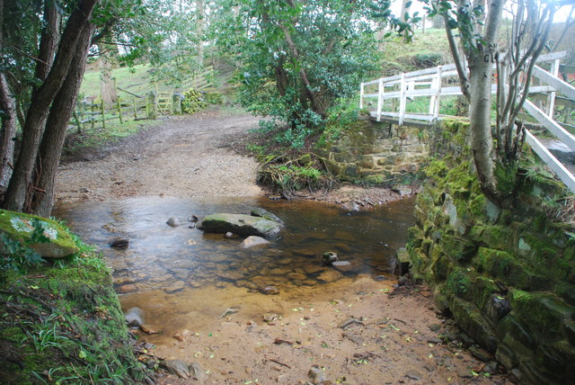
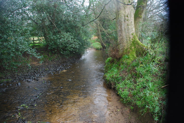
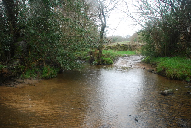
A winding beck, or stream, meanders through the plantation, adding to its allure. The gentle sound of running water creates a soothing ambiance, attracting various wildlife species, including birds, rabbits, and deer. Birdwatchers will be delighted to spot rare species like woodpeckers, owls, and thrushes, which find solace amidst the woodland's tranquility.

Beck Meetings Plantation offers a range of recreational activities for visitors to enjoy. Hiking trails, well-maintained and marked, allow nature lovers to explore the plantation's wonders at their own pace. Picnic areas are scattered throughout the woodland, providing a perfect spot to relax and soak in the beauty of the surroundings.

This charming plantation in Yorkshire truly encapsulates the essence of a serene, picturesque woodland. Its natural beauty, diverse wildlife, and peaceful atmosphere make it an ideal destination for those seeking respite in nature.

If you have any feedback on the listing, please let us know in the comments section below.

Beck Meetings Plantation Images

Images are sourced within 2km of 54.156256/-1.6751692 or Grid Reference SE2173. Thanks to Geograph Open Source API. All images are credited.

Kirk Bank Minor lane heading west from Kirkby Malzeard.
Kirk Bank
Minor lane heading west from Kirkby Malzeard.
Road Junction, Kirkby Malzeard Road junction at the western end of Kirkby Malzeard village.
Road Junction, Kirkby Malzeard
Road junction at the western end of Kirkby Malzeard village.
Entering Kirkby Malzeard Entering the village from Laverton.
Entering Kirkby Malzeard
Entering the village from Laverton.
Bridleway to Kirkby Malzeard Bridleway from Foulgate to Kirkby Malzeard. This is probably an ancient track dating back to the medieval period when Kirkby was a market centre. The bridleway provides a through route to Lofthouse and upper Nidderdale.
Bridleway to Kirkby Malzeard
Bridleway from Foulgate to Kirkby Malzeard. This is probably an ancient track dating back to the medieval period when Kirkby was a market centre. The bridleway provides a through route to Lofthouse and upper Nidderdale.
Footbridge over Kex Beck Footbridge and ford at Kex Beck to the west of Kirkby Malzeard.
Footbridge over Kex Beck
Footbridge and ford at Kex Beck to the west of Kirkby Malzeard.
Tractors at work Ploughing fields to the west of Kirkby Malzeard.
Tractors at work
Ploughing fields to the west of Kirkby Malzeard.
Holmes Farm Holmes Farm stands amongst pastureland to the west of Kirkby Malzeard.
Holmes Farm
Holmes Farm stands amongst pastureland to the west of Kirkby Malzeard.
Kirk Bank The lane running westwards from Kirkby Malzeard towards Bagwith House and the moor edge is known as Kirk Bank. Its straightness would suggest that it was aligned around the time of 19thC parliamentary enclosures, although it is probably close to the line of medieval trackways that led from the markets in Kirkby to Upper Nidderdale.
Kirk Bank
The lane running westwards from Kirkby Malzeard towards Bagwith House and the moor edge is known as Kirk Bank. Its straightness would suggest that it was aligned around the time of 19thC parliamentary enclosures, although it is probably close to the line of medieval trackways that led from the markets in Kirkby to Upper Nidderdale.
Biggin Grange Sprawling farm buildings to the north of Kirk Bank near Kirkby Moorside. The name might suggest a link with the medieval granges of Fountains Abbey which is just a few miles away.
Biggin Grange
Sprawling farm buildings to the north of Kirk Bank near Kirkby Moorside. The name might suggest a link with the medieval granges of Fountains Abbey which is just a few miles away.
Kirk Bank Country lane that runs west from Kirkby Malzeard towards the moor edge. The lane is mostly straight, as are the field boundaries to either side, suggesting a 19thC enclosure road.
Kirk Bank
Country lane that runs west from Kirkby Malzeard towards the moor edge. The lane is mostly straight, as are the field boundaries to either side, suggesting a 19thC enclosure road.
Road junction in Kirkby Malzeard Looking eastward.
Road junction in Kirkby Malzeard
Looking eastward.
Ordnance Survey Flush Bracket 11573 This re-sited Bracket can be found on the wall of a newly extended building at The Moorhouse - formerly the Drovers Inn.
For more detail see : <span class="nowrap"><a title="http://www.bench-marks.org.uk/bm22378" rel="nofollow ugc noopener" href="http://www.bench-marks.org.uk/bm22378">Link</a><img style="margin-left:2px;" alt="External link" title="External link - shift click to open in new window" src="https://s1.geograph.org.uk/img/external.png" width="10" height="10"/></span>
Ordnance Survey Flush Bracket 11573
This re-sited Bracket can be found on the wall of a newly extended building at The Moorhouse - formerly the Drovers Inn. For more detail see : LinkExternal link
The original location of the now re-sited Ordnance Survey Flush Bracket 11573 The wall of the former Drovers Inn.
For more detail see : <span class="nowrap"><a title="http://www.bench-marks.org.uk/bm22378" rel="nofollow ugc noopener" href="http://www.bench-marks.org.uk/bm22378">Link</a><img style="margin-left:2px;" alt="External link" title="External link - shift click to open in new window" src="https://s1.geograph.org.uk/img/external.png" width="10" height="10"/></span>
The original location of the now re-sited Ordnance Survey Flush Bracket 11573
The wall of the former Drovers Inn. For more detail see : LinkExternal link
New Building at the former Drovers Inn The re-position Ordnance Survey Flush Bracket 11573 is visible on the new wall.
For more detail see : <span class="nowrap"><a title="http://www.bench-marks.org.uk/bm22378" rel="nofollow ugc noopener" href="http://www.bench-marks.org.uk/bm22378">Link</a><img style="margin-left:2px;" alt="External link" title="External link - shift click to open in new window" src="https://s1.geograph.org.uk/img/external.png" width="10" height="10"/></span>
New Building at the former Drovers Inn
The re-position Ordnance Survey Flush Bracket 11573 is visible on the new wall. For more detail see : LinkExternal link
Ordnance Survey Flush Bracket S0409 This can be found on the roadside wall of a house in Kirkby Malzeard.
For more detail see : <span class="nowrap"><a title="http://www.bench-marks.org.uk/bm11417" rel="nofollow ugc noopener" href="http://www.bench-marks.org.uk/bm11417">Link</a><img style="margin-left:2px;" alt="External link" title="External link - shift click to open in new window" src="https://s1.geograph.org.uk/img/external.png" width="10" height="10"/></span>
Ordnance Survey Flush Bracket S0409
This can be found on the roadside wall of a house in Kirkby Malzeard. For more detail see : LinkExternal link
Ford at Belford This ford on the River Laver is found on Belford Lane, a byway leading to Hedge Nook.
Ford at Belford
This ford on the River Laver is found on Belford Lane, a byway leading to Hedge Nook.
Ford at Hedge Nook This ford is found on Aresmor Beck on a byway called Appleby Lane at Hedge Nook.
Ford at Hedge Nook
This ford is found on Aresmor Beck on a byway called Appleby Lane at Hedge Nook.
Ford at Hedge Nook This ford is found on Aresmor Beck along Drift Lane at Hedge Nook.
Ford at Hedge Nook
This ford is found on Aresmor Beck along Drift Lane at Hedge Nook.
Show me another place!

Beck Meetings Plantation is located at Grid Ref: SE2173 (Lat: 54.156256, Lng: -1.6751692)

Division: West Riding

Administrative County: North Yorkshire

District: Harrogate

Police Authority: North Yorkshire

What 3 Words

///conducted.delivers.scrapping. Near Masham, North Yorkshire

Nearby Locations

Beck Meetings Plantation

Related Wikis

Laverton, North Yorkshire

Laverton is a village and civil parish in the Harrogate district of North Yorkshire, England, about 7 miles (11 km) west of Ripon. The population of this...

Kirkby Malzeard

Kirkby Malzeard () is a village and civil parish in the Harrogate district of North Yorkshire, England. There has been a creamery in the village making...

Dallowgill

Dallowgill (historically also Dallaghill) is a village in Harrogate district in North Yorkshire, England. It consists of a number of scattered settlements...

Grewelthorpe

Grewelthorpe is a village and civil parish in the Harrogate district of North Yorkshire, England situated 3 miles (5 km) south of Masham and 6.2 miles...

Grantley, North Yorkshire

Grantley is a village (also known as High Grantley) and civil parish in North Yorkshire, England. It lies 5 miles (8 km) west of Ripon. The parish also...

Galphay

Galphay (traditionally pronounced [ˈgɔ:fə] GAW-fə) is a village in North Yorkshire, England. It is situated in the Nidderdale Area of Outstanding Natural...

Hack Fall Wood

Hack Fall Wood, otherwise known as Hackfall, is a Site of Special Scientific Interest, or SSSI, of 44.8687 hectares (0.4487 km2; 0.1732 sq mi), lying north...

Winksley

Winksley is a small village and civil parish in the district of Harrogate, North Yorkshire, England. It is situated west of Ripon, and is on the River...

Nearby Amenities

Located within 500m of 54.156256,-1.6751692
Carr House
Building: yes
Source: OS 1:25k
Lat/Long: 54.1583245/-1.6792144
Building: yes
Lat/Long: 54.1602066/-1.673114
Place: farm
Lat/Long: 54.1598422/-1.6769549
Power: pole
Lat/Long: 54.1602741/-1.6779796
Power: pole
Lat/Long: 54.159835/-1.6781531
Power: pole
Lat/Long: 54.159423/-1.678351
Power: pole
Lat/Long: 54.1589867/-1.6785147
Power: pole
Lat/Long: 54.1585862/-1.6786832
Power: pole
Lat/Long: 54.1576635/-1.6790961
Power: pole
Lat/Long: 54.1569643/-1.6793731
Power: pole
Lat/Long: 54.1561156/-1.6797093
Power: pole
Lat/Long: 54.155047/-1.6801686
Power: pole
Lat/Long: 54.1576363/-1.6802516
Power: pole
Lat/Long: 54.1582772/-1.6810749
The data included in this document is from www.openstreetmap.org. The data is made available under ODbL.

Have you been to Beck Meetings Plantation?

Leave your review of Beck Meetings Plantation below (or comments, questions and feedback).