Armadale

Settlement in West Lothian

Scotland

Armadale

Armadale Railway Station View from the footbridge towards Edinburgh.
Opened in 2010 by Network Rail on the line from Airdrie to Bathgate, now one of four lines between Edinburgh and Glasgow.
Armadale Railway Station Credit: JThomas

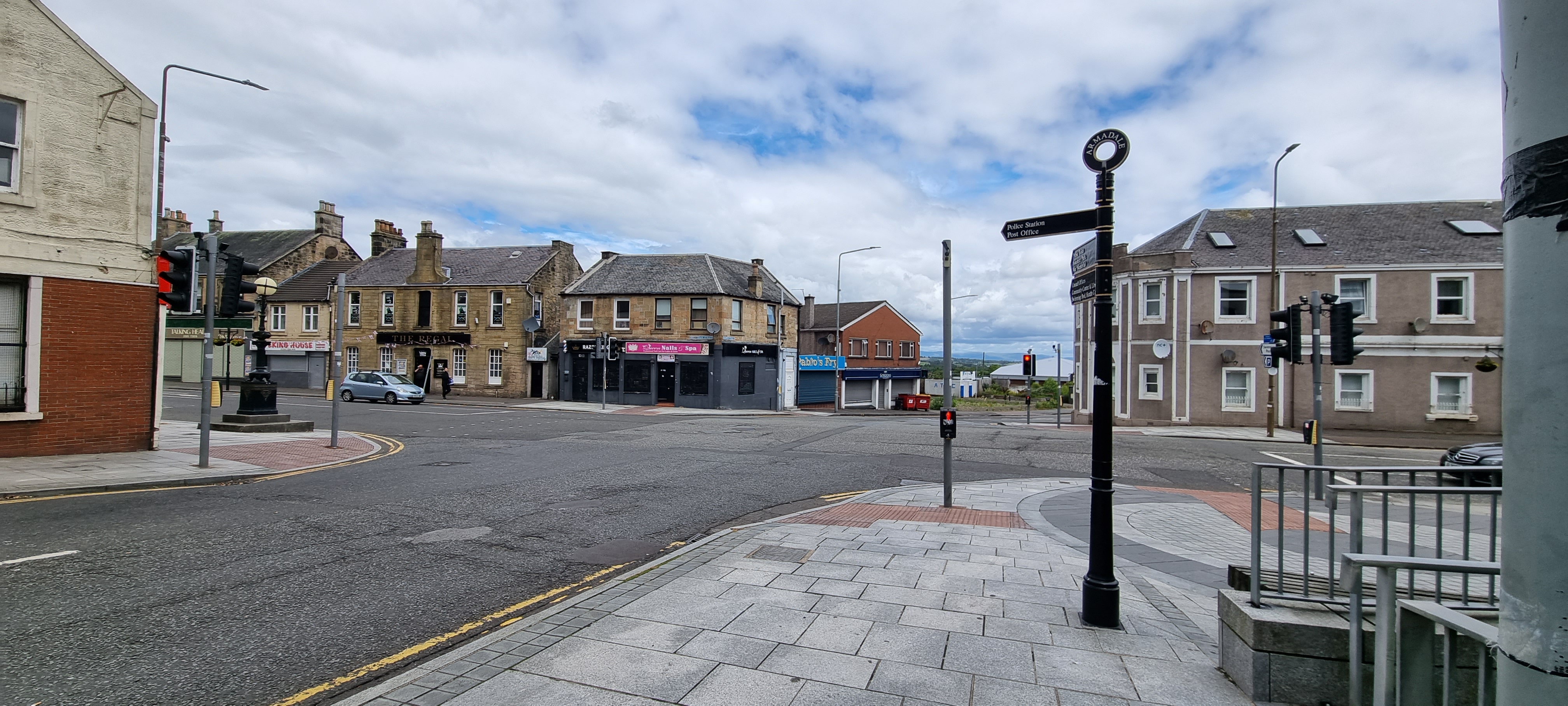
Armadale is a town located in the West Lothian county of Scotland. Situated about 2.5 miles west of Bathgate and 27 miles west of Edinburgh, Armadale offers a convenient location for both commuters and residents alike.

With a population of around 9,000 people, Armadale provides a close-knit community atmosphere. The town boasts a range of amenities, including local shops, supermarkets, cafes, and restaurants, ensuring residents have easy access to daily necessities. There are also several local schools, making it an ideal place for families.

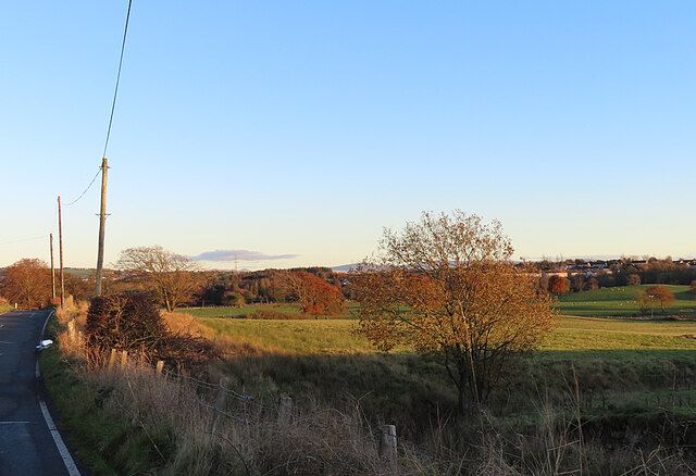
Armadale is known for its rich history and heritage. The town was once a major center for coal mining, and remnants of this industry can still be seen today. The Armadale Castle, a historic site from the 18th century, stands as a reminder of the town's past. Additionally, the nearby Blackridge and Armadale railway stations provide convenient transportation links for both commuters and visitors.

Nature enthusiasts can enjoy the picturesque countryside surrounding Armadale, with opportunities for outdoor activities such as hiking, cycling, and fishing. The nearby Bathgate Hills offer stunning views and scenic walking trails, while the Armadale Community Wildlife Garden provides a peaceful retreat for those seeking tranquility.

Overall, Armadale is a charming town that offers a mix of history, amenities, and natural beauty. Its convenient location, strong community spirit, and range of recreational opportunities make it an appealing place to live or visit in West Lothian.

If you have any feedback on the listing, please let us know in the comments section below.

Armadale Images

Images are sourced within 2km of 55.898755/-3.700085 or Grid Reference NS9368. Thanks to Geograph Open Source API. All images are credited.

Armadale Railway Station View from the footbridge towards Edinburgh.
Opened in 2010 by Network Rail on the line from Airdrie to Bathgate, now one of four lines between Edinburgh and Glasgow.
Armadale Railway Station
View from the footbridge towards Edinburgh. Opened in 2010 by Network Rail on the line from Airdrie to Bathgate, now one of four lines between Edinburgh and Glasgow.
Armadale Railway Station View from the footbridge towards Blackridge and Airdrie.
Opened in 2010 by Network Rail on the line from Airdrie to Bathgate, now one of four lines between Edinburgh and Glasgow.
Armadale Railway Station
View from the footbridge towards Blackridge and Airdrie. Opened in 2010 by Network Rail on the line from Airdrie to Bathgate, now one of four lines between Edinburgh and Glasgow.
Armadale Railway Station Abellio ScotRail Class 334 No. 334039 departing foe Edinburgh.
Armadale Railway Station
Abellio ScotRail Class 334 No. 334039 departing foe Edinburgh.
Armadale Railway Station Towards Blackridge and Airdrie.
Opened in 2010 by Network Rail on the line from Airdrie to Bathgate, now one of four lines between Edinburgh and Glasgow.
Armadale Railway Station
Towards Blackridge and Airdrie. Opened in 2010 by Network Rail on the line from Airdrie to Bathgate, now one of four lines between Edinburgh and Glasgow.
Footbridge, Armadale Railway Station Line towards Edinburgh.
Opened in 2010 by Network Rail on the line from Airdrie to Bathgate, now one of four lines between Edinburgh and Glasgow.
Footbridge, Armadale Railway Station
Line towards Edinburgh. Opened in 2010 by Network Rail on the line from Airdrie to Bathgate, now one of four lines between Edinburgh and Glasgow.
Armadale Railway Station Abellio ScotRail Class 334 No. 334014 arriving on a service from Edinburgh.
Armadale Railway Station
Abellio ScotRail Class 334 No. 334014 arriving on a service from Edinburgh.
Arnold Clark Armadale Citroen
The Rowan Tree,  Armadale On Southdale Way.
The Rowan Tree, Armadale
On Southdale Way.
Sign for the Rowan Tree,  Armadale See <a href="https://www.geograph.org.uk/photo/6969861">NS9467 : The Rowan Tree,  Armadale</a> for context.
Sign for the Rowan Tree, Armadale
Pond at Western Edge of Hardhill Wood It is unclear whether this pond - which sits immediately off a major path through the wood  - is a balancing pond constructed to deal with occasional large outflows of water from the relatively new (15-20 years old I reckon) housing estate just East of here, a pond designed to filter pollutants from the water percolating through what was previously a heavily mined area, or a combination of both. The presence of a number of tall reeds, which are mostly behind camera, usually indicates some kind of clean-up operation is at work.
The pond is situated right next to an old shaft for Hopetoun Colliery No 8 Pit. The mine first appears on an 1890s OS map, but sifting through patchy online information it appears it may well have been operational as far back as the 1860s. As usual, rather soberingly, a lot of the information that can be gleaned about the pit comes from reports of accidents and fatalities. The Durham Mining Museum website has the most comprehensive overview of its workings that I have found. Unfortunately though it gets lumped together with the No 9 Pit (which was sited a few hundred yards SouthWest of here), so there are no exact figures, but an average of 300 men were employed underground across the two pits for the bulk of the first half of the 20th Century. The fatality reports only mention coal, so it seems likely that they were both exclusively coal mines, as opposed to a number round here, which mined combinations of coal, shale and ironstone.
Pond at Western Edge of Hardhill Wood
It is unclear whether this pond - which sits immediately off a major path through the wood - is a balancing pond constructed to deal with occasional large outflows of water from the relatively new (15-20 years old I reckon) housing estate just East of here, a pond designed to filter pollutants from the water percolating through what was previously a heavily mined area, or a combination of both. The presence of a number of tall reeds, which are mostly behind camera, usually indicates some kind of clean-up operation is at work. The pond is situated right next to an old shaft for Hopetoun Colliery No 8 Pit. The mine first appears on an 1890s OS map, but sifting through patchy online information it appears it may well have been operational as far back as the 1860s. As usual, rather soberingly, a lot of the information that can be gleaned about the pit comes from reports of accidents and fatalities. The Durham Mining Museum website has the most comprehensive overview of its workings that I have found. Unfortunately though it gets lumped together with the No 9 Pit (which was sited a few hundred yards SouthWest of here), so there are no exact figures, but an average of 300 men were employed underground across the two pits for the bulk of the first half of the 20th Century. The fatality reports only mention coal, so it seems likely that they were both exclusively coal mines, as opposed to a number round here, which mined combinations of coal, shale and ironstone.
Cairn in Hardhill Wood Hectares are usually described in terms of football pitches these days. Whereas an acre is about the size of half of the playing area of the average sized football pitch, a hectare is often given as the area of a whole football pitch including the grass behind the goals and beyond the touch lines, or sidelines. (Theoretically a football pitch could be square, but due to rules imposed by international, national, and regional football bodies, pitches are generally about 115 x 75 yards in dimension with a bit of leeway given in both directions.) If you submit pictures to Geograph though, things become far simpler - a hectare is exactly the same as a centisquare, which is a hundredth part of a grid-square, measuring 100 x 100 metres. This small broadleaf wood comes in at about 10 hectares.
Cairns like this are extremely common these days, and generally have something to do with one of the Queen's umpteen jubilees, or the millennium. This one, though, was something of a curiosity. It has the Scout logo - which can just be made out on its right side - engraved on one stone, with 'N East' imprinted below the logo, and a handful of other engraved stones and bricks throughout, which all denote Scout troops in and around Aberdeenshire - '1st Banff Scouts' and '1st Laurencekirk' are visible here. According to the Woodland Trust website, which handily also contains information on a lot of other publicly designed woodlands, it is one of six decorative cairns representing the Scout regions of Scotland. This is because in 1999 local Scouts planted all the trees here, which must have taken some doing. Presumably all the Scout troops marked on the stones were involved in the project, and get an honourary name-check in all the other woods.
The reason I never put links in my write-ups, and therefore end up writing so much, is because of the wholly unnecessary (so it seems to me, anyway) practise of constant renaming and rebranding, undertaken by almost every organisation out there. This is a case in point. At the time, the wood was planted on behalf of the Central Scotland Forest Trust. This then renamed itself the Central Scotland Green Network Trust and is now called Green Action Trust. It seems to be quite a force for good though, despite its identity crisis.
Cairn in Hardhill Wood
Hectares are usually described in terms of football pitches these days. Whereas an acre is about the size of half of the playing area of the average sized football pitch, a hectare is often given as the area of a whole football pitch including the grass behind the goals and beyond the touch lines, or sidelines. (Theoretically a football pitch could be square, but due to rules imposed by international, national, and regional football bodies, pitches are generally about 115 x 75 yards in dimension with a bit of leeway given in both directions.) If you submit pictures to Geograph though, things become far simpler - a hectare is exactly the same as a centisquare, which is a hundredth part of a grid-square, measuring 100 x 100 metres. This small broadleaf wood comes in at about 10 hectares. Cairns like this are extremely common these days, and generally have something to do with one of the Queen's umpteen jubilees, or the millennium. This one, though, was something of a curiosity. It has the Scout logo - which can just be made out on its right side - engraved on one stone, with 'N East' imprinted below the logo, and a handful of other engraved stones and bricks throughout, which all denote Scout troops in and around Aberdeenshire - '1st Banff Scouts' and '1st Laurencekirk' are visible here. According to the Woodland Trust website, which handily also contains information on a lot of other publicly designed woodlands, it is one of six decorative cairns representing the Scout regions of Scotland. This is because in 1999 local Scouts planted all the trees here, which must have taken some doing. Presumably all the Scout troops marked on the stones were involved in the project, and get an honourary name-check in all the other woods. The reason I never put links in my write-ups, and therefore end up writing so much, is because of the wholly unnecessary (so it seems to me, anyway) practise of constant renaming and rebranding, undertaken by almost every organisation out there. This is a case in point. At the time, the wood was planted on behalf of the Central Scotland Forest Trust. This then renamed itself the Central Scotland Green Network Trust and is now called Green Action Trust. It seems to be quite a force for good though, despite its identity crisis.
Scrubby woodland Small areas of woodland amongst agricultural land like this one, in this part of West Lothian, generally hint to there having been some mining activity at the location in the past. Old maps provide faint clues, but nothing conclusive - a small triangle at the North of the wood, long occupied by Campbell's vehicle scrapyard, roughly occupies a former spoilheap. The heap is shown on an 1890s OS map, but no nearby workings are ever shown - it is quite possible though, that something sprung up and got wound up within the 40-plus year period between the Ordnance Survey's first and second editions. Then again, the scrubby woodland is marked as boggy - unlike the surrounding fields - in their first 1850s map, and therefore was probably not farmable anyway, so it's hard to say.
To add to the mystery,  an interlinking road once ran from the main Armadale to Bathgate road and the 'scrapyard road' (as it's now commonly called) to the North. And off this shortcut once ran a spur to nowhere, for a short distance at the SouthWest of today's wood. It now resembles a short unfilled moat and it is hard to figure out if the old track was the high bit or the low bit, and whichever it was, why there is about a four foot drop between the two.
The field to the South must always have been arable as there is no fence between it and the wood. And a couple of big bulky metal things are covered in moss in the wood - they looked like very old engines, probably dumped there due to some criminal activity in long-gone days before cybercrime took over.
Scrubby woodland
Small areas of woodland amongst agricultural land like this one, in this part of West Lothian, generally hint to there having been some mining activity at the location in the past. Old maps provide faint clues, but nothing conclusive - a small triangle at the North of the wood, long occupied by Campbell's vehicle scrapyard, roughly occupies a former spoilheap. The heap is shown on an 1890s OS map, but no nearby workings are ever shown - it is quite possible though, that something sprung up and got wound up within the 40-plus year period between the Ordnance Survey's first and second editions. Then again, the scrubby woodland is marked as boggy - unlike the surrounding fields - in their first 1850s map, and therefore was probably not farmable anyway, so it's hard to say. To add to the mystery, an interlinking road once ran from the main Armadale to Bathgate road and the 'scrapyard road' (as it's now commonly called) to the North. And off this shortcut once ran a spur to nowhere, for a short distance at the SouthWest of today's wood. It now resembles a short unfilled moat and it is hard to figure out if the old track was the high bit or the low bit, and whichever it was, why there is about a four foot drop between the two. The field to the South must always have been arable as there is no fence between it and the wood. And a couple of big bulky metal things are covered in moss in the wood - they looked like very old engines, probably dumped there due to some criminal activity in long-gone days before cybercrime took over.
Grazing Land Grassy fields beside the minor road north of Armadale.
Grazing Land
Grassy fields beside the minor road north of Armadale.
Armadale Stadium Located on Bathgate Road, this is the home of the Edinburgh Monarchs speedway team. Viewed on a bright but icy December day.
Armadale Stadium
Located on Bathgate Road, this is the home of the Edinburgh Monarchs speedway team. Viewed on a bright but icy December day.
Armadale Methodist Church Viewed in late-December sunshine.
Armadale Methodist Church
Viewed in late-December sunshine.
Westermains view Residential area in the west end of Armadale.
Westermains view
Residential area in the west end of Armadale.
Pool at Mallace Avenue View from the footpath towards the new housing estate at Mallace Avenue, Lower Bathville.  Before the estate was built this area was a cornfield so the pool is as new as the houses, but very natural-looking and well-established.
Pool at Mallace Avenue
View from the footpath towards the new housing estate at Mallace Avenue, Lower Bathville. Before the estate was built this area was a cornfield so the pool is as new as the houses, but very natural-looking and well-established.
Earthwork at Lower Bathville The small standing stone was erected by the Boy Scouts during some kind of Millennium celebration, but I haven't been able to find out anything about the horseshoe-shaped earthwork.

It definitely pre-dates the local housing estate, because it can be seen in aerial photographs taken before the houses were built.  Somebody who has lived nearby for sixteen years told me it was there when he moved in.  It doesn't seem to be a marker on top of a septic tank and it's too low and too small to be a sheep-fold, yet it's not marked on the OS map as an ancient monument either.  Some kind of Victorian folly, possibly?
Earthwork at Lower Bathville
The small standing stone was erected by the Boy Scouts during some kind of Millennium celebration, but I haven't been able to find out anything about the horseshoe-shaped earthwork. It definitely pre-dates the local housing estate, because it can be seen in aerial photographs taken before the houses were built. Somebody who has lived nearby for sixteen years told me it was there when he moved in. It doesn't seem to be a marker on top of a septic tank and it's too low and too small to be a sheep-fold, yet it's not marked on the OS map as an ancient monument either. Some kind of Victorian folly, possibly?
Show me another place!

Armadale is located at Grid Ref: NS9368 (Lat: 55.898755, Lng: -3.700085)

Unitary Authority: West Lothian

Police Authority: The Lothians and Scottish Borders

What 3 Words

///gown.scrum.enough. Near Armadale, West Lothian

Nearby Locations

Armadale

Related Wikis

Volunteer Park, Armadale

Volunteer Park is a football ground in Armadale, West Lothian, Scotland. It is the home ground of Armadale Thistle, and was used by several of the town...

Armadale, West Lothian

Armadale (Scots: Airmadale, Scottish Gaelic: Armadal) is a town within the county of West Lothian in the Central Belt of Scotland. It lies to the west...

Armadale Academy

Armadale Academy is a secondary school in Armadale, West Lothian. Opened in 1969, the academy moved to its current location in 2009. It is split into three...

Armadale Stadium

Armadale Stadium is a motorcycle speedway and former greyhound racing stadium situated in the town of Armadale, West Lothian in Scotland. Stock car racing...

Nearby Amenities

Located within 500m of 55.898755,-3.700085
Traffic Signals
Armadale Cross
Lat/Long: 55.898709/-3.700039
Crossing
Button Operated: yes
Crossing: traffic_signals
Crossing Ref: pelican
Tactile Paving: yes
Lat/Long: 55.8985917/-3.7014484
Bus Stop
The Cavalier
Naptan AtcoCode: 6290A03
Naptan Bearing: E
Naptan CommonName: The Cavalier
Naptan Indicator: at
Naptan NaptanCode: 95623294
Naptan Street: East Main Street
Public Transport: platform
Lat/Long: 55.8990478/-3.6937848
Bus Stop
Barbauchlaw Avenue
Bus: yes
Naptan AtcoCode: 6290A05
Naptan Bearing: E
Naptan CommonName: Barbauchlaw Avenue
Naptan Indicator: opp
Naptan NaptanCode: 95623472
Naptan Street: East Main Street
Public Transport: platform
Lat/Long: 55.8988161/-3.6984992
Turning Circle
Lat/Long: 55.8957532/-3.6982642
Post Office
Source: OS OpenData StreetView
Lat/Long: 55.8976841/-3.6994514
Post Box
Collection Times: Mo-Fr 09:00; Sa 07:00
Post Box Type: pillar
Ref: EH48 33D
Royal Cypher: GR
Royal Cypher Wikidata: Q33102273
Source: survey
Lat/Long: 55.8988399/-3.6957827
Pub
Krossbar
Addr City: Armadale
Addr Postcode: EH48 3EW
Contact Facebook: https://www.facebook.com/profile.php?id=100090045968950
Lat/Long: 55.8983073/-3.7003156
Fast Food
Oriental Star
Addr City: Armadale
Addr Housenumber: 10
Addr Postcode: EH48 2NS
Addr Street: East Main Street
Cuisine: chinese
Fhrs Id: 588379
Source Addr: FHRS Open Data
Lat/Long: 55.8988415/-3.6991371
Fast Food
Taste of China
Addr City: Armadale
Addr Housenumber: 11
Addr Postcode: EH48 3EW
Addr Street: South Street
Cuisine: chinese
Fhrs Id: 588343
Source Addr: FHRS Open Data
Lat/Long: 55.89818/-3.6998879
Post Box
Note: no ref or collection times displayed
Operator: Royal Mail
Lat/Long: 55.8975846/-3.6995052
Post Box
Note: collection times changed but paper label illegible
Operator: Royal Mail
Post Box Type: pillar
Ref: EH48 38
Royal Cypher: scottish_crown
Lat/Long: 55.8976353/-3.6999563
Atm
Brand: Clydesdale Bank
Lat/Long: 55.8979244/-3.7074072
Entrance: main
Lat/Long: 55.8979695/-3.7072639
Recycling
Recycling Clothes: yes
Recycling Type: container
Lat/Long: 55.8984224/-3.69881
Post Box
Collection Times: Mo-Fr 09:00; Sa 07:00
Operator: Royal Mail
Post Box Type: pillar
Ref: EH48 31D
Royal Cypher: scottish_crown
Lat/Long: 55.9031672/-3.7008813
Booth: K6
Removed Amenity: telephone
Lat/Long: 55.9032046/-3.7008562
Turning Circle
Lat/Long: 55.8973081/-3.698697
Atm
Brand: Royal Bank of Scotland
Opening Hours: 24/7
Lat/Long: 55.8973753/-3.6999305
Ice Cream
J & G Coia Sweet Shop
Addr City: Armadale
Addr Housenumber: 68-70
Addr Postcode: EH48 3QA
Addr Street: West Main Street
Fhrs Id: 587939
Source Addr: FHRS Open Data
Lat/Long: 55.8984596/-3.7032616
Fast Food
Tastebuds
Addr City: Armadale
Addr Housenumber: 65
Addr Postcode: EH48 3PZ
Addr Street: West Main Street
Fhrs Id: 588066
Source Addr: FHRS Open Data
Takeaway: yes
Lat/Long: 55.8982821/-3.7026378
Bus Stop
Bench: no
Shelter: no
Lat/Long: 55.8982577/-3.7035365
Shop: hairdresser
Lat/Long: 55.8982912/-3.7025698
Post Box
Brand: Royal Mail
Brand Wikidata: Q638098
Brand Wikipedia: en:Royal Mail
Collection Times: Mo-Fr 16:00; Sa 08:30
Operator: Royal Mail
Operator Wikidata: Q638098
Post Box Type: pillar
Ref: EH47 34
Royal Cypher: scottish_crown
Lat/Long: 55.8983187/-3.7028812
Armadale MOT Test Centre
Shop: car_repair
Lat/Long: 55.8947332/-3.7011514
Bus Stop
Wotherspoon Crescent
Bench: yes
Naptan AtcoCode: 6290A19
Naptan Bearing: S
Naptan CommonName: Wotherspoon Crescent
Naptan Indicator: after
Naptan NaptanCode: 95623454
Naptan Street: South Street
Public Transport: platform
Shelter: yes
Lat/Long: 55.8950194/-3.7007746
Bus Stop
Wotherspoon Crescent
Bench: yes
Bus: yes
Naptan AtcoCode: 6290A20
Naptan Bearing: NE
Naptan CommonName: Wotherspoon Crescent
Naptan Indicator: opp
Naptan NaptanCode: 95623456
Naptan Street: South Street
Public Transport: platform
Shelter: yes
Lat/Long: 55.8954628/-3.7007561
Traffic Calming: choker
Lat/Long: 55.8963903/-3.704596
Crossing
Button Operated: yes
Crossing: traffic_signals
Crossing Ref: pelican
Lat/Long: 55.896876/-3.7002164
Historic: memorial
Inscription: In memory of Mrs Elizabeth Kerr
Memorial: plaque
Start Date: 26/11/1919
Lat/Long: 55.8986355/-3.7002575
Fast Food
Foo Wing
Addr City: Armadale
Addr Housenumber: 133
Addr Postcode: EH48 3JA
Addr Street: West Main Street
Cuisine: chinese
Fhrs Id: 799314
Source Addr: FHRS Open Data
Takeaway: only
Lat/Long: 55.8979686/-3.7050014
Bus Stop
Bench: yes
Shelter: yes
Lat/Long: 55.8982355/-3.7043625
Telephone
Booth: KX100
Covered: booth
Lat/Long: 55.8986053/-3.7007748
Armadale
Is In: West Lothian
Name En: Armadale
Name Gd: Armadal
Name Sco: Airmadal
Place: town
Population: 12720
Population Date: mid-2020 estimate
Source Population: wikipedia
Wikidata: Q2706897
Wikipedia: en:Armadale, West Lothian
Lat/Long: 55.898767/-3.7001955
Turning Circle
Lat/Long: 55.8961379/-3.6971884
Library
Lat/Long: 55.900844/-3.6995762
Bus Stop
Bus: yes
Public Transport: platform
Lat/Long: 55.9006873/-3.6986195
Community Centre
The Armadale Shed
Addr City: Armadale
Addr Housenumber: 7
Addr Street: South Street
Website: https://www.armadaleshed.org.uk/
Lat/Long: 55.8981177/-3.6996134
Crossing
Crossing: traffic_signals
Lat/Long: 55.8978073/-3.7000679
Bus Stop
Hunting Lodge
Bus: yes
Naptan AtcoCode: 6290A22
Naptan Bearing: S
Naptan CommonName: Hunting Lodge
Naptan Indicator: opp
Naptan NaptanCode: 95623453
Naptan Street: South Street
Public Transport: platform
Lat/Long: 55.8982655/-3.6999856
Bus Stop
Hunting Lodge
Bus: yes
Naptan AtcoCode: 6290A21
Naptan Bearing: N
Naptan CommonName: Hunting Lodge
Naptan Indicator: after
Naptan NaptanCode: 95623452
Naptan Street: South Street
Public Transport: platform
Lat/Long: 55.8981379/-3.7001604
Clock
Display: analog
Faces: 3
Man Made: tower
Tower Type: clock
Visibility: area
Lat/Long: 55.8985676/-3.7021519
Pharmacy
Lloyds Pharmacy
Brand: Lloyds Pharmacy
Brand Wikidata: Q6662870
Brand Wikipedia: en:LloydsPharmacy
Dispensing: yes
Healthcare: pharmacy
Lat/Long: 55.8984931/-3.7011522
Pharmacy
Gordons Chemists
Addr City: Armadale
Addr Housenumber: 7
Addr Postcode: EH48 3QB
Addr Street: North Street
Brand: Gordons Chemists
Brand Wikidata: Q17984545
Dispensing: yes
Healthcare: pharmacy
Lat/Long: 55.898997/-3.7001058
Man Made: mast
Tower Type: communication
Lat/Long: 55.9007362/-3.6967117
Man Made: mast
Tower Type: communication
Lat/Long: 55.9006918/-3.6963241
The data included in this document is from www.openstreetmap.org. The data is made available under ODbL.

Have you been to Armadale?

Leave your review of Armadale below (or comments, questions and feedback).