Humble Bee Coppice

Wood, Forest in Gloucestershire Cotswold

England

Humble Bee Coppice

A429 heading north The Roman Foss Way.
A429 heading north Credit: Robin Webster

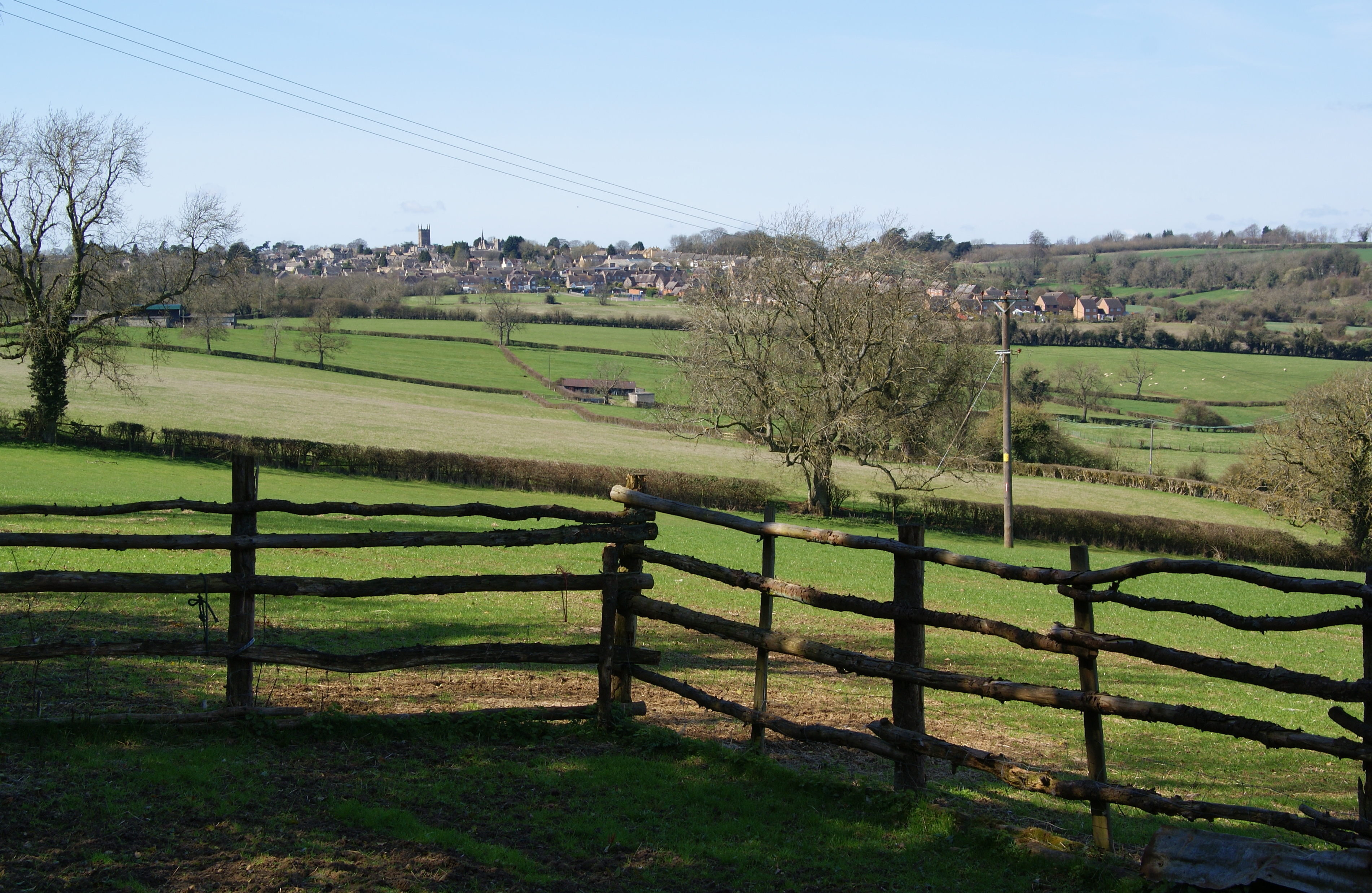
Humble Bee Coppice is a picturesque woodland area located in Gloucestershire, England. Spanning over 100 acres, this charming forest is known for its lush greenery, diverse wildlife, and tranquil atmosphere. The coppice is situated on the outskirts of a small village, offering visitors a peaceful retreat away from the hustle and bustle of urban life.

The woodland is predominantly composed of native tree species such as oak, beech, and ash, which provide a dense canopy cover and create a haven for various flora and fauna. The forest floor is adorned with an array of wildflowers, including bluebells and primroses, adding pops of color to the otherwise verdant landscape.

Humble Bee Coppice is home to a wide range of wildlife, making it a popular spot for nature enthusiasts and birdwatchers. Visitors may spot various bird species, such as woodpeckers, owls, and finches, as well as small mammals like foxes, badgers, and squirrels. The forest is also known for its butterfly population, with species like the common blue and orange tip fluttering among the trees.

For those seeking outdoor activities, the woodland offers numerous walking trails and paths, allowing visitors to explore its beauty at their own pace. There are also designated picnic areas where visitors can relax and enjoy a peaceful meal amidst nature.

Overall, Humble Bee Coppice in Gloucestershire is a delightful destination for nature lovers, offering a serene environment, diverse flora and fauna, and ample opportunities for exploration and relaxation.

If you have any feedback on the listing, please let us know in the comments section below.

Humble Bee Coppice Images

Images are sourced within 2km of 51.95842/-1.7342662 or Grid Reference SP1828. Thanks to Geograph Open Source API. All images are credited.

A429 heading north The Roman Foss Way.
A429 heading north
The Roman Foss Way.
Fosse Way (A429) heading north Towards Warwick.
Fosse Way (A429) heading north
Towards Warwick.
Tree at the side of Fosse Way
Cudds Farm and farm shop
The former Coach & Horses, Ganborough, Glos This used to be a public house run by Donnington Brewery, a small Cotswold brewery. It is on the A424 Stow-on-the-Wold to Broadway road. A few months ago the pub was closed, and all signage has been removed. It was sometimes confused with the Coach & Horses pub at Longborough, which is very near to here, and is also owned by Donnington Brewery. At present there is a noticeboard outside suggesting that potential patrons go to the pub at Longborough.

The pub, when open, is shown in this January 2011 photograph by Bill Nicholls:- <a href="https://www.geograph.org.uk/photo/2268730">SP1729 : The Coach and Horses</a>.

<a href="https://www.geograph.org.uk/photo/5091966">SP1729 : Entrance & noticeboard at the former Coach & Horses, Ganborough, Glos</a>.
The former Coach & Horses, Ganborough, Glos
This used to be a public house run by Donnington Brewery, a small Cotswold brewery. It is on the A424 Stow-on-the-Wold to Broadway road. A few months ago the pub was closed, and all signage has been removed. It was sometimes confused with the Coach & Horses pub at Longborough, which is very near to here, and is also owned by Donnington Brewery. At present there is a noticeboard outside suggesting that potential patrons go to the pub at Longborough. The pub, when open, is shown in this January 2011 photograph by Bill Nicholls:- SP1729 : The Coach and Horses. SP1729 : Entrance & noticeboard at the former Coach & Horses, Ganborough, Glos.
Entrance & noticeboard at the former Coach & Horses, Ganborough, Glos This pub closed earlier in 2016 and this noticeboard gives details of the nearby Coach & Horses pub at Longborough. It is also a Donnington Brewery pub.

<a href="https://www.geograph.org.uk/photo/5091956">SP1729 : The former Coach & Horses, Ganborough, Glos</a>.
Entrance & noticeboard at the former Coach & Horses, Ganborough, Glos
This pub closed earlier in 2016 and this noticeboard gives details of the nearby Coach & Horses pub at Longborough. It is also a Donnington Brewery pub. SP1729 : The former Coach & Horses, Ganborough, Glos.
A424 Looking North Near Ganborough
A424 Looking North Passing The Cotswolds Food Store and Cafe
Road from Broadwell to Donnington crossing the A429 Looking north-westward.
Road from Broadwell to Donnington crossing the A429
Looking north-westward.
Donnington Brewery The rooftops of Donnington Brewery <a href="https://www.geograph.org.uk/photo/2533767">SP1727 : Donnington Brewery</a> viewed from the west.
Donnington Brewery
The rooftops of Donnington Brewery SP1727 : Donnington Brewery viewed from the west.
View of Donnington Brewery Donnington Brewery viewed from the road which passes above the valley it is sited in.
View of Donnington Brewery
Donnington Brewery viewed from the road which passes above the valley it is sited in.
Wheat field near Donnington Wheat field above the Donnington Brewery.
Wheat field near Donnington
Wheat field above the Donnington Brewery.
Wheat field near Donnington Wheat field above Donnington between Upper Swell and Longborough.
Wheat field near Donnington
Wheat field above Donnington between Upper Swell and Longborough.
Track and farmland near Longborough After the driest summer in a number of years it is evident here in this view over farmland near Longborough in the Cotswolds.  A footpath follows this headland farmland track.
Track and farmland near Longborough
After the driest summer in a number of years it is evident here in this view over farmland near Longborough in the Cotswolds. A footpath follows this headland farmland track.
Country road above Longborough
Fields West of Longborough
Longborough - High St
Old Milestone by the A424, Longborough Stone post (plate lost) by the A424, in parish of Longborough (Cotswold District), 375m North of Cudds Farm, on the verge, on East side of road. Burford iron plate Erected by the Burford, Ch Norton, Banbury & Aynho turnpike trust in the 19th century. 

Inscription once read:-
(Evesham 13)
(Stow on the Wold 3)
Carved benchmark recorded.   

Milestone Society National ID: GL_SWEV03
Old Milestone by the A424, Longborough
Stone post (plate lost) by the A424, in parish of Longborough (Cotswold District), 375m North of Cudds Farm, on the verge, on East side of road. Burford iron plate Erected by the Burford, Ch Norton, Banbury & Aynho turnpike trust in the 19th century. Inscription once read:- (Evesham 13) (Stow on the Wold 3) Carved benchmark recorded. Milestone Society National ID: GL_SWEV03
Show me another place!

Humble Bee Coppice is located at Grid Ref: SP1828 (Lat: 51.95842, Lng: -1.7342662)

Administrative County: Gloucestershire

District: Cotswold

Police Authority: Gloucestershire

What 3 Words

///skidding.custom.reapply. Near Donnington, Gloucestershire

Related Wikis

Battle of Stow-on-the-Wold

The Battle of Stow-on-the-Wold (21 March 1646) took place during the First English Civil War. It was a Parliamentarian victory by detachments of the New...

Longborough

Longborough is a village and civil parish 2.5 miles (4.0 km) north of the market town of Stow on the Wold, Gloucestershire. The parish population taken...

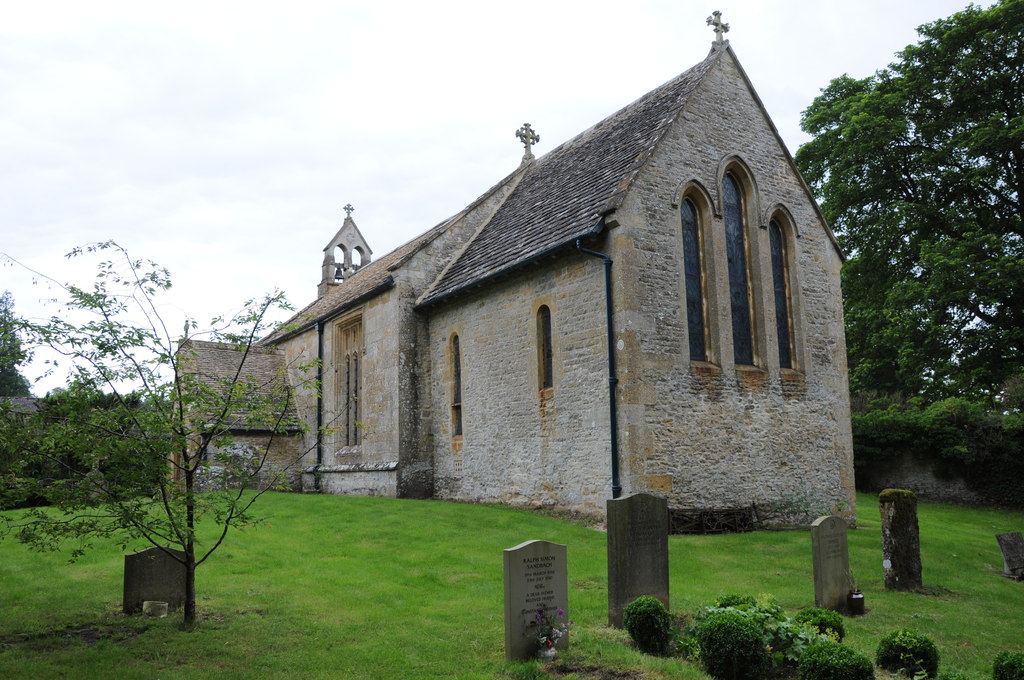
St James' Church, Longborough

St James' Church is the Church of England parish church of Longborough, Gloucestershire, England. It is in the deanery of Stow, the archdeaconry of Cheltenham...

New Park Quarry

New Park Quarry (grid reference SP175282) is a 1.3-hectare (3.2-acre) geological Site of Special Scientific Interest in Gloucestershire, notified in 1987...

Ganborough

Ganborough is a hamlet located along the A424 road, approximately 2 miles NNW of Stow on the Wold. Ganborough is located in Gloucestershire, a county in...

Donnington, Gloucestershire

Donnington is a small village and civil parish in Gloucestershire, near the Roman Fosse Way in the Cotswold District Council area of south west England...

Church of St Mary, Upper Swell

The Anglican Church of St Mary at Upper Swell in the Cotswold District of Gloucestershire, England was built in the 12th century. It is a Grade I listed...

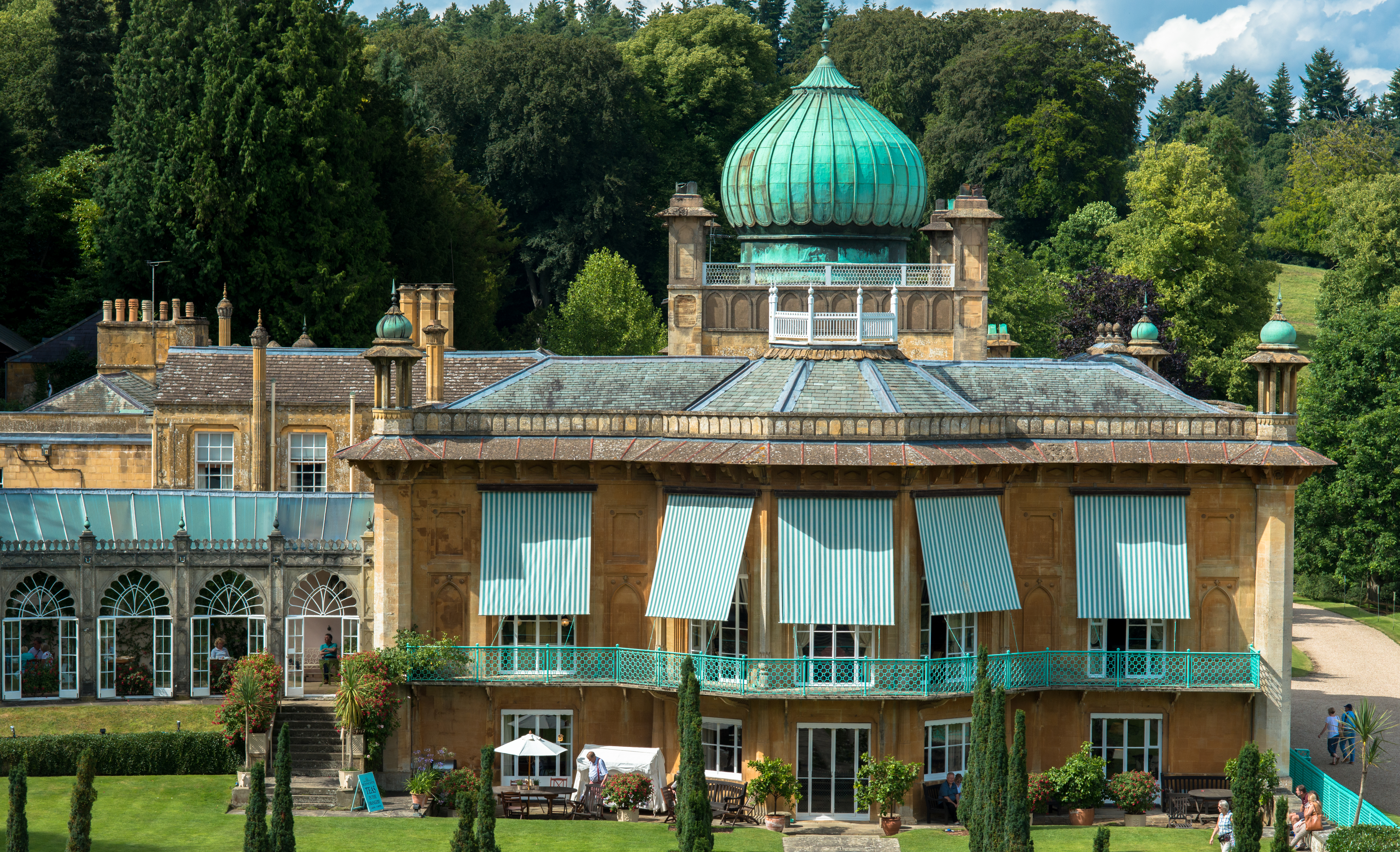
Sezincote (settlement)

Sezincote or Seasoncote is a settlement and civil parish comprising Sezincote House and its estate, situated about 3 miles from Stow-on-the-Wold in the...

Nearby Amenities

Located within 500m of 51.95842,-1.7342662
Stow 1646
Historic: battlefield
Lat/Long: 51.954669/-1.7334467
Barrier: stile
Lat/Long: 51.9556508/-1.7376745
Power: pole
Lat/Long: 51.9614461/-1.7293596
Power: pole
Lat/Long: 51.9620551/-1.7301066
The data included in this document is from www.openstreetmap.org. The data is made available under ODbL.

Have you been to Humble Bee Coppice?

Leave your review of Humble Bee Coppice below (or comments, questions and feedback).