Hollins Wood

Wood, Forest in Yorkshire

England

Hollins Wood

A very tall tree on Cunliffe Lane, Esholt I think that this is a Black Locust (False Acacia), Robinia pseudoacacia.
A very tall tree on Cunliffe Lane, Esholt Credit: Humphrey Bolton

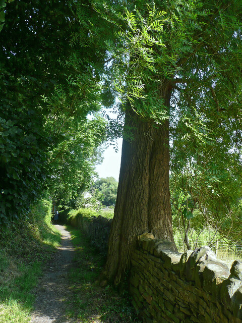
Hollins Wood, located in the picturesque region of Yorkshire, is a stunning forest area that captivates visitors with its natural beauty. Stretching across acres of land, this woodland paradise is a haven for nature enthusiasts and those seeking tranquility away from the bustling city life.

The wood is characterized by its diverse range of trees, including oak, ash, beech, and birch, which create a dense and lush canopy overhead. The forest floor is adorned with a carpet of vibrant wildflowers, such as bluebells and primroses, adding a splash of color to the surroundings.

Numerous walking trails wind their way through Hollins Wood, offering visitors the opportunity to immerse themselves in the serene ambiance and explore its hidden treasures. As one ventures deeper into the woods, they may stumble upon babbling brooks and small ponds, providing a peaceful backdrop to the already captivating scenery.

The wood is home to a variety of wildlife, including deer, foxes, rabbits, and a myriad of bird species. Birdwatchers can delight in the sight of woodpeckers, owls, and other feathered creatures that call this forest their home.

Hollins Wood is a popular destination for outdoor activities such as hiking, picnicking, and photography. Its picturesque landscapes provide an ideal backdrop for capturing breathtaking images of nature's wonders.

Whether it is seeking solace in nature, exploring the biodiversity, or simply enjoying a leisurely stroll, Hollins Wood is a must-visit destination for anyone looking to connect with the natural world and experience the beauty of Yorkshire's woodlands.

If you have any feedback on the listing, please let us know in the comments section below.
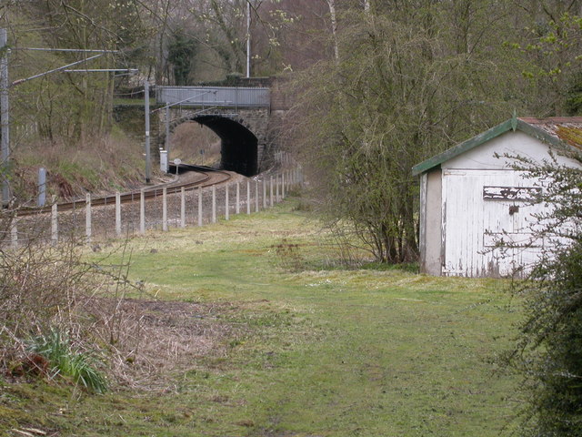
Hollins Wood Images

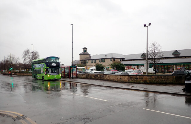
Images are sourced within 2km of 53.861157/-1.722813 or Grid Reference SE1840. Thanks to Geograph Open Source API. All images are credited.

A very tall tree on Cunliffe Lane, Esholt I think that this is a Black Locust (False Acacia), Robinia pseudoacacia.
A very tall tree on Cunliffe Lane, Esholt
I think that this is a Black Locust (False Acacia), Robinia pseudoacacia.
Cunliffe Lane, Esholt This is a wide, surfaced lane up to the site of the former tannery, and then an enclosed footpath up to Hollins Hill.
Cunliffe Lane, Esholt
This is a wide, surfaced lane up to the site of the former tannery, and then an enclosed footpath up to Hollins Hill.
Footpath from Esholt Lane to Cunliffe Lane, Esholt The path looks to have been strimmed, perhaps for hay at the same time that the grass in the field was cut.  See <a href="https://www.geograph.org.uk/photo/6874464">SE1740 : Footpath from Esholt Lane to Cunliffe Lane</a> for previous view of the path.
Footpath from Esholt Lane to Cunliffe Lane, Esholt
The path looks to have been strimmed, perhaps for hay at the same time that the grass in the field was cut. See SE1740 : Footpath from Esholt Lane to Cunliffe Lane for previous view of the path.
Allotments, Esholt Lane, Esholt These are on the site of a sewage filter bed, so are probably very fertile.
Allotments, Esholt Lane, Esholt
These are on the site of a sewage filter bed, so are probably very fertile.
A view of the rear of the Old Hall group of buildings, Esholt Taken using the zoom lens.
A view of the rear of the Old Hall group of buildings, Esholt
Taken using the zoom lens.
The Old School, Esholt Dated 1846. This building is half in Church Lane and half in the churchyard.
The Old School, Esholt
Dated 1846. This building is half in Church Lane and half in the churchyard.
The restored village well, Esholt
The Memorial Institute, Esholt This was built in 1920-1 as a First World War memorial. It is unfortunately rather shaded by trees.
The Memorial Institute, Esholt
This was built in 1920-1 as a First World War memorial. It is unfortunately rather shaded by trees.
Denbirayne Chimney, Tong Park Industrial Estate, Baildon See <a href="https://www.geograph.org.uk/photo/6887736">SE1640 : The Denbirayne chimney</a> for another view and a brief history. Also see <a href="https://www.geograph.org.uk/photo/7096458">SE1640 : Looking Up the Denbirayne Chimney, Tong Park Industrial Estate, Baildon</a> for a much closer view. Tong Park railway viaduct is in the distance.
Denbirayne Chimney, Tong Park Industrial Estate, Baildon
See SE1640 : The Denbirayne chimney for another view and a brief history. Also see SE1640 : Looking Up the Denbirayne Chimney, Tong Park Industrial Estate, Baildon for a much closer view. Tong Park railway viaduct is in the distance.
Otley Road (A65), Guiseley The A65 is a 69 mile long Trans-Pennine road, from Leeds to Kendal.
<span class="nowrap"><a title="http://www.sabre-roads.org.uk/wiki/index.php?title=A65" rel="nofollow ugc noopener" href="http://www.sabre-roads.org.uk/wiki/index.php?title=A65">Link</a><img style="margin-left:2px;" alt="External link" title="External link - shift click to open in new window" src="https://s1.geograph.org.uk/img/external.png" width="10" height="10"/></span>
Otley Road (A65), Guiseley
The A65 is a 69 mile long Trans-Pennine road, from Leeds to Kendal. LinkExternal link
Springfield Court, Guiseley
Junction of Victoria Road, Otley Road (A65) and Oxford Road, Guiseley The A65 is a 69 mile long Trans-Pennine road, from Leeds to Kendal.
<span class="nowrap"><a title="http://www.sabre-roads.org.uk/wiki/index.php?title=A65" rel="nofollow ugc noopener" href="http://www.sabre-roads.org.uk/wiki/index.php?title=A65">Link</a><img style="margin-left:2px;" alt="External link" title="External link - shift click to open in new window" src="https://s1.geograph.org.uk/img/external.png" width="10" height="10"/></span>
Junction of Victoria Road, Otley Road (A65) and Oxford Road, Guiseley
The A65 is a 69 mile long Trans-Pennine road, from Leeds to Kendal. LinkExternal link
Morrisons, Otley Road (A65), Guiseley The A65 is a 69 mile long Trans-Pennine road, from Leeds to Kendal.
<span class="nowrap"><a title="http://www.sabre-roads.org.uk/wiki/index.php?title=A65" rel="nofollow ugc noopener" href="http://www.sabre-roads.org.uk/wiki/index.php?title=A65">Link</a><img style="margin-left:2px;" alt="External link" title="External link - shift click to open in new window" src="https://s1.geograph.org.uk/img/external.png" width="10" height="10"/></span>
Morrisons, Otley Road (A65), Guiseley
The A65 is a 69 mile long Trans-Pennine road, from Leeds to Kendal. LinkExternal link
Looking Up the Denbirayne Chimney, Tong Park Industrial Estate, Baildon I almost fell over backwards taking this image, but it was something I just had to do. See <a href="https://www.geograph.org.uk/photo/7084813">SE1640 : Denbirayne Chimney, Tong Park Industrial Estate, Baildon</a> for a more distant view.
Looking Up the Denbirayne Chimney, Tong Park Industrial Estate, Baildon
I almost fell over backwards taking this image, but it was something I just had to do. See SE1640 : Denbirayne Chimney, Tong Park Industrial Estate, Baildon for a more distant view.
High View, Esholt
High View, Esholt
Station Road, Esholt
Station Road, Esholt The viaduct crossing the road carries the Leeds-Skipton railway line.
Station Road, Esholt
The viaduct crossing the road carries the Leeds-Skipton railway line.
Main Street seen from Station Road, Esholt
Show me another place!

Hollins Wood is located at Grid Ref: SE1840 (Lat: 53.861157, Lng: -1.722813)

Division: West Riding

Unitary Authority: Bradford

Police Authority: West Yorkshire

What 3 Words

///assure.raves.jeeps. Near Guiseley, West Yorkshire

Related Wikis

Esholt

Esholt is a village and former civil parish in the metropolitan district of the City of Bradford, West Yorkshire, England. It is situated 3 miles (4.8...

Esholt railway station

Esholt railway station was a railway station on the Shipley to Guiseley line of the Midland Railway. It opened on 4 December 1876 along with Baildon station...

Esholt Priory

Esholt Priory was a Cistercian priory in West Yorkshire, England which was sold after the Dissolution of the Monasteries, and the present Grade II* listed...

Esholt Junction rail crash

The Esholt Junction rail crash occurred on Thursday 9 June 1892, at the point at which the Otley and Ilkley Joint Railway from Ilkley divides, one branch...

Guiseley School

Guiseley School is a Mixed Secondary School and Sixth Form located in Guiseley in the City of Leeds, West Yorkshire, England.Guiseley School offers GCSEs...

Aireborough Grammar School

Aireborough Grammar School was an English state grammar school situated on the Yeadon / Guiseley border in Aireborough, West Yorkshire. The school was...

Guiseley Theatre

Guiseley Theatre, formerly Guiseley Town Hall, is a municipal building at The Green, Guiseley, West Yorkshire, England. The structure, which was once the...

Thackley A.F.C.

Thackley A.F.C. are a football club based in Thackley, north Bradford, West Yorkshire, England. The club plays in the Northern Counties East League Premier...

Nearby Amenities

Located within 500m of 53.861157,-1.722813
Source: landsat
Lat/Long: 53.8589141/-1.7212495
Source: landsat
Lat/Long: 53.8579603/-1.7219738
Esholt
Historic Railway: station
Railway: site
Wikidata: Q5397885
Wikipedia: en:Esholt railway station
Lat/Long: 53.8607031/-1.729078
Bus Stop
Station Road Main Street
Local Ref: 45018847
Naptan AtcoCode: 450018847
Naptan Bearing: N
Naptan CommonName: Station Road Main Street
Naptan Crossing: Main Street
Naptan Indicator: Stop 45018847
Naptan Landmark: St Leonards Farm
Naptan PlusbusZoneRef: LEEDS
Naptan ShortCommonName: Main Street
Naptan Street: Station Road
Naptan Verified: no
Source: naptan_import
Lat/Long: 53.858622/-1.7247438
Barrier: kissing_gate
Lat/Long: 53.859988/-1.7244149
Pub
Woolpack
Addr City: Shipley
Addr Housenumber: 20
Addr Postcode: BD17 7QZ
Addr Street: Main Street
Addr Village: Esholt
Fhrs Id: 326058
Source Addr: FHRS Open Data
Lat/Long: 53.858609/-1.7240939
Post Office
Esholt Post Office
Addr City: Shipley
Addr Housenumber: 21
Addr Postcode: BD17 7QZ
Addr Street: Main Street
Addr Village: Esholt
Brand: Post Office
Brand Wikidata: Q1783168
Fhrs Id: 326059
Opening Hours: Mo,We-Fr 09:00-12:00,13:00-17:30; Tu 09:00-13:00; Sa 09:00-12:30
Ref Pol Id: 90290
Source: OS OpenData StreetView
Source Addr: FHRS Open Data
Website: https://www.postoffice.co.uk/branch-finder/3593061/esholt
Lat/Long: 53.8584187/-1.7243394
Post Box
Collection Times: Mo-Fr 16:45; Sa 11:30
Post Box Mounting: building
Post Box Type: wall
Ref: BD17 940
Royal Cypher: VR
Royal Cypher Wikidata: Q33102356
Lat/Long: 53.8584628/-1.7243056
Telephone
Booth: K6
Covered: booth
Listed Status: Grade II
Phone: +44 1274 581331
Lat/Long: 53.8584735/-1.7242722
The Welcome Way
Hiking: yes
Information: route_marker
Support: pole
Tourism: information
Lat/Long: 53.8585826/-1.7244606
The Welcome Way
Information: route_marker
Tourism: information
Lat/Long: 53.8594103/-1.723564
Barrier: entrance
Bicycle: yes
Foot: yes
Horse: yes
Maxwidth: 3
Lat/Long: 53.8597048/-1.7159722
Access: no
Barrier: entrance
Foot: yes
Material: stone
Note: None of the recognised types of stile. Just an opening in the wall (wider than a squeezer and not flush to the ground)
Step Count: 1
Lat/Long: 53.8647247/-1.7206012
Access: no
Barrier: kissing_gate
Foot: yes
Lat/Long: 53.8650394/-1.7239764
Access: private
Barrier: stile
Foot: yes
Material: stone_and_wood
Stile: stepover
Lat/Long: 53.8650643/-1.7244748
Waste Basket
Operator: City of Bradford
Lat/Long: 53.8618785/-1.7227939
Access: no
Barrier: kissing_gate
Foot: yes
Lat/Long: 53.865034/-1.7239007
Material: wood
Power: pole
Lat/Long: 53.8615177/-1.7265752
Power: pole
Lat/Long: 53.8608012/-1.7154296
Power: pole
Lat/Long: 53.8609451/-1.7170899
Power: pole
Lat/Long: 53.861093/-1.7188467
Material: wood
Power: pole
Lat/Long: 53.8612362/-1.7204399
Material: wood
Power: pole
Lat/Long: 53.8613865/-1.7222075
Material: wood
Power: pole
Lat/Long: 53.8614276/-1.7234695
Material: wood
Power: pole
Lat/Long: 53.8614727/-1.7251137
Material: wood
Power: pole
Lat/Long: 53.861566/-1.7281929
Material: wood
Power: pole
Lat/Long: 53.8616134/-1.729833
Access: no
Barrier: kissing_gate
Foot: yes
Lat/Long: 53.8599712/-1.7241111
Material: wood
Power: pole
Lat/Long: 53.8611136/-1.7264588
Material: wood
Power: pole
Lat/Long: 53.8615834/-1.7259774
Material: wood
Power: pole
Lat/Long: 53.8621993/-1.7253514
Material: wood
Power: pole
Lat/Long: 53.8629667/-1.7248797
Material: wood
Power: pole
Lat/Long: 53.8637002/-1.7244291
Material: wood
Power: pole
Lat/Long: 53.8644139/-1.7239838
Material: wood
Power: pole
Lat/Long: 53.864977/-1.7236412
Power: pole
Lat/Long: 53.8593633/-1.7297325
Power: pole
Lat/Long: 53.8597461/-1.7286354
Power: pole
Lat/Long: 53.8600704/-1.7276859
Power: pole
Lat/Long: 53.8603875/-1.7267767
Power: pole
Lat/Long: 53.8584738/-1.7264467
Power: pole
Lat/Long: 53.8584323/-1.7271093
Power: pole
Lat/Long: 53.8583505/-1.7283055
Direction: north
Hiking: yes
Information: guidepost
Inscription: Public footpath Pullan Lane
Operator: City of Bradford Metropolitan District Council
Tourism: information
Lat/Long: 53.8585829/-1.7244605
Information: guidepost
Inscription: public footpath
Tourism: information
Lat/Long: 53.8647198/-1.7205993
Historic: milestone
Inscription: Otley 4|Bradford 6
Source: NLS OS 25-inch (CC-BY);survey
Wikidata: Q111790527
Wikimedia Commons: File:Milestone- In Place (geograph 6126398).jpg
Lat/Long: 53.8637433/-1.7274226
Welcome Way
Hiking: yes
Information: route_marker
Inscription: Welcome Way
Operator: Walkers Are Welcome
Tourism: information
Url: http://www.welcomeway.org.uk
Lat/Long: 53.8599713/-1.7241173
Waste Basket
Lat/Long: 53.8594466/-1.7236997
Barrier: bollard
Bollard: fixed
Lat/Long: 53.8594191/-1.7236482
Addr Housename: Holme House
Addr Housenumber: 7
Addr Street: Chapel Lane
Lat/Long: 53.8576046/-1.7272173
The data included in this document is from www.openstreetmap.org. The data is made available under ODbL.

Have you been to Hollins Wood?

Leave your review of Hollins Wood below (or comments, questions and feedback).