Broomsgrove Wood

Wood, Forest in Wiltshire

England

Broomsgrove Wood

Poor drainage and road surface, Sunnyhill Lane The worry with this sort of condition is how deep the potholes are under the water. To be taken very slowly.
Poor drainage and road surface, Sunnyhill Lane Credit: Robin Webster

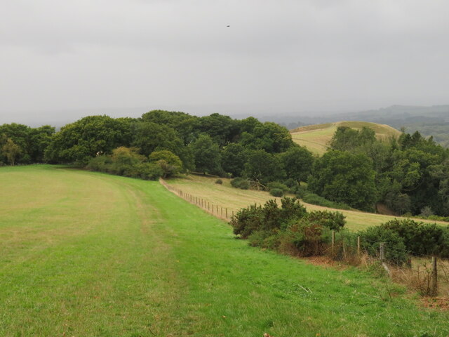
Broomsgrove Wood is a picturesque woodland located in the county of Wiltshire, England. Situated near the village of Broomsgrove, the wood covers an area of approximately 100 acres and is a popular destination for nature lovers and outdoor enthusiasts.

The wood is predominantly made up of native broadleaf trees, including oak, beech, and ash, which provide a rich and diverse habitat for a variety of wildlife. It is a designated Site of Special Scientific Interest (SSSI) due to its significance as a woodland ecosystem.

Visitors to Broomsgrove Wood can enjoy a peaceful and tranquil environment, perfect for walking, hiking, and birdwatching. The well-maintained footpaths and trails offer opportunities to explore the vast woodland and discover its hidden treasures.

The wood is home to a wide range of plant and animal species, including rare and protected species such as the dormouse and lesser spotted woodpecker. The diverse flora and fauna make Broomsgrove Wood an important site for conservation and biodiversity.

In addition to its natural beauty, Broomsgrove Wood also holds historical and archaeological significance. The remains of ancient settlements and burial mounds can be found within the wood, providing a glimpse into the area's past.

Overall, Broomsgrove Wood is a haven of natural beauty and tranquility, offering visitors the chance to immerse themselves in the wonders of the Wiltshire countryside.

If you have any feedback on the listing, please let us know in the comments section below.

Broomsgrove Wood Images

Images are sourced within 2km of 51.366502/-1.7431757 or Grid Reference SU1763. Thanks to Geograph Open Source API. All images are credited.

Poor drainage and road surface, Sunnyhill Lane The worry with this sort of condition is how deep the potholes are under the water. To be taken very slowly.
Poor drainage and road surface, Sunnyhill Lane
The worry with this sort of condition is how deep the potholes are under the water. To be taken very slowly.
Sunnyhill Lane A good stretch of a lane with some badly drained and surfaced parts.
Sunnyhill Lane
A good stretch of a lane with some badly drained and surfaced parts.
Lane crossing of River Avon Not very big here.
Lane crossing of River Avon
Not very big here.
View from the west side of Martinsell Hill View from the White Horse Trail path that runs along the western edge of Martinsell Hill. The view is out towards the Giant's Grave, which has nothing to do with either giants or graves, but is more likely to be a defended settlement site. Some wet weather out in the vale.
View from the west side of Martinsell Hill
View from the White Horse Trail path that runs along the western edge of Martinsell Hill. The view is out towards the Giant's Grave, which has nothing to do with either giants or graves, but is more likely to be a defended settlement site. Some wet weather out in the vale.
Path on the SW side of Martinsell Hill The plateau like top of Martinsell narrows at the SW corner and drops down to a thin spur on which are the earthworks of the Giant's Grave. Two paths join at the edge of the trees in the middle distance, the White Horse Trail merging with the Mid Wilts Way.
Path on the SW side of Martinsell Hill
The plateau like top of Martinsell narrows at the SW corner and drops down to a thin spur on which are the earthworks of the Giant's Grave. Two paths join at the edge of the trees in the middle distance, the White Horse Trail merging with the Mid Wilts Way.
Approaching the Giant's Grave There are several 'Giant's Graves' in Wiltshire and none of them are associated with giants, though one or two might well be ancient burial sites. This one is a scheduled ancient monument and is a promontory fort as opposed to a hill fort. In other words, it makes use of a natural and very steep sided spur of Martinsell Hill, easily defended on all sides except to the east where there is still a considerable bank and ditch which can be seen here.  Excavations have revealed some iron age pottery, but the actual site may be older.
Approaching the Giant's Grave
There are several 'Giant's Graves' in Wiltshire and none of them are associated with giants, though one or two might well be ancient burial sites. This one is a scheduled ancient monument and is a promontory fort as opposed to a hill fort. In other words, it makes use of a natural and very steep sided spur of Martinsell Hill, easily defended on all sides except to the east where there is still a considerable bank and ditch which can be seen here. Excavations have revealed some iron age pottery, but the actual site may be older.
Trig point at the Giant's Grave Trig at the western end of the promontory hill fort of Giant's Grave. Beyond the trig, the path drops down what must be the steepest section of footpath in Wiltshire, the question on this occasion being, would the photographer get to the shelter of trees at the bottom before the heavy shower hit?  [answer - 'yes just']
Trig point at the Giant's Grave
Trig at the western end of the promontory hill fort of Giant's Grave. Beyond the trig, the path drops down what must be the steepest section of footpath in Wiltshire, the question on this occasion being, would the photographer get to the shelter of trees at the bottom before the heavy shower hit? [answer - 'yes just']
Lane entering Littleworth
Field beside the railway, near Fairfield Farm
Kennet and Avon Canal near Milkhouse Water
Kennet and Avon Canal north of Milkhouse Water
New Mill Bridge In late afternoon sunlight
Kennet and Avon Canal west of New Mill Catching the late afternoon sunlight.
Kennet and Avon Canal west of New Mill
Catching the late afternoon sunlight.
Bridleway beside Deane Water Totteridge Farm is just beyond the trees.
Bridleway beside Deane Water
Totteridge Farm is just beyond the trees.
Wootton Rivers Lock
Wootton Rivers Lock
Village street, Wootton Rivers This tin-roofed shed is almost opposite the village hall.
Village street, Wootton Rivers
This tin-roofed shed is almost opposite the village hall.
Class 66 locomotive crossing bridge at New Mill Locomotive catching the morning sunlight, hauling an eastbound train of stone aggregate wagons.
Class 66 locomotive crossing bridge at New Mill
Locomotive catching the morning sunlight, hauling an eastbound train of stone aggregate wagons.
Leaf-strewn bridleway towards Anvill's Farm
Show me another place!

Broomsgrove Wood is located at Grid Ref: SU1763 (Lat: 51.366502, Lng: -1.7431757)

Unitary Authority: Wiltshire

Police Authority: Wiltshire

What 3 Words

///collision.pausing.shipwreck. Near Huish, Wiltshire

Related Wikis

Clench, Wiltshire

Clench is a hamlet in Wiltshire, England, in the Vale of Pewsey to the east of Wootton Rivers. It is in the civil parish of Milton Lilbourne. Its nearest...

Martinsell Hill

Martinsell Hill, near Oare and north of Pewsey, is the third highest point in the county of Wiltshire, southwest England, at some 289 m / 948 ft above...

Wootton Rivers

Wootton Rivers is a small village and civil parish in the Vale of Pewsey, Wiltshire, England. The village lies about 3 miles (5 km) northeast of Pewsey...
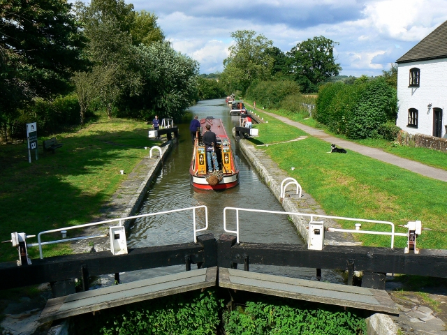
Wootton Rivers Lock

Wootton Rivers Lock, also called Wootton Rivers Bottom Lock, is a lock on the Kennet and Avon Canal at Wootton Rivers, Wiltshire, England. Wootton Rivers...

Wootton Rivers Halt railway station

Wootton Rivers Halt railway station is a former railway station in Wootton Rivers, Wiltshire, England, on the Reading to Taunton line. The station opened...
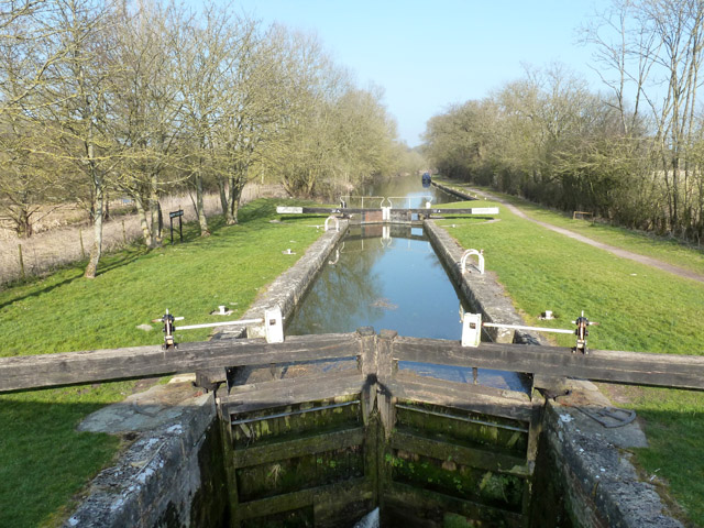
Heathy Close Lock

Heathy Close Lock is a canal lock on the Kennet and Avon Canal, at Wootton Rivers, Wiltshire, England. The lock has a rise/fall of 8 ft 1 in (2.46 m)....

Jones's Mill

Jones's Mill (grid reference SU168613) is an 11.6 hectare biological Site of Special Scientific Interest near Pewsey in Wiltshire, notified in 1975. The...

Oare, Wiltshire

Oare is a small village in the east of the county of Wiltshire, England. The village lies about 2 miles (3.2 km) north of Pewsey, on the A345 road towards...

Have you been to Broomsgrove Wood?

Leave your review of Broomsgrove Wood below (or comments, questions and feedback).