Reservoir Wood
Wood, Forest in Northumberland
England
Reservoir Wood

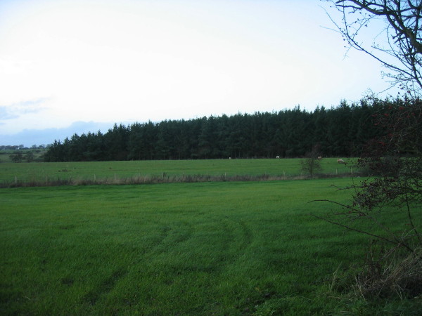
Reservoir Wood is a picturesque woodland located in Northumberland, a county in the northeast of England. Situated near the village of Reservoir, this forested area covers a vast expanse of approximately 200 acres, making it a prominent recreational spot for both locals and tourists.
This woodland is characterized by its diverse range of tree species, including oak, beech, and birch, creating a rich and vibrant ecosystem. The dense canopy formed by these trees provides a cool and shaded environment, making it an ideal destination for nature lovers and hikers, especially during the summer months.
Reservoir Wood is also home to a variety of wildlife, including squirrels, rabbits, and birds. Birdwatchers often flock to the area to observe the numerous species that inhabit the woodland, such as woodpeckers, owls, and songbirds. The tranquil surroundings and peaceful atmosphere make it a perfect place for wildlife enthusiasts and photographers to capture the natural beauty of the forest.
Additionally, Reservoir Wood is famous for its stunning reservoir, which adds to the charm of the area. The reservoir is a man-made water body that not only serves as a scenic backdrop but also provides a habitat for waterfowl and other aquatic creatures.
The woodland is easily accessible, with well-maintained footpaths that crisscross through the forest, allowing visitors to explore the area at their own pace. Whether it's a leisurely stroll or an adventurous hike, Reservoir Wood offers something for everyone, providing a serene and idyllic escape from the hustle and bustle of everyday life.
If you have any feedback on the listing, please let us know in the comments section below.
Reservoir Wood Images
Images are sourced within 2km of 55.26443/-1.7635709 or Grid Reference NZ1596. Thanks to Geograph Open Source API. All images are credited.


Reservoir Wood is located at Grid Ref: NZ1596 (Lat: 55.26443, Lng: -1.7635709)
Unitary Authority: Northumberland
Police Authority: Northumbria
What 3 Words
///fonts.alongside.dodges. Near Longhorsley, Northumberland
Nearby Locations
Related Wikis

Linden Hall, Northumberland
Linden Hall is a former mansion house in the civil parish of Longhorsley, Northumberland, England which is now operated as a hotel and country club. This...

Longhorsley
Longhorsley is a village in Northumberland, England about 7 miles (11 km) northwest of Morpeth, and about 14 miles (23 km) south of Alnwick. The A697 road...
Causey Park House
Causey Park House is a 16th-century former manor house with Grade II listed building status situated at Causey Park, Northumberland, England. The Manors...
Eshott Airfield
Eshott Airfield is a former Royal Air Force (RAF) World War II airfield in the civil parish of Thirston, in the county of Northumberland, England, 20 miles...
Nearby Amenities
Located within 500m of 55.26443,-1.7635709Have you been to Reservoir Wood?
Leave your review of Reservoir Wood below (or comments, questions and feedback).