Rockshill Plantation

Wood, Forest in Wiltshire

England

Rockshill Plantation

Minor road towards Avon Farm
Minor road towards Avon Farm Credit: Helen Steed

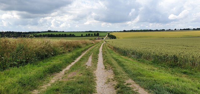
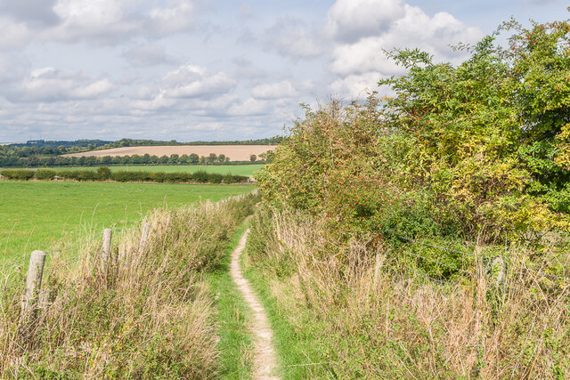
Rockshill Plantation is a picturesque woodland located in Wiltshire, England. Covering an area of approximately 500 acres, it is renowned for its scenic beauty and diverse flora and fauna. The plantation is situated in the southern part of Wiltshire, near the village of Rockshill, and is easily accessible by road.

The woodland is predominantly composed of mature trees, including oak, beech, and ash, which create a dense canopy that provides shelter for various wildlife species. Additionally, the undergrowth is rich in wildflowers, ferns, and mosses, adding to the enchanting atmosphere of the forest.

Rockshill Plantation is a popular destination for nature enthusiasts, hikers, and birdwatchers due to the abundance of wildlife present in the area. Visitors may spot deer, foxes, badgers, and a variety of bird species, such as woodpeckers, owls, and songbirds. The woodland also boasts a tranquil stream that meanders through the plantation, offering a serene setting for visitors to relax and enjoy the sounds of nature.

The plantation is well-maintained, with designated footpaths and trails that allow visitors to explore the woodland while minimizing the impact on the environment. It is recommended to bring sturdy footwear and suitable clothing, as some parts of the forest can be muddy or uneven.

Overall, Rockshill Plantation in Wiltshire offers a serene escape from the hustle and bustle of everyday life, providing visitors with an opportunity to immerse themselves in nature and appreciate the beauty of this enchanting woodland.

If you have any feedback on the listing, please let us know in the comments section below.

Rockshill Plantation Images

Images are sourced within 2km of 51.102908/-1.7951972 or Grid Reference SU1433. Thanks to Geograph Open Source API. All images are credited.

Minor road towards Avon Farm
The River Avon near Old Sarum
Avon Bridge
Avon Bridge
Track through farmland to Shepherds Corner
View from Old Sarum
View from Old Sarum
Footbridge across the moat at Old Sarum
Outline of cathedral Outline of the cathedral at Old Sarum, demolished when the new cathedral in Salisbury was built in the 13th Century.
Outline of cathedral
Outline of the cathedral at Old Sarum, demolished when the new cathedral in Salisbury was built in the 13th Century.
Towards New Sarum from Old Sarum Looking towards New Sarum (i.e. Salisbury) from Old Sarum, with Salisbury Cathedral in the centre background.
Towards New Sarum from Old Sarum
Looking towards New Sarum (i.e. Salisbury) from Old Sarum, with Salisbury Cathedral in the centre background.
Castle Hill Country Park Path in Castle Hill Country Park.
Castle Hill Country Park
Path in Castle Hill Country Park.
Castle Hill Country Park Path in Castle Hill Country Park.
Castle Hill Country Park
Path in Castle Hill Country Park.
Castle Hill Country Park Path in Castle Hill Country Park.
Castle Hill Country Park
Path in Castle Hill Country Park.
Castle Hill Country Park Path in Castle Hill Country Park.
Castle Hill Country Park
Path in Castle Hill Country Park.
Castle Hill Country Park Path in Castle Hill Country Park with houses in Paul's Dene Crescent in the background.
Castle Hill Country Park
Path in Castle Hill Country Park with houses in Paul's Dene Crescent in the background.
Castle Hill Country Park Path in Castle Hill Country Park with houses in Hilltop Way in the background.
Castle Hill Country Park
Path in Castle Hill Country Park with houses in Hilltop Way in the background.
Castle Hill Reservoir Water reservoir operated by Wessex Water.
Castle Hill Reservoir
Water reservoir operated by Wessex Water.
Hilltop Way Housing off Castle Hill.
Hilltop Way
Housing off Castle Hill.
Alongside Old Sarum Footpath below Old Sarum.
Alongside Old Sarum
Footpath below Old Sarum.
Shepherds Corner Footpath leading to Shepherds Corner, a house near Middle Barn Farm.
Shepherds Corner
Footpath leading to Shepherds Corner, a house near Middle Barn Farm.
Show me another place!

Rockshill Plantation is located at Grid Ref: SU1433 (Lat: 51.102908, Lng: -1.7951972)

Unitary Authority: Wiltshire

Police Authority: Wiltshire

What 3 Words

///digests.leaps.minds. Near Woodford, Wiltshire

Nearby Locations

Rockshill Plantation

Related Wikis

Salisbury City F.C.

Salisbury City Football Club was an English football club based in Salisbury, Wiltshire. They were formed in 1947 and played at The Raymond McEnhill Stadium...

Raymond McEnhill Stadium

The Raymond McEnhill Stadium is a purpose-built 5,000 capacity football stadium in Salisbury, Wiltshire, England. It is the home of Salisbury Football...

Old Sarum Airfield

Old Sarum Airfield (ICAO: EGLS) is a grass strip airfield 2 nautical miles (4 km; 2 mi) north-north-east of Salisbury, Wiltshire, England. The adjacent...
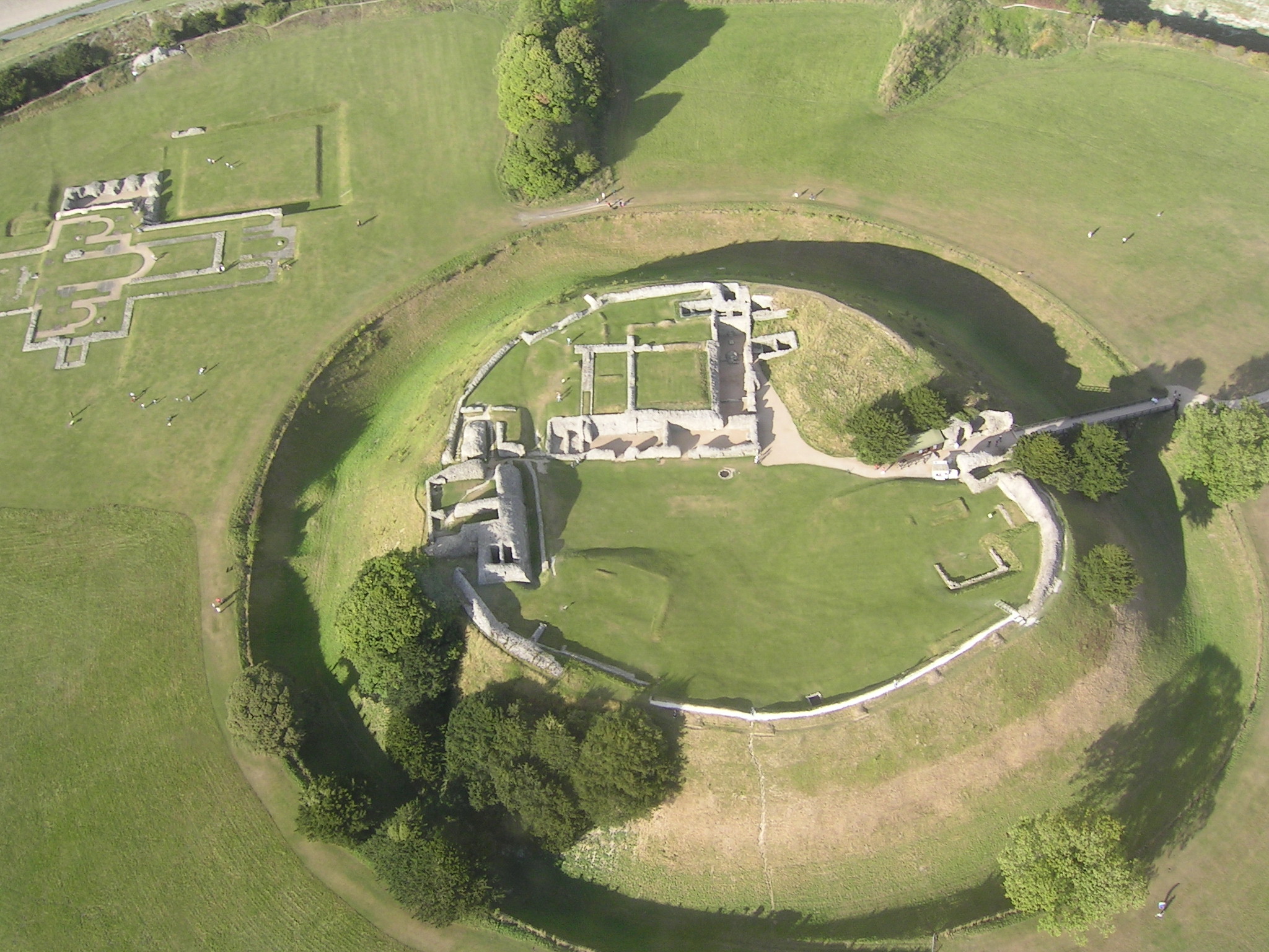
Old Sarum Castle

Old Sarum Castle, formerly known as Seresberi Castle, is an 11th century motte-and-bailey castle built in Old Sarum, Wiltshire. It was originally built...
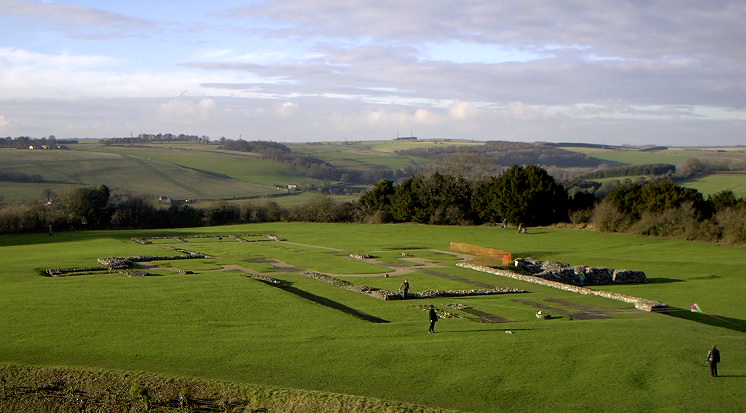
Old Sarum Cathedral

Old Sarum Cathedral was a Catholic and Norman cathedral at old Salisbury, now known as Old Sarum, between 1092 and 1220. Only its foundations remain, in...
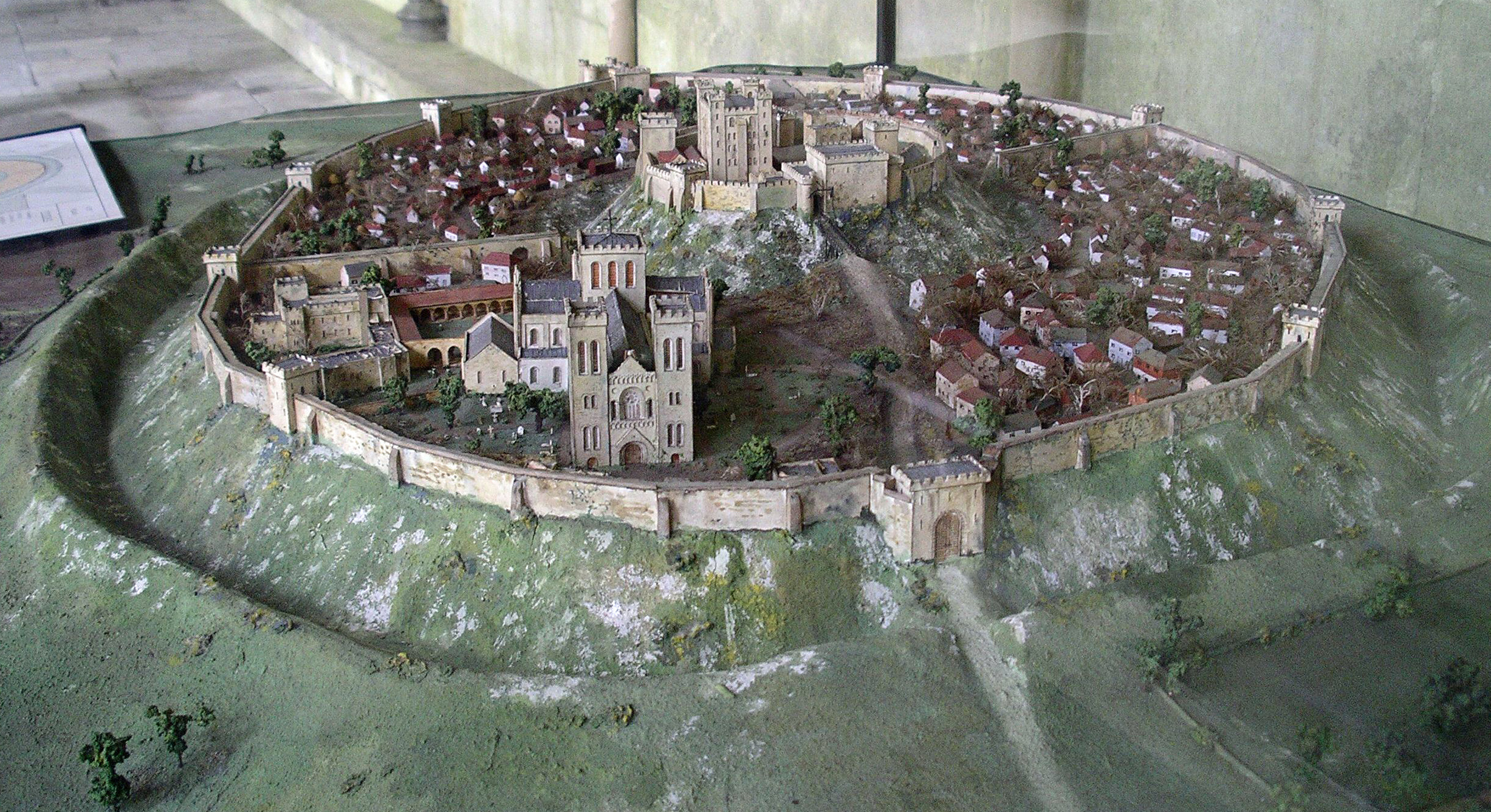
Old Sarum

Old Sarum, in Wiltshire, South West England, is the ruined and deserted site of the earliest settlement of Salisbury. Situated on a hill about two miles...

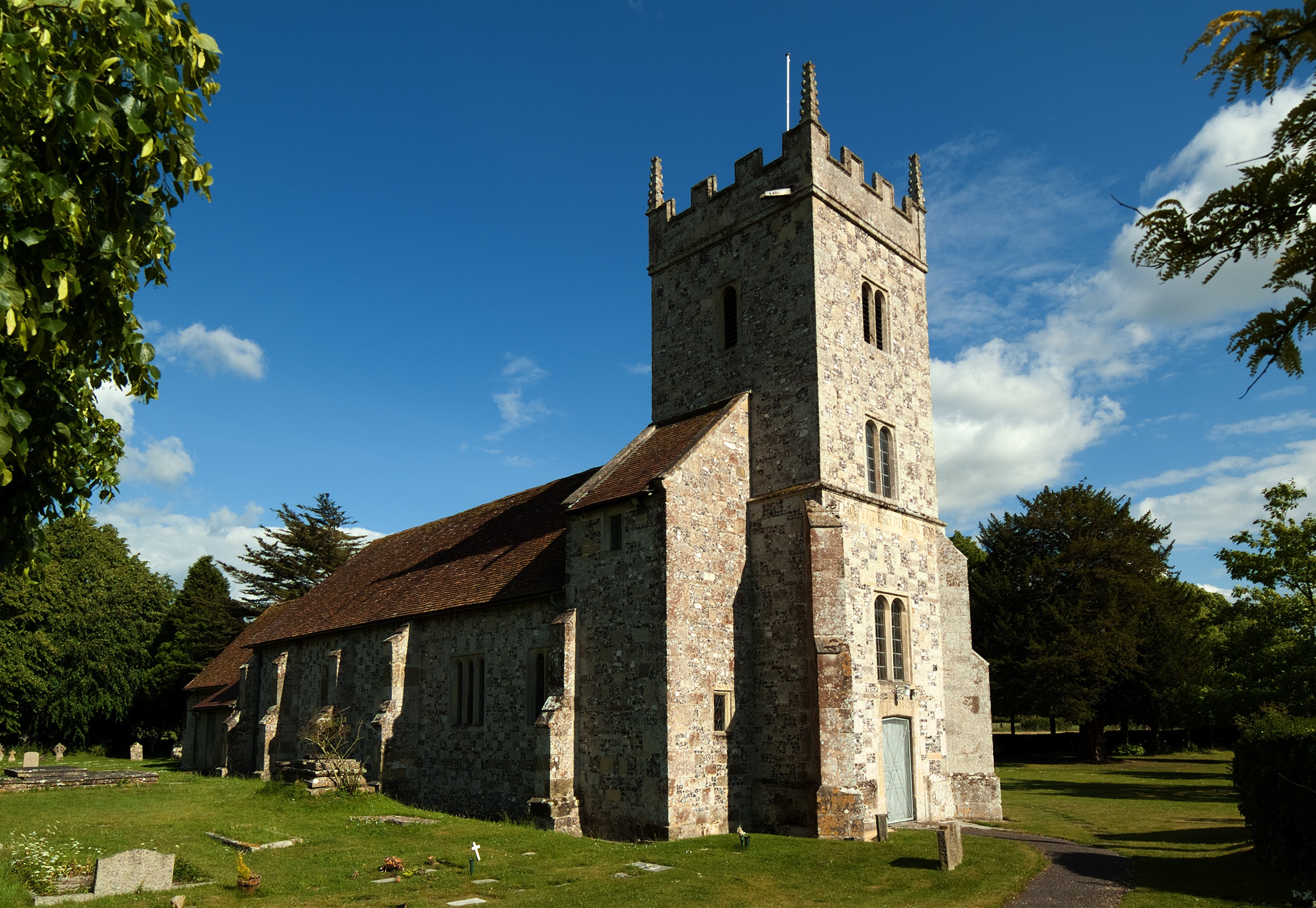
St Lawrence, Stratford-sub-Castle

St Lawrence's Church at Stratford-sub-Castle is a 13th-century Grade I listed Church of England parish church, to the north of Salisbury, Wiltshire, England...

Stratford-sub-Castle

Stratford-sub-Castle in Wiltshire, England, was anciently a separate village and civil parish, but since 1954 has been a northern suburb of the city of...

Nearby Amenities

Located within 500m of 51.102908,-1.7951972
Bus Stop
Bus: yes
Local Ref: BeeHive Park & Ride
Naptan AtcoCode: 4600WIY42944
Naptan Bearing: E
Naptan CommonName: Beehive P
Naptan Indicator: E-bound
Naptan NaptanCode: wildpjdw
Naptan Street: Salisbury Road
Public Transport: platform
Lat/Long: 51.0995355/-1.7952608
Mini Roundabout
Lat/Long: 51.1001542/-1.7898235
Barrier: bollard
Lat/Long: 51.1048338/-1.7889734
Crossing
Lat/Long: 51.1065271/-1.79099
Old Sarum Skatepark
Access: yes
Leisure: pitch
Sport: skateboard
Surface: concrete
Lat/Long: 51.1016398/-1.7929952
Social Facility
Old Sarum Manor
Operator: Elmfield Care
Operator Type: private
Social Facility: nursing_home
Social Facility For: senior
Wheelchair: yes
Lat/Long: 51.1057593/-1.7929696
Cafe
Lat/Long: 51.1063244/-1.7932941
Restaurant
Caprinos
Cuisine: pizza
Takeaway: only
Lat/Long: 51.1063454/-1.7938882
Restaurant
Mandarin House
Cuisine: chinese
Takeaway: only
Lat/Long: 51.1063766/-1.7937782
Spar
Brand: Spar
Brand Wikidata: Q610492
Operator: SPAR
Shop: convenience
Lat/Long: 51.1064524/-1.793561
Waste Basket
Waste: dog_excrement; trash
Lat/Long: 51.104668/-1.7893466
Bench
Lat/Long: 51.1064179/-1.7933032
Bicycle Parking
Lat/Long: 51.1063876/-1.7934011
Play Area
Leisure: playground
Operator: Laverstock & Ford Parish Council
Lat/Long: 51.1018036/-1.7886088
Bus Stop
Beehive Roundabout
Bus: yes
Naptan AtcoCode: 4600WIA12606
Naptan Bearing: N
Naptan CommonName: Beehive Roundabout
Naptan Indicator: N-bound
Naptan NaptanCode: wildgdgm
Naptan PlusbusZoneRef: SLSBRY
Naptan Street: A345
Naptan Verified: no
Public Transport: platform
Shelter: yes
Source: mapilary;naptan;bing;naptan_compare_tool
Lat/Long: 51.0986403/-1.7967482
The data included in this document is from www.openstreetmap.org. The data is made available under ODbL.

Have you been to Rockshill Plantation?

Leave your review of Rockshill Plantation below (or comments, questions and feedback).