Guards Wood

Wood, Forest in Durham

England

Guards Wood

Turkey Muck, Labourn's Fell By product of industrial poultry raising being used as fertiliser. There is a danger however of heavy metal contamination, I have experienced problems with copper.
Turkey Muck, Labourn's Fell Credit: Richard Webb

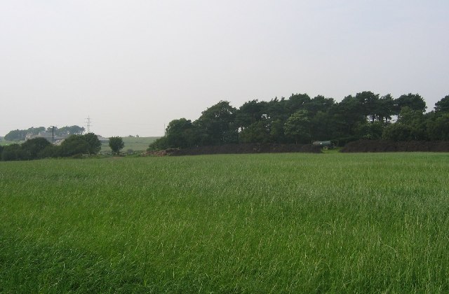
Guards Wood, located in Durham, England, is a picturesque forest that spans approximately 200 acres. The wood is nestled in the heart of the North Pennines Area of Outstanding Natural Beauty, offering visitors a tranquil and immersive experience in nature. The forest primarily consists of a mix of native broadleaf trees, including oak, birch, and beech, which create a stunning canopy of foliage throughout the year.

The wood is renowned for its diverse wildlife, making it a popular destination for nature enthusiasts and birdwatchers. Visitors can expect to encounter an array of bird species, such as woodpeckers, buzzards, and owls, as well as small mammals like deer, squirrels, and foxes. The forest floor is carpeted with a rich variety of wildflowers, further enhancing the beauty of the landscape.

Several well-maintained walking trails meander through Guards Wood, offering visitors the opportunity to explore its natural wonders. The trails vary in difficulty, catering to both casual walkers and more experienced hikers. Along the way, informative signposts provide interesting facts about the wood's flora and fauna, adding an educational element to the experience.

In addition to its natural beauty, Guards Wood also boasts a picnic area and a small visitor center. The visitor center offers information about the wood's history and conservation efforts, as well as maps and guides for visitors to plan their exploration. Overall, Guards Wood is a serene and enchanting destination that allows visitors to escape the hustle and bustle of everyday life and immerse themselves in the wonders of nature.

If you have any feedback on the listing, please let us know in the comments section below.

Guards Wood Images

Images are sourced within 2km of 54.942565/-1.8253566 or Grid Reference NZ1160. Thanks to Geograph Open Source API. All images are credited.

Turkey Muck, Labourn's Fell By product of industrial poultry raising being used as fertiliser. There is a danger however of heavy metal contamination, I have experienced problems with copper.
Turkey Muck, Labourn's Fell
By product of industrial poultry raising being used as fertiliser. There is a danger however of heavy metal contamination, I have experienced problems with copper.
Northumbria Gliding Club Situated high on the ridge between the Derwent valley and Tynedale. <span class="nowrap"><a title="https://www.northumbriagliding.co.uk/" rel="nofollow ugc noopener" href="https://www.northumbriagliding.co.uk/">Link</a><img style="margin-left:2px;" alt="External link" title="External link - shift click to open in new window" src="https://s1.geograph.org.uk/img/external.png" width="10" height="10"/></span>
Northumbria Gliding Club
Situated high on the ridge between the Derwent valley and Tynedale. LinkExternal link
Leadgate A tiny hamlet high on the ridge between the Derwent valley and Tynedale. Not to be confused with the much larger Leadgate village at <a href="https://www.geograph.org.uk/gridref/NZ1251">NZ1251</a>.
Leadgate
A tiny hamlet high on the ridge between the Derwent valley and Tynedale. Not to be confused with the much larger Leadgate village at NZ1251.
Agricultural graveyard, Leadgate
Agricultural bric-a-brac A mess like this is too frequent a sight in the countryside.
Agricultural bric-a-brac
A mess like this is too frequent a sight in the countryside.
Building near Horse Gate Farm This concrete building looks as if it dates from WW2. Purpose unknown.
Building near Horse Gate Farm
This concrete building looks as if it dates from WW2. Purpose unknown.
Garesfield Golf Club The course dates back to 1922 and is dramatically situated high above the Derwent valley. <span class="nowrap"><a title="http://www.garesfieldgolf.com/" rel="nofollow ugc noopener" href="http://www.garesfieldgolf.com/">Link</a><img style="margin-left:2px;" alt="External link" title="External link - shift click to open in new window" src="https://s1.geograph.org.uk/img/external.png" width="10" height="10"/></span>
Garesfield Golf Club
The course dates back to 1922 and is dramatically situated high above the Derwent valley. LinkExternal link
Horse Gate Farm
Horse Gate Farm
Durham Riding
Durham Riding
Hyons East Wood Hyons East Wood, taken from the junction of the byway and the bridleway.
Hyons East Wood
Hyons East Wood, taken from the junction of the byway and the bridleway.
Farmland between Durham Riding and Hyons Wood
Looking over towards Leadgate View of the Hamlet from Greenhead Road.
Looking over towards Leadgate
View of the Hamlet from Greenhead Road.
Old farm at Leadgate This old farmhouse in the tiny hamlet of Leadgate has obviously seen better days. Which is a shame because it looks very old and is of the longhouse type with the farmhouse at one end and accommodation for the beasts at the other.
Old farm at Leadgate
This old farmhouse in the tiny hamlet of Leadgate has obviously seen better days. Which is a shame because it looks very old and is of the longhouse type with the farmhouse at one end and accommodation for the beasts at the other.
W T masts These twin relay masts are at the top of Greenhead Road above Chopwell. They stand right on the ridge line between the Tyne and Derwent valleys at 840 ft, and form a very prominent landmark.
W T masts
These twin relay masts are at the top of Greenhead Road above Chopwell. They stand right on the ridge line between the Tyne and Derwent valleys at 840 ft, and form a very prominent landmark.
Currock Hill Farm Situated prominently on the ridge top beside the road from the hamlet of Leadgate and the village of Hedley on the hill.
Currock Hill Farm
Situated prominently on the ridge top beside the road from the hamlet of Leadgate and the village of Hedley on the hill.
Dead trees This is Leadgate Plantation, where there obviously been a lot of tree felling lately. Don't know why these have been left. There are tremendous views of the Tyne valley from this ridge top.
Dead trees
This is Leadgate Plantation, where there obviously been a lot of tree felling lately. Don't know why these have been left. There are tremendous views of the Tyne valley from this ridge top.
Looking back East Looking along the lane towards Leadgate, from the minor road leading down to Bowser's Hole.
Looking back East
Looking along the lane towards Leadgate, from the minor road leading down to Bowser's Hole.
Junction of Lead Road and Greenhead Road Left for Chopwell, right for Leadgate.
Junction of Lead Road and Greenhead Road
Left for Chopwell, right for Leadgate.
Show me another place!

Guards Wood is located at Grid Ref: NZ1160 (Lat: 54.942565, Lng: -1.8253566)

Unitary Authority: Gateshead

Police Authority: Northumbria

What 3 Words

///gangway.secrets.inherits. Near Chopwell, Tyne & Wear

Nearby Locations

Clinty Wood Guards Wood

Related Wikis

Leadgate, Northumberland

Leadgate is a hamlet just outside Chopwell in southern Northumberland, England. It is 4.5 miles (7.3 km) southeast of Stocksfield and 1 mile (1.8 km) northwest...

Currock Hill

Currock Hill is a hill in Tyne and Wear, England, which at 259 m (850 ft) is the highest point in the county, and in the metropolitan borough of Gateshead...

Prudhoe Community High School

Prudhoe Community High School is a coeducational high school and sixth form located in Prudhoe, Northumberland, England. Situated on Moor Road, Prudhoe...

Chopwell Colliery

Chopwell Colliery was a coal mine situated at Chopwell, in Gateshead, Tyne and Wear. The pit was first sunk in 1781, and was closed on 25 November 1966...

Prudhoe

Prudhoe ( PRUD-ə) is a town in south Northumberland, England, about 11 miles (18 km) west of the city of Newcastle upon Tyne and just south of the River...

Chopwell

Chopwell is a village in the Gateshead district, in the county of Tyne and Wear, England, 3 miles (4.8 km) west of Rowlands Gill and 1 mile (1.6 km) north...

Prudhoe Town F.C.

Prudhoe Town Football Club was a football club based in Prudhoe, Northumberland, England. The club is affiliated to the Northumberland Football Association...

Prudhoe Youth Club F.C.

Prudhoe Youth Club Football Club is a football club based in Prudhoe, England. They are currently members of the Northern League Division Two and play...

Nearby Amenities

Located within 500m of 54.942565,-1.8253566
Guards
Place: locality
Lat/Long: 54.944518/-1.8250639
Power: pole
Lat/Long: 54.9432031/-1.8183438
Power: pole
Lat/Long: 54.9448051/-1.8187852
Power: pole
Lat/Long: 54.9440088/-1.8185713
Power: pole
Lat/Long: 54.9435253/-1.8184347
Power: pole
Lat/Long: 54.9418559/-1.8177949
Power: pole
Lat/Long: 54.9429399/-1.8189027
Power: pole
Lat/Long: 54.9436512/-1.8190275
Power: pole
Lat/Long: 54.9445401/-1.8191866
Ford: yes
Lat/Long: 54.9459686/-1.8298985
The data included in this document is from www.openstreetmap.org. The data is made available under ODbL.

Have you been to Guards Wood?

Leave your review of Guards Wood below (or comments, questions and feedback).