Clapgate Spring Plantation
Wood, Forest in Yorkshire Richmondshire
England
Clapgate Spring Plantation
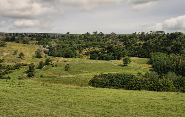
Clapgate Spring Plantation, located in Yorkshire, is a picturesque woodland area known for its rich biodiversity and natural beauty. This enchanting forest spans across a vast area, offering visitors an opportunity to immerse themselves in the tranquility of nature.
The plantation is home to a diverse range of trees, including oak, beech, birch, and ash. These towering giants form a dense canopy, providing shade and shelter for various plant species that thrive in the understory. The forest floor is adorned with a vibrant carpet of wildflowers, ferns, and mosses, creating a magical atmosphere.
Clapgate Spring Plantation is not only a haven for plant life but also serves as a habitat for numerous animal species. The woodland is teeming with wildlife, including deer, foxes, squirrels, and a wide variety of bird species. Birdwatchers will be delighted to spot woodpeckers, owls, and various songbirds that call this forest their home.
The plantation offers a network of well-maintained trails, allowing visitors to explore its natural wonders. Hiking through the forest, one can discover hidden streams, tranquil ponds, and charming picnic spots. The plantation is also a popular destination for nature photography enthusiasts due to its stunning vistas and abundant wildlife.
In addition to its natural beauty, Clapgate Spring Plantation is committed to conservation and sustainable practices. The land is carefully managed to preserve its ecological integrity, and efforts are made to educate visitors about the importance of protecting and respecting this delicate ecosystem.
Overall, Clapgate Spring Plantation in Yorkshire is a sanctuary of natural splendor, providing a serene and captivating experience for all who visit.
If you have any feedback on the listing, please let us know in the comments section below.
Clapgate Spring Plantation Images
Images are sourced within 2km of 54.414077/-1.8309659 or Grid Reference NZ1102. Thanks to Geograph Open Source API. All images are credited.
![Bridleway through Clints Wood Bridleway through woodland above Marske Beck. The mature tree on the left is of interest as it is an elm, a rare sight these days. [presumed to be a wych elm]](https://s2.geograph.org.uk/geophotos/04/57/84/4578410_b43e096b.jpg)


![Orgate Farm The approach to the farm along the bridleway from Marske. One wonders if the name has anything to do with the mining and transportation of lead ore [galena] which was mined nearby and once smelted at furnaces in the valley below.](https://s0.geograph.org.uk/geophotos/04/57/84/4578432_abd2b304.jpg)


Clapgate Spring Plantation is located at Grid Ref: NZ1102 (Lat: 54.414077, Lng: -1.8309659)
Division: North Riding
Administrative County: North Yorkshire
District: Richmondshire
Police Authority: North Yorkshire
What 3 Words
///before.retiring.stun. Near Richmond, North Yorkshire
Nearby Locations
Related Wikis

Scott Trial
The Scott Trial is a British motorcycle trials competition dating from 1914 run over an off-road course of approximately 70 miles (110 km). One of the...

Marske, west North Yorkshire
Marske is a village and civil parish in the Richmondshire district of North Yorkshire, England, situated in lower Swaledale on the boundary of the Yorkshire...

Applegarth, North Yorkshire
Applegarth is a historic settlement located north of the River Swale in Yorkshire, England. It lies about three-quarters of a mile north-east of the village...

Skelton, west North Yorkshire
Skelton is a small hamlet in the Richmondshire district of North Yorkshire, England. It is within the Yorkshire Dales National Park near the larger village...
Nearby Amenities
Located within 500m of 54.414077,-1.8309659Have you been to Clapgate Spring Plantation?
Leave your review of Clapgate Spring Plantation below (or comments, questions and feedback).