Howpit Wood

Wood, Forest in Yorkshire Richmondshire

England

Howpit Wood

Stile near Downholme Bridge The stile gives walkers access to the footpath that takes them initially beside the River Swale before heading west towards Cat Bank and Marske.
Stile near Downholme Bridge Credit: Maigheach-gheal

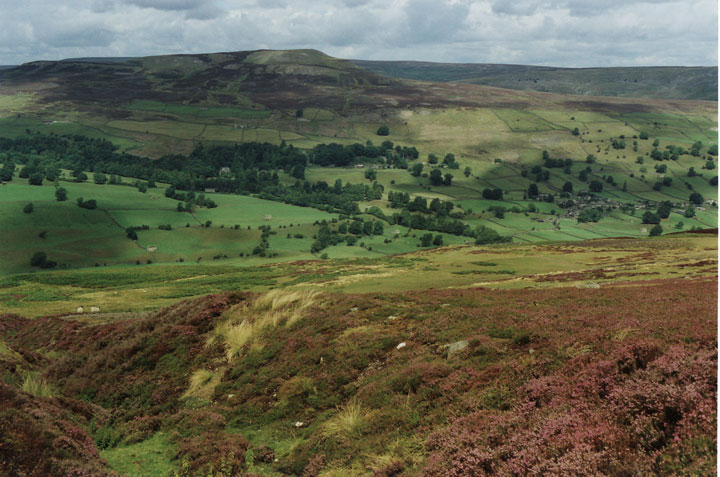
Howpit Wood is a picturesque woodland area located in Yorkshire, England. Situated amidst the rolling hills and valleys of the region, it covers an approximate area of 100 acres. The wood is predominantly made up of a variety of deciduous trees, including oak, beech, and birch, which create a beautiful and vibrant landscape throughout the seasons.

The wood is known for its tranquil and serene atmosphere, making it a popular destination for nature enthusiasts, hikers, and photographers. Its well-maintained pathways and trails provide ample opportunities for visitors to explore the area and immerse themselves in the natural beauty that surrounds them.

Wildlife thrives in Howpit Wood, with a range of animals and birds calling it home. Visitors may spot deer, foxes, rabbits, and a variety of bird species as they wander through the wood. This makes it an ideal location for wildlife enthusiasts and birdwatchers to observe and appreciate the diversity of the area.

Howpit Wood also boasts a rich historical significance, with evidence of human activity dating back centuries. The wood is believed to have been used as a hunting ground by the local nobility during the medieval period, and remnants of ancient structures can still be found within its boundaries.

Overall, Howpit Wood is a treasure trove of natural beauty, providing a haven for flora and fauna, as well as a peaceful retreat for those seeking solace in the great outdoors. Its combination of stunning scenery, diverse wildlife, and historical significance make it a must-visit destination for anyone exploring Yorkshire's natural wonders.

If you have any feedback on the listing, please let us know in the comments section below.
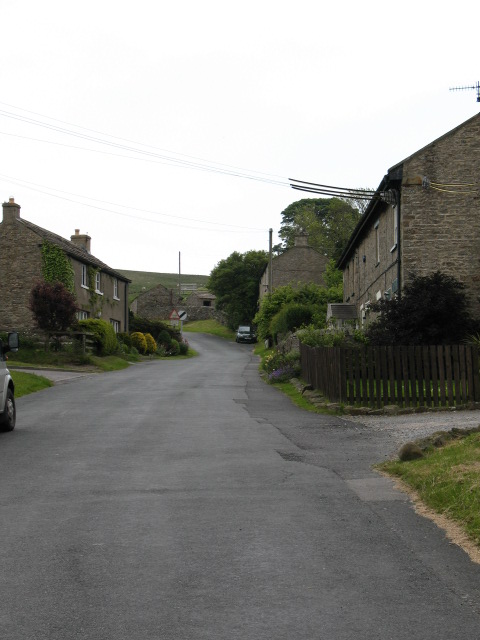
Howpit Wood Images

Images are sourced within 2km of 54.377876/-1.8363179 or Grid Reference SE1098. Thanks to Geograph Open Source API. All images are credited.

Stile near Downholme Bridge The stile gives walkers access to the footpath that takes them initially beside the River Swale before heading west towards Cat Bank and Marske.
Stile near Downholme Bridge
The stile gives walkers access to the footpath that takes them initially beside the River Swale before heading west towards Cat Bank and Marske.
Downholme Bridge Late 17th century, Grade II listed bridge.  It is built of rubble with ashlar dressings.
Downholme Bridge
Late 17th century, Grade II listed bridge. It is built of rubble with ashlar dressings.
River Swale, Downholme Looking upstream from Downholme Bridge.

The River Swale is the northernmost tributary of the Yorkshire Ouse with its headwaters located in the eastern Yorkshire Dales, from where it flows in an easterly direction towards Richmond.
River Swale, Downholme
Looking upstream from Downholme Bridge. The River Swale is the northernmost tributary of the Yorkshire Ouse with its headwaters located in the eastern Yorkshire Dales, from where it flows in an easterly direction towards Richmond.
River Swale, Downholme Looking downstream from Downholme Bridge.
 
The River Swale is the northernmost tributary of the Yorkshire Ouse with its headwaters located in the eastern Yorkshire Dales, from where it flows in an easterly direction towards Richmond.
River Swale, Downholme
Looking downstream from Downholme Bridge. The River Swale is the northernmost tributary of the Yorkshire Ouse with its headwaters located in the eastern Yorkshire Dales, from where it flows in an easterly direction towards Richmond.
Grazing land, Downholme The field is currently being grazed by sheep, although cattle have also grazed the field recently.  The hay crib is designed to take large round bales.
Grazing land, Downholme
The field is currently being grazed by sheep, although cattle have also grazed the field recently. The hay crib is designed to take large round bales.
Bridleway to Hollins Farm The bridleway heads across grazing fields towards Hollins Farm which is about 1 mile away. Ewes and lambs graze this field.
Bridleway to Hollins Farm
The bridleway heads across grazing fields towards Hollins Farm which is about 1 mile away. Ewes and lambs graze this field.
Footpath near Marske The footpath crosses this small field as it takes walkers towards Low Hollins and Hollins Farm.
Footpath near Marske
The footpath crosses this small field as it takes walkers towards Low Hollins and Hollins Farm.
Gate over the hedge, Marske When the gate is fully open it swings over the dividing hedge of the fields.  The fields are at present being grazed by ewes and lambs.
Gate over the hedge, Marske
When the gate is fully open it swings over the dividing hedge of the fields. The fields are at present being grazed by ewes and lambs.
A6108 near Downholme Church
View of Lower Swaledale The picture was taken close to a newly constructed viewing point on the road which crosses Ministry of Defence land on Downholme Moor.
View of Lower Swaledale
The picture was taken close to a newly constructed viewing point on the road which crosses Ministry of Defence land on Downholme Moor.
Downholme Village Minor roads entering the village from the A6108
Downholme Village
Minor roads entering the village from the A6108
A6108, Downholme village
Cattle Grid, Coldstorms Farm Track leading from A6108 Walburnhead to the farm.
Cattle Grid, Coldstorms Farm
Track leading from A6108 Walburnhead to the farm.
Walburnhead, A6108 Near track to Coldstorms Farm.
Walburnhead, A6108
Near track to Coldstorms Farm.
Fields near Downholme View across sheep grazing land with Gill Beck on the immediate left leading to Swaledale.
Fields near Downholme
View across sheep grazing land with Gill Beck on the immediate left leading to Swaledale.
St. Michael and All Angels Church Near Downholme.
St. Michael and All Angels Church
Near Downholme.
Mole Hills near Downholme Side Bank Wood in the sun.
Mole Hills near Downholme
Side Bank Wood in the sun.
Large Lay by on A6108 Just north of Downholme Bridge
Large Lay by on A6108
Just north of Downholme Bridge
Show me another place!

Howpit Wood is located at Grid Ref: SE1098 (Lat: 54.377876, Lng: -1.8363179)

Division: North Riding

Administrative County: North Yorkshire

District: Richmondshire

Police Authority: North Yorkshire

What 3 Words

///lush.dissolves.divides. Near Richmond, North Yorkshire

Related Wikis

Downholme

Downholme is a village and civil parish in North Yorkshire, England. It is situated approximately 4 miles (6 km) west from the market town of Richmond...

Stainton, west North Yorkshire

Stainton is a hamlet and civil parish in the North Yorkshire district of North Yorkshire, England. It is located just outside the Yorkshire Dales National...

Swaledale

Swaledale is a valley in North Yorkshire, England. It is one of the Yorkshire Dales, which are part of the Pennines, and within the Yorkshire Dales National...

Marske, west North Yorkshire

Marske is a village and civil parish in the Richmondshire district of North Yorkshire, England, situated in lower Swaledale on the boundary of the Yorkshire...

Nearby Amenities

Located within 500m of 54.377876,-1.8363179
How Hill
Natural: peak
Source: OS 1:25k
Lat/Long: 54.3774845/-1.8350323
Board Type: welcome_sign
Information: board
Inscription: Welcome to Downholme
Tourism: information
Lat/Long: 54.3761333/-1.82968
Bus Stop
Downholme
Bus: yes
Departures Board: no
Physically Present: no
Public Transport: platform
Shelter: no
Source: survey
Lat/Long: 54.3762596/-1.8297966
Bus Stop
Downholme
Bus: yes
Departures Board: no
Physically Present: no
Public Transport: platform
Shelter: no
Source: survey
Lat/Long: 54.3761905/-1.829678
The data included in this document is from www.openstreetmap.org. The data is made available under ODbL.

Have you been to Howpit Wood?

Leave your review of Howpit Wood below (or comments, questions and feedback).