Cwm, Y

Settlement in Flintshire

Wales

Cwm, Y

Approaching the summit of Moel Hiraddug near Dyserth This path leads all the way to the summit from the south.
Approaching the summit of Moel Hiraddug near Dyserth Credit: Colin Park

Cwm, Y is a small village located in Flintshire, Wales. It is situated near the border with England, approximately 3 miles east of the town of Mold. The village is surrounded by picturesque countryside, with rolling hills and farmland dominating the landscape.

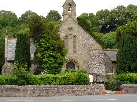
Cwm, Y has a small population of around 300 residents, many of whom are employed in agriculture or commute to nearby towns for work. The village has a primary school, a community center, and a few local shops and pubs. There is also a church that dates back to the 12th century, adding to the historical charm of the area.

The village is well-connected by road, with the A5119 passing through Cwm, Y, providing easy access to neighboring towns and cities. The nearby Clwydian Range Area of Outstanding Natural Beauty offers plenty of opportunities for outdoor activities such as hiking, cycling, and birdwatching.

Overall, Cwm, Y is a quiet and picturesque village that is perfect for those looking to escape the hustle and bustle of city life and enjoy the beauty of the Welsh countryside.

If you have any feedback on the listing, please let us know in the comments section below.

Cwm, Y Images

Images are sourced within 2km of 53.281611/-3.4113273 or Grid Reference SJ0677. Thanks to Geograph Open Source API. All images are credited.

Approaching the summit of Moel Hiraddug near Dyserth This path leads all the way to the summit from the south.
Approaching the summit of Moel Hiraddug near Dyserth
This path leads all the way to the summit from the south.
On the summit of  Moel Hiraddug with view towards Mynydd y Cwm
On the summit of Moel Hiraddug with view towards Mynydd y Cwm
Dyserth from Moel Hiraddug
Vale of Clwyd from Moel Hiraddug
The village church at Cwm near Dyserth
Plas yn Cwm near Rhuallt
On the Offa's Dyke Path north of Tyddyn-y-cyll with view to Gop Hill
Rhes o goed pinwydd / A row of pine trees These pine trees mark the southern boundary of Rhyl Rugby Club's grounds.
Rhes o goed pinwydd / A row of pine trees
These pine trees mark the southern boundary of Rhyl Rugby Club's grounds.
Hen offer amaethyddol / An old agricultural implement
Cae indrawn / A maize field
Giat cae / A field gate The hill in the background is Moel Hiraddug.
Giat cae / A field gate
The hill in the background is Moel Hiraddug.
Blwch Post Sioraidd / A Georgian Postbox
Clytwaith o gaeau Dyffryn Clwyd / A patchwork of fields in the Vale of Clwyd
Tan-y-Bryn
Tan-y-Bryn
Ty Ucha
Ty Ucha
Tombstone of Grace Williams (d. 1642) An elaborate hooded tomb.
Tombstone of Grace Williams (d. 1642)
An elaborate hooded tomb.
Mynydd y Cwm in Coed Cwm Walked up from east on good tract from forest road and as Des Taylor says the cairn looks chair like. You need to do this hill with neighbouring HUMP to see what the view could look like, Moel Maenefa.

Name: Mynydd y Cwm
Hill number: 2051
Height: 304.8m / 1000ft
Area: 30C: Llandudno to Wrexham
Class: Ma
Grid ref: SJ 07307 76735
Summit feature: ground 6m E of cairn
Drop: 150m
Col: 154.8m  SJ 17432 67786
Mynydd y Cwm in Coed Cwm
Walked up from east on good tract from forest road and as Des Taylor says the cairn looks chair like. You need to do this hill with neighbouring HUMP to see what the view could look like, Moel Maenefa. Name: Mynydd y Cwm Hill number: 2051 Height: 304.8m / 1000ft Area: 30C: Llandudno to Wrexham Class: Ma Grid ref: SJ 07307 76735 Summit feature: ground 6m E of cairn Drop: 150m Col: 154.8m SJ 17432 67786
View over the Vale of Clwyd A telephoto view over the Vale of Clwyd just south of Cwm, looking towards Rhuddlan, its castle prominent to the left. The redundant Skytower on Rhyl seafront can also be seen.
View over the Vale of Clwyd
A telephoto view over the Vale of Clwyd just south of Cwm, looking towards Rhuddlan, its castle prominent to the left. The redundant Skytower on Rhyl seafront can also be seen.
Show me another place!

Cwm, Y is located at Grid Ref: SJ0677 (Lat: 53.281611, Lng: -3.4113273)

Unitary Authority: Denbighshire

Police Authority: North Wales

Also known as: Cwm

What 3 Words

///equal.crank.mows. Near Cwm, Denbighshire

Related Wikis

Cwm, Denbighshire

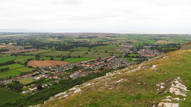
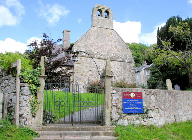
Cwm is a village and community in Denbighshire, below the hill Mynydd y Cwm. The church in Cwm is dedicated to two 6th-century saints, St Mael and St Sulien...

Moel Hiraddug

Moel Hiraddug, also known as Y Foel, is a hill fort and hill in the Clwydian Range of north-east Wales. The northern part of the hill has been eaten away...

Mynydd y Cwm

Mynydd y Cwm is a hill in the Clwydian Range in Denbighshire, North Wales. It reaches a height of 304.8 metres (1,000 feet). It has recently been promoted...

Dyserth

Dyserth (Welsh: Diserth) is a village, community and electoral ward in Denbighshire, Wales. Its population at the 2011 United Kingdom census was 2,269...

Nearby Amenities

Located within 500m of 53.281611,-3.4113273
Cwm
Place: village
Population: 378
Wikidata: Q16896555
Lat/Long: 53.2847015/-3.4058688
Power: pole
Lat/Long: 53.2852432/-3.4081335
Power: pole
Lat/Long: 53.2844028/-3.4070115
Power: pole
Lat/Long: 53.2833108/-3.4062546
Power: pole
Lat/Long: 53.2827612/-3.4059521
Power: pole
Lat/Long: 53.2821248/-3.4055804
Power: pole
Lat/Long: 53.2815288/-3.4052576
Power: pole
Lat/Long: 53.2810085/-3.4049366
Power: pole
Lat/Long: 53.2838829/-3.4065753
Power: pole
Lat/Long: 53.2849208/-3.4074222
Power: pole
Lat/Long: 53.2852345/-3.411249
Power: pole
Lat/Long: 53.2853032/-3.4103804
Power: pole
Lat/Long: 53.2853694/-3.4097332
Power: pole
Lat/Long: 53.2854241/-3.4091691
Power: pole
Lat/Long: 53.2851327/-3.4116322
Power: pole
Lat/Long: 53.2849164/-3.4064685
Direction: 165
Generator Method: photovoltaic
Generator Output Electricity: yes
Generator Solar Modules: 12
Generator Source: solar
Generator Type: solar_photovoltaic_panel
Location: roof
Power: generator
Lat/Long: 53.285096/-3.4066047
Post Box
Collection Times: Mo-Fr 10:00; Sa 09:00
Operator: Royal Mail
Post Box Type: wall
Ref: LL18 129
Royal Cypher: GR
Royal Cypher Wikidata: Q33102273
Lat/Long: 53.2851453/-3.4070077
Bus Stop
Bus: yes
Naptan AtcoCode: 5110WDB48444
Naptan NaptanCode: dbgjmja
Public Transport: platform
Lat/Long: 53.2851319/-3.4069981
The data included in this document is from www.openstreetmap.org. The data is made available under ODbL.

Have you been to Cwm, Y?

Leave your review of Cwm, Y below (or comments, questions and feedback).