Taylor's Plantation

Wood, Forest in Northumberland

England

Taylor's Plantation

Hepburn Moor, Northumberland Looking northwest over moorland on Hepburn Moor, in the distance the hill of Ros Castle can be seen.
Hepburn Moor, Northumberland Credit: Rebecca A Wills

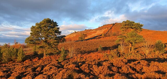
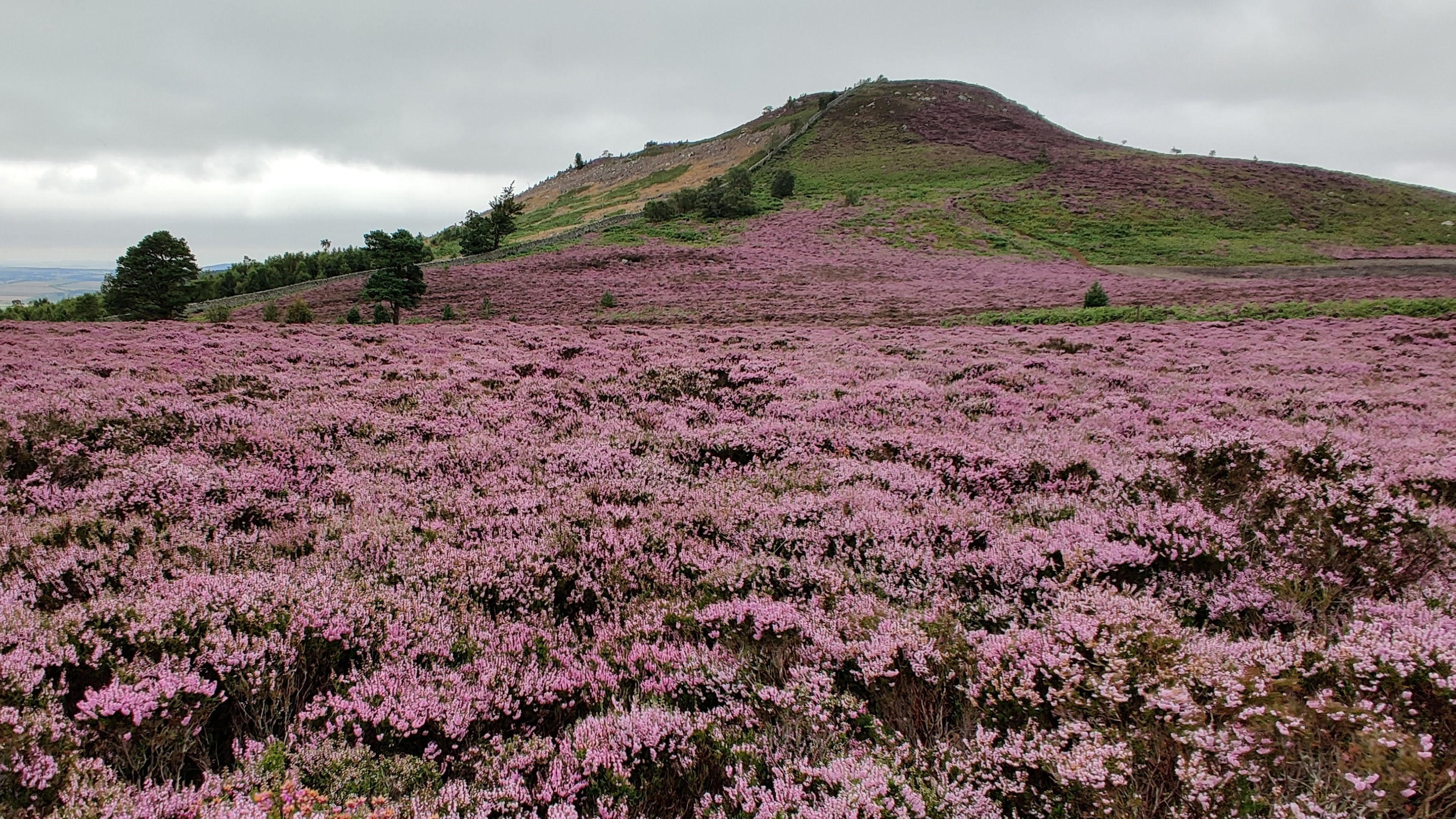
Taylor's Plantation is a picturesque woodland area located in Northumberland, England. Covering an expansive area, it is a popular destination for nature enthusiasts and locals alike. The plantation is known for its dense forest, comprising various species of trees, including oak, birch, and pine.

One of the standout features of Taylor's Plantation is its well-maintained walking trails that wind through the woodland. These paths provide visitors with the opportunity to explore the plantation's natural beauty at their own pace. The trails are suitable for all levels of fitness and are often used by hikers, joggers, and families looking for a peaceful outdoor experience.

The plantation is also home to a diverse range of wildlife, making it a haven for nature lovers. Birdwatchers can spot a variety of species, including woodpeckers, owls, and various migratory birds. Additionally, small mammals such as squirrels and rabbits can often be seen darting through the undergrowth.

In addition to its natural beauty, Taylor's Plantation boasts several amenities for visitors. There are picnic areas scattered throughout the plantation, allowing visitors to relax and enjoy a meal amidst the tranquil surroundings. The plantation also offers educational programs and guided tours, providing visitors with insights into the local flora and fauna.

Overall, Taylor's Plantation in Northumberland offers a serene and scenic escape from the hustle and bustle of everyday life. Whether it's exploring the woodland trails, observing the diverse wildlife, or simply enjoying a peaceful picnic, the plantation provides a memorable experience for nature lovers of all ages.

If you have any feedback on the listing, please let us know in the comments section below.

Taylor's Plantation Images

Images are sourced within 2km of 55.527519/-1.8814841 or Grid Reference NU0725. Thanks to Geograph Open Source API. All images are credited.

Hepburn Moor, Northumberland Looking northwest over moorland on Hepburn Moor, in the distance the hill of Ros Castle can be seen.
Hepburn Moor, Northumberland
Looking northwest over moorland on Hepburn Moor, in the distance the hill of Ros Castle can be seen.
Hepburn Moor, Northumberland Looking south over Hepburn Moor.
Hepburn Moor, Northumberland
Looking south over Hepburn Moor.
Hepburn Moor, Northumberland A view across Hepburn Moor, with Ros Castle in the distance.
Hepburn Moor, Northumberland
A view across Hepburn Moor, with Ros Castle in the distance.
Hepburn Moor, Northumberland Looking over moorland towards Ros Castle in the distance.
Hepburn Moor, Northumberland
Looking over moorland towards Ros Castle in the distance.
Hepburn Moor, Northumberland Looking towards Chillingham from the vicinity of Ros Castle.
Hepburn Moor, Northumberland
Looking towards Chillingham from the vicinity of Ros Castle.
Hepburn, Northumberland Looking southwest over farmland in the vicinity of Hepburn.
Hepburn, Northumberland
Looking southwest over farmland in the vicinity of Hepburn.
Hepburn Farm, Northumberland Looking south, as the sun was setting, over farmland in the vicinity of Hepburn Farm.
Hepburn Farm, Northumberland
Looking south, as the sun was setting, over farmland in the vicinity of Hepburn Farm.
Hepburn Moor, Northumberland Looking over moorland on Hepburn Moor. Ros Castle can be seen in the distance.
Hepburn Moor, Northumberland
Looking over moorland on Hepburn Moor. Ros Castle can be seen in the distance.
Ros Castle, Northumberland Looking north up a track leading up the southern edge of Ros Castle.
Ros Castle, Northumberland
Looking north up a track leading up the southern edge of Ros Castle.
Hepburn Moor On the horizon, the brooding mass of the Cheviot <a href="https://www.geograph.org.uk/gridref/NT9020">NT9020</a>.
Hepburn Moor
On the horizon, the brooding mass of the Cheviot NT9020.
The road over Hepburn Moor
Ros Castle Commanding hill overlooking the valley of the River Till, in the ownership of the National Trust.
Ros Castle
Commanding hill overlooking the valley of the River Till, in the ownership of the National Trust.
Trig pillar on Ros Castle The plaque reads:
Ros Castle Camp
This height with its wide prospect was a favourite resort of 
Sir Edward Grey afterwards Viscount Grey of Fallodon KG
Foreign Secretary December 1905 to December 1916.
In 1956 it was presented to the National Trust as part of a National Memorial to him.

The wall behind is part of the extensive wall surrounding the Chillingham estate.
Trig pillar on Ros Castle
The plaque reads: Ros Castle Camp This height with its wide prospect was a favourite resort of Sir Edward Grey afterwards Viscount Grey of Fallodon KG Foreign Secretary December 1905 to December 1916. In 1956 it was presented to the National Trust as part of a National Memorial to him. The wall behind is part of the extensive wall surrounding the Chillingham estate.
Walk-in toposcope on Ros Castle Ros Castle hilltop is the site of an Iron Age hillfort. The toposcope was erected by the YHA. A trig pillar with commemorative plaque <a href="https://www.geograph.org.uk/photo/7156968">NU0825 : Trig pillar on Ros Castle</a> to the left.  The wall is part of the boundary wall of the Chillingham Castle estate.
Walk-in toposcope on Ros Castle
Ros Castle hilltop is the site of an Iron Age hillfort. The toposcope was erected by the YHA. A trig pillar with commemorative plaque NU0825 : Trig pillar on Ros Castle to the left. The wall is part of the boundary wall of the Chillingham Castle estate.
View  eastwards from Ros Castle An extensive view of moorland and forest. In the middle distance, the 20.5 MW capacity Wandylaw Wind Farm <a href="https://www.geograph.org.uk/gridref/NU1224">NU1224</a>, commissioned in 2013 with ten turbines.
View eastwards from Ros Castle
An extensive view of moorland and forest. In the middle distance, the 20.5 MW capacity Wandylaw Wind Farm NU1224, commissioned in 2013 with ten turbines.
The steep path down from Ros Castle A solitary pine tree stands beside the path.
The steep path down from Ros Castle
A solitary pine tree stands beside the path.
Boundary wall of  the Chillingham Castle estate Looking north-east from the summit of Ros Castle
Boundary wall of the Chillingham Castle estate
Looking north-east from the summit of Ros Castle
Boundary wall of the Chillingham Castle estate Looking south-west from the summit of Ros Castle. Trig pillar in the foreground.
Boundary wall of the Chillingham Castle estate
Looking south-west from the summit of Ros Castle. Trig pillar in the foreground.
Show me another place!

Taylor's Plantation is located at Grid Ref: NU0725 (Lat: 55.527519, Lng: -1.8814841)

Unitary Authority: Northumberland

Police Authority: Northumbria

What 3 Words

///spooned.asterisk.solves. Near Wooler, Northumberland

Related Wikis

Chillingham cattle

Chillingham cattle, also known as Chillingham wild cattle, is a breed of cattle that live in a large enclosed park at Chillingham Castle, Northumberland...

Ros Hill

Ros Hill, also known as Ros Castle due to the 3,000-year-old Iron Age hill fort on its summit, is a hill in the county of Northumberland in northern England...

Chillingham, Northumberland

Chillingham is a village in Northumberland, England. It is situated approximately 6 km (3.7 mi) to the east of Wooler, south of Chatton. At the 2011 Census...
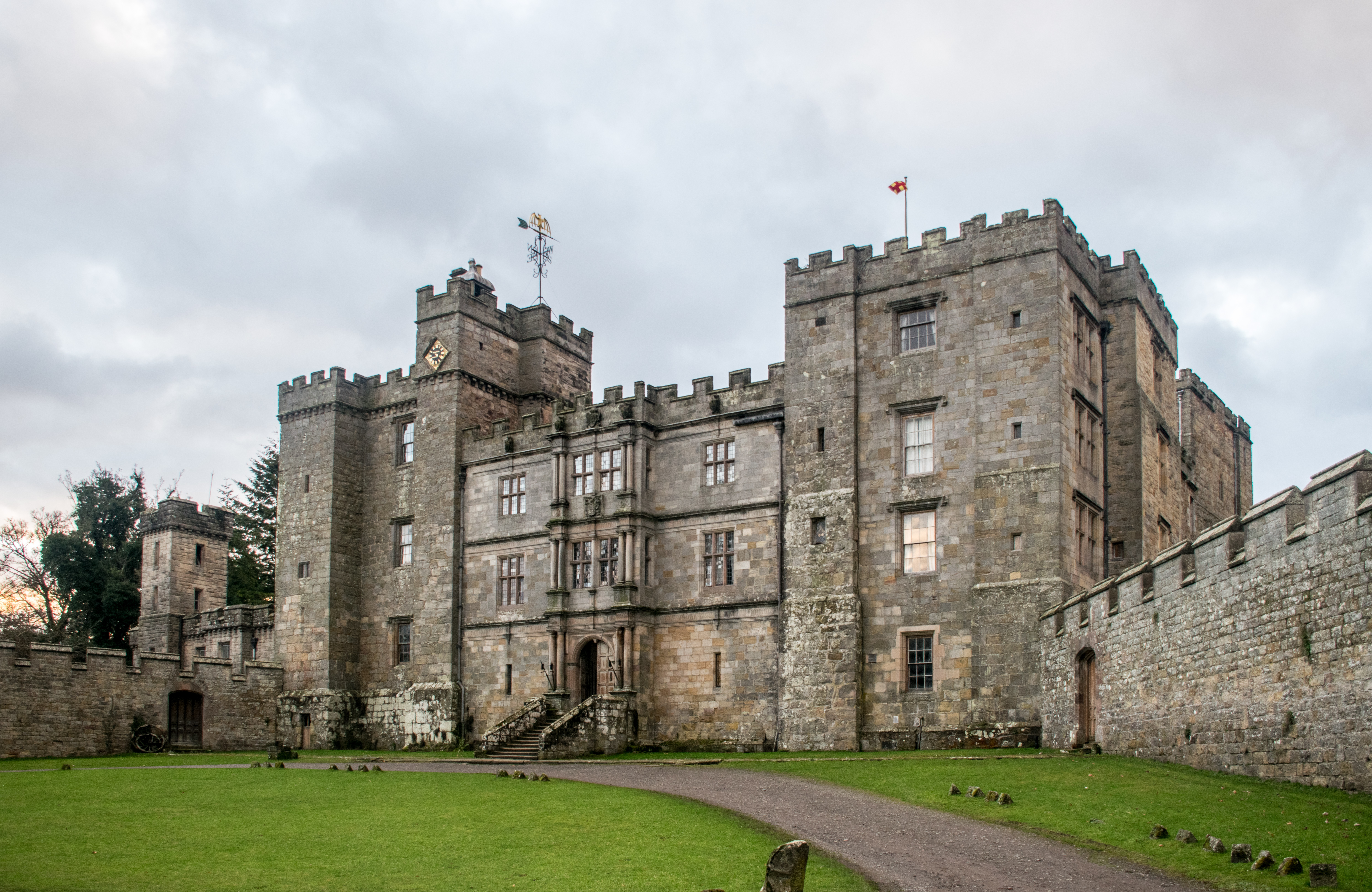
Chillingham Castle

Chillingham Castle is a medieval castle in the village of Chillingham in the northern part of Northumberland, England. It was the seat of the Grey and...

Nearby Amenities

Located within 500m of 55.527519,-1.8814841
Robin Hood's Bog
Place: locality
Lat/Long: 55.5283336/-1.8745949
Chillingham Wood
Place: locality
Lat/Long: 55.5314447/-1.8817372
Chillingham Park
Place: locality
Lat/Long: 55.5261376/-1.8873277
Hart Plantation
Place: locality
Lat/Long: 55.5261201/-1.8824693
My Lord's Plantation
Place: locality
Lat/Long: 55.5272195/-1.8850288
The data included in this document is from www.openstreetmap.org. The data is made available under ODbL.

Have you been to Taylor's Plantation?

Leave your review of Taylor's Plantation below (or comments, questions and feedback).