Blackburn Wood

Wood, Forest in Durham

England

Blackburn Wood

The Lodge of St. John's Hall South of the Weardale village of Wolsingham a 'dead end' road gives an approach to several isolated buildings. The grandest of them is St. John's Hall, presently (April 2011) unoccupied and deteriorating <a title="https://www.geograph.org.uk/photo/1781360" href="https://www.geograph.org.uk/photo/1781360">Link</a>. This bungalow is the lodge for the hall; it's also unoccupied and is deteriorating as well.
The Lodge of St. John's Hall Credit: Trevor Littlewood

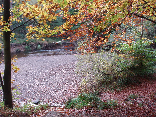
Blackburn Wood is a dense forest located in the county of Durham, England. Covering an area of approximately 500 acres, it is a popular destination for nature enthusiasts and hikers. The wood is situated near the village of Blackburn and is easily accessible by car or public transportation.

The forest encompasses a diverse range of flora and fauna, providing a rich ecosystem for various species. Towering oak and beech trees dominate the landscape, creating a majestic canopy that offers shelter and shade to a myriad of smaller plants and animals. Bluebells, primroses, and wild garlic add splashes of color to the forest floor during springtime.

Blackburn Wood is crisscrossed by numerous walking trails, allowing visitors to explore its beauty at their own pace. These well-maintained paths offer different levels of difficulty, catering to both casual walkers and experienced hikers. Along the way, visitors may encounter charming streams, picturesque ponds, and the occasional glimpse of wildlife such as deer, squirrels, and various bird species.

The wood is also home to a small visitor center, where visitors can obtain information about the forest's history, geology, and wildlife. The center offers guided tours and educational programs for schools and groups, aiming to raise awareness about the importance of conservation and sustainable forest management.

Overall, Blackburn Wood is a serene and captivating natural haven, providing a tranquil escape from the hustle and bustle of everyday life. It offers an opportunity to reconnect with nature and enjoy the beauty of the Durham countryside.

If you have any feedback on the listing, please let us know in the comments section below.

Blackburn Wood Images

Images are sourced within 2km of 54.700138/-1.8864942 or Grid Reference NZ0733. Thanks to Geograph Open Source API. All images are credited.

The Lodge of St. John's Hall South of the Weardale village of Wolsingham a 'dead end' road gives an approach to several isolated buildings. The grandest of them is St. John's Hall, presently (April 2011) unoccupied and deteriorating <a title="https://www.geograph.org.uk/photo/1781360" href="https://www.geograph.org.uk/photo/1781360">Link</a>. This bungalow is the lodge for the hall; it's also unoccupied and is deteriorating as well.
The Lodge of St. John's Hall
South of the Weardale village of Wolsingham a 'dead end' road gives an approach to several isolated buildings. The grandest of them is St. John's Hall, presently (April 2011) unoccupied and deteriorating Link. This bungalow is the lodge for the hall; it's also unoccupied and is deteriorating as well.
West Moor Plantation West Moor Plantation lies adjacent to moorland and to the north-east of Hamsterley Forest.
West Moor Plantation
West Moor Plantation lies adjacent to moorland and to the north-east of Hamsterley Forest.
Black Allotment Track near leading past Black Allotment and Harthope.
Black Allotment
Track near leading past Black Allotment and Harthope.
Harthope Track above Ashes Allotment.
Harthope
Track above Ashes Allotment.
Ruddy Carr Ruddy Carr seen from near Harthope.
Ruddy Carr
Ruddy Carr seen from near Harthope.
Wear Lane Quarry Communications mast above Wolsingham.
Wear Lane Quarry
Communications mast above Wolsingham.
View West up the Dale Looking up Weardale from the road to the South of Wolsingham.
View West up the Dale
Looking up Weardale from the road to the South of Wolsingham.
Road Junction Junction of the road running South from Wolsingham with the minor road which leads to Doctor's Gate.
Road Junction
Junction of the road running South from Wolsingham with the minor road which leads to Doctor's Gate.
View West from the Hamsterley road Wiserley Barn Plantation on the left.
View West from the Hamsterley road
Wiserley Barn Plantation on the left.
Valley of the Harthope Beck Looking across the little valley from the Hmasterley road.
Valley of the Harthope Beck
Looking across the little valley from the Hmasterley road.
Wiserley Barn Plantation Looking across from the Hamsterley road to the plantation and Dryderdale beyond.
Wiserley Barn Plantation
Looking across from the Hamsterley road to the plantation and Dryderdale beyond.
Roadside trees at Knitsley Cottage An isolated house beside Dryderdale Plantation.
Roadside trees at Knitsley Cottage
An isolated house beside Dryderdale Plantation.
Dryderdale Plantation There has evidently been a lot of clear felling going on recently.
Dryderdale Plantation
There has evidently been a lot of clear felling going on recently.
Dryderdale Farm Big old farm in Dryderdale. Looks to be late eighteenth century possibly, but I don't know for certain.
Dryderdale Farm
Big old farm in Dryderdale. Looks to be late eighteenth century possibly, but I don't know for certain.
Looking along Stanhope Lane This track runs along the South side of West Moor Plantation. At its Western end it leads out onto open moorland.
Looking along Stanhope Lane
This track runs along the South side of West Moor Plantation. At its Western end it leads out onto open moorland.
View East from Cabin Hill Looking over the open moor towards Dryderdale.
View East from Cabin Hill
Looking over the open moor towards Dryderdale.
Looking towards Doctor's Gate View across the open moor from Cabin Hill.
Looking towards Doctor's Gate
View across the open moor from Cabin Hill.
Looking West from near Blackburn Lodge View from the road North of the Lodge. St John's Hall in the distance.
Looking West from near Blackburn Lodge
View from the road North of the Lodge. St John's Hall in the distance.
Show me another place!

Blackburn Wood is located at Grid Ref: NZ0733 (Lat: 54.700138, Lng: -1.8864942)

Unitary Authority: County Durham

Police Authority: Durham

What 3 Words

///drift.spill.mega. Near Wolsingham, Co. Durham

Related Wikis

Low Redford Meadows

Low Redford Meadows is a Site of Special Scientific Interest in the Teesdale district of County Durham, England. It consists of two separate areas of meadows...

Weardale

Weardale is a dale, or valley, on the east side of the Pennines in County Durham, England. Large parts of Weardale fall within the North Pennines Area...

Wear Valley

Wear Valley was, from 1974 to 2009, a local government district in County Durham, England. Its council and district capital was Crook. The district covered...

Wolsingham

Wolsingham is a market town in Weardale, County Durham, England. It is situated by the River Wear, between Crook and Stanhope. == History == Wolsingham...

Bedburn

Bedburn is a village in County Durham, in England. It is in the civil parish of South Bedburn, near Hamsterley, and Hamsterley Forest. The Bedburn Beck...

South Bedburn

South Bedburn is a civil parish in County Durham, England. The population of the civil parish at the 2011 census was 171. == References == == External... ==

Frog Wood Bog

Frog Wood Bog is a Site of Special Scientific Interest in the Teesdale district of County Durham, England. It lies alongside Bedburn Beck, approximately...

Wolsingham School

Wolsingham School is a coeducational secondary school located in Wolsingham, County Durham, England.The school is situated just off the A689, and near...

Nearby Amenities

Located within 500m of 54.700138,-1.8864942
Power: pole
Lat/Long: 54.7021675/-1.891762
Power: pole
Lat/Long: 54.700685/-1.8939936
Power: pole
Lat/Long: 54.7013143/-1.8935484
Power: pole
Lat/Long: 54.7018963/-1.893146
Power: pole
Lat/Long: 54.7026921/-1.8925868
The data included in this document is from www.openstreetmap.org. The data is made available under ODbL.

Have you been to Blackburn Wood?

Leave your review of Blackburn Wood below (or comments, questions and feedback).