Hamwoods Copse

Wood, Forest in Dorset

England

Hamwoods Copse

Old railway bridge over Mannington Brook, West Moors This image, taken in February 2016, updates one I took in 2011. In that year, the bridge was heavily obscured by vegetation and rather neglected: the owners of the land (and the bridge) have now cleared the undergrowth - and coupled to a fine flow of water down the brook (flowing towards the viewer), and no leaves on the trees in the foreground, this makes quite a pleasing shot.
Old railway bridge over Mannington Brook, West Moors Credit: Martin Rowley

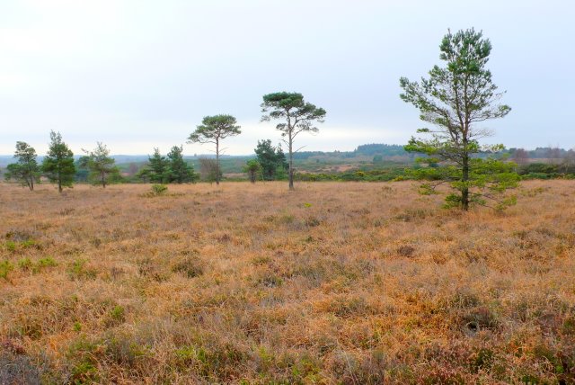
Hamwoods Copse is a picturesque woodland located in the county of Dorset, England. Covering an area of approximately 50 acres, it is a haven for nature enthusiasts and provides a tranquil escape from the bustling city life. The copse is situated on the outskirts of the small village of Hamwoods, which is surrounded by rolling countryside and scenic landscapes.

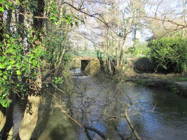
The woodland itself is predominantly composed of native broadleaf trees, including oak, beech, and ash. These trees create a dense canopy, allowing only dappled sunlight to filter through to the forest floor. This creates a cool and shaded environment, perfect for a leisurely walk or a picnic on a sunny day.

Hamwoods Copse is home to a diverse array of wildlife, including numerous bird species such as woodpeckers, owls, and finches. Small mammals like rabbits, foxes, and squirrels can also be spotted scurrying through the undergrowth. The copse is known for its rich biodiversity and is an important habitat for various insect species, including butterflies and beetles.

The woodland is crisscrossed by a network of footpaths, making it easily accessible for visitors. These paths wind their way through the woods, leading to secluded clearings and hidden ponds. There are also several benches strategically placed along the trails, providing a perfect spot to rest and take in the natural beauty of the surroundings.

Hamwoods Copse is a popular destination for nature walks, photography, and birdwatching. Its peaceful ambiance and natural charm make it a beloved spot for locals and tourists alike, seeking a retreat into the heart of nature.

If you have any feedback on the listing, please let us know in the comments section below.

Hamwoods Copse Images

Images are sourced within 2km of 50.822075/-1.9045901 or Grid Reference SU0602. Thanks to Geograph Open Source API. All images are credited.

Old railway bridge over Mannington Brook, West Moors This image, taken in February 2016, updates one I took in 2011. In that year, the bridge was heavily obscured by vegetation and rather neglected: the owners of the land (and the bridge) have now cleared the undergrowth - and coupled to a fine flow of water down the brook (flowing towards the viewer), and no leaves on the trees in the foreground, this makes quite a pleasing shot.
Old railway bridge over Mannington Brook, West Moors
This image, taken in February 2016, updates one I took in 2011. In that year, the bridge was heavily obscured by vegetation and rather neglected: the owners of the land (and the bridge) have now cleared the undergrowth - and coupled to a fine flow of water down the brook (flowing towards the viewer), and no leaves on the trees in the foreground, this makes quite a pleasing shot.
Ferndown Industrial Estate Rebuilding fire-damaged warehousing on the Ferndown Industrial Estate.
Ferndown Industrial Estate
Rebuilding fire-damaged warehousing on the Ferndown Industrial Estate.
St George's Playing Field This field lays at the heart of a zone of education, leisure and sports facilities.
St George's Playing Field
This field lays at the heart of a zone of education, leisure and sports facilities.
St George's Playing Field This playing field is surrounded by schools, a leisure centre, sports and play facilities and further playing fields.
St George's Playing Field
This playing field is surrounded by schools, a leisure centre, sports and play facilities and further playing fields.
Cobham Road, Ferndown Industrial Estate A grey road, on a grey day.
Cobham Road, Ferndown Industrial Estate
A grey road, on a grey day.
Bramley Road, Ferndown
Roundabout on the A31, Ferndown
Heathlands Lodge, Ferndown
Kia Motors on Wimborne Road East
Bungalow on West Moors Road, Ferndown
Signs on the A31, Ferndown
Roundabout on the A31, Ferndown
The A31, Ameysford
The A31, Ameysford
Old Milepost by Wimborne Road East, west of Ferndown Cast iron post by the UC road, in parish of FERNDOWN TOWN (EAST DORSET District), Wimborne Road, by No. 414, by the road, on South side of road. Ringwood cast iron post (Trust), erected by the Ringwood, Longham & Leigh turnpike trust in the 19th century. 

Inscription reads:- : 3 / WIM- / BORNE : : RINGW'D / TRUST : : 6 / RING- / WOOD :   

Milestone Society National ID: DO_WBRW03
Old Milepost by Wimborne Road East, west of Ferndown
Cast iron post by the UC road, in parish of FERNDOWN TOWN (EAST DORSET District), Wimborne Road, by No. 414, by the road, on South side of road. Ringwood cast iron post (Trust), erected by the Ringwood, Longham & Leigh turnpike trust in the 19th century. Inscription reads:- : 3 / WIM- / BORNE : : RINGW'D / TRUST : : 6 / RING- / WOOD : Milestone Society National ID: DO_WBRW03
Old Milepost by Wimborne Road East, Ferndown Cast iron post by the UC road, in parish of FERNDOWN TOWN (EAST DORSET District), Ferdown, 30m East of Monkton Close; 50m East of traffic lights, by the road, on South side of road. Ringwood cast iron post (Trust), erected by the Ringwood, Longham & Leigh turnpike trust in the 19th century. 

Inscription reads:- : 4 / WIM- / BORNE : : RINGW'D / TRUST : : 5 / RING- / WOOD : 

Milestone Society National ID: DO_WBRW04
Old Milepost by Wimborne Road East, Ferndown
Cast iron post by the UC road, in parish of FERNDOWN TOWN (EAST DORSET District), Ferdown, 30m East of Monkton Close; 50m East of traffic lights, by the road, on South side of road. Ringwood cast iron post (Trust), erected by the Ringwood, Longham & Leigh turnpike trust in the 19th century. Inscription reads:- : 4 / WIM- / BORNE : : RINGW'D / TRUST : : 5 / RING- / WOOD : Milestone Society National ID: DO_WBRW04
Ashurst Road A narrow fairly leafy residential road in West Moors.
Ashurst Road
A narrow fairly leafy residential road in West Moors.
The Avenue A leafy residential road in West Moors.
The Avenue
A leafy residential road in West Moors.
Show me another place!

Hamwoods Copse is located at Grid Ref: SU0602 (Lat: 50.822075, Lng: -1.9045901)

Unitary Authority: Dorset

Police Authority: Dorset

What 3 Words

///shed.works.plank. Near Ferndown, Dorset

Related Wikis

West Moors

West Moors is a village in Dorset, England, on the northern fringe of the Poole-Bournemouth conurbation, just outside the larger settlements of Ferndown...

West Moors railway station

West Moors is a closed railway station in Dorset. Opened in 1867, it became the junction of the Southampton and Dorchester Railway and the Salisbury and...

Ferndown

Ferndown is a town and civil parish in Dorset in southern England, immediately to the north of Bournemouth and Poole. The parish, which until 1972 was...

Ameysford

Ameysford is a village in Dorset, England. There is an electoral ward of the same name which is a suburb of Ferndown.

Ferndown Upper School

Ferndown Upper School is a comprehensive school and sixth form located in Ferndown, Dorset. Opened in 1972, it has grown to accommodate a broad and successful...

Holt Heath, Dorset

Holt Heath is a 4.88 square kilometres (1.88 sq mi) common situated four miles north-east of Wimborne Minster in east Dorset, southern England, close to...

Trickett's Cross

Trickett's Cross is an estate situated on the outskirts of Ferndown, Dorset, England. It lies at the junction of two primary routes, the A31 road and A348...

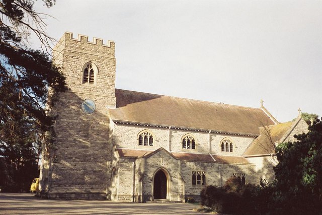
St Mary's Church, Ferndown

St Mary's Church is a Church of England parish church in the town of Ferndown, Dorset. == History == Building of the nave began in 1933, on land given...

Nearby Amenities

Located within 500m of 50.822075,-1.9045901
Crossing
Lat/Long: 50.8195562/-1.9020754
Power: tower
Source: Bing
Lat/Long: 50.8236511/-1.9016863
Power: tower
Source: Bing
Lat/Long: 50.8213958/-1.9026277
Power: tower
Source: Bing
Lat/Long: 50.8197623/-1.903309
Power: tower
Source: Bing
Lat/Long: 50.8181085/-1.9048459
Power: tower
Source: Bing
Lat/Long: 50.8190015/-1.9035371
Power: tower
Source: Bing
Lat/Long: 50.8216686/-1.9014879
Power: pole
Lat/Long: 50.8202511/-1.9044699
Power: pole
Lat/Long: 50.8195869/-1.9058003
Power: pole
Lat/Long: 50.8216121/-1.9033411
Power: pole
Lat/Long: 50.8232048/-1.9032338
Power: pole
Lat/Long: 50.8242994/-1.9031533
Power: pole
Lat/Long: 50.8254041/-1.9030836
Ameysford
Place: village
Source: OS OpenData StreetView
Wikidata: Q4745971
Wikipedia: en:Ameysford
Lat/Long: 50.8188761/-1.9008118
Bicycle Rental
Ferndown Forest Golf Club
Bicycle Rental: dropoff_point
Capacity: 8
Email: support@beryl.cc
Fee: yes
Name Signed: no
Network: Beryl - Bournemouth Poole Christchurch
Official Name: Ferndown Forest Golf Club
Operator: Beryl
Operator Wikidata: Q106575369
Payment App: yes
Payment App Android: cc.beryl.basis
Payment App Ios: 1386768364
Payment Cash: no
Payment Credit Cards: no
Payment Cryptocurrencies: no
Payment Debit Cards: no
Payment Electronic Purses: no
Phone: +44 20 3003 5044
Ref Gbfs: beryl_bcp:3997
Rental: city_bike
Website: https://beryl.cc/scheme/bournemouth-christchurch-and-poole
Lat/Long: 50.821252/-1.900315
The data included in this document is from www.openstreetmap.org. The data is made available under ODbL.

Have you been to Hamwoods Copse?

Leave your review of Hamwoods Copse below (or comments, questions and feedback).