Cummingston

Settlement in Morayshire

Scotland

Cummingston

Harbour Entrance From the end of the north sea wall, looking shorewards with the west sea wall in the foreground.
Harbour Entrance Credit: Anne Burgess

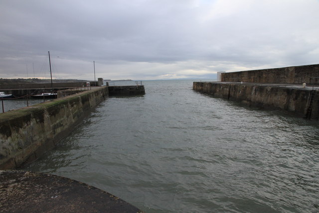
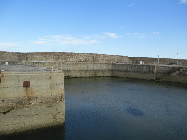
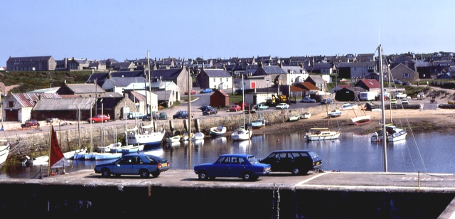
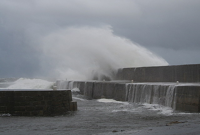
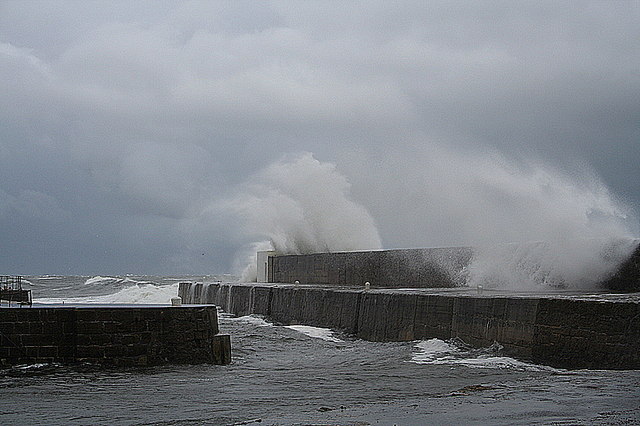
Cummingston is a small coastal village located in Morayshire, Scotland. Situated along the Moray Firth, Cummingston offers stunning views of the North Sea and easy access to nearby sandy beaches. The village is known for its picturesque cliffs and rock formations, making it a popular destination for outdoor enthusiasts and nature lovers.

Cummingston is a quiet and peaceful community, with a small population of residents who enjoy the tranquil atmosphere and close-knit feel of the village. The village has a rich history, with evidence of ancient settlements dating back to the Bronze Age.

While Cummingston is primarily a residential area, there are a few amenities available to residents and visitors, including a local pub and a small convenience store. The village is also conveniently located near larger towns such as Elgin, making it easy to access additional services and amenities.

Overall, Cummingston is a charming and picturesque village that offers a peaceful retreat for those looking to escape the hustle and bustle of city life and enjoy the beauty of the Scottish coast.

If you have any feedback on the listing, please let us know in the comments section below.

Cummingston Images

Images are sourced within 2km of 57.701761/-3.4587224 or Grid Reference NJ1368. Thanks to Geograph Open Source API. All images are credited.

Harbour Entrance From the end of the north sea wall, looking shorewards with the west sea wall in the foreground.
Harbour Entrance
From the end of the north sea wall, looking shorewards with the west sea wall in the foreground.
Getting Afloat A group of wetsuit-clad people with paddleboards and inflatables in the calm waters of Hopeman harbour.
Getting Afloat
A group of wetsuit-clad people with paddleboards and inflatables in the calm waters of Hopeman harbour.
Harbour Wall Hopeman harbour breakwater looking west.
Harbour Wall
Hopeman harbour breakwater looking west.
Moray Firth The Moray Firth from Hopeman harbour mouth.
Moray Firth
The Moray Firth from Hopeman harbour mouth.
Harbour Pier The northern wall of Hopeman Harbour.
Harbour Pier
The northern wall of Hopeman Harbour.
Westerly view as we approach Hopeman harbour A quick snapshot taken over the starboard bow as I track south for Hopeman harbour in the last of the evening light. That's the Burghead maltings which you see in the distance.
Westerly view as we approach Hopeman harbour
A quick snapshot taken over the starboard bow as I track south for Hopeman harbour in the last of the evening light. That's the Burghead maltings which you see in the distance.
Fishing from the end of the harbour Sea anglers were trying their luck at Hopeman Harbour.
Fishing from the end of the harbour
Sea anglers were trying their luck at Hopeman Harbour.
Hopeman Harbour Sea anglers were at the west end of the harbour.
Hopeman Harbour
Sea anglers were at the west end of the harbour.
Entrance to Hopeman Harbour
The Ballan Wrasse (Labrus bergylta) This is one of our most colourful species in the waters around Great Britain. There are five species of wrasse to be found around these islands but the only other one that I have caught to date is the Cuckoo Wrasse. Armed with canine teeth these fish live on molluscs and can even dislodge and chomp the limpet. This fish can live for twenty to thirty years. After capture this specimen was returned to the Moray Firth. The heaviest Ballan Wrasse caught in the UK waters weighed in at around 9 pounds.<a href="https://www.geograph.org.uk/photo/4611155">NJ1971 : The Cuckoo Wrasse and his multi-coloured coat (Labrus mixtus)</a>
<a href="https://www.geograph.org.uk/photo/421120">NJ1870 : Barnacles on Limpets on the Covesea shoreline.</a>
The Ballan Wrasse (Labrus bergylta)
This is one of our most colourful species in the waters around Great Britain. There are five species of wrasse to be found around these islands but the only other one that I have caught to date is the Cuckoo Wrasse. Armed with canine teeth these fish live on molluscs and can even dislodge and chomp the limpet. This fish can live for twenty to thirty years. After capture this specimen was returned to the Moray Firth. The heaviest Ballan Wrasse caught in the UK waters weighed in at around 9 pounds.NJ1971 : The Cuckoo Wrasse and his multi-coloured coat (Labrus mixtus) NJ1870 : Barnacles on Limpets on the Covesea shoreline.
Hopeman harbour entrance
"Aaaaaaaaaaaaaaaaaaagh!!!!!!!!!!!!" It's cold, very cold but all five stalwarts jumped nevertheless. The water registers 5 degrees Centigrade and the Hopeman ritual has been completed for another year.
"Aaaaaaaaaaaaaaaaaaagh!!!!!!!!!!!!"
It's cold, very cold but all five stalwarts jumped nevertheless. The water registers 5 degrees Centigrade and the Hopeman ritual has been completed for another year.
"These boys are such whimps!!............" Whilst the male of the species thrashes frenziedly like the blades of a runaway turbo-prop the she of the species lingers in the 5 degree brine. Now, what does that tell you? This picture shows two of the five Hopeman Boxing day pier jumpers of 2014.
"These boys are such whimps!!............"
Whilst the male of the species thrashes frenziedly like the blades of a runaway turbo-prop the she of the species lingers in the 5 degree brine. Now, what does that tell you? This picture shows two of the five Hopeman Boxing day pier jumpers of 2014.
Hopeman Harbour Founded as a fishing port, Hopeman harbour now shelters mainly pleasure craft.
Hopeman Harbour
Founded as a fishing port, Hopeman harbour now shelters mainly pleasure craft.
Seine Net Trawler Hopeman 1958 This photo was taken by my brother in 1958 with a Brownie 125!!
Fishing as it was and not like the vast industrial ships sailing from North East ports today!
Seine Net Trawler Hopeman 1958
This photo was taken by my brother in 1958 with a Brownie 125!! Fishing as it was and not like the vast industrial ships sailing from North East ports today!
Red Sails in the Sunset off  Cummingston Just behind the red sail on the shore you can see Burghead maltings buildings.
Red Sails in the Sunset off Cummingston
Just behind the red sail on the shore you can see Burghead maltings buildings.
Smashing, dashing, restless sea - North pier at Hopeman. A wind approaching 50 mph from the north hammers Hopeman harbour in the early morning.
Smashing, dashing, restless sea - North pier at Hopeman.
A wind approaching 50 mph from the north hammers Hopeman harbour in the early morning.
Sometimes angry, sometimes............ A furious sea gives a spirited display at Hopeman.
Sometimes angry, sometimes............
A furious sea gives a spirited display at Hopeman.
Show me another place!

Cummingston is located at Grid Ref: NJ1368 (Lat: 57.701761, Lng: -3.4587224)

Unitary Authority: Moray

Police Authority: North East

Also known as: Cummingstown

What 3 Words

///reject.lofts.scoop. Near Hopeman, Moray

Related Wikis

Cummingston

Cummingston is located on the north-east coast of Scotland in Moray. It lies on the B9012, sandwiched between the two fishing villages of Hopeman and Burghead...

Burghead Transmitting Station

The Burghead transmitting station is a broadcasting facility near Burghead (grid reference NJ125685) in Scotland for long wave and medium wave radio transmission...

Hopeman railway station

Hopeman railway station served the village of Hopeman, Moray, Scotland from 1892 to 1957 on the Highland Railway's branch line from Alves. == History... ==

Hopeman

Hopeman (Scots: Houpmin, Scottish Gaelic: Hudaman) is a seaside village in Moray, Scotland, it is situated on the coast of the Moray Firth, founded in...

Nearby Amenities

Located within 500m of 57.701761,-3.4587224
Source: PGS
Lat/Long: 57.7050383/-3.4536574
Source: PGS
Lat/Long: 57.7046995/-3.4544599
Source: PGS
Lat/Long: 57.704316/-3.4554593
Source: PGS
Lat/Long: 57.7047503/-3.4568793
Source: PGS
Lat/Long: 57.7048405/-3.4570949
Source: PGS
Lat/Long: 57.7049515/-3.4572741
Source: PGS
Lat/Long: 57.7048317/-3.45759
Source: PGS
Lat/Long: 57.7047743/-3.4575815
Source: PGS
Lat/Long: 57.7042452/-3.4575992
Source: PGS
Lat/Long: 57.7039297/-3.4581522
Source: PGS
Lat/Long: 57.7038024/-3.4597208
Source: PGS
Lat/Long: 57.7037334/-3.4597562
Source: PGS
Lat/Long: 57.7036789/-3.4601446
Source: PGS
Lat/Long: 57.7036425/-3.4606043
Source: PGS
Lat/Long: 57.7036319/-3.4611037
Source: PGS
Lat/Long: 57.7038577/-3.4626487
Created By: dmgroom_coastlines
Source: PGS
Lat/Long: 57.703785/-3.464999
Source: PGS
Lat/Long: 57.703809/-3.4660997
Natural: stone
Lat/Long: 57.7038693/-3.4621898
Natural: cave_entrance
Lat/Long: 57.7036641/-3.4598326
Natural: stone
Lat/Long: 57.7037891/-3.46477
Cummingston
Name Gd: An Coileach
Name Sco: The Collach
Place: village
Wikidata: Q5194128
Wikipedia: en:Cummingston
Lat/Long: 57.7020481/-3.457833
Natural: cave_entrance
Lat/Long: 57.703924/-3.4583647
Natural: cave_entrance
Lat/Long: 57.7037971/-3.4584875
Natural: cave_entrance
Lat/Long: 57.7042768/-3.4573641
Natural: cave_entrance
Lat/Long: 57.7041069/-3.4575453
Natural: cave_entrance
Lat/Long: 57.7039634/-3.4587678
Natural: cave_entrance
Lat/Long: 57.703876/-3.4594049
Natural: cave_entrance
Lat/Long: 57.7037704/-3.4631426
Natural: cave_entrance
Lat/Long: 57.7038068/-3.4628496
Natural: cave_entrance
Lat/Long: 57.7037195/-3.4621715
Toilets
Lat/Long: 57.7030738/-3.4573767
Defibrillator
Emergency: defibrillator
Ref GB The Circuit: 39D3194E-4F39-495A-A531-397F148BBC33
Lat/Long: 57.7019328/-3.4579799
War Memorial
Historic: memorial
Lat/Long: 57.701888/-3.4582988
Post Box
Collection Times: Mo-Fr 09:00; Sa 07:00
Post Box Type: lamp
Ref: IV30 23D
Royal Cypher: scottish_crown
Lat/Long: 57.7019104/-3.4580783
Natural: cave_entrance
Lat/Long: 57.7046631/-3.4535366
Power: pole
Lat/Long: 57.7013571/-3.4643243
Power: pole
Lat/Long: 57.7015974/-3.4631284
Power: pole
Lat/Long: 57.7018277/-3.461997
Power: pole
Lat/Long: 57.7020609/-3.4608953
Power: pole
Lat/Long: 57.7022782/-3.4598636
Power: pole
Lat/Long: 57.7025834/-3.4583929
Power: pole
Lat/Long: 57.7028453/-3.4571376
Power: pole
Lat/Long: 57.7031281/-3.4557692
Power: pole
Lat/Long: 57.7033339/-3.4547806
Power: pole
Lat/Long: 57.7036585/-3.454184
Power: pole
Lat/Long: 57.70425/-3.4531429
Power: pole
Lat/Long: 57.7013348/-3.4585222
Power: pole
Lat/Long: 57.7007921/-3.4582851
Power: pole
Lat/Long: 57.700202/-3.4579915
Power: pole
Lat/Long: 57.6996032/-3.4577221
Power: pole
Lat/Long: 57.6990649/-3.4574231
Power: pole
Lat/Long: 57.6985294/-3.4571538
Power: pole
Lat/Long: 57.6978047/-3.4615041
Power: pole
Lat/Long: 57.697999/-3.4603054
Power: pole
Lat/Long: 57.6981962/-3.4591094
Power: pole
Lat/Long: 57.698361/-3.4581585
Power: pole
Lat/Long: 57.6986906/-3.4560736
Power: pole
Lat/Long: 57.698849/-3.4549988
Power: pole
Lat/Long: 57.6990131/-3.453889
Power: pole
Lat/Long: 57.6991685/-3.4527469
Playground: slide
Lat/Long: 57.7033722/-3.4575174
The data included in this document is from www.openstreetmap.org. The data is made available under ODbL.

Have you been to Cummingston?

Leave your review of Cummingston below (or comments, questions and feedback).