Cumberworth

Settlement in Lincolnshire East Lindsey

England

Cumberworth

Beck feeding into Willoughby High Drain: aerial 2023 There are tumuli marked on OS map in the pale green field, centre.
Beck feeding into Willoughby High Drain: aerial 2023 Credit: Chris

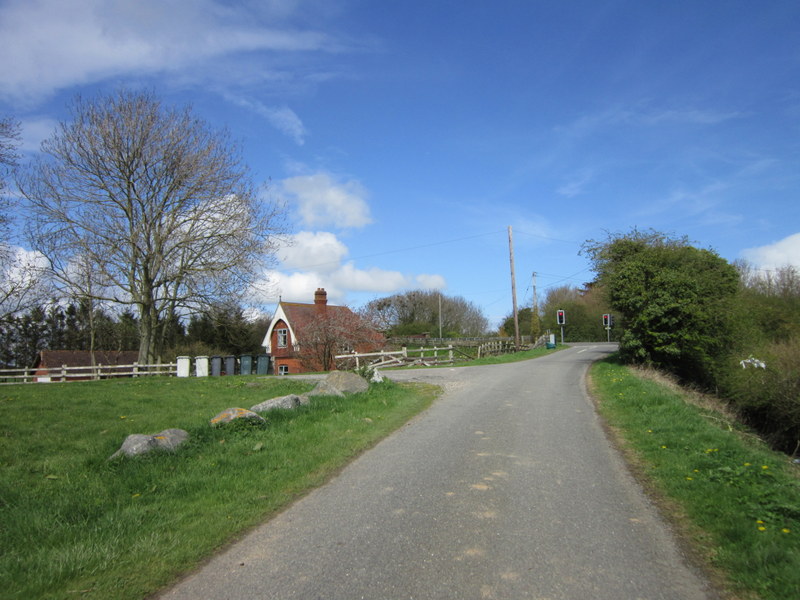
Cumberworth is a small village located in the county of Lincolnshire, in the East Midlands region of England. Situated approximately 7 miles east of the town of Louth, Cumberworth is nestled in the picturesque Lincolnshire Wolds, an Area of Outstanding Natural Beauty.

With a population of just over 200 residents, Cumberworth is a tight-knit community that exudes a serene and peaceful atmosphere. The village is characterized by its charming cottages, many of which date back to the 18th and 19th centuries, giving it a distinct historic feel.

The surrounding countryside offers breathtaking views and ample opportunities for outdoor activities, such as hiking, cycling, and horse riding. Cumberworth is also home to a number of nature reserves, providing habitats for various wildlife species.

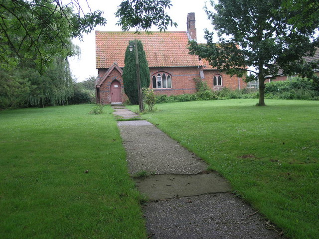
The village boasts a primary school, providing education for local children, and a village hall that serves as a hub for community gatherings and events. Additionally, Cumberworth is home to the St. Helen's Church, a beautiful medieval building that stands as a testament to the village's rich history.

Although Cumberworth is a predominantly residential area, it benefits from its proximity to nearby towns, offering easy access to amenities such as shops, supermarkets, and healthcare facilities.

Overall, Cumberworth is a tranquil and picturesque village, offering a close-knit community and idyllic countryside surroundings, making it an attractive place to live for those seeking a peaceful rural lifestyle.

If you have any feedback on the listing, please let us know in the comments section below.

Cumberworth Images

Images are sourced within 2km of 53.237345/0.255677 or Grid Reference TF5073. Thanks to Geograph Open Source API. All images are credited.

Beck feeding into Willoughby High Drain: aerial 2023 There are tumuli marked on OS map in the pale green field, centre.
Beck feeding into Willoughby High Drain: aerial 2023
There are tumuli marked on OS map in the pale green field, centre.
The Red Lion, Mumby
The Red Lion, Mumby
Cropmarks on field between Cumberworth and Bonthorpe: aerial 2023 Tree-lined Willoughby Road left.
Cropmarks on field between Cumberworth and Bonthorpe: aerial 2023
Tree-lined Willoughby Road left.
St. Thomas of Canterbury, Mumby, Lincolnshire St. Thomas of Canterbury Parish church is normally kept locked but there are 2 key-holders whose names appear on a notice board, including a map to show where they live.
St. Thomas of Canterbury, Mumby, Lincolnshire
St. Thomas of Canterbury Parish church is normally kept locked but there are 2 key-holders whose names appear on a notice board, including a map to show where they live.
Field and Cumberworth The village of Cumberworth can be seen in the distance in the next square south.
Field and Cumberworth
The village of Cumberworth can be seen in the distance in the next square south.
Hedge and Field Yet another field of this strange bean like crop.
Hedge and Field
Yet another field of this strange bean like crop.
Woods Farm I guess the Woods are not a group of trees but the family name of the farmers.
Woods Farm
I guess the Woods are not a group of trees but the family name of the farmers.
Cows and Swan The water is called Main Drain and leads to the sea via Anderby Creek pumping station. The concrete pill box shows no sign of its age.
Cows and Swan
The water is called Main Drain and leads to the sea via Anderby Creek pumping station. The concrete pill box shows no sign of its age.
Old Brick Farm This red brick farm building stands on one corner of a double bend in this narrow lane.
Old Brick Farm
This red brick farm building stands on one corner of a double bend in this narrow lane.
St.Helen's church Diminutive former parish church at Cumberworth, declared redundant in 1987 and privately owned since 1989
St.Helen's church
Diminutive former parish church at Cumberworth, declared redundant in 1987 and privately owned since 1989
Guardian angel 19th century memorial to several members of the Sylvester family, guarding the path to St.Helen's church at Cumberworth
Guardian angel
19th century memorial to several members of the Sylvester family, guarding the path to St.Helen's church at Cumberworth
St.Helen's church Deconsecrated in 1987, now privately owned
St.Helen's church
Deconsecrated in 1987, now privately owned
St.Helen's church A hotch-potch of medieval greenstone and 19th century brick in the redundant church of St.Helen at Cumberworth
St.Helen's church
A hotch-potch of medieval greenstone and 19th century brick in the redundant church of St.Helen at Cumberworth
St.Helen's bell turret Curious lead-covered bell turret on the redundant church of St.Helen at Cumberworth
St.Helen's bell turret
Curious lead-covered bell turret on the redundant church of St.Helen at Cumberworth
South doorway 15th century south doorway to the redundant church of St.Helen at Cumberworth
South doorway
15th century south doorway to the redundant church of St.Helen at Cumberworth
Main Drain WW2 pillbox by Main Drain near Mumby
Main Drain
WW2 pillbox by Main Drain near Mumby
Mumby - Primitive Methodist Centenary Church 1909
Foal Plats Lane Green lane near Mumby
Foal Plats Lane
Green lane near Mumby
Show me another place!

Cumberworth is located at Grid Ref: TF5073 (Lat: 53.237345, Lng: 0.255677)

Division: Parts of Lindsey

Administrative County: Lincolnshire

District: East Lindsey

Police Authority: Lincolnshire

What 3 Words

///qualify.struck.puddings. Near Chapel St Leonards, Lincolnshire

Related Wikis

Cumberworth

Cumberworth is a small village and civil parish in the East Lindsey district of Lincolnshire, England. It is situated approximately 3 miles (5 km) south...

Mumby

Mumby is a village in the East Lindsey district of Lincolnshire, England. It is located 4 miles (6 km) south-east from the town of Alford. In 2001 the...

Helsey

Helsey is a hamlet in the civil parish of Mumby, and the East Lindsey district of Lincolnshire, England. It lies on the A52 1 mile (1.6 km) north-east...

Mumby Road railway station

Mumby Road railway station was a station on the Great Northern Railway's Mablethorpe Loop line between Willoughby, Mablethorpe and Louth. It served the...

Willoughby with Sloothby

Willoughby with Sloothby is a civil parish in the East Lindsey district of Lincolnshire in the East Midlands of England. The parish includes the settlements...

Bonthorpe

Bonthorpe is a hamlet in the East Lindsey district of Lincolnshire, England. It is situated 1 mile (1.6 km) north-east from the village of Willoughby....

Anderby

Anderby is a village and civil parish in the East Lindsey district of Lincolnshire, England. It has a population of 335, according to the 2001 Census....

Sloothby

Sloothby is a small village in the East Lindsey district of Lincolnshire, England. It is situated approximately 5 miles (8 km) south from the Lincolnshire...

Nearby Amenities

Located within 500m of 53.237345,0.255677
Bus Stop
St Helen's Church
Naptan AtcoCode: 270000009836
Naptan Bearing: N
Naptan CommonName: St Helen's Church
Naptan Indicator: adj
Naptan Landmark: St Helen's Church
Naptan NaptanCode: linjgamg
Naptan Street: Alford Road
Naptan Verified: no
Source: naptan_import
Lat/Long: 53.239049/0.2559456
Bus Stop
St Helen's Church
Naptan AtcoCode: 270000009837
Naptan Bearing: S
Naptan CommonName: St Helen's Church
Naptan Indicator: opp
Naptan Landmark: St Helen's Church
Naptan NaptanCode: linjgamj
Naptan Street: Alford Road
Naptan Verified: no
Source: naptan_import
Lat/Long: 53.239082/0.2560972
Cumberworth
Place: village
Source: Bing
Lat/Long: 53.2372003/0.2549394
Building: church
Disused: yes
Note: Wikipedia - Redundant since 1987, sold for residential use in 1989.
Source: OS_OpenData_StreetView
Lat/Long: 53.2393199/0.2556475
Hillcrest Farm
Place: farm
Source: Bing
Lat/Long: 53.2395452/0.2565647
Ings Lane Farm
Place: farm
Source: Bing
Lat/Long: 53.2355364/0.2572555
The data included in this document is from www.openstreetmap.org. The data is made available under ODbL.

Have you been to Cumberworth?

Leave your review of Cumberworth below (or comments, questions and feedback).