Ash Plantation

Wood, Forest in Northumberland

England

Ash Plantation

Codger Fort
Codger Fort Credit: Leanmeanmo

Ash Plantation is a picturesque wood located in the county of Northumberland, England. Situated on the eastern edge of the county, the plantation covers an area of approximately 100 acres. It is named after the dominant tree species found within its boundaries, the ash tree.

The woodland is a mix of both mature and young ash trees, creating a diverse and vibrant ecosystem. The mature trees provide a dense canopy, offering shade and shelter to a variety of wildlife species. Underneath the canopy, a rich undergrowth of ferns, wildflowers, and brambles can be found, attracting an array of insects and small mammals.

The plantation is crisscrossed by a network of well-maintained footpaths, making it easily accessible to visitors. These paths lead through the woodland, allowing visitors to explore its beauty and observe the flora and fauna that call it home. The plantation is a popular spot for nature enthusiasts, walkers, and birdwatchers alike.

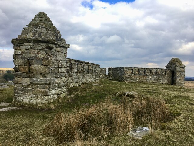
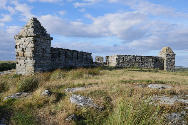
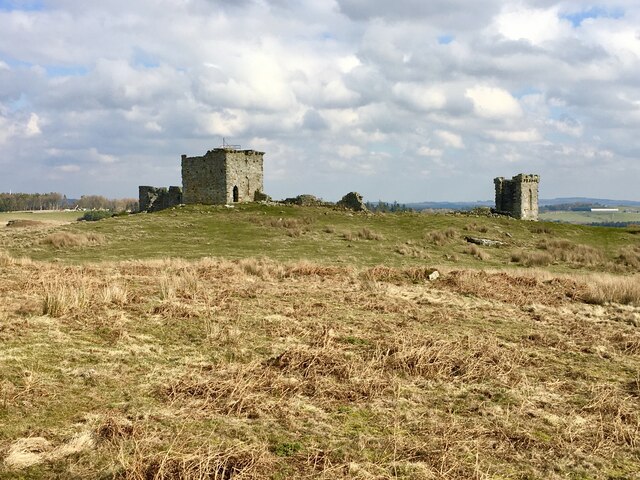
In addition to its natural beauty, Ash Plantation also holds historical significance. It is believed to have been part of an ancient forest that once covered large parts of Northumberland. Remnants of old boundary walls and stone structures can still be found within the woodland, serving as a reminder of its past.

Overall, Ash Plantation in Northumberland is a captivating and tranquil woodland, offering visitors a chance to immerse themselves in nature and experience the beauty of an ancient forest.

If you have any feedback on the listing, please let us know in the comments section below.

Ash Plantation Images

Images are sourced within 2km of 55.1897/-1.921266 or Grid Reference NZ0588. Thanks to Geograph Open Source API. All images are credited.

Codger Fort
Codger Fort
Codger Fort A folly eye-catcher?
Codger Fort
A folly eye-catcher?
Codger Fort Codger Fort was constructed by Sir Walter Blackett in the mid-eighteenth century.  See <span class="nowrap"><a title="http://www.castlesfortsbattles.co.uk/north_east/codger_fort.html" rel="nofollow ugc noopener" href="http://www.castlesfortsbattles.co.uk/north_east/codger_fort.html">Link</a><img style="margin-left:2px;" alt="External link" title="External link - shift click to open in new window" src="https://s1.geograph.org.uk/img/external.png" width="10" height="10"/></span> for further information on this prominent site above the B6342 near Rothley.

This photograph was taken during the Coronavirus (COVID-19) pandemic of 2020/21/22.
Codger Fort
Codger Fort was constructed by Sir Walter Blackett in the mid-eighteenth century. See LinkExternal link for further information on this prominent site above the B6342 near Rothley. This photograph was taken during the Coronavirus (COVID-19) pandemic of 2020/21/22.
Codger Fort atop the crags A view from the west of the impressive remains of Codger Fort.

This photograph was taken during the Coronavirus (COVID-19) pandemic of 2020/21/22.
Codger Fort atop the crags
A view from the west of the impressive remains of Codger Fort. This photograph was taken during the Coronavirus (COVID-19) pandemic of 2020/21/22.
Codger Fort This apparent ruin was a folly built by Sir William Blackett to resemble the remains of a border fort in the 18th century.
Codger Fort
This apparent ruin was a folly built by Sir William Blackett to resemble the remains of a border fort in the 18th century.
Codger Fort Built by Sir Walter Blackett above the road between Rothbury and Scots Gap, Northumberland.
Codger Fort
Built by Sir Walter Blackett above the road between Rothbury and Scots Gap, Northumberland.
B6342 heading north Towards Rothbury.
B6342 heading north
Towards Rothbury.
Codger Fort (folly) in the snow This folly near Rothley stands overlooking the now tranquil Northumbrian countryside but is evocative of the more troubled times that plagued the Scottish-English border in the past.
Codger Fort (folly) in the snow
This folly near Rothley stands overlooking the now tranquil Northumbrian countryside but is evocative of the more troubled times that plagued the Scottish-English border in the past.
Rothley Castle in Morpeth A beautiful little folly siting on crags in the spectacular Northumberland countryside.
Rothley Castle in Morpeth
A beautiful little folly siting on crags in the spectacular Northumberland countryside.
Storm Arwen chaos at Rothley Crossroads Quite a few large trees were clearly blown down across the road when Storm Arwen roared in from the north.
Storm Arwen chaos at Rothley Crossroads
Quite a few large trees were clearly blown down across the road when Storm Arwen roared in from the north.
Storm Arwen chaos at Rothley Crossroads Another view of the fallen trees and damage to the drystone wall when Storm Arwen hit.  Thin, exposed belts of east - west trees were particularly badly hit by the wind from the north.  The 17 or so large trees that were thrown directly across the road must have taken a considerable effort to clear.
Storm Arwen chaos at Rothley Crossroads
Another view of the fallen trees and damage to the drystone wall when Storm Arwen hit. Thin, exposed belts of east - west trees were particularly badly hit by the wind from the north. The 17 or so large trees that were thrown directly across the road must have taken a considerable effort to clear.
Guess which section Storm Arwen hit? Thin, exposed belts of east - west trees were particularly badly hit by the wind from the north, causing massive road obstruction in this instance.
Guess which section Storm Arwen hit?
Thin, exposed belts of east - west trees were particularly badly hit by the wind from the north, causing massive road obstruction in this instance.
Storm Arwen chaos at Rothley Crossroads The cleared trunks from some 17 trees laid across the road by the storm have been neatly deposited on the verge at the south side of the road.  See
<a href="https://www.geograph.org.uk/photo/7116673">NZ0489 : Storm Arwen chaos at Rothley Crossroads</a>
Storm Arwen chaos at Rothley Crossroads
The cleared trunks from some 17 trees laid across the road by the storm have been neatly deposited on the verge at the south side of the road. See NZ0489 : Storm Arwen chaos at Rothley Crossroads
Drystone wall surrounding wood A very well built wall, with an elegant rounded corner at this  point.  Sadly, it's suffered considerable damage on its eastern side, probably another casualty of Storm Arwen.
Drystone wall surrounding wood
A very well built wall, with an elegant rounded corner at this point. Sadly, it's suffered considerable damage on its eastern side, probably another casualty of Storm Arwen.
Drystone wall at Rothley Crags This substantial and well built drystone wall is a curious addition to the bottom of The Stell.
Drystone wall at Rothley Crags
This substantial and well built drystone wall is a curious addition to the bottom of The Stell.
Rothley Crags Seen through one of the firing holes of Rothley Castle, this is the largest of the crags.
Rothley Crags
Seen through one of the firing holes of Rothley Castle, this is the largest of the crags.
Gun loop at Rothley Castle Another, more whimsical, design of firing hole at the castle.
Gun loop at Rothley Castle
Another, more whimsical, design of firing hole at the castle.
Rothley Castle
Rothley Castle
Show me another place!

Ash Plantation is located at Grid Ref: NZ0588 (Lat: 55.1897, Lng: -1.921266)

Unitary Authority: Northumberland

Police Authority: Northumbria

What 3 Words

///ramps.fantastic.issued. Near Rothley, Northumberland

Nearby Locations

Ash Plantation

Related Wikis

Rothley Castle

Rothley Castle is an 18th-century gothic folly built to resemble a medieval castle, situated at Rothley, Northumberland. It is a Grade II* listed building...

Rothley, Northumberland

Rothley is a small settlement and civil parish in Northumberland, England about 2 miles (3 km) north east of Cambo and about 6 miles (10 km) west of Morpeth...

West Grange Hall

West Grange Hall is an English country house and estate in the village of Scots Gap, Northumberland, built between 1863 and 1896 and originally part of...

Scots Gap

Scots Gap is a small village in Northumberland, United Kingdom. == Population == Scots Gap has approximately 70 private residential dwellings, the oldest...

Scotsgap railway station

Scotsgap was a stone-built railway station in Northumberland on the Wansbeck Railway, which served the villages of Scots' Gap and Cambo. It was located...

Longwitton railway station

Longwitton station was a weather board and corrugated iron built railway station in Northumberland on the Rothbury Branch. Originally known as Rothley...

Middleton North railway station

Middleton North was a stone-built railway station on the Wansbeck Railway between Morpeth and Reedsmouth, which served the villages of Middleton and Hartburn...

Cambo, Northumberland

Cambo is a village and former civil parish, now in the parish of Wallington Demesne, in Northumberland, England. It is about 11 miles (18 km) to the west...

Nearby Amenities

Located within 500m of 55.1897,-1.921266
The Rook
Place: locality
Lat/Long: 55.1927252/-1.9201913
The data included in this document is from www.openstreetmap.org. The data is made available under ODbL.

Have you been to Ash Plantation?

Leave your review of Ash Plantation below (or comments, questions and feedback).