Horse Close Plantation

Wood, Forest in Northumberland

England

Horse Close Plantation

Storm Arwen at Castle Hill Although the storm has rendered the usual path to Castle Hill impassable there are other possible routes to this natural 'play area' which, given its exposure, has escaped with a surprisingly small amount of damage.
Storm Arwen at Castle Hill Credit: Leanmeanmo

Horse Close Plantation is a picturesque woodland located in the county of Northumberland, England. Covering an area of approximately 100 acres, it is a prime example of a well-preserved plantation forest in the region. The plantation is nestled within the beautiful landscape of the Northumberland National Park, adding to its charm and serenity.

The woodland consists primarily of oak and beech trees, with some areas featuring a mix of conifers such as pine and spruce. These tall, majestic trees create a dense canopy, providing a habitat for a wide range of wildlife. Visitors to Horse Close Plantation can expect to encounter various bird species, including woodpeckers, owls, and buzzards, as well as small mammals like red squirrels and foxes.

The plantation offers a network of well-maintained walking trails, allowing visitors to explore the woodland at their own pace. These trails wind through the forest, providing opportunities to observe the flora and fauna up close. Horse Close Plantation is particularly popular among nature enthusiasts, hikers, and birdwatchers.

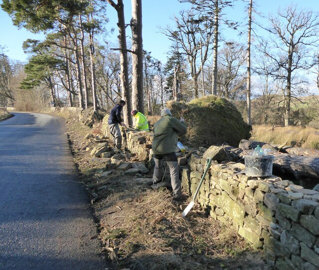
The woodland is also of historical significance, with evidence of human activity dating back centuries. Remnants of old boundary walls and stone structures can be found throughout the plantation, adding an element of intrigue and mystery to the site.

Overall, Horse Close Plantation is a haven of tranquility and natural beauty, offering visitors a chance to escape the hustle and bustle of everyday life and immerse themselves in the wonders of Northumberland's woodlands.

If you have any feedback on the listing, please let us know in the comments section below.

Horse Close Plantation Images

Images are sourced within 2km of 55.385366/-1.9230414 or Grid Reference NU0410. Thanks to Geograph Open Source API. All images are credited.

Storm Arwen at Castle Hill Although the storm has rendered the usual path to Castle Hill impassable there are other possible routes to this natural 'play area' which, given its exposure, has escaped with a surprisingly small amount of damage.
Storm Arwen at Castle Hill
Although the storm has rendered the usual path to Castle Hill impassable there are other possible routes to this natural 'play area' which, given its exposure, has escaped with a surprisingly small amount of damage.
Storm Arwen at Castle Hill Although the storm has rendered the usual path to Castle Hill impassable (left of picture) there are other possible routes to this natural 'play area' which, given its exposure, has escaped with a surprisingly small amount of damage.
Storm Arwen at Castle Hill
Although the storm has rendered the usual path to Castle Hill impassable (left of picture) there are other possible routes to this natural 'play area' which, given its exposure, has escaped with a surprisingly small amount of damage.
Storm Arwen at Callaly Woods Callaly Woods lost numerous trees to Storm Arwen on the 26th November 2021, leaving blocked tracks everywhere.  The estate has responded swiftly to clear the blocked paths and make the woods accessible again.
Storm Arwen at Callaly Woods
Callaly Woods lost numerous trees to Storm Arwen on the 26th November 2021, leaving blocked tracks everywhere. The estate has responded swiftly to clear the blocked paths and make the woods accessible again.
Callaly Castle Sometimes open to the public.
Callaly Castle
Sometimes open to the public.
Attractive avenue of trees in the late afternoon sun Castle Hill and Plantation off to the right.
Attractive avenue of trees in the late afternoon sun
Castle Hill and Plantation off to the right.
Mown field, Callaly Appears to be more of a garden extension than agricultural.
Mown field, Callaly
Appears to be more of a garden extension than agricultural.
Woodland, Callaly
Woodland, Callaly
Road, Callaly Running through a stripwood west of the castle.
Road, Callaly
Running through a stripwood west of the castle.
Young trees, Callaly A field recently planted with trees.
Young trees, Callaly
A field recently planted with trees.
Green lane, Yetlington
Callaly to Yetlington road
Stubble near High Houses Spring barley is still a crop here, good to see some Winter stubble.
Stubble near High Houses
Spring barley is still a crop here, good to see some Winter stubble.
Dry-stone wallers  Repairing the damage caused by trees felled by Storm Arwen.
Dry-stone wallers
Repairing the damage caused by trees felled by Storm Arwen.
Dry-stone wallers Reinstate the walls damaged by trees felled by Storm Arwen.
Dry-stone wallers
Reinstate the walls damaged by trees felled by Storm Arwen.
Fallen and falling trees And a bit of dry-stone wall that survived the Storm Arwen.
Fallen and falling trees
And a bit of dry-stone wall that survived the Storm Arwen.
Storm Arwen at Callaly Woods Callaly Woods lost numerous trees, hardwoods and conifers, to Storm Arwen on the 26th November 2021, leaving blocked tracks everywhere.  The estate has responded swiftly to clear the blocked paths and make the woods accessible again.  Some large trees, as in this case, one can simply walk around.
Storm Arwen at Callaly Woods
Callaly Woods lost numerous trees, hardwoods and conifers, to Storm Arwen on the 26th November 2021, leaving blocked tracks everywhere. The estate has responded swiftly to clear the blocked paths and make the woods accessible again. Some large trees, as in this case, one can simply walk around.
Country road towards Eslington Lowhill - and thence to Eslington Highhill Note the hedgerows alive with berries in this very fruitful autumn.
Country road towards Eslington Lowhill - and thence to Eslington Highhill
Note the hedgerows alive with berries in this very fruitful autumn.
Minor road junction west of Whittingham
Show me another place!

Horse Close Plantation is located at Grid Ref: NU0410 (Lat: 55.385366, Lng: -1.9230414)

Unitary Authority: Northumberland

Police Authority: Northumbria

What 3 Words

///large.producers.rather. Near Whittingham, Northumberland

Related Wikis

Callaly Castle

Callaly Castle is a Grade I listed building and a substantial country house to the north of the village of Callaly, which is some 14.5 km (9.0 mi) to the...

Callaly

Callaly is a village and civil parish in Northumberland, England. It is about 9 miles (14 km) to the west of Alnwick. The main A697 road (to Morpeth) is...

Whittingham, Northumberland

Whittingham is a village and civil parish in Northumberland, England. It is situated on the banks of the River Aln, roughly 4.5 miles (7 km) east of its...

Eslington Park

Eslington Park is a privately owned 18th-century mansion house west of Whittingham, Northumberland, near the River Aln. It is the family seat of Lord...

Yetlington

Yetlington is a village in the civil parish of Callaly, in the county of Northumberland, England. Yetlington seems to have been known in the Middle Ages...

Long Crag

Long Crag is a hill to the north of Rothbury in Northumberland, England. It lies within the Thrunton Woods, a Forestry Commission-owned area of forestry...

Thrunton Wood

Thrunton Wood is an area of woodland and open moor in Northumberland. It is popular with walkers, mountain bikers and horse riders, and home to two waymarked...

Unthank, Alnham

Unthank is a hamlet and former civil parish, now in the parish of Alnham in Northumberland, England. In 1951 the parish had a population of 11. == History... ==

Have you been to Horse Close Plantation?

Leave your review of Horse Close Plantation below (or comments, questions and feedback).