Culkein Drumbeg

Settlement in Sutherland

Scotland

Culkein Drumbeg

Gate to Lòn Ruadh, boggy flats at Oldany
Gate to Lòn Ruadh, boggy flats at Oldany Credit: Alan Reid

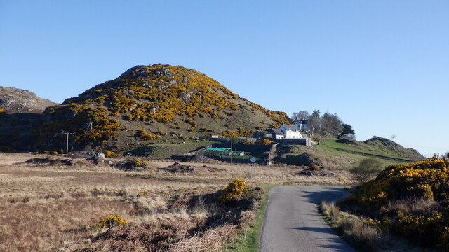
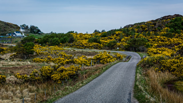
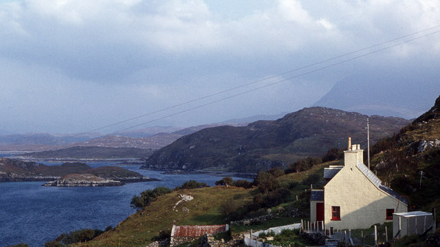
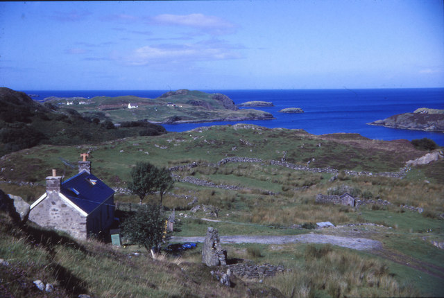
Culkein Drumbeg is a small and picturesque coastal village located in the county of Sutherland, in the Highland region of Scotland. Situated on the northwestern coast, it is nestled within the beautiful and rugged landscape of the Scottish Highlands.

The village is known for its stunning views of the North Atlantic Ocean and the nearby mountain ranges, providing a scenic backdrop for residents and visitors alike. It is a popular destination for those seeking peace and tranquility, as well as outdoor enthusiasts looking to explore the stunning natural surroundings.

Culkein Drumbeg is home to a small but tight-knit community, with a population of around 100 people. The village features a few traditional cottages and houses, adding to its charm and character. There are also a handful of local amenities, including a small shop and a community hall, which serves as a hub for social gatherings and events.

The area surrounding Culkein Drumbeg offers a wealth of outdoor activities for visitors to enjoy. Hiking and walking trails are abundant, providing opportunities to explore the rugged coastline, beautiful beaches, and rolling hills. The village is also close to Lochinver, a larger town offering additional amenities and attractions, including a renowned seafood restaurant.

Overall, Culkein Drumbeg is a hidden gem in the Scottish Highlands, offering breathtaking scenery, a close-knit community, and a chance to experience the tranquility of rural village life.

If you have any feedback on the listing, please let us know in the comments section below.

Culkein Drumbeg Images

Images are sourced within 2km of 58.251094/-5.217307 or Grid Reference NC1133. Thanks to Geograph Open Source API. All images are credited.

Gate to Lòn Ruadh, boggy flats at Oldany
Lòn Ruadh Wetland by Oldany, North Assynt. Looks like a former loch which has undergone succession.
Lòn Ruadh
Wetland by Oldany, North Assynt. Looks like a former loch which has undergone succession.
B869, Oldany
B869, Oldany
Drumbeg stores. Packed full of goodies.
Drumbeg stores.
Packed full of goodies.
The Drumbeg peat road. A short walk from the village.
The Drumbeg peat road.
A short walk from the village.
Drumbeg cattle grid.
Main road through Drumbeg
Loch Drumbeg - Quinaig behind
B869 near Oldany
B869 near Oldany
Road on Outskirts of Drumbeg
Drumbeg Public Conveniences
Drumbeg - Various Buildings Some sign of derelict farm buildings.
Drumbeg - Various Buildings
Some sign of derelict farm buildings.
View of Eilean an Achaidh Viewing station for the Loch Dhrombaig and Islands.
View of Eilean an Achaidh
Viewing station for the Loch Dhrombaig and Islands.
Cottage overlooking Loch Dhrombaig Looking east towards Sail Ghorm (Quinag), which is in the haze above the cottage.
Cottage overlooking Loch Dhrombaig
Looking east towards Sail Ghorm (Quinag), which is in the haze above the cottage.
Loch Dhrombaig From Drumbeg towards Loch Dhrombaig and Culkein Drumbeg
Loch Dhrombaig
From Drumbeg towards Loch Dhrombaig and Culkein Drumbeg
Drumbeg Drumbeg village towards Sail Gorm and Quinag
Drumbeg
Drumbeg village towards Sail Gorm and Quinag
Loch Drumbeg
Loch Drumbeg
The Steading for Crafts
Show me another place!

Culkein Drumbeg is located at Grid Ref: NC1133 (Lat: 58.251094, Lng: -5.217307)

Unitary Authority: Highland

Police Authority: Highlands and Islands

What 3 Words

///surprises.prelude.caravan. Near Clachtoll, Highland

Related Wikis

Culkein Drumbeg

Culkein Drumbeg (Scottish Gaelic: Cùl-cinn an Droma Bhig) is a remote village on the north west coast of Scotland. It is located 0.93 miles (1.50 km) north...
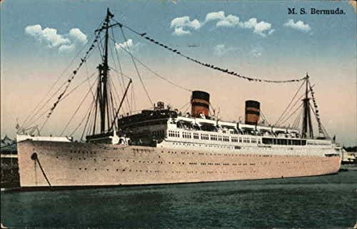
MV Bermuda

MV Bermuda was a passenger motor ship that Furness, Withy's Furness Bermuda Line operated between New York and Bermuda from 1928 until 1931. She was damaged...

Drumbeg, Sutherland

Drumbeg (Scottish Gaelic: An Druim Beag) is a remote crofting village on the north west coast of Scotland in Assynt, Sutherland, Scottish Highlands and...

Oldany Island

Oldany Island (formerly Oldney Island) is an uninhabited island in Assynt, Sutherland, north-west Scotland. The name is Norse in origin and possibly means...

Nearby Amenities

Located within 500m of 58.251094,-5.217307
Source: PGS
Lat/Long: 58.2488145/-5.2110149
Source: PGS
Lat/Long: 58.2492052/-5.2116221
Source: PGS
Lat/Long: 58.2495917/-5.2124252
Source: PGS
Lat/Long: 58.2498198/-5.2130989
Source: PGS
Lat/Long: 58.249953/-5.2134251
Source: PGS
Lat/Long: 58.2502844/-5.2139728
Source: PGS
Lat/Long: 58.2512631/-5.2132062
Source: PGS
Lat/Long: 58.251623/-5.2129595
Source: PGS
Lat/Long: 58.251851/-5.2126328
Source: PGS
Lat/Long: 58.2524395/-5.2123147
Source: PGS
Lat/Long: 58.2524943/-5.212113
Source: PGS
Lat/Long: 58.2527797/-5.2121162
Source: PGS
Lat/Long: 58.2528587/-5.2122905
Created By: almien_coastlines
Source: PGS
Lat/Long: 58.253152/-5.21204
Source: PGS
Lat/Long: 58.2535071/-5.211849
Source: PGS
Lat/Long: 58.2537408/-5.2124547
Created By: almien_coastlines
Source: PGS
Lat/Long: 58.25377/-5.213292
Source: PGS
Lat/Long: 58.2537532/-5.2143499
Source: PGS
Lat/Long: 58.2538968/-5.2148354
Source: PGS
Lat/Long: 58.2540535/-5.2148225
Source: PGS
Lat/Long: 58.2545551/-5.2148574
Source: PGS
Lat/Long: 58.2549242/-5.2152833
Source: PGS
Lat/Long: 58.2549647/-5.2155528
Source: PGS
Lat/Long: 58.2549379/-5.2160458
Source: PGS
Lat/Long: 58.2552012/-5.2155082
Source: PGS
Lat/Long: 58.2555433/-5.2160399
Created By: almien_coastlines
Source: PGS
Lat/Long: 58.255332/-5.219219
Source: PGS
Lat/Long: 58.2553158/-5.2195246
Created By: almien_coastlines
Source: PGS
Lat/Long: 58.254931/-5.220166
Source: PGS
Lat/Long: 58.2546319/-5.2204821
Source: PGS
Lat/Long: 58.2544394/-5.2209048
Source: PGS
Lat/Long: 58.2544866/-5.2210813
Source: PGS
Lat/Long: 58.2537183/-5.2214874
Source: PGS
Lat/Long: 58.253604/-5.2214847
Source: PGS
Lat/Long: 58.2532195/-5.222519
Source: PGS
Lat/Long: 58.2528148/-5.2232089
Source: PGS
Lat/Long: 58.2528277/-5.2240125
Source: PGS
Lat/Long: 58.2527541/-5.2242034
Source: PGS
Lat/Long: 58.2525105/-5.2241079
Source: PGS
Lat/Long: 58.2522787/-5.2237383
Source: PGS
Lat/Long: 58.2520857/-5.2234567
Source: PGS
Lat/Long: 58.2517709/-5.2242962
Source: PGS
Lat/Long: 58.2516499/-5.2248525
Source: PGS
Lat/Long: 58.2515722/-5.2251508
Source: PGS
Lat/Long: 58.2513038/-5.2252253
Source: PGS
Lat/Long: 58.250761/-5.2257377
Bus Stop
Culkein Drumbeg
Naptan AtcoCode: 6700712588
Naptan Bearing: SE
Naptan CommonName: Culkein Drumbeg
Naptan Indicator: at Jetty
Naptan Landmark: Jetty
Naptan NaptanCode: 45327943
Naptan Street: Village Road
Naptan Verified: no
Source: naptan_import
Lat/Long: 58.2525006/-5.2239774
Barrier: cattle_grid
Lat/Long: 58.252055/-5.2219968
Power: pole
Lat/Long: 58.2468867/-5.2174802
Power: pole
Lat/Long: 58.2472468/-5.2173965
Power: pole
Lat/Long: 58.247966/-5.2172048
Power: pole
Lat/Long: 58.2486094/-5.2170451
Power: pole
Lat/Long: 58.2490028/-5.2164884
Power: pole
Lat/Long: 58.249308/-5.2160582
Power: pole
Lat/Long: 58.2521456/-5.221947
Power: pole
Lat/Long: 58.2520554/-5.2210593
Power: pole
Lat/Long: 58.251869/-5.2193034
Power: pole
Lat/Long: 58.2513927/-5.2169887
Power: pole
Lat/Long: 58.2504564/-5.2182249
Power: pole
Lat/Long: 58.2507647/-5.2178122
Culkein Drumbeg
Name Gd: Cùl-cinn Dhrombaig
Place: hamlet
Wikidata: Q3775717
Wikipedia: en:Culkein Drumbeg
Lat/Long: 58.2516116/-5.2176833
Tor Druim
Description: Tor Druim B&B
Tourism: hotel
Lat/Long: 58.2516457/-5.2151316
The data included in this document is from www.openstreetmap.org. The data is made available under ODbL.

Have you been to Culkein Drumbeg?

Leave your review of Culkein Drumbeg below (or comments, questions and feedback).