Balaam's Wood

Wood, Forest in Worcestershire

England

Balaam's Wood

The River Rea emerging from under the Bristol Road South bridge
The River Rea emerging from under the Bristol Road South bridge Credit: Roy Hughes

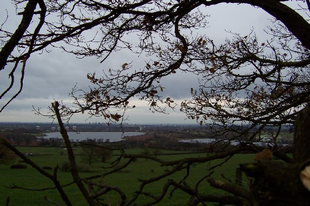
Balaam's Wood is a picturesque woodland located in Worcestershire, England. Situated in the heart of the county, it forms part of the larger Balaam's Wood and Dodderhill Commons Local Nature Reserve, which covers an area of approximately 51 hectares.

This ancient woodland is renowned for its natural beauty and diverse ecosystem. The wood is predominantly composed of native broadleaf trees, such as oak, ash, and beech, creating a rich and vibrant canopy that changes with the seasons. Bluebells, wood anemones, and primroses carpet the forest floor in spring, providing a stunning display of colors.

The woodland supports a wide variety of wildlife, making it a popular spot for nature enthusiasts. Birdsong can be heard throughout the year, with species such as great spotted woodpeckers, nuthatches, and chiffchaffs commonly seen. Mammals such as foxes, badgers, and deer also call Balaam's Wood their home.

Several walking trails and footpaths wind their way through the wood, allowing visitors to explore its natural wonders. These paths provide opportunities for peaceful walks, birdwatching, and photography. The wood also features a small pond and a stream, adding to its charm and biodiversity.

Balaam's Wood holds significant historical value, with evidence of human activity dating back centuries. It is believed that the wood has been continuously wooded since at least the 1600s. Today, it is managed and protected by the Worcestershire County Council, ensuring its preservation for future generations to enjoy.

If you have any feedback on the listing, please let us know in the comments section below.

Balaam's Wood Images

Images are sourced within 2km of 52.403439/-2.0085839 or Grid Reference SO9978. Thanks to Geograph Open Source API. All images are credited.

The River Rea emerging from under the Bristol Road South bridge
River Rea passing under Bristol Road South, Longbridge
Pedestrian path under the Bristol Road South, Longbridge
River Rea looking towards Rubery
Crossing Longbridge Lane to Longbridge railway station
Cycle Route 5 sign at Tessall Lane junction with Rea Valley path, Longbridge
The Greenlands Inn, Longbridge
Park Point at Dusk Despite it being a weekday after 7pm, the redeveloped mixed-use area here was still bustling with people and had a pleasant vibe. There are some interesting buildings set in a high-quality urban design. In this view the Cambridge 'Hungry Horse' pub takes centre place.
Park Point at Dusk
Despite it being a weekday after 7pm, the redeveloped mixed-use area here was still bustling with people and had a pleasant vibe. There are some interesting buildings set in a high-quality urban design. In this view the Cambridge 'Hungry Horse' pub takes centre place.
Art Deco building, 1730 Bristol Road South One of the commercial premises on the south side of the A38, with a distinctly 1920s Art Deco look to it. There is an OS benchmark cut into the brickwork low on the 'tower'
Art Deco building, 1730 Bristol Road South
One of the commercial premises on the south side of the A38, with a distinctly 1920s Art Deco look to it. There is an OS benchmark cut into the brickwork low on the 'tower'
OS benchmark - Longbridge, 1730 Bristol Rd South An OS cutmark on the 'tower' part of <a href="https://www.geograph.org.uk/photo/7423346">SP0077 : Art Deco building, 1730 Bristol Road South</a>, which was last levelled by the OS in 1956 at 180.146m above Ordnance Datum Newlyn.
OS benchmark - Longbridge, 1730 Bristol Rd South
An OS cutmark on the 'tower' part of SP0077 : Art Deco building, 1730 Bristol Road South, which was last levelled by the OS in 1956 at 180.146m above Ordnance Datum Newlyn.
Longbridge Methodist Church Located just off the main A38 Bristol Road South.
Longbridge Methodist Church
Located just off the main A38 Bristol Road South.
Houses west of the former motor works A view down the intriguingly named Tinmeadow Crescent.
Houses west of the former motor works
A view down the intriguingly named Tinmeadow Crescent.
Lowhill Lane junction on the A4120 Lickey Road
Traffic emerging from Edgewood Road Cars coming out onto the Lickey Road from Edgewood Road in Rednal.
Traffic emerging from Edgewood Road
Cars coming out onto the Lickey Road from Edgewood Road in Rednal.
A Prospect of Birmingham The view from Frankley Beeches. Below, the reservoirs where the city's water is kept when it arrives from Wales.
A Prospect of Birmingham
The view from Frankley Beeches. Below, the reservoirs where the city's water is kept when it arrives from Wales.
Water Tower, Hollymoor Hospital, Northfield, Birmingham All that remains of this former mental hospital. Water towers were standard features of late Victorian mental hospitals.
Water Tower, Hollymoor Hospital, Northfield, Birmingham
All that remains of this former mental hospital. Water towers were standard features of late Victorian mental hospitals.
Longbridge Station This modern station building by the bridge taking Longbridge Lane over the Birmingham - Bristol line was built in the 1970s when the station was opened as part of the Cross-City line suburban service from Redditch to Lichfield.
Longbridge Station
This modern station building by the bridge taking Longbridge Lane over the Birmingham - Bristol line was built in the 1970s when the station was opened as part of the Cross-City line suburban service from Redditch to Lichfield.
Longbridge roundabout Signs of the regeneration efforts at the former Longbridge Car works - on the very long bridge linking different parts of the site across the Bristol Road.
Longbridge roundabout
Signs of the regeneration efforts at the former Longbridge Car works - on the very long bridge linking different parts of the site across the Bristol Road.
Show me another place!

Balaam's Wood is located at Grid Ref: SO9978 (Lat: 52.403439, Lng: -2.0085839)

Unitary Authority: Birmingham

Police Authority: West Midlands

What 3 Words

///valid.reward.fired. Near Bartley Green, West Midlands

Nearby Locations

Holly Hill Balaam's Wood

Related Wikis

Rubery railway station

Rubery railway station was a railway station in Rubery, Birmingham, England, on the Great Western Railway and Midland Railway's joint Halesowen Railway...

King Edward VI Balaam Wood Academy

King Edward VI Balaam Wood Academy is a coeducational secondary school located in the New Frankley area of Birmingham, West Midlands, England.The school...

Rubery Hill Hospital

Rubery Hill Hospital was a mental health facility in Birmingham, England. The Chapel, which still survives, is a Grade II listed building. == History... ==

Hollymoor Hospital

Hollymoor Hospital was a psychiatric hospital located at Tessall Lane, Northfield in Birmingham, England, and is famous primarily for the work on group...

Colmers School

Colmers School is a coeducational secondary school and sixth form located in the Rednal area of Birmingham, in the West Midlands of England.Previously...

New Frankley

New Frankley in Birmingham is a civil parish in Birmingham, England. As such, it has its own parish council. == History == It was established in 2000 in...

St Chad's Church, Rubery

St Chad’s Church, Rubery is a Church of England parish church in Rubery, Worcestershire. == History == The church evolved in 1895 as a mission church from...

Longbridge railway station (1915–1964)

Longbridge railway station was a railway station in Longbridge, Birmingham, England, on the Great Western Railway and Midland Railway's joint Halesowen...

Nearby Amenities

Located within 500m of 52.403439,-2.0085839
Crossing
Bicycle: yes
Crossing: traffic_signals
Crossing Ref: toucan
Source Type: BCC_CycleData
Lat/Long: 52.4022302/-2.0065784
Segregated: no
Lat/Long: 52.4006988/-2.0049999
Rubery
Historic Railway: station
Railway: site
Wikidata: Q7376043
Wikipedia: en:Rubery railway station
Lat/Long: 52.4025463/-2.0144653
Barrier: bollard
Lat/Long: 52.4039591/-2.0031096
Bus Stop
New St / Frogmill Rd
Bus: yes
Naptan AtcoCode: 43000393101
Naptan Bearing: W
Naptan BusStopType: MKD
Naptan CommonName: Frogmill Rd
Naptan Indicator: after
Naptan NaptanCode: nwmawtat
Naptan PlusbusZoneRef: BHAMNWS
Naptan Status: ACT
Naptan StopType: BCT
Naptan Street: NEW ST
Naptan Towards: Northfield (via Holly Hill Rd)
Public Transport: platform
Route Ref: 49;X61
Source: WMCA
Lat/Long: 52.4030486/-2.0055837
Bus Stop
New St / Cotswold Close
Bus: yes
Naptan AtcoCode: 43000393202
Naptan Bearing: E
Naptan BusStopType: MKD
Naptan CommonName: Cotswold Close
Naptan Indicator: adj
Naptan NaptanCode: nwmawtdg
Naptan PlusbusZoneRef: BHAMNWS
Naptan Status: ACT
Naptan StopType: BCT
Naptan Street: NEW ST
Naptan Towards: Northfield (via Tessall Lane)
Public Transport: platform
Route Ref: 49;X61
Source: WMCA
Lat/Long: 52.4040139/-2.0079817
Bus Stop
New St / Cotswold Close
Bus: yes
Naptan AtcoCode: 43000393201
Naptan Bearing: W
Naptan BusStopType: MKD
Naptan CommonName: Cotswold Close
Naptan Indicator: opp
Naptan NaptanCode: nwmawtda
Naptan PlusbusZoneRef: BHAMNWS
Naptan Status: ACT
Naptan StopType: BCT
Naptan Street: NEW ST
Naptan Towards: Northfield (via Holly Hill Rd)
Naptan Refresh: query
Public Transport: platform
Route Ref: 49;X61
Source: WMCA
Lat/Long: 52.4039252/-2.0081123
Turning Circle
Lat/Long: 52.4033585/-2.0104293
Bus Stop
New St / Ringwood Drive
Bus: yes
Naptan AtcoCode: 43000393301
Naptan Bearing: W
Naptan BusStopType: MKD
Naptan CommonName: Ringwood Drive
Naptan Indicator: adj
Naptan NaptanCode: nwmawtdj
Naptan PlusbusZoneRef: BHAMNWS
Naptan Status: ACT
Naptan StopType: BCT
Naptan Street: NEW ST
Naptan Towards: Northfield (via Holly Hill Rd)
Naptan Verified: no
Public Transport: platform
Route Ref: 49;X61
Source: WMCA
Lat/Long: 52.4042497/-2.0113019
Bus Stop
New St / Ringwood Drive
NaPTANAreaCode: 43000393302
Bus: yes
Naptan AtcoCode: 43000393302
Naptan Bearing: E
Naptan BusStopType: MKD
Naptan CommonName: Ringwood Drive
Naptan Indicator: opp
Naptan NaptanCode: nwmawtdm
Naptan PlusbusZoneRef: BHAMNWS
Naptan Status: ACT
Naptan StopType: BCT
Naptan Street: NEW ST
Naptan Towards: Northfield (via Tessall Lane)
Naptan Verified: no
Public Transport: platform
Route Ref: 49;X61
Shelter: yes
Shelter Ref: 610204
Source: WMCA
Lat/Long: 52.4043732/-2.0118183
Bus Stop
Arden Rd / Holly Hill Shopping Centre
NaPTANAreaCode: 43003921003
Bus: yes
Naptan AtcoCode: 43003921003
Naptan Bearing: S
Naptan BusStopType: MKD
Naptan CommonName: Holly Hill Shopping Centre
Naptan Indicator: opp
Naptan NaptanCode: nwmtmwmd
Naptan PlusbusZoneRef: BHAMNWS
Naptan Status: ACT
Naptan StopType: BCT
Naptan Street: ARDEN RD
Naptan Towards: Rubery
Public Transport: platform
Route Ref: 19;63;202;X61
Shelter: yes
Shelter Ref: 611806
Source: WMCA
Lat/Long: 52.4025455/-2.0155715
Bus Stop
Arden Rd / Holly Hill Shopping Centre
NaPTANAreaCode: 43003921002
Bus: yes
Naptan AtcoCode: 43003921002
Naptan Bearing: N
Naptan BusStopType: MKD
Naptan CommonName: Holly Hill Shopping Centre
Naptan Indicator: adj
Naptan NaptanCode: nwmawptp
Naptan PlusbusZoneRef: BHAMNWS
Naptan Status: ACT
Naptan StopType: BCT
Naptan Street: ARDEN RD
Naptan Towards: Bartley Green
Public Transport: platform
Route Ref: 19;63;202;X61
Shelter: yes
Shelter Ref: 611805
Source: WMCA
Lat/Long: 52.402658/-2.0157636
Bus Stop
New St / Holly Hill Rd
Bus: yes
Naptan AtcoCode: 43000393801
Naptan Bearing: E
Naptan BusStopType: MKD
Naptan CommonName: Holly Hill Rd
Naptan Indicator: after
Naptan NaptanCode: nwmawtgt
Naptan PlusbusZoneRef: BHAMNWS
Naptan Status: ACT
Naptan StopType: BCT
Naptan Street: NEW ST
Naptan Towards: Northfield (via Tessall Lane)
Public Transport: platform
Route Ref: 29;49;202;X61
Source: WMCA
Lat/Long: 52.4044768/-2.0141995
Bus Stop
New St / Holly Hill Rd
NaPTANAreaCode: 43000393802
Bus: yes
Naptan AtcoCode: 43000393802
Naptan Bearing: W
Naptan BusStopType: MKD
Naptan CommonName: Holly Hill Rd
Naptan Indicator: before
Naptan NaptanCode: nwmawtgw
Naptan PlusbusZoneRef: BHAMNWS
Naptan Status: ACT
Naptan StopType: BCT
Naptan Street: NEW ST
Naptan Towards: Northfield (via Holly Hill Rd)
Public Transport: platform
Route Ref: 29;49;202;X61
Shelter: yes
Shelter Ref: 610203
Source: WMCA
Lat/Long: 52.4044224/-2.0149096
Post Box
Post Box Type: pillar
Ref: B45 1306
Lat/Long: 52.4065366/-2.0112594
Frankley Convenience News Store
Alt Name: Frankley's Local
Brand: Premier
Shop: convenience
Lat/Long: 52.4065659/-2.0114015
Turning Circle
Lat/Long: 52.4065057/-2.0091198
Turning Circle
Lat/Long: 52.4070711/-2.0095828
Turning Circle
Lat/Long: 52.4053791/-2.0149306
Crossing
Crossing: traffic_signals
Crossing Ref: pelican
Kerb: flush
Tactile Paving: yes
Lat/Long: 52.4002972/-2.005943
Traffic Signals
Source: bing
Lat/Long: 52.4017297/-2.0074677
Mini Roundabout
Direction: clockwise
Lat/Long: 52.4013262/-2.0133319
Cycleway: asl
Source: bing
Lat/Long: 52.4020218/-2.0077876
Bus Stop
Rubery Lane / Ormond Rd
Bus: yes
Naptan AtcoCode: 43000361602
Naptan Bearing: E
Naptan BusStopType: MKD
Naptan CommonName: Ormond Rd
Naptan Indicator: after
Naptan Landmark: Factories
Naptan NaptanCode: nwmawajt
Naptan PlusbusZoneRef: BHAMNWS
Naptan Status: ACT
Naptan StopType: BCT
Naptan Street: RUBERY LANE
Naptan Towards: Northfield
Public Transport: platform
Route Ref: 49
Source: WMCA
Lat/Long: 52.4019369/-2.0106564
Bus Stop
Rubery Lane / Frogmill Rd
Bus: yes
Naptan CommonName: Frogmill Rd
Naptan PlusbusZoneRef: BHAMNWS
Naptan Status: ACT
Naptan StopType: BCT
Naptan Street: RUBERY LANE
Naptan Towards: Northfield
Naptan Verified: no
Public Transport: platform
Source: WMCA
Lat/Long: 52.4023807/-2.0047634
Bus Stop
Rubery Lane / Ormond Rd
NaPTANAreaCode: 43000361601
Bus: yes
Naptan AtcoCode: 43000361601
Naptan Bearing: W
Naptan BusStopType: MKD
Naptan CommonName: Ormond Rd
Naptan Indicator: before
Naptan Landmark: Factories
Naptan NaptanCode: nwmawajp
Naptan PlusbusZoneRef: BHAMNWS
Naptan Status: ACT
Naptan StopType: BCT
Naptan Street: RUBERY LANE
Naptan Towards: Rubery
Public Transport: platform
Route Ref: 49
Shelter: yes
Shelter Ref: 611809
Source: WMCA
Lat/Long: 52.4018056/-2.0109122
Bus Stop
Hollymoor Way / Balaams Wood Drive
Bus: yes
Naptan AtcoCode: 43000361701
Naptan Bearing: SE
Naptan BusStopType: MKD
Naptan CommonName: Balaams Wood Drive
Naptan Indicator: opp
Naptan NaptanCode: nwmwapap
Naptan Status: ACT
Naptan StopType: BCT
Naptan Street: HOLLYMOOR WAY
Naptan Towards: Rubery
Naptan Verified: no
Public Transport: platform
Route Ref: 42
Source: WMCA
Lat/Long: 52.4023779/-2.0022783
Bus Stop
New St / Frogmill Rd
NaPTANAreaCode: 43000393102
Bus: yes
Naptan AtcoCode: 43000393102
Naptan Bearing: E
Naptan BusStopType: MKD
Naptan CommonName: Frogmill Rd
Naptan Indicator: before
Naptan NaptanCode: nwmawtaw
Naptan PlusbusZoneRef: BHAMNWS
Naptan Status: ACT
Naptan StopType: BCT
Naptan Street: NEW ST
Naptan Towards: Northfield (via Tessall Lane)
Public Transport: platform
Route Ref: 49;X61
Shelter: yes
Shelter Ref: 610328
Source: WMCA
Lat/Long: 52.4030877/-2.0048698
Bus Stop
Holly Hill Rd / Brightstone Rd
Bus: yes
Naptan AtcoCode: 43000393701
Naptan Bearing: SW
Naptan BusStopType: MKD
Naptan CommonName: Brightstone Rd
Naptan Indicator: adj
Naptan NaptanCode: nwmawtgm
Naptan PlusbusZoneRef: BHAMNWS
Naptan Status: ACT
Naptan StopType: BCT
Naptan Street: HOLLY HILL RD
Naptan Towards: Rubery
Naptan Verified: no
Public Transport: platform
Route Ref: 29;49;202
Source: WMCA
Lat/Long: 52.406854/-2.0105615
Bus Stop
Holly Hill Rd / Brightstone Rd
NaPTANAreaCode: 43000393702
Bus: yes
Naptan AtcoCode: 43000393702
Naptan Bearing: NE
Naptan BusStopType: MKD
Naptan CommonName: Brightstone Rd
Naptan Indicator: opp
Naptan NaptanCode: nwmawtgp
Naptan PlusbusZoneRef: BHAMNWS
Naptan Status: ACT
Naptan StopType: BCT
Naptan Street: HOLLY HILL RD
Naptan Towards: Northfield
Naptan Verified: no
Public Transport: platform
Route Ref: 29;49;202
Shelter: yes
Shelter Ref: 610201
Source: WMCA
Lat/Long: 52.4063305/-2.0114251
Bus Stop
Holly Hill Rd / Savernake Close
Bus: yes
Naptan AtcoCode: 43000395301
Naptan Bearing: NE
Naptan BusStopType: MKD
Naptan CommonName: Savernake Close
Naptan Indicator: before
Naptan NaptanCode: nwmtwpjg
Naptan PlusbusZoneRef: BHAMNWS
Naptan Status: ACT
Naptan StopType: BCT
Naptan Street: HOLLY HILL RD
Naptan Towards: Northfield
Public Transport: platform
Route Ref: 29;49;202
Source: WMCA
Lat/Long: 52.4056123/-2.0133432
Bus Stop
Holly Hill Rd / Savernake Close
Bus: yes
Naptan AtcoCode: 43000395302
Naptan Bearing: SW
Naptan BusStopType: MKD
Naptan CommonName: Savernake Close
Naptan Indicator: after
Naptan NaptanCode: nwmtwpjm
Naptan PlusbusZoneRef: BHAMNWS
Naptan Status: ACT
Naptan StopType: BCT
Naptan Street: HOLLY HILL RD
Naptan Towards: Rubery
Naptan Verified: no
Public Transport: platform
Route Ref: 29;49;202
Source: WMCA
Lat/Long: 52.4055066/-2.0133593
Barrier: bollard
Lat/Long: 52.4040412/-2.0032667
Traffic Signals
Source: bing
Lat/Long: 52.4019446/-2.0073135
Traffic Signals
Source: bing
Lat/Long: 52.4020065/-2.0077492
Barrier: bollard
Lat/Long: 52.4021943/-2.0053392
Barrier: bollard
Lat/Long: 52.4021893/-2.0053732
Barrier: bollard
Lat/Long: 52.4021856/-2.0053928
Barrier: bollard
Lat/Long: 52.4021561/-2.0056003
Barrier: bollard
Lat/Long: 52.4021543/-2.0056176
Barrier: bollard
Lat/Long: 52.402152/-2.0056402
Barrier: bollard
Lat/Long: 52.4021501/-2.0056516
Barrier: bollard
Lat/Long: 52.4021925/-2.0053536
Barrier: bollard
Lat/Long: 52.4017226/-2.0018171
Bus Stop
Arden Rd / Arden Road Terminus
Bus: yes
Naptan AtcoCode: 43003921101
Naptan Bearing: E
Naptan BusStopType: MKD
Naptan CommonName: Arden Road Terminus
Naptan NaptanCode: nwmwgmgm
Naptan Status: ACT
Naptan StopType: BCT
Naptan Street: ARDEN RD
Naptan Towards: Birmingham
Public Transport: platform
Source: WMCA
Lat/Long: 52.403386/-2.0147132
Bus Stop
Ormond Rd / Holly Hill Shopping Centre
Bus: yes
Naptan AtcoCode: 43000392102
Naptan Bearing: E
Naptan BusStopType: MKD
Naptan CommonName: Holly Hill Shopping Centre
Naptan NaptanCode: nwmtpmtg
Naptan Status: ACT
Naptan StopType: BCT
Naptan Street: ORMOND RD
Public Transport: platform
Source: WMCA
Lat/Long: 52.4022532/-2.0153154
Post Box
Post Box Type: pillar
Ref: B45 100
Royal Cypher: EIIR
Royal Cypher Wikidata: Q33102113
Lat/Long: 52.401059/-2.0071131
Power: substation
Source: survey
Lat/Long: 52.3999936/-2.0056111
Power: substation
Lat/Long: 52.4034564/-2.0041332
Communication Mobile Phone: yes
Man Made: mast
Operator: Vodafone
Tower Construction: tube
Tower Type: communication
Lat/Long: 52.402684/-2.0154575
Man Made: street_cabinet
Operator: Vodafone
Street Cabinet: telecom
Lat/Long: 52.4026414/-2.0154843
Man Made: street_cabinet
Operator: Vodafone
Street Cabinet: telecom
Lat/Long: 52.4026537/-2.0154803
Brand: National Grid
Brand Wikidata: Q1465461
Operator: National Grid Electricity Distribution Plc
Operator Old: Western Power Distribution
Operator Wikidata: Q7988183
Owner: National Grid Electricity Distribution (West Midlands) Plc
Owner Wikidata: Q114397791
Power: substation
Ref: 01109
Lat/Long: 52.4032813/-2.0140654
Man Made: street_cabinet
Street Cabinet: telecom
Lat/Long: 52.4034326/-2.0147534
Street Lamp
Communication Mobile Phone: yes
Man Made: mast
Tower Type: communication
Lat/Long: 52.4034187/-2.0147091
Man Made: street_cabinet
Source: survey
Street Cabinet: telecom
Lat/Long: 52.4033926/-2.0026298
Crossing
Crossing: unmarked
Kerb: flush
Tactile Paving: yes
Lat/Long: 52.399689/-2.0048766
Atm
Lat/Long: 52.3993991/-2.0056907
Entrance: main
Lat/Long: 52.3996002/-2.0054307
Generator Method: photovoltaic
Generator Output Electricity: yes
Generator Source: solar
Generator Type: solar_photovoltaic_panel
Location: roof
Power: generator
Lat/Long: 52.4014599/-2.0030496
Generator Method: photovoltaic
Generator Output Electricity: yes
Generator Source: solar
Generator Type: solar_photovoltaic_panel
Location: roof
Power: generator
Lat/Long: 52.4015254/-2.0046911
Generator Method: photovoltaic
Generator Output Electricity: yes
Generator Source: solar
Generator Type: solar_photovoltaic_panel
Location: roof
Power: generator
Lat/Long: 52.4028836/-2.0057532
Generator Method: photovoltaic
Generator Output Electricity: yes
Generator Source: solar
Generator Type: solar_photovoltaic_panel
Location: roof
Power: generator
Lat/Long: 52.40677/-2.0086151
Generator Method: photovoltaic
Generator Output Electricity: yes
Generator Source: solar
Generator Type: solar_photovoltaic_panel
Location: roof
Power: generator
Lat/Long: 52.4052204/-2.0085213
Generator Method: photovoltaic
Generator Output Electricity: yes
Generator Source: solar
Generator Type: solar_photovoltaic_panel
Location: roof
Power: generator
Lat/Long: 52.4055378/-2.0087841
Generator Method: photovoltaic
Generator Output Electricity: yes
Generator Source: solar
Generator Type: solar_photovoltaic_panel
Location: roof
Power: generator
Lat/Long: 52.4046182/-2.009849
Generator Method: photovoltaic
Generator Output Electricity: yes
Generator Source: solar
Generator Type: solar_photovoltaic_panel
Location: roof
Power: generator
Lat/Long: 52.4035595/-2.0112008
Generator Method: photovoltaic
Generator Output Electricity: yes
Generator Source: solar
Generator Type: solar_photovoltaic_panel
Location: roof
Power: generator
Lat/Long: 52.4035562/-2.0111203
Generator Method: photovoltaic
Generator Output Electricity: yes
Generator Source: solar
Generator Type: solar_photovoltaic_panel
Location: roof
Power: generator
Lat/Long: 52.4075521/-2.0112826
Generator Method: photovoltaic
Generator Output Electricity: yes
Generator Source: solar
Generator Type: solar_photovoltaic_panel
Location: roof
Power: generator
Lat/Long: 52.4075374/-2.0112129
Generator Method: photovoltaic
Generator Output Electricity: yes
Generator Source: solar
Generator Type: solar_photovoltaic_panel
Location: roof
Power: generator
Lat/Long: 52.4058095/-2.0027921
Generator Method: photovoltaic
Generator Output Electricity: yes
Generator Source: solar
Generator Type: solar_photovoltaic_panel
Location: roof
Power: generator
Lat/Long: 52.4060025/-2.0025426
Generator Method: photovoltaic
Generator Output Electricity: yes
Generator Source: solar
Generator Type: solar_photovoltaic_panel
Location: roof
Power: generator
Lat/Long: 52.4018968/-2.0027867
Generator Method: photovoltaic
Generator Output Electricity: yes
Generator Source: solar
Generator Type: solar_photovoltaic_panel
Location: roof
Power: generator
Lat/Long: 52.4048367/-2.0051229
Give Way
Direction: forward
Lat/Long: 52.4046738/-2.0153783
Generator Method: photovoltaic
Generator Output Electricity: yes
Generator Source: solar
Generator Type: solar_photovoltaic_panel
Location: roof
Power: generator
Lat/Long: 52.4062071/-2.0128021
Generator Method: photovoltaic
Generator Output Electricity: yes
Generator Source: solar
Generator Type: solar_photovoltaic_panel
Location: roof
Power: generator
Lat/Long: 52.4069811/-2.012051
Generator Method: photovoltaic
Generator Output Electricity: yes
Generator Source: solar
Generator Type: solar_photovoltaic_panel
Location: roof
Power: generator
Lat/Long: 52.4015229/-2.0085347
Cycleway: asl
Lat/Long: 52.4017013/-2.007443
Cycleway: asl
Lat/Long: 52.4019615/-2.0072767
Generator Method: photovoltaic
Generator Output Electricity: yes
Generator Source: solar
Generator Type: solar_photovoltaic_panel
Location: roof
Power: generator
Lat/Long: 52.401833/-2.0092066
Generator Method: photovoltaic
Generator Output Electricity: yes
Generator Source: solar
Generator Type: solar_photovoltaic_panel
Location: roof
Power: generator
Lat/Long: 52.4018085/-2.009405
Bus Stop
Rubery Lane / Frogmill Rd
Bus: yes
Naptan AtcoCode: 43000361501
Naptan Bearing: NE
Naptan BusStopType: MKD
Naptan CommonName: Frogmill Rd
Naptan Indicator: adj
Naptan NaptanCode: nwmawajg
Naptan PlusbusZoneRef: BHAMNWS
Naptan Status: ACT
Naptan StopType: BCT
Naptan Street: RUBERY LANE
Naptan Towards: Northfield
Naptan Verified: no
Public Transport: platform
Route Ref: 42;49
Source: WMCA
Lat/Long: 52.4025985/-2.004378
The data included in this document is from www.openstreetmap.org. The data is made available under ODbL.

Have you been to Balaam's Wood?

Leave your review of Balaam's Wood below (or comments, questions and feedback).