Deanend Bushes

Wood, Forest in Dorset

England

Deanend Bushes

Longcroft Road Footpath BSJO 19 follows this track through Long Croft in Chase Woods.
Longcroft Road Credit: Derek Harper

Deanend Bushes is a picturesque woodland area located in the county of Dorset, England. Situated within the larger Forest of Dean, it covers a total area of approximately 200 acres, making it a significant woodland within the region. The site is known for its dense vegetation, tall trees, and thriving wildlife.

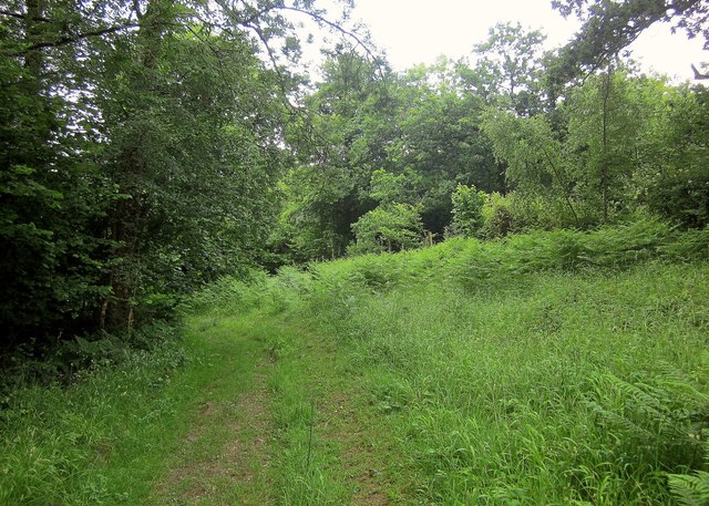
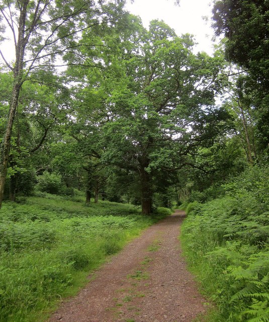
The woodland is primarily composed of native tree species such as oak, beech, and ash, creating a diverse and vibrant ecosystem. The canopy of the trees provides a shaded and tranquil environment, making it an ideal destination for nature enthusiasts and those seeking peaceful walks.

Deanend Bushes is home to a wide variety of fauna, including several species of birds, mammals, and insects. The woodland provides a habitat for creatures such as woodpeckers, owls, deer, foxes, and badgers. Birdwatchers can often spot rare and migratory birds nesting or passing through the area.

The woodland has well-maintained walking trails that meander through the trees, allowing visitors to explore the natural beauty of the forest. These paths are suitable for both casual walkers and more experienced hikers. Along the trails, visitors can discover hidden clearings, babbling brooks, and occasional glimpses of wildlife.

Deanend Bushes is a popular destination for outdoor activities such as picnicking, photography, and nature study. The management of the woodland ensures the preservation of its natural features while offering an accessible and enjoyable experience for visitors of all ages.

If you have any feedback on the listing, please let us know in the comments section below.

Deanend Bushes Images

Images are sourced within 2km of 50.959403/-2.0400014 or Grid Reference ST9717. Thanks to Geograph Open Source API. All images are credited.

Longcroft Road Footpath BSJO 19 follows this track through Long Croft in Chase Woods.
Longcroft Road
Footpath BSJO 19 follows this track through Long Croft in Chase Woods.
Chase Avenue Crossing Longcroft Road, which I am following. Chase Avenue is one of a pair of beech avenues created by Augustus Pitt Rivers as an extension to his Rushmore estate in the late C19.
Chase Avenue
Crossing Longcroft Road, which I am following. Chase Avenue is one of a pair of beech avenues created by Augustus Pitt Rivers as an extension to his Rushmore estate in the late C19.
Path, Great Shaftesbury Coppice Approaching the forest edge shown in <a href="https://www.geograph.org.uk/photo/4544846">ST9718 : Little Shaftesbury Coppice</a>.
Path, Great Shaftesbury Coppice
Approaching the forest edge shown in ST9718 : Little Shaftesbury Coppice.
Track by Great Shaftesbury Coppice Bridleway E52 23 runs alongside the edge of Chase Woods. This looks in the other direction from the same spot as <a href="https://www.geograph.org.uk/photo/4544846">ST9718 : Little Shaftesbury Coppice</a>.
Track by Great Shaftesbury Coppice
Bridleway E52 23 runs alongside the edge of Chase Woods. This looks in the other direction from the same spot as ST9718 : Little Shaftesbury Coppice.
Shire Rack The path follows the county boundary between Dorset and Wiltshire.
Shire Rack
The path follows the county boundary between Dorset and Wiltshire.
Shire Rack The path follows the county boundary between Dorset and Wiltshire, although since it is a Dorset path (E52 30) the boundary must be on the left side.
Shire Rack
The path follows the county boundary between Dorset and Wiltshire, although since it is a Dorset path (E52 30) the boundary must be on the left side.
Longcroft Road The track is followed here by footpath E52 26 as it begins to near Newtown, traversing Chase Woods for about three kilometres.
Longcroft Road
The track is followed here by footpath E52 26 as it begins to near Newtown, traversing Chase Woods for about three kilometres.
Lane, Newtown Continuing the line of Longcroft road through Chase Woods. <a href="https://www.geograph.org.uk/photo/4545300">ST9818 : Houses at Newtown</a> was taken just a little further along this lane.
Lane, Newtown
Continuing the line of Longcroft road through Chase Woods. ST9818 : Houses at Newtown was taken just a little further along this lane.
Parkland east of Oakley Lane Part of Rushmore Park.
Parkland east of Oakley Lane
Part of Rushmore Park.
B3081 looking east Heading towards Sixpenny Handley.
B3081 looking east
Heading towards Sixpenny Handley.
Rushmore Park, avenue The remains of a once fine avenue of beech trees, at the southern entrance to the estate.
Rushmore Park, avenue
The remains of a once fine avenue of beech trees, at the southern entrance to the estate.
Rushmore Park, avenue A once fine avenue of beech trees leading from South Lodge. Several have disappeared or are in poor condition.
Rushmore Park, avenue
A once fine avenue of beech trees leading from South Lodge. Several have disappeared or are in poor condition.
Rushmore Park, platform Possibly used for watching equestrian events.
Rushmore Park, platform
Possibly used for watching equestrian events.
Rushmore Park, gate Entering Pollards Wood, on the path to Shermel Gate.
Rushmore Park, gate
Entering Pollards Wood, on the path to Shermel Gate.
Rushmore Park, footpath Through Pollards Wood, on the way to Shermel Gate; part of Hardy Way.
Rushmore Park, footpath
Through Pollards Wood, on the way to Shermel Gate; part of Hardy Way.
Rushmore Park, bluebells Wild bluebells under, unusually, a screen of conifers in Uddens Coppice.
Rushmore Park, bluebells
Wild bluebells under, unusually, a screen of conifers in Uddens Coppice.
Rushmore Park, marker On the path through Uddens Coppice towards Shermel Gate; on Hardy Way.
Rushmore Park, marker
On the path through Uddens Coppice towards Shermel Gate; on Hardy Way.
Rushmore Park, bluebell wood Wild bluebells in Brookes Coppice.
Rushmore Park, bluebell wood
Wild bluebells in Brookes Coppice.
Show me another place!

Deanend Bushes is located at Grid Ref: ST9717 (Lat: 50.959403, Lng: -2.0400014)

Unitary Authority: Dorset

Police Authority: Dorset

What 3 Words

///headache.collide.blip. Near Bower Chalke, Wiltshire

Related Wikis

Cranborne Chase and West Wiltshire Downs

Cranborne Chase and West Wiltshire Downs is an Area of Outstanding Natural Beauty (AONB) covering 379 square miles (980 km2) of Dorset, Hampshire, Somerset...

Cranborne Chase

Cranborne Chase (grid reference ST970180) is an area of central southern England, straddling the counties Dorset, Hampshire and Wiltshire. It is part of...

Woodcutts

Woodcutts is a hamlet within the parish of Sixpenny Handley and is located in the north of Dorset, near to the Wiltshire border. Originally named "Woodcotes...

Woodcutts Settlement

Woodcutts Settlement is an archaeological site of the late Iron Age and Romano-British period on Cranborne Chase, England. It is situated about 1 mile...

Nearby Amenities

Located within 500m of 50.959403,-2.0400014
Ridingway
Place: locality
Lat/Long: 50.9632717/-2.0376044
Withywind Coppice
Place: locality
Lat/Long: 50.961502/-2.038126
Brockwell Coppice
Place: locality
Lat/Long: 50.9592553/-2.0364099
Deanend Bushes
Place: locality
Lat/Long: 50.9588102/-2.0397412
Chaffinger's Coppice
Place: locality
Lat/Long: 50.9583015/-2.0422482
Deanend
Place: hamlet
Lat/Long: 50.955758/-2.0383448
Scrubbity Coppice
Place: locality
Lat/Long: 50.9612583/-2.0422987
The data included in this document is from www.openstreetmap.org. The data is made available under ODbL.

Have you been to Deanend Bushes?

Leave your review of Deanend Bushes below (or comments, questions and feedback).