Tinkley Coppice
Wood, Forest in Wiltshire
England
Tinkley Coppice
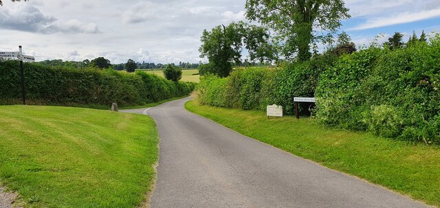
Tinkley Coppice is a picturesque woodland located in the county of Wiltshire, England. This beautiful forest covers an area of approximately 60 acres and is situated near the village of Lacock, renowned for its charming medieval architecture and historic abbey.
The woodland is predominantly made up of deciduous trees, such as oak, beech, and ash, which create a vibrant and ever-changing landscape throughout the seasons. Tinkley Coppice is known for its rich biodiversity, with a variety of plants, fungi, and wildlife thriving within its boundaries. It provides a vital habitat for numerous species, including deer, foxes, badgers, and a wide range of bird species, making it a popular spot for nature enthusiasts and birdwatchers.
The forest is crisscrossed with a network of well-maintained footpaths and trails, allowing visitors to explore its natural beauty on foot. These paths meander through the woods, offering glimpses of tranquil streams, wildflowers, and ancient woodland features. Tinkley Coppice offers a peaceful retreat for those seeking a break from the hustle and bustle of everyday life, providing a serene and calming atmosphere.
The woodland is managed by the National Trust, ensuring its preservation for future generations to enjoy. It is open to the public year-round, with no admission fee, making it a popular destination for families, hikers, and nature lovers alike. Whether you are seeking a leisurely stroll, a picnic among nature, or a chance to spot some of the local wildlife, Tinkley Coppice is a must-visit destination for anyone exploring the natural wonders of Wiltshire.
If you have any feedback on the listing, please let us know in the comments section below.
Tinkley Coppice Images
Images are sourced within 2km of 50.960658/-2.0682379 or Grid Reference ST9517. Thanks to Geograph Open Source API. All images are credited.


Tinkley Coppice is located at Grid Ref: ST9517 (Lat: 50.960658, Lng: -2.0682379)
Unitary Authority: Wiltshire
Police Authority: Wiltshire
What 3 Words
///swooning.slide.laminate. Near Bower Chalke, Wiltshire
Nearby Locations
Related Wikis

Sandroyd School
Sandroyd School is an independent co-educational preparatory school for day and boarding pupils aged 2 to 13 in the south of Wiltshire, England. The school...

South Lodge Camp
South Lodge Camp is an archaeological site of the Bronze Age, about 0.6 miles (1.0 km) south-east of the village of Tollard Royal, in Wiltshire, England...

Tollard Royal
Tollard Royal is a village and civil parish on Cranborne Chase, Wiltshire, England. The parish is on Wiltshire's southern boundary with Dorset and the...

King John's House, Tollard Royal
King John's House is a former manor house in the south Wiltshire village of Tollard Royal, England. Just south of the church, the building has at its core...

Woodcutts Settlement
Woodcutts Settlement is an archaeological site of the late Iron Age and Romano-British period on Cranborne Chase, England. It is situated about 1 mile...

Larmer Tree Festival
Larmer Tree Festival was a three-day music, comedy and arts festival held annually from 1990 until 2019 at the Larmer Tree Gardens, near Tollard Royal...

Larmer Tree Gardens
The Larmer Tree Gardens near Tollard Royal in south Wiltshire, England, were created by landowner Augustus Pitt Rivers in 1880 as pleasure grounds for...

Rotherley Down Settlement
Rotherley Down Settlement is an archaeological site of the late Iron Age and Romano-British period on Cranborne Chase, England. It is about 1.5 miles...
Nearby Amenities
Located within 500m of 50.960658,-2.0682379Have you been to Tinkley Coppice?
Leave your review of Tinkley Coppice below (or comments, questions and feedback).