Lodge Coppice

Wood, Forest in Wiltshire

England

Lodge Coppice

Parkland east of Oakley Lane Part of Rushmore Park.
Parkland east of Oakley Lane Credit: Robin Webster

Lodge Coppice is a stunning wooded area located in the county of Wiltshire, England. Situated near the town of Trowbridge, this forested landscape spans over a vast area of approximately 100 acres. It is known for its abundant flora and fauna, providing a haven for nature enthusiasts and outdoor lovers alike.

The woodland in Lodge Coppice is predominantly comprised of deciduous trees, such as oak, beech, and ash, which create a beautiful canopy overhead. Within this lush greenery, various species of wildflowers can be found, adding splashes of color to the forest floor during the spring and summer months.

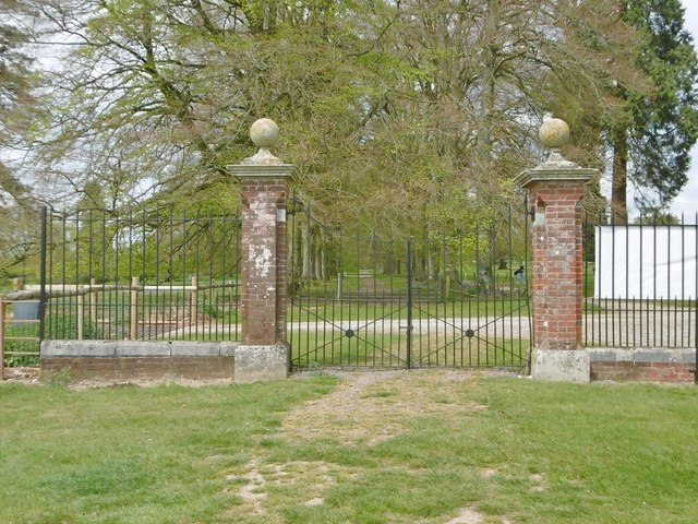
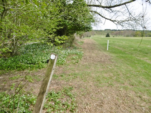
The forest is crisscrossed with well-maintained walking trails, allowing visitors to explore its natural beauty at their leisure. These paths wind through the thick foliage, leading adventurers to discover hidden clearings, babbling brooks, and even a small pond teeming with aquatic life.

Lodge Coppice is home to a diverse range of wildlife, making it an ideal location for birdwatching and animal spotting. Visitors may catch glimpses of deer, badgers, foxes, and a variety of bird species, including woodpeckers, owls, and warblers.

The forest is open to the public year-round, offering a peaceful and serene escape from the hustle and bustle of everyday life. Whether one seeks solitude, a leisurely stroll, or a picnic surrounded by nature, Lodge Coppice provides a tranquil retreat for all who visit.

If you have any feedback on the listing, please let us know in the comments section below.

Lodge Coppice Images

Images are sourced within 2km of 50.964793/-2.0710777 or Grid Reference ST9518. Thanks to Geograph Open Source API. All images are credited.

Parkland east of Oakley Lane Part of Rushmore Park.
Parkland east of Oakley Lane
Part of Rushmore Park.
B3081 looking east Heading towards Sixpenny Handley.
B3081 looking east
Heading towards Sixpenny Handley.
Rushmore Park, avenue The remains of a once fine avenue of beech trees, at the southern entrance to the estate.
Rushmore Park, avenue
The remains of a once fine avenue of beech trees, at the southern entrance to the estate.
Rushmore Park, timber Beech trunks, awaiting collection by the roadside.
Rushmore Park, timber
Beech trunks, awaiting collection by the roadside.
Rushmore Park, footpath Skirting woodland, towards Shermel Gate.
Rushmore Park, footpath
Skirting woodland, towards Shermel Gate.
Rushmore Park, avenue A once fine avenue of beech trees leading from South Lodge. Several have disappeared or are in poor condition.
Rushmore Park, avenue
A once fine avenue of beech trees leading from South Lodge. Several have disappeared or are in poor condition.
Rushmore Park, platform Possibly used for watching equestrian events.
Rushmore Park, platform
Possibly used for watching equestrian events.
Rushmore Park, gate Entering Pollards Wood, on the path to Shermel Gate.
Rushmore Park, gate
Entering Pollards Wood, on the path to Shermel Gate.
Rushmore Park, footpath Through Pollards Wood, on the way to Shermel Gate; part of Hardy Way.
Rushmore Park, footpath
Through Pollards Wood, on the way to Shermel Gate; part of Hardy Way.
Rushmore Park, bluebells Wild bluebells under, unusually, a screen of conifers in Uddens Coppice.
Rushmore Park, bluebells
Wild bluebells under, unusually, a screen of conifers in Uddens Coppice.
Rushmore Park, marker On the path through Uddens Coppice towards Shermel Gate; on Hardy Way.
Rushmore Park, marker
On the path through Uddens Coppice towards Shermel Gate; on Hardy Way.
Rushmore Park, bluebell wood Wild bluebells in Brookes Coppice.
Rushmore Park, bluebell wood
Wild bluebells in Brookes Coppice.
Rushmore Park, golf course Part of an extensive 18-hole course: <span class="nowrap"><a title="http://www.rushmoregolfclub.co.uk/cms/" rel="nofollow ugc noopener" href="http://www.rushmoregolfclub.co.uk/cms/">Link</a><img style="margin-left:2px;" alt="External link" title="External link - shift click to open in new window" src="https://s1.geograph.org.uk/img/external.png" width="10" height="10"/></span>
Rushmore Park, golf course
Part of an extensive 18-hole course: LinkExternal link
Rushmore Park, dewpond Used by the local sheep.
Rushmore Park, dewpond
Used by the local sheep.
Rushmore Park, bluebells Wild bluebells next to the golf course.
Rushmore Park, bluebells
Wild bluebells next to the golf course.
Rushmore Park, golf course An extensive 18-hole course: <span class="nowrap"><a title="http://www.rushmoregolfclub.co.uk/cms/" rel="nofollow ugc noopener" href="http://www.rushmoregolfclub.co.uk/cms/">Link</a><img style="margin-left:2px;" alt="External link" title="External link - shift click to open in new window" src="https://s1.geograph.org.uk/img/external.png" width="10" height="10"/></span>
Rushmore Park, golf course
An extensive 18-hole course: LinkExternal link
Rushmore Park, gateway Also on the Wiltshire/Dorset boundary.
Rushmore Park, gateway
Also on the Wiltshire/Dorset boundary.
Rushmore Park, marker On the footpath to Shermel Gate, part of Hardy Way. Beware golf balls from the right!
Rushmore Park, marker
On the footpath to Shermel Gate, part of Hardy Way. Beware golf balls from the right!
Show me another place!

Lodge Coppice is located at Grid Ref: ST9518 (Lat: 50.964793, Lng: -2.0710777)

Unitary Authority: Wiltshire

Police Authority: Wiltshire

What 3 Words

///shudders.steers.bashful. Near Ansty, Wiltshire

Related Wikis

Sandroyd School

Sandroyd School is an independent co-educational preparatory school for day and boarding pupils aged 2 to 13 in the south of Wiltshire, England. The school...

Tollard Royal

Tollard Royal is a village and civil parish on Cranborne Chase, Wiltshire, England. The parish is on Wiltshire's southern boundary with Dorset and the...

King John's House, Tollard Royal

King John's House is a former manor house in the south Wiltshire village of Tollard Royal, England. Just south of the church, the building has at its core...

South Lodge Camp

South Lodge Camp is an archaeological site of the Bronze Age, about 0.6 miles (1.0 km) south-east of the village of Tollard Royal, in Wiltshire, England...

Rotherley Down Settlement

Rotherley Down Settlement is an archaeological site of the late Iron Age and Romano-British period on Cranborne Chase, England. It is about 1.5 miles...

Woodcutts Settlement

Woodcutts Settlement is an archaeological site of the late Iron Age and Romano-British period on Cranborne Chase, England. It is situated about 1 mile...

Rotherley Downs

Rotherley Downs (grid reference ST946196) is a 120.05 hectare biological Site of Special Scientific Interest in Wiltshire, England, notified in 1989. The...

Larmer Tree Festival

Larmer Tree Festival was a three-day music, comedy and arts festival held annually from 1990 until 2019 at the Larmer Tree Gardens, near Tollard Royal...

Related Videos

Chalk Escape Walking Festival at Larmer Tree Gardens - Cranborne Chase AONB

For more info about upcoming events see: https://cranbornechase.org.uk Cranborne Chase AONB run the ChalkEscape Walking ...

WALKS IN WILTSHIRE at TOLLARD ROYAL & WIN GREEN (CLOSE TO THE WILTSHIRE / DORSET BORDER).

In this episode of my series “ Walks in Wiltshire”, I take a walk in & around the village of Tollard Royal which is located very close ...

Walk and Cook #2 | Iron Age Hill Fort! (Cranborne Chase) | Day hike with lunch | using Firebox Nano

A walk around the Cranborne Chase area of Southern England. Some interesting history along the way, and best of all - cooked ...

Nearby Amenities

Located within 500m of 50.964793,-2.0710777
Entrance: yes
Lat/Long: 50.9651563/-2.0682643
Material: wood
Power: pole
Source: bing
Lat/Long: 50.9624587/-2.0768214
Material: wood
Power: pole
Source: bing
Lat/Long: 50.9627999/-2.0756654
Material: wood
Power: pole
Source: bing
Lat/Long: 50.9631547/-2.0744959
Material: wood
Power: pole
Source: bing
Lat/Long: 50.9637493/-2.0738978
Material: wood
Power: pole
Source: bing
Lat/Long: 50.9643879/-2.0732728
Material: wood
Power: pole
Source: bing
Lat/Long: 50.9650889/-2.0726479
Material: wood
Power: pole
Source: bing
Lat/Long: 50.9657646/-2.0720471
Material: wood
Power: pole
Source: bing
Lat/Long: 50.9664605/-2.0713926
Material: wood
Power: pole
Source: bing
Lat/Long: 50.967121/-2.0698745
Material: wood
Power: pole
Source: bing
Lat/Long: 50.9674335/-2.0706496
Material: wood
Power: pole
Source: bing
Lat/Long: 50.9683963/-2.0701132
Material: wood
Power: pole
Source: bing
Lat/Long: 50.9687325/-2.0694883
Lodge Coppice
Place: locality
Lat/Long: 50.9651657/-2.0713868
The data included in this document is from www.openstreetmap.org. The data is made available under ODbL.

Have you been to Lodge Coppice?

Leave your review of Lodge Coppice below (or comments, questions and feedback).