Nethermore Wood
Wood, Forest in Wiltshire
England
Nethermore Wood
Nethermore Wood is a picturesque woodland located in the county of Wiltshire, in the southern part of England. Covering an area of approximately 300 acres, this enchanting forest is known for its diverse range of flora and fauna, making it a popular destination for nature enthusiasts and hikers alike.
The wood is primarily composed of a mix of deciduous and evergreen trees, including oak, beech, ash, and pine, which create a vibrant and tranquil atmosphere throughout the year. The forest floor is adorned with an array of wildflowers, including bluebells and primroses, adding a splash of color to the landscape.
Nethermore Wood offers a variety of walking trails, ranging from easy strolls to more challenging hikes, catering to different levels of fitness and interests. Along these paths, visitors may encounter a variety of wildlife, such as deer, foxes, badgers, and a diverse range of bird species. The forest also provides a habitat for numerous insects and small mammals.
In addition to its natural beauty, Nethermore Wood is also steeped in history. It is believed that the woodland has been in existence for centuries, and remnants of ancient settlements can still be found within its boundaries. The wood has also been used as a source of timber over the years, which has contributed to its well-managed and sustainable ecosystem.
Overall, Nethermore Wood is a haven of tranquility and natural beauty, offering visitors the opportunity to immerse themselves in the wonders of the English countryside while enjoying the rich biodiversity and historical significance of the area.
If you have any feedback on the listing, please let us know in the comments section below.
Nethermore Wood Images
Images are sourced within 2km of 51.419277/-2.0771039 or Grid Reference ST9468. Thanks to Geograph Open Source API. All images are credited.
![Bowood House and gardens [41] Looking across the golf course to the clubrooms and hotel. Seen from the footpath.
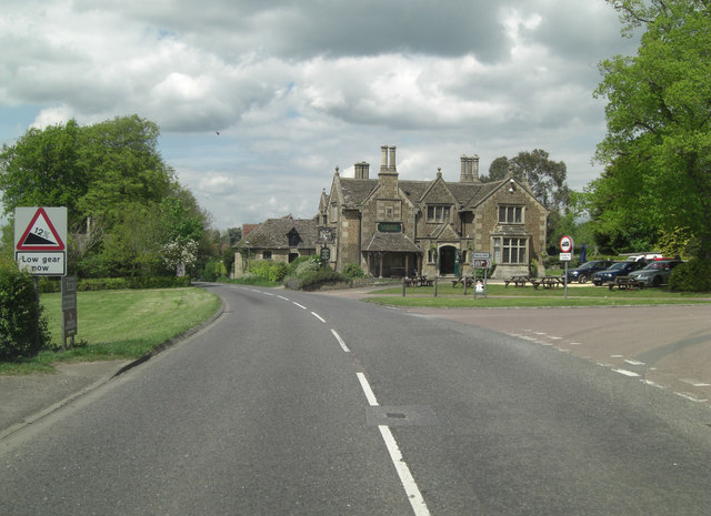
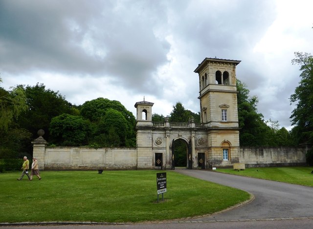
Bowood is a Georgian country house of circa 1754 with interiors by Robert Adam and a garden designed by Lancelot &#039;Capability&#039; Brown. The existing house is only a small part of the original building which was mostly derelict after use by the RAF and as a school and it was demolished in 1956. Bowood is the home of the Marquis of Lansdowne and it has been open to the public since 1975. The house is listed, grade I, with much detail at: <span class="nowrap"><a title="https://historicengland.org.uk/listing/the-list/list-entry/1253268" rel="nofollow ugc noopener" href="https://historicengland.org.uk/listing/the-list/list-entry/1253268">Link</a><img style="margin-left:2px;" alt="External link" title="External link - shift click to open in new window" src="https://s1.geograph.org.uk/img/external.png" width="10" height="10"/></span> The garden, amounting to some 550 hectares, is on the Register of Historic Parks and Gardens, grade I, with much history and detail at: <span class="nowrap"><a title="https://historicengland.org.uk/listing/the-list/list-entry/1000336" rel="nofollow ugc noopener" href="https://historicengland.org.uk/listing/the-list/list-entry/1000336">Link</a><img style="margin-left:2px;" alt="External link" title="External link - shift click to open in new window" src="https://s1.geograph.org.uk/img/external.png" width="10" height="10"/></span>](https://s2.geograph.org.uk/geophotos/07/04/90/7049086_135a8725.jpg)
![Bowood House and gardens [42] A closer look at the clubhouse, seen from the footpath.
Bowood is a Georgian country house of circa 1754 with interiors by Robert Adam and a garden designed by Lancelot &#039;Capability&#039; Brown. The existing house is only a small part of the original building which was mostly derelict after use by the RAF and as a school and it was demolished in 1956. Bowood is the home of the Marquis of Lansdowne and it has been open to the public since 1975. The house is listed, grade I, with much detail at: <span class="nowrap"><a title="https://historicengland.org.uk/listing/the-list/list-entry/1253268" rel="nofollow ugc noopener" href="https://historicengland.org.uk/listing/the-list/list-entry/1253268">Link</a><img style="margin-left:2px;" alt="External link" title="External link - shift click to open in new window" src="https://s1.geograph.org.uk/img/external.png" width="10" height="10"/></span> The garden, amounting to some 550 hectares, is on the Register of Historic Parks and Gardens, grade I, with much history and detail at: <span class="nowrap"><a title="https://historicengland.org.uk/listing/the-list/list-entry/1000336" rel="nofollow ugc noopener" href="https://historicengland.org.uk/listing/the-list/list-entry/1000336">Link</a><img style="margin-left:2px;" alt="External link" title="External link - shift click to open in new window" src="https://s1.geograph.org.uk/img/external.png" width="10" height="10"/></span>](https://s3.geograph.org.uk/geophotos/07/04/90/7049087_e2ba8617.jpg)
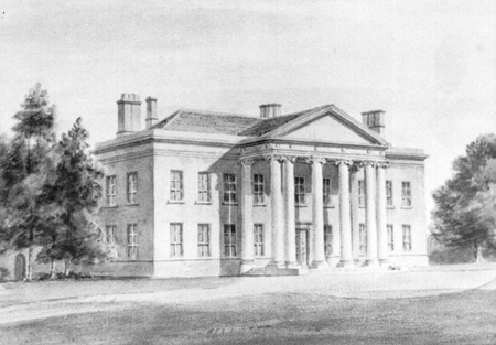
![A glimpse of Pewsham House [1] Seen from the bridleway is this tantalizing glimpse of Pewsham House, a delightful red brick house built in 1892. Listed grade II with details at <span class="nowrap"><a title="http://list.english-heritage.org.uk/resultsingle.aspx?uid=1239933" rel="nofollow ugc noopener" href="http://list.english-heritage.org.uk/resultsingle.aspx?uid=1239933">Link</a><img style="margin-left:2px;" alt="External link" title="External link - shift click to open in new window" src="https://s1.geograph.org.uk/img/external.png" width="10" height="10"/></span>](https://s2.geograph.org.uk/geophotos/04/26/94/4269422_473ff1ba.jpg)

Nethermore Wood is located at Grid Ref: ST9468 (Lat: 51.419277, Lng: -2.0771039)
Unitary Authority: Wiltshire
Police Authority: Wiltshire
What 3 Words
///glad.blacken.dignify. Near Lacock, Wiltshire
Nearby Locations
Related Wikis

Bowden Hill
Bowden Hill is a village in Wiltshire, England, in Lacock parish about 3+1⁄2 miles (6 km) south of Chippenham and 1+1⁄2 miles (2.4 km) to the east of Lacock...
Spye Park
Spye Park is a former country estate in Bromham parish in Wiltshire, England. It lies north of Chittoe, about 1.5 miles (2.4 km) north-west of Bromham...

Bewley Common
Bewley Common is a hamlet in Wiltshire, England. It lies in the civil parish of Lacock, west of Bowden Hill and about 1 mile (1.6 km) east of Lacock village...

Sandy Lane, Wiltshire
Sandy Lane is a small village in Wiltshire, England, about 4.5 miles (7 km) south-east of Chippenham and 3 miles (5 km) south-west of Calne. It lies on...
Nearby Amenities
Located within 500m of 51.419277,-2.0771039Have you been to Nethermore Wood?
Leave your review of Nethermore Wood below (or comments, questions and feedback).