Halfmile Wood

Wood, Forest in Northumberland

England

Halfmile Wood

Hexham: on Market Street Ashbourne House Antiques is in the centre of the picture. The steelwork on the left appears more clearly in <a href="https://www.geograph.org.uk/photo/6900486">NY9364 : Hexham: swimming bath to flats</a>.
Hexham: on Market Street Credit: John Sutton

Halfmile Wood is a picturesque woodland located in the county of Northumberland in northern England. Covering an area of approximately 200 acres, it is nestled within the stunning Northumbrian countryside, renowned for its natural beauty and rich biodiversity. The wood is situated about half a mile (hence the name) south of the village of Halfmile, making it easily accessible for locals and visitors alike.

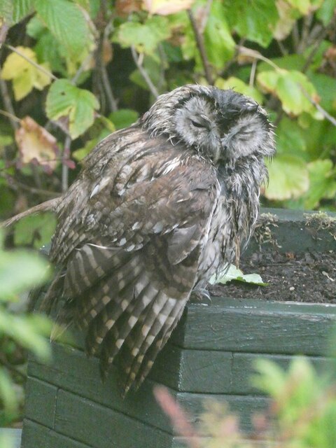
Halfmile Wood is primarily composed of native tree species such as oak, beech, and birch, creating a diverse and vibrant ecosystem. The dense canopy provides a haven for numerous bird species, including woodpeckers, owls, and various songbirds. It is also home to a variety of small mammals, such as squirrels, badgers, and foxes.

The wood features a network of well-maintained footpaths, allowing visitors to explore its natural wonders at their own pace. Walking through the woodland, visitors can enjoy the peaceful atmosphere and admire the striking seasonal displays of wildflowers and vibrant foliage.

Halfmile Wood is a popular destination for nature enthusiasts, walkers, and photographers, who are attracted by its tranquility and the opportunity to observe wildlife in its natural habitat. The wood offers a range of recreational activities, such as picnicking, wildlife spotting, and nature photography.

With its idyllic setting and abundant wildlife, Halfmile Wood is a true gem of Northumberland, providing a serene escape from the hustle and bustle of everyday life. Whether one seeks a peaceful stroll or a chance to immerse themselves in nature, this woodland offers an enchanting experience for all who visit.

If you have any feedback on the listing, please let us know in the comments section below.

Halfmile Wood Images

Images are sourced within 2km of 54.963391/-2.0851501 or Grid Reference NY9463. Thanks to Geograph Open Source API. All images are credited.

Hexham: on Market Street Ashbourne House Antiques is in the centre of the picture. The steelwork on the left appears more clearly in <a href="https://www.geograph.org.uk/photo/6900486">NY9364 : Hexham: swimming bath to flats</a>.
Hexham: on Market Street
Ashbourne House Antiques is in the centre of the picture. The steelwork on the left appears more clearly in NY9364 : Hexham: swimming bath to flats.
Benchmark on NW parapet of A6079 railway bridge Ordnance Survey cut mark benchmark levelled at 40.610m above Newlyn Datum verified 1961
Benchmark on NW parapet of A6079 railway bridge
Ordnance Survey cut mark benchmark levelled at 40.610m above Newlyn Datum verified 1961
Bridge taking A6079 over railway line NW of Hexham Station There is an Ordnance Survey benchmark <a href="https://www.geograph.org.uk/photo/6941663">NY9364 : Benchmark on NW parapet of A6079 railway bridge</a> at the base of the parapet pier on the left hand side of the bridge
Bridge taking A6079 over railway line NW of Hexham Station
There is an Ordnance Survey benchmark NY9364 : Benchmark on NW parapet of A6079 railway bridge at the base of the parapet pier on the left hand side of the bridge
Market Place, Hexham
Construction site on SW side of railway NW of Hexham Station
Matfen bus approaching A6079 bridge over railway NW of Hexham Station
Class 156 diesel multiple unit at Hexham Station forming the 1612 to Carlisle
St Wilfrid's Gateway A grade I listed structure. For details see link to entry on the Historic England website <span class="nowrap"><a title="https://historicengland.org.uk/listing/the-list/list-entry/1042616" rel="nofollow ugc noopener" href="https://historicengland.org.uk/listing/the-list/list-entry/1042616">Link</a><img style="margin-left:2px;" alt="External link" title="External link - shift click to open in new window" src="https://s1.geograph.org.uk/img/external.png" width="10" height="10"/></span>
St Wilfrid's Gateway
A grade I listed structure. For details see link to entry on the Historic England website LinkExternal link
A view to the east from Hexham railway station Some sections of the line between Newcastle and Carlisle retain their mechanical semaphore signalling, as here at Hexham. The 1896 signal box stands on a gantry above the track and is Grade II listed.
A view to the east from Hexham railway station
Some sections of the line between Newcastle and Carlisle retain their mechanical semaphore signalling, as here at Hexham. The 1896 signal box stands on a gantry above the track and is Grade II listed.
A freight train approaching Hexham station Hauling a short train of container flats. Framed by the A6079 Rotary Way road bridge. The left-hand span of the bridge once accommodated tracks into a small goods yard, which stood next to the station.
A freight train approaching Hexham station
Hauling a short train of container flats. Framed by the A6079 Rotary Way road bridge. The left-hand span of the bridge once accommodated tracks into a small goods yard, which stood next to the station.
Young Tawny Owl Almost asleep in broad daylight in a garden in Loughbrow Park.
Young Tawny Owl
Almost asleep in broad daylight in a garden in Loughbrow Park.
Wentworth Leisure Centre, Hexham
The bund on Wydon Water Seen from Intake Lane.
The bund on Wydon Water
Seen from Intake Lane.
Wydon Water Wydon Water was constructed to protect parts of Hexham town from flooding. The reservoir is flanked by a number of fishing stages. The bund is to the left.
Wydon Water
Wydon Water was constructed to protect parts of Hexham town from flooding. The reservoir is flanked by a number of fishing stages. The bund is to the left.
Wydon Water Wydon Water was constructed to protect parts of Hexham town from flooding. The reservoir is flanked by a number of fishing stages. A number of mallards are resident. The bund is seen across the water.
Wydon Water
Wydon Water was constructed to protect parts of Hexham town from flooding. The reservoir is flanked by a number of fishing stages. A number of mallards are resident. The bund is seen across the water.
Mallards on Wydon Water Wydon Water was constructed to protect parts of Hexham town from flooding. The reservoir is flanked by a number of fishing stages.
Mallards on Wydon Water
Wydon Water was constructed to protect parts of Hexham town from flooding. The reservoir is flanked by a number of fishing stages.
Mallards on Wydon Water
Wydon Water Wydon Water was constructed to protect parts of Hexham town from flooding. The bund is seen across the water.
Wydon Water
Wydon Water was constructed to protect parts of Hexham town from flooding. The bund is seen across the water.
Show me another place!

Halfmile Wood is located at Grid Ref: NY9463 (Lat: 54.963391, Lng: -2.0851501)

Unitary Authority: Northumberland

Police Authority: Northumbria

What 3 Words

///formally.liners.newspaper. Near Hexham, Northumberland

Related Wikis

Hexham General Hospital

Hexham General Hospital is an acute general hospital in Hexham, Northumberland, England. It is managed by the Northumbria Healthcare NHS Foundation Trust...

Battle of Hexham

The Battle of Hexham, 15 May 1464, marked the end of significant Lancastrian resistance in the north of England during the early part of the reign of Edward...

Hexham railway station

Hexham is a railway station on the Tyne Valley Line, which runs between Newcastle and Carlisle via Hexham. The station, situated 22 miles 22 chains (22...

Hexham Old Gaol

The Old Gaol, also known as the Manor Office, is a custodial building in Hallgate in Hexham, Northumberland, England. The building, which now operates...

Hexham

Hexham ( HEKS-əm) is a market town and civil parish in Northumberland, England, on the south bank of the River Tyne, formed by the confluence of the North...

Moot Hall, Hexham

The Moot Hall is a former judicial structure in The Market Place, Hexham, Northumberland, England. The structure, which currently accommodates an art gallery...

Queen's Hall, Hexham

The Queen's Hall, formerly Hexham Town Hall, is a municipal structure in Beaumont Street, Hexham, Northumberland, England. The structure, which was the...

St Mary's Church, Hexham

St Mary's Church is a Roman Catholic Parish church in Hexham, Northumberland. It was built from 1828 to 1830 in the Gothic Revival style. It is located...

Nearby Amenities

Located within 500m of 54.963391,-2.0851501
Turning Circle
Lat/Long: 54.9673791/-2.0881161
Direction: 170
Generator Method: photovoltaic
Generator Output Electricity: yes
Generator Source: solar
Generator Type: solar_photovoltaic_panel
Location: roof
Power: generator
Lat/Long: 54.9676516/-2.0870805
Generator Method: photovoltaic
Generator Output Electricity: yes
Generator Source: solar
Generator Type: solar_photovoltaic_panel
Location: roof
Power: generator
Lat/Long: 54.9673774/-2.0864555
Generator Method: photovoltaic
Generator Output Electricity: yes
Generator Source: solar
Generator Type: solar_photovoltaic_panel
Location: roof
Power: generator
Lat/Long: 54.9676523/-2.0869707
Generator Method: photovoltaic
Generator Output Electricity: yes
Generator Source: solar
Generator Type: solar_photovoltaic_panel
Location: roof
Power: generator
Lat/Long: 54.9675434/-2.0829152
Barrier: stile
Foot: yes
Material: wood
Step Count: 2
Stile: stepover
Lat/Long: 54.9664323/-2.0828092
Barrier: kissing_gate
Lat/Long: 54.9654845/-2.0834596
The data included in this document is from www.openstreetmap.org. The data is made available under ODbL.

Have you been to Halfmile Wood?

Leave your review of Halfmile Wood below (or comments, questions and feedback).