Bankhey Wood

Wood, Forest in Lancashire

England

Bankhey Wood
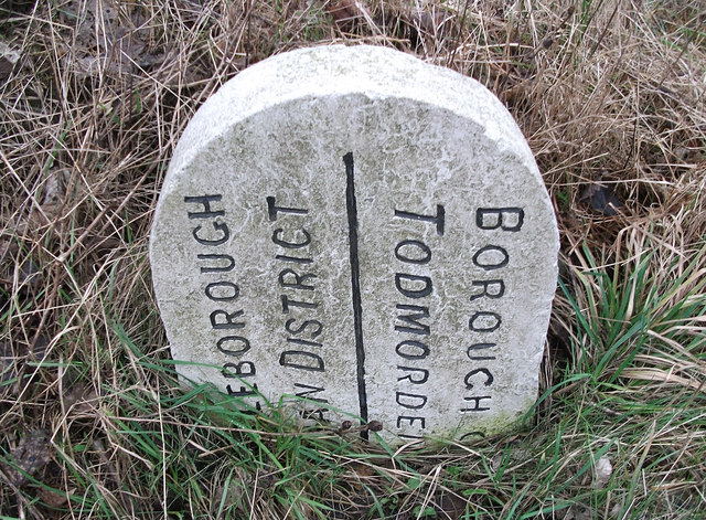
Boundary stone on Todmorden Road Marks the division of the old Littleborough Urban District and the Borough of Todmorden. Now the local authorities are Rochdale and Calderdale respectively. Or, in tribal terms, the boundary between Lancashire and Yorkshire.
Boundary stone on Todmorden Road Credit: michael ely

Bankhey Wood is a picturesque woodland located in the county of Lancashire, England. Covering an area of approximately 10 acres, this woodland is a haven for nature enthusiasts and those seeking tranquility amidst nature's beauty.

Situated in the heart of the Lancashire countryside, Bankhey Wood is known for its diverse range of tree species, including oak, birch, beech, and ash. These towering trees create a dense canopy, allowing only dappled sunlight to filter through, creating an enchanting atmosphere. The forest floor is carpeted with a variety of wildflowers, such as bluebells and primroses, adding bursts of color to the surroundings.

The wood is crisscrossed by a network of well-maintained footpaths, providing visitors with the opportunity to explore its natural wonders. As they wander through the woodland, visitors may come across a babbling brook that meanders through the heart of the wood, adding to the tranquility of the environment.

Bankhey Wood is also home to a rich array of wildlife. Birdwatchers will delight in spotting various species of woodland birds, including woodpeckers, nuthatches, and thrushes. Mammals such as deer, foxes, and rabbits can also be spotted in the wood, making it a popular destination for wildlife enthusiasts.

With its natural beauty and peaceful ambiance, Bankhey Wood offers a serene escape from the hustle and bustle of everyday life. Whether it's a leisurely stroll or a more adventurous hike, this woodland provides a delightful experience for all who visit.

If you have any feedback on the listing, please let us know in the comments section below.

Bankhey Wood Images

Images are sourced within 2km of 53.679922/-2.0882245 or Grid Reference SD9420. Thanks to Geograph Open Source API. All images are credited.

Boundary stone on Todmorden Road Marks the division of the old Littleborough Urban District and the Borough of Todmorden. Now the local authorities are Rochdale and Calderdale respectively. Or, in tribal terms, the boundary between Lancashire and Yorkshire.
Boundary stone on Todmorden Road
Marks the division of the old Littleborough Urban District and the Borough of Todmorden. Now the local authorities are Rochdale and Calderdale respectively. Or, in tribal terms, the boundary between Lancashire and Yorkshire.
Longlees Lock, Rochdale Canal Lock no 36 and the start of the summit pound.
Longlees Lock, Rochdale Canal
Lock no 36 and the start of the summit pound.
Towards Light Hazzles Clough and Chelburn Moor
Light Hazzles Farm across the infant River Roch
Light Hazzles Farm
Light Hazzles Farm
Rochdale Way The Rochdale Way atop the dam of Light Hazzles Reservoir.
Rochdale Way
The Rochdale Way atop the dam of Light Hazzles Reservoir.
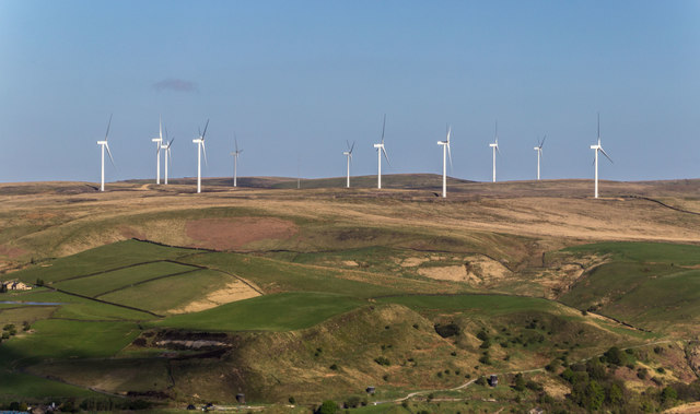
Shore Moor Crook Hill Wind Farm on Shore Moor.
Shore Moor
Crook Hill Wind Farm on Shore Moor.
Pylons and Turbines Looking westwards from the Pennine Way, along the line of pylons crossing Chelburn Moor. The turbines of the Scout Moor Wind Farm can be seen in the distance.
Pylons and Turbines
Looking westwards from the Pennine Way, along the line of pylons crossing Chelburn Moor. The turbines of the Scout Moor Wind Farm can be seen in the distance.
View over Wicken Lowe
Chelburn Moor
Chelburn Moor
Pylons across Wicken Lowe
View towards Littleborough from Chelburn Moor
A6033 at Steanor Bottom Toll House
Footpath on Chelburn Moor
Todmorden Road, Summit, with quarry in the distance The Pennine Bridleway goes left just before the pub. Summit Quarry is a big gash on the far hillside. It started as clay pits for a brickworks.
Todmorden Road, Summit, with quarry in the distance
The Pennine Bridleway goes left just before the pub. Summit Quarry is a big gash on the far hillside. It started as clay pits for a brickworks.
Lock on the Rochdale Canal at Chelburn Bridge, Summit The sign states that this is the West Summit Lock, No.37.
Lock on the Rochdale Canal at Chelburn Bridge, Summit
The sign states that this is the West Summit Lock, No.37.
Entrance to Summit Quarry This started as a clay pit for a brickworks, but there is rock-climbing on gritstone cliffs, so evidently stone has been quarried here. There is also woodland (A 'Woodland Welcome' wood).
Entrance to Summit Quarry
This started as a clay pit for a brickworks, but there is rock-climbing on gritstone cliffs, so evidently stone has been quarried here. There is also woodland (A 'Woodland Welcome' wood).
The Pennine Bridleway climbing away from Summit
Show me another place!

Bankhey Wood is located at Grid Ref: SD9420 (Lat: 53.679922, Lng: -2.0882245)

Unitary Authority: Calderdale

Police Authority: West Yorkshire

What 3 Words

///funnels.eyeliner.usages. Near Walsden, West Yorkshire

Related Wikis

Summit Tunnel

Summit Tunnel in England is one of the world's oldest railway tunnels. It was constructed between 1838 and 1841 by the Manchester and Leeds Railway Company...

Summit Tunnel fire

The Summit Tunnel fire occurred on 20 December 1984, when a dangerous goods train caught fire while passing through the Summit Tunnel on the railway line...

Walsden

Walsden (; WOLZ-dən) is a large village in the civil parish of Todmorden in the Metropolitan Borough of Calderdale, West Yorkshire, England. It was historically...

Walsden railway station

Walsden railway station (; WOLZ-dən) serves the village of Walsden, Todmorden in West Yorkshire, England, on the edge of the Pennines. It is served by...

Calderbrook

Calderbrook ( KAWL-dər-bruuk) is a village within the Metropolitan Borough of Rochdale, in Greater Manchester, England. It was originally part of the township...

Greenvale Brook

Greenvale Brook is a watercourse in Greater Manchester and a tributary of the River Roch. == Tributaries == Lydgate Brook Castle Brook Red Brook Lead Mine...

Mankinholes

Mankinholes is a hamlet in the Metropolitan Borough of Calderdale, in West Yorkshire, England. It is situated in the Pennines and the nearest town is Todmorden...

Todmorden Unitarian Church

Todmorden Unitarian Church is a Unitarian church located in Honey Hole Road, Todmorden, West Yorkshire, England (grid reference SD935239). Built in honour...

Related Videos

Summer Hiking: Gaddings Dam🧗🏻📍🚞

Hi guys!!! Glad to see you again. Enjoy this vlog and drop your comment below.

VISIT TODMORDEN - Wish You Were Here? #todmorden #tourism

Visit Todmorden today. Free parking somewhere, a Lidl and an Aldi. Wish you were here. Music by @UkeofCarl.

A to Z of Todmorden - A is for... #todmorden #tourism

A stroll through the #todmorden alphabet. How many letters can you spot? Music by @thefamousclive.

CENTRE VALE PARK WALKING

Hello Jamie here and with another video. So the day before my birthday, I went to Todmorden, to see family, but also had the ...

Nearby Amenities

Located within 500m of 53.679922,-2.0882245
Seamark Type: gate
Waterway: lock_gate
Lat/Long: 53.6796167/-2.0855526
Seamark Type: gate
Waterway: lock_gate
Lat/Long: 53.679398/-2.0854175
Seamark Type: gate
Waterway: lock_gate
Lat/Long: 53.6778194/-2.0838279
Seamark Type: gate
Waterway: lock_gate
Lat/Long: 53.6780043/-2.0840566
Design: barrel
Power: tower
Lat/Long: 53.6764544/-2.0890748
Design: barrel
Power: tower
Lat/Long: 53.6769966/-2.0908033
Design: barrel
Power: tower
Lat/Long: 53.6780291/-2.0940938
Bus Stop
Rochdale Road
Bus: yes
Local Ref: 45018952
Naptan AtcoCode: 450018952
Naptan Bearing: NW
Naptan CommonName: Rochdale Road
Naptan Crossing: Top o The Close Road
Naptan Indicator: Stop 45018952
Naptan PlusbusZoneRef: LEEDS
Naptan ShortCommonName: Top O The Close Rd
Naptan Street: Rochdale Road
Naptan Verified: no
Public Transport: platform
Shelter: yes
Source: naptan_import
Lat/Long: 53.6835232/-2.0925419
Bus Stop
Rochdale Road
Bus: yes
Local Ref: 45018953
Naptan AtcoCode: 450018953
Naptan Bearing: E
Naptan CommonName: Rochdale Road
Naptan Crossing: Bottomley Road
Naptan Indicator: Stop 45018953
Naptan PlusbusZoneRef: LEEDS
Naptan ShortCommonName: Bottomley Road
Naptan Street: Rochdale Road
Naptan Verified: no
Public Transport: platform
Source: naptan_import
Lat/Long: 53.6835146/-2.0920119
Bus Stop
Rochdale Road
Bus: yes
Local Ref: 45018954
Naptan AtcoCode: 450018954
Naptan Bearing: NW
Naptan CommonName: Rochdale Road
Naptan Crossing: Top O The Close Road
Naptan Indicator: Stop 45018954
Naptan Landmark: Stone House Bridge
Naptan PlusbusZoneRef: LEEDS
Naptan ShortCommonName: Stone House Bridge
Naptan Street: Rochdale Road
Naptan Verified: no
Public Transport: platform
Source: naptan_import
Lat/Long: 53.6825182/-2.0902686
Bus Stop
Rochdale Road
Bus: yes
Local Ref: 45018955
Naptan AtcoCode: 450018955
Naptan Bearing: SW
Naptan CommonName: Rochdale Road
Naptan Crossing: Top O The Close Road
Naptan Indicator: Stop 45018955
Naptan Landmark: Stone House Bridge
Naptan PlusbusZoneRef: LEEDS
Naptan ShortCommonName: Stone House Bridge
Naptan Street: Rochdale Road
Naptan Verified: no
Public Transport: platform
Source: naptan_import
Lat/Long: 53.6824735/-2.0899656
Bus Stop
Rochdale Road
Bench: yes
Bin: no
Bus: yes
Lit: yes
Local Ref: 45018956
Naptan AtcoCode: 450018956
Naptan Bearing: NW
Naptan CommonName: Rochdale Road
Naptan Crossing: Warlands End Gate
Naptan Indicator: Stop 45018956
Naptan Landmark: Bird In Hand PH
Naptan PlusbusZoneRef: LEEDS
Naptan ShortCommonName: Warlands End Gate
Naptan Street: Rochdale Road
Naptan Verified: no
Public Transport: platform
Shelter: yes
Source: naptan_import
Tactile Paving: no
Lat/Long: 53.6779282/-2.0860501
Bus Stop
Rochdale Road
Bus: yes
Local Ref: 45018957
Naptan AtcoCode: 450018957
Naptan Bearing: SE
Naptan CommonName: Rochdale Road
Naptan Crossing: Warland Gate End
Naptan Indicator: Stop 45018957
Naptan PlusbusZoneRef: LEEDS
Naptan ShortCommonName: Warland Gate End
Naptan Street: Rochdale Road
Naptan Verified: no
Public Transport: platform
Source: naptan_import
Lat/Long: 53.677201/-2.0849586
Crossing
Lat/Long: 53.6823315/-2.0899079
Crossing
Bicycle: yes
Horse: yes
Segregated: no
Lat/Long: 53.6819949/-2.0894625
Turning Circle
Lat/Long: 53.6828919/-2.0918231
Turning Circle
Lat/Long: 53.6828044/-2.0917022
Mooring: yes
Lat/Long: 53.6772561/-2.0832169
Warland
Place: hamlet
Lat/Long: 53.6785444/-2.0835379
The data included in this document is from www.openstreetmap.org. The data is made available under ODbL.

Have you been to Bankhey Wood?

Leave your review of Bankhey Wood below (or comments, questions and feedback).