Horse Holme Wood

Wood, Forest in Yorkshire Craven

England

Horse Holme Wood

Hetton Moor, Moor Lane The benchmark is cut into a gatepost at a wall and footpath junction on the lane.
Hetton Moor, Moor Lane Credit: Mel Towler

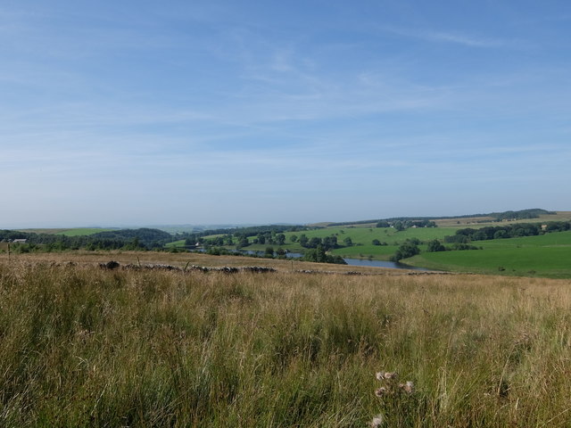
Horse Holme Wood is a picturesque woodland located in the county of Yorkshire, England. Spanning over an area of approximately 200 acres, this enchanting forest is nestled in the heart of the Holme Valley, offering a tranquil retreat for nature enthusiasts and outdoor adventurers alike.

The woodland is primarily composed of native tree species such as oak, beech, and birch, which create a diverse and vibrant ecosystem. These majestic trees provide a dense canopy, casting dappled sunlight on the forest floor below. The woodland is also home to a variety of flora, including bluebells, wild garlic, and ferns, which add to its natural beauty.

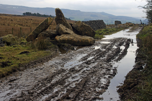
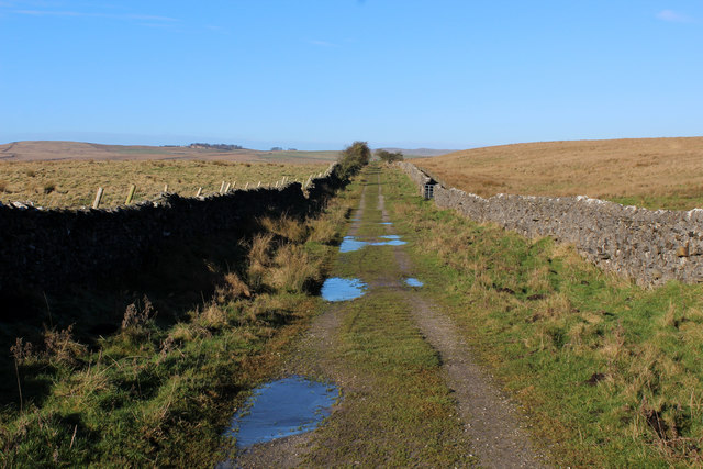
Horse Holme Wood is intersected by a network of well-maintained footpaths, allowing visitors to explore its hidden treasures. The paths wind through the woodland, leading to secluded clearings, babbling brooks, and stunning viewpoints overlooking the surrounding countryside. The wood is also intersected by the Holme River, which further enhances the area's charm.

The wood is renowned for its diverse wildlife, providing a habitat for numerous animal species. Visitors may be lucky enough to spot deer, foxes, badgers, and a variety of bird species, including woodpeckers and owls. The tranquil atmosphere of the wood makes it an ideal location for birdwatching and wildlife photography.

Horse Holme Wood is a popular destination for outdoor activities such as walking, cycling, and picnicking. Its natural beauty and peaceful ambiance make it a perfect escape from the hustle and bustle of everyday life. Whether it is a leisurely stroll through the forest or an adventure-filled exploration, Horse Holme Wood offers a captivating experience for visitors of all ages.

If you have any feedback on the listing, please let us know in the comments section below.

Horse Holme Wood Images

Images are sourced within 2km of 54.032091/-2.0913827 or Grid Reference SD9459. Thanks to Geograph Open Source API. All images are credited.

Hetton Moor, Moor Lane The benchmark is cut into a gatepost at a wall and footpath junction on the lane.
Hetton Moor, Moor Lane
The benchmark is cut into a gatepost at a wall and footpath junction on the lane.
Hetton Moor, Moor Lane There is a benchmark cut into a gatepost at the wall and footpath junction on the lane.
Hetton Moor, Moor Lane
There is a benchmark cut into a gatepost at the wall and footpath junction on the lane.
Gate at the end of Moor Lane Ramblers pause at a junction of footpaths above Winterburn reservoir.
Gate at the end of Moor Lane
Ramblers pause at a junction of footpaths above Winterburn reservoir.
Winterburn Reservoir from Moor Lane
Winterburn Reservoir
Hetton Common Beck
Hetton Common Beck
Path alongside Winterburn Reservoir
Moor Lane Some large stone blocks have been deposited beside the track, apparently to rebuild the dry stone walls.
Moor Lane
Some large stone blocks have been deposited beside the track, apparently to rebuild the dry stone walls.
Recycled stone, Moor Lane One of the stone blocks deposited beside the track, is clearly pre-loved.
Recycled stone, Moor Lane
One of the stone blocks deposited beside the track, is clearly pre-loved.
Remains of Carlisle Laithe
Bridleway in Alans Plantation
Bridge over Hetton Common Beck
Winterburn Reservoir A westward view over the Winterburn Reservoir, constructed to maintain water levels along the Leeds and Liverpool Canal
Winterburn Reservoir
A westward view over the Winterburn Reservoir, constructed to maintain water levels along the Leeds and Liverpool Canal
Bridleway above Winterburn Reservoir The bridleway crosses wet moorland towards Alans Plantation
Bridleway above Winterburn Reservoir
The bridleway crosses wet moorland towards Alans Plantation
Bridleway heading down to Hetton Common Beck The trouble with posting massive amounts of photographs on this site, is the sin of duplication. I have taken one from almost the same spot roughly 14 years ago.
<a href="https://www.geograph.org.uk/photo/286021">SD9460 : Moor Lane</a>
Bridleway heading down to Hetton Common Beck
The trouble with posting massive amounts of photographs on this site, is the sin of duplication. I have taken one from almost the same spot roughly 14 years ago. SD9460 : Moor Lane
Remnants of Carlisle Laithe Stone barn now reduced to a pile of rubble, or almost. At least it warrants a mention on the Ordnance Survey map.
Remnants of Carlisle Laithe
Stone barn now reduced to a pile of rubble, or almost. At least it warrants a mention on the Ordnance Survey map.
On Moor Lane Long straight green lane adopted by the Dales High Way long distance footpath
On Moor Lane
Long straight green lane adopted by the Dales High Way long distance footpath
Old Boundary Marker near Winterburn Reservoir Canal Company Boundary Marker at the northern end of Winterburn Reservoir south of the inflow of Whetstone Gill. Flasby with Winterburn parish. Inscribed L L C. Winterburn Reservoir feeds the Leeds and Liverpool Canal.

Milestone Society National ID: YW_FLAWIN01em
Old Boundary Marker near Winterburn Reservoir
Canal Company Boundary Marker at the northern end of Winterburn Reservoir south of the inflow of Whetstone Gill. Flasby with Winterburn parish. Inscribed L L C. Winterburn Reservoir feeds the Leeds and Liverpool Canal. Milestone Society National ID: YW_FLAWIN01em
Show me another place!

Horse Holme Wood is located at Grid Ref: SD9459 (Lat: 54.032091, Lng: -2.0913827)

Division: West Riding

Administrative County: North Yorkshire

District: Craven

Police Authority: North Yorkshire

What 3 Words

///slimming.spun.works. Near Gargrave, North Yorkshire

Nearby Locations

Horse Holme Wood

Related Wikis

Winterburn

Winterburn is a village in the Craven district of North Yorkshire, England. It is about 5 miles (8 km) south west of Grassington. Winterburn Reservoir...

Winterburn Reservoir

Winterburn Reservoir is located near the village of Winterburn in Malhamdale, North Yorkshire, England. It was constructed between 1885 and 1893 by Leeds...

Hetton, North Yorkshire

Hetton is a small Dales village in the civil parish of Hetton-cum-Bordley, in the North Yorkshire district of North Yorkshire, England, situated 5.75 miles...

Rylstone railway station

Rylstone railway station was a railway station that served the small village of Rylstone in North Yorkshire, England. It was built by the Yorkshire Dales...

Flasby

Flasby is a hamlet in the Yorkshire Dales in North Yorkshire, England. It is one of the two settlements, with Winterburn, in the civil parish of Flasby...

Rylstone

Rylstone is a village and civil parish in the Craven district of North Yorkshire, England. It is situated very near to Cracoe and about 6 miles south west...

St Peter's Church, Rylstone

St Peter's Church is in the village of Rylstone, North Yorkshire, England. It is an active Anglican parish church in the deanery of Skipton, the archdeaconry...

Cracoe

Cracoe is a small village and civil parish in the Craven district of North Yorkshire, England. It is situated near to Rylstone and about 6 miles south...

Nearby Amenities

Located within 500m of 54.032091,-2.0913827
Natural: peak
Source: OS 1:25k
Lat/Long: 54.0292097/-2.0907909
Barrier: cattle_grid
Source: GPS survey
Lat/Long: 54.0355537/-2.0882457
Barrier: cattle_grid
Source: GPS survey
Lat/Long: 54.0323244/-2.0929937
Hiking: yes
Information: guidepost
Source: GPS survey
Tourism: information
Lat/Long: 54.0307365/-2.0974392
lime kiln
Archaeological Site: lime_kiln
Historic: archaeological_site
Mineral: limestone
Output: lime
Source: OS sheet 150,publ 1853
Lat/Long: 54.0352196/-2.0866561
Power: pole
Source: Bing
Lat/Long: 54.0344399/-2.0851598
Power: pole
Source: Bing
Lat/Long: 54.034475/-2.0852324
Power: pole
Source: Bing
Lat/Long: 54.0350234/-2.0861092
Power: pole
Source: Bing
Lat/Long: 54.0356876/-2.0871441
Power: pole
Source: Bing
Lat/Long: 54.0287191/-2.0962851
Power: pole
Source: Bing
Lat/Long: 54.029484/-2.0958623
Power: pole
Source: Bing
Lat/Long: 54.0298725/-2.0948066
Power: pole
Source: Bing
Lat/Long: 54.0302442/-2.0938313
Power: pole
Source: Bing
Lat/Long: 54.0306876/-2.092651
Power: pole
Source: Bing
Lat/Long: 54.0310258/-2.0917224
Power: pole
Source: Bing
Lat/Long: 54.03146/-2.0905889
Power: pole
Source: Bing
Lat/Long: 54.031783/-2.0896992
Power: pole
Source: Bing
Lat/Long: 54.0320603/-2.0889962
Power: pole
Source: Bing
Lat/Long: 54.0325082/-2.087873
Power: pole
Source: Bing
Lat/Long: 54.0331176/-2.0869963
Power: pole
Source: Bing
Lat/Long: 54.0337681/-2.0860677
The data included in this document is from www.openstreetmap.org. The data is made available under ODbL.

Have you been to Horse Holme Wood?

Leave your review of Horse Holme Wood below (or comments, questions and feedback).