East Park

Wood, Forest in Durham

England

East Park

View from the road over fields of Boltshope Park These fields are amongst the last cultivated land before the road ascends onto Moorland
View from the road over fields of Boltshope Park Credit: Clive Nicholson

East Park is a picturesque woodland located in Durham, England. Situated on the eastern outskirts of the city, the park covers an extensive area and is known for its enchanting woodlands and beautiful forest scenery.

The park boasts a diverse range of tree species, including oak, beech, and birch, which create a dense canopy and provide a peaceful and tranquil atmosphere. Walking through the park, visitors can enjoy the calming sounds of birds chirping and leaves rustling underfoot.

In addition to its natural beauty, East Park offers a variety of recreational activities for visitors to enjoy. There are well-maintained walking trails that wind through the woods, providing ample opportunities for hiking and jogging. The park also features picnic areas, where families and friends can gather to enjoy a meal surrounded by nature.

For those interested in wildlife, East Park is home to a range of animals and birds. Squirrels can often be spotted darting through the trees, while birdwatchers may have the chance to see woodpeckers, thrushes, and other woodland species.

East Park is a popular destination for both locals and tourists alike, offering a peaceful escape from the bustling city. Its natural beauty, diverse wildlife, and recreational opportunities make it a beloved spot for nature enthusiasts and those seeking a tranquil retreat.

If you have any feedback on the listing, please let us know in the comments section below.

East Park Images

Images are sourced within 2km of 54.814134/-2.1109608 or Grid Reference NY9246. Thanks to Geograph Open Source API. All images are credited.

View from the road over fields of Boltshope Park These fields are amongst the last cultivated land before the road ascends onto Moorland
View from the road over fields of Boltshope Park
These fields are amongst the last cultivated land before the road ascends onto Moorland
Footpath to Cuthbert's Hill crossing the moor road
Road over Hunstanworth Moor
Sheep grazing at Boltshope Park
Sheep grazing at Boltshope Park Although clearly not in the same grid square, Bolt's Law hill and the chimneys from the old mine workings on the opposite side of the valley can be seen.
Sheep grazing at Boltshope Park
Although clearly not in the same grid square, Bolt's Law hill and the chimneys from the old mine workings on the opposite side of the valley can be seen.
Grouse butt on Hunstanworth Moor
Grouse butt on Hunstanworth Moor This peak of Bolt's Law is on the horizon
Grouse butt on Hunstanworth Moor
This peak of Bolt's Law is on the horizon
Road near St. Cuthberts Hill on Hunstanworth Moor
Road near Ramshawsike Plantation Looking southward.
Road near Ramshawsike Plantation
Looking southward.
Moorland Road crossing Hunstanworth Moor near White Hill Looking south-westward.
Moorland Road crossing Hunstanworth Moor near White Hill
Looking south-westward.
Moorland Road being crossed by a footpath on Hunstanworth Moor Looking south-westward.
Moorland Road being crossed by a footpath on Hunstanworth Moor
Looking south-westward.
Slope descending to Whitelees The near building is the farmhouse at Whitelees. The slope is descending into the valley of the Nookton Burn; Nookton (Farm) is to be seen on the opposite slope.
Slope descending to Whitelees
The near building is the farmhouse at Whitelees. The slope is descending into the valley of the Nookton Burn; Nookton (Farm) is to be seen on the opposite slope.
High camp, Stanhope Common Early morning mist fills Weardale.
High camp, Stanhope Common
Early morning mist fills Weardale.
Gate in fence line along path The path in the direction of view is heading towards Bolt's Law.
Gate in fence line along path
The path in the direction of view is heading towards Bolt's Law.
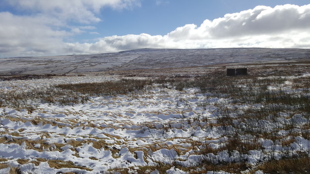
Frozen pool at meeting of bridleway and hill road The bridleway follows the darker heather line to the left with the hill road coming in from the right; both are perfectly clear on the ground here on the west side of Bolt's Law which is the shallow moorland hill occupying the skyline. Behind the camera position however, only the hill road is easy to follow; the bridleway all but loses its identity.
Frozen pool at meeting of bridleway and hill road
The bridleway follows the darker heather line to the left with the hill road coming in from the right; both are perfectly clear on the ground here on the west side of Bolt's Law which is the shallow moorland hill occupying the skyline. Behind the camera position however, only the hill road is easy to follow; the bridleway all but loses its identity.
Fence line towards Cuthbert's Hill Cuthbert's Hill is a tiny feature in the landscape, it's to be seen just breaking the skyline to the left of the red-clad walker.
Bolt's Law is the more distant hill.
Fence line towards Cuthbert's Hill
Cuthbert's Hill is a tiny feature in the landscape, it's to be seen just breaking the skyline to the left of the red-clad walker. Bolt's Law is the more distant hill.
Old Guide Stone on White Hill, Stanhope parish Stone post by the UC road, in parish of Stanhope (Wear Valley District), by track.

To be surveyed

Milestone Society National ID: DU_XROBA
Old Guide Stone on White Hill, Stanhope parish
Stone post by the UC road, in parish of Stanhope (Wear Valley District), by track. To be surveyed Milestone Society National ID: DU_XROBA
Hill road passing through gate The road is on ground above the valley of the Nookton Burn. The road is also the route of a public footpath which continues (off the road), to the deserted house at Gibraltar.
Hill road passing through gate
The road is on ground above the valley of the Nookton Burn. The road is also the route of a public footpath which continues (off the road), to the deserted house at Gibraltar.
Show me another place!

East Park is located at Grid Ref: NY9246 (Lat: 54.814134, Lng: -2.1109608)

Unitary Authority: County Durham

Police Authority: Durham

What 3 Words

///limits.shelters.coast. Near Stanhope, Co. Durham

Related Wikis

Ramshaw, Consett

Ramshaw is a small village in County Durham, in England. It is situated to the south of Hunstanworth, a few miles west of Consett. Lead mining was an important...

Townfield

Townfield is a village in County Durham, in England. It is situated just to the south of Hunstanworth and part of that parish, about 10 miles (16 km) west...

Beldon Burn

Beldon Burn is a headwater stream of the River Derwent in Northumberland and County Durham, England.It rises at Quickcleugh Moss as the Quickcleugh Burn...

Hunstanworth

Hunstanworth is a village in County Durham, England. It is situated approximately 10 miles to the west of Consett, south-west of the village of Blanchland...

Lintzgarth

Lintzgarth is a village in the civil parish of Stanhope, in County Durham, England. It is situated to the west of Rookhope. The Lintzgarth smeltmill was...

Baybridge, Northumberland

Baybridge is a small village in Northumberland, England, just to the west of Blanchland and on the border with County Durham. It is situated to the west...

Blanchland

Blanchland is a village in Northumberland, England, on the County Durham boundary. The population of the civil parish at the 2011 census was 135.Set beside...

Blanchland Abbey

Blanchland Abbey at Blanchland, in the English county of Northumberland, was founded as a premonstratensian priory in 1165 by Walter de Bolbec II, and...

Nearby Amenities

Located within 500m of 54.814134,-2.1109608
Man Made: sheepfold
Wikimedia Commons: File:Sheepfold above Whitelees (2) - geograph.org.uk - 720235.jpg
Lat/Long: 54.8142812/-2.1175101
The data included in this document is from www.openstreetmap.org. The data is made available under ODbL.

Have you been to East Park?

Leave your review of East Park below (or comments, questions and feedback).