Beeswing Fox Covert
Wood, Forest in Northumberland
England
Beeswing Fox Covert

Beeswing Fox Covert is a picturesque woodland area located in the county of Northumberland, in the northeast of England. Covering an area of approximately 200 acres, it is one of the most popular woodlands in the region and is known for its natural beauty and diverse wildlife.
The woodland is predominantly made up of mature oak and beech trees, providing a dense canopy that creates a tranquil and secluded atmosphere. As visitors explore the numerous winding paths, they will come across a variety of native flora, including bluebells, wild garlic, and ferns, which add to the enchanting ambiance of the woodland.
Beeswing Fox Covert is renowned for its rich biodiversity, attracting nature enthusiasts and bird watchers from all over. The woodland is home to a wide range of wildlife, including foxes, badgers, and roe deer, which can often be spotted during early mornings or at dusk. Bird species such as woodpeckers, owls, and various songbirds can also be heard and seen among the treetops.
The woodland provides an ideal habitat for many species due to its diverse landscape, which includes a small pond and a meandering stream. These water features attract a variety of aquatic creatures, including frogs, newts, and dragonflies, further enhancing the ecological value of Beeswing Fox Covert.
Overall, Beeswing Fox Covert offers visitors a peaceful retreat in the heart of Northumberland. Its natural beauty, diverse flora and fauna, and tranquil atmosphere make it a must-visit destination for nature lovers and those seeking a peaceful escape in the great outdoors.
If you have any feedback on the listing, please let us know in the comments section below.
Beeswing Fox Covert Images
Images are sourced within 2km of 55.699363/-2.1262686 or Grid Reference NT9245. Thanks to Geograph Open Source API. All images are credited.


Beeswing Fox Covert is located at Grid Ref: NT9245 (Lat: 55.699363, Lng: -2.1262686)
Unitary Authority: Northumberland
Police Authority: Northumbria
What 3 Words
///mole.stadium.mealtime. Near Ancroft, Northumberland
Nearby Locations
Related Wikis

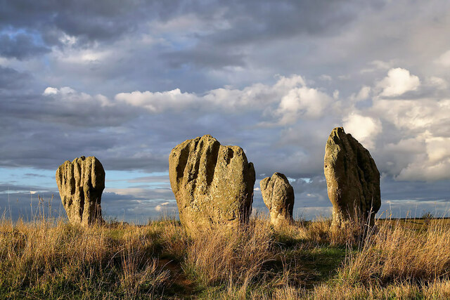
Duddo Five Stones
Duddo Five Stones (grid reference NT930437) is a stone circle north of Duddo in North Northumberland, approximately 4miles (6 km) South of the Scottish...

Shoreswood
Shoreswood is a place and civil parish about 6 miles from Berwick-upon-Tweed, in the county of Northumberland, England. The parish includes the hamlets...

Norham railway station
Norham railway station served the village of Norham, Northumberland, England, from 1849 to 1965 on the Kelso Branch. == History == The station opened on...
Norham
Norham ( NORR-əm) is a village and civil parish in Northumberland, England. It is 7 miles (11 km) south-west of Berwick on the south side of the River...
Nearby Amenities
Located within 500m of 55.699363,-2.1262686Have you been to Beeswing Fox Covert?
Leave your review of Beeswing Fox Covert below (or comments, questions and feedback).