Grave Plantation

Wood, Forest in Northumberland

England

Grave Plantation

Pretty waterfall on the Holywell Burn
Pretty waterfall on the Holywell Burn Credit: Leanmeanmo

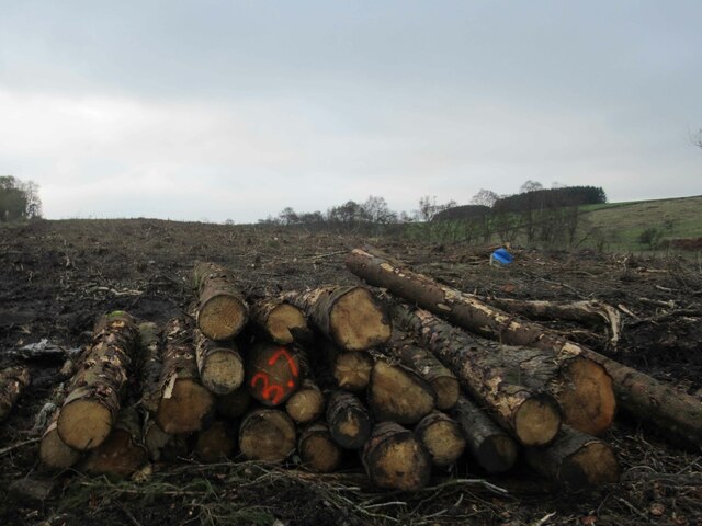
Grave Plantation is a woodland area located in Northumberland, England. Situated in the heart of the county, it spans across a vast expanse of approximately 200 acres, offering a serene and picturesque environment for nature enthusiasts and wildlife lovers alike.

The plantation is predominantly made up of dense woodlands, characterized by a variety of towering trees such as oak, beech, and ash, creating a dense canopy that provides shelter and nesting opportunities for numerous bird species. The forest floor is adorned with a vibrant carpet of ferns, mosses, and wildflowers, adding to the enchanting beauty of the area.

Traversing through Grave Plantation, visitors can explore a network of well-maintained trails, allowing them to immerse themselves in the natural wonders of the woodland. The paths wind through the trees, revealing breathtaking views of the surrounding countryside and offering glimpses of elusive wildlife, including deer, foxes, and an array of bird species.

The plantation also boasts a diverse ecosystem, with a small stream meandering through its heart, providing a water source for the resident flora and fauna. This water feature attracts a variety of aquatic life, including frogs, newts, and dragonflies.

Grave Plantation is not only a haven for wildlife but also serves as a recreational area for locals and tourists alike. The well-equipped picnic areas and benches scattered throughout the woodland provide an ideal setting for relaxation and enjoying the tranquility of nature.

Overall, Grave Plantation in Northumberland is a treasure trove of natural beauty, offering a peaceful escape from the hustle and bustle of everyday life. Its diverse ecosystem and well-maintained trails make it an ideal destination for nature lovers, hikers, and families seeking to reconnect with the great outdoors.

If you have any feedback on the listing, please let us know in the comments section below.

Grave Plantation Images

Images are sourced within 2km of 55.095511/-2.1660667 or Grid Reference NY8977. Thanks to Geograph Open Source API. All images are credited.

Pretty waterfall on the Holywell Burn
Pretty waterfall on the Holywell Burn Metres from the road, completely hidden from view.
Pretty waterfall on the Holywell Burn
Metres from the road, completely hidden from view.
Former Percy Arms Pub Another rural pub bites the dust.
Former Percy Arms Pub
Another rural pub bites the dust.
Plantation near T-Junction
View Across Farmland
Covered Reservoir and Communication Mast
Trig Point Robbingstob Hill
Pond on Robbingstob Hill
Felled Trees, Cola Burn Plantation
Felled Trees, Coal Burn Plantation
Plantation near Coal Burn
Trig point at Batey Catreen The unusually named trig point, Batey Catreen stands beside a little used minor road which connects the A68 with the small village of Birtley and the larger one, Wark. The surrounding area is moorland but unaccountably not classified as open access ground under the CROW act of the year 2000.
Trig point at Batey Catreen
The unusually named trig point, Batey Catreen stands beside a little used minor road which connects the A68 with the small village of Birtley and the larger one, Wark. The surrounding area is moorland but unaccountably not classified as open access ground under the CROW act of the year 2000.
Minor road heading north The road is heading almost exactly north towards the farm at Pittland Hills as seen from a road junction north-east of the small village of Birtley.
Minor road heading north
The road is heading almost exactly north towards the farm at Pittland Hills as seen from a road junction north-east of the small village of Birtley.
Community centre beyond football pitch The community centre and pitch are in the village of Birtley - a small settlement, not to be confused with the much larger town of the same name which is now part of Gateshead.
Community centre beyond football pitch
The community centre and pitch are in the village of Birtley - a small settlement, not to be confused with the much larger town of the same name which is now part of Gateshead.
Small barn beside road entering Birtley Birtley is a small settlement, not to be confused with the much larger town of the same name which is now part of Gateshead.
The road in the foreground enters the village from the south. There are two road signs in the image; the more obvious one names the village, the other is a much older, cast iron sign directing travellers to the nearby village of Wark and to Wark Station.
Small barn beside road entering Birtley
Birtley is a small settlement, not to be confused with the much larger town of the same name which is now part of Gateshead. The road in the foreground enters the village from the south. There are two road signs in the image; the more obvious one names the village, the other is a much older, cast iron sign directing travellers to the nearby village of Wark and to Wark Station.
Bales on Threpwood Hill Threpwood Hill is a minor feature in the landscape, a rise to something over 150 metres. It lies to the south of the Northumbrian village of Birtley and in the image is viewed from the west..
Bales on Threpwood Hill
Threpwood Hill is a minor feature in the landscape, a rise to something over 150 metres. It lies to the south of the Northumbrian village of Birtley and in the image is viewed from the west..
Road over Rubbingstob Hill Looking westward from Batey Catreen Triangulation Pillar.
Road over Rubbingstob Hill
Looking westward from Batey Catreen Triangulation Pillar.
St Giles' Church, Birtley 'Parish church. C12 restored 1884. Dressed stone and random rubble. Welsh
slate roof. Nave, chancel, west porch and south-west tower. Chancel north
wall and nave masonry is C12.' 
<span class="nowrap"><a title="https://britishlistedbuildings.co.uk/101370467-church-of-st-giles-birtley#.XOax1IhKiUk" rel="nofollow ugc noopener" href="https://britishlistedbuildings.co.uk/101370467-church-of-st-giles-birtley#.XOax1IhKiUk">Link</a><img style="margin-left:2px;" alt="External link" title="External link - shift click to open in new window" src="https://s1.geograph.org.uk/img/external.png" width="10" height="10"/></span>
St Giles' Church, Birtley
'Parish church. C12 restored 1884. Dressed stone and random rubble. Welsh slate roof. Nave, chancel, west porch and south-west tower. Chancel north wall and nave masonry is C12.' LinkExternal link
Show me another place!

Grave Plantation is located at Grid Ref: NY8977 (Lat: 55.095511, Lng: -2.1660667)

Unitary Authority: Northumberland

Police Authority: Northumbria

What 3 Words

///heads.jungle.scooters. Near Birtley, Northumberland

Related Wikis

Birtley, Northumberland

Birtley is a village in Northumberland, England southeast of Bellingham. It is about 10 miles (16 km) north of Hexham. == References == == External... ==
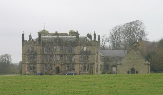
Chipchase Castle

Chipchase Castle is a 17th-century Jacobean mansion incorporating a substantial 14th-century pele tower, which stands north of Hadrian's Wall, near Wark...

Wark railway station

Wark railway station is a disused railway station which served the village of Wark on Tyne, Northumberland, England. Located on the Border Counties Railway...

Wark on Tyne

Wark on Tyne is a small village and civil parish in Northumberland, England, 12 miles (19 km) north of Hexham. == History == The name is derived from the...

Nearby Amenities

Located within 500m of 55.095511,-2.1660667
The data included in this document is from www.openstreetmap.org. The data is made available under ODbL.

Have you been to Grave Plantation?

Leave your review of Grave Plantation below (or comments, questions and feedback).