Long Mead Wood

Wood, Forest in Wiltshire

England

Long Mead Wood

Clanger Wood, Wiltshire Looking southwest from the main track in Clanger Wood towards the carpark on the Westbury Road (A350).
Clanger Wood, Wiltshire Credit: Rebecca A Wills

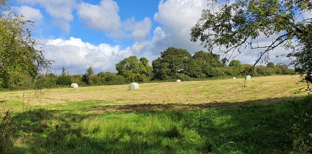
Long Mead Wood is a picturesque woodland located in the county of Wiltshire, England. Covering an area of approximately 300 acres, it is situated just north of the village of Lacock. The wood is primarily made up of native broadleaf trees such as oak, beech, and ash, creating a diverse and vibrant ecosystem.

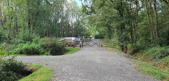
The wood is known for its tranquil atmosphere and enchanting beauty. It offers a plethora of walking trails, allowing visitors to explore and immerse themselves in the natural surroundings. These paths wind their way through the ancient trees, leading to hidden clearings and secluded spots where one can relax and enjoy the peacefulness of the woodland.

Long Mead Wood is home to a rich variety of flora and fauna. Bluebells carpet the forest floor during spring, creating a breathtaking sight. The wood is also abundant in wildlife, with numerous species of birds, mammals, and insects calling it their home. Visitors may be lucky enough to spot deer, badgers, foxes, and a wide array of bird species while exploring the wood.

Managed by the National Trust, Long Mead Wood is a protected area, ensuring the preservation of its natural beauty and biodiversity. The wood is open to the public throughout the year, with visitors being able to enjoy the changing seasons and the different colors and scents that come with them. Whether it is for a peaceful walk, wildlife observation, or simply to appreciate the wonders of nature, Long Mead Wood is a true gem in the heart of Wiltshire.

If you have any feedback on the listing, please let us know in the comments section below.

Long Mead Wood Images

Images are sourced within 2km of 51.286526/-2.1626151 or Grid Reference ST8854. Thanks to Geograph Open Source API. All images are credited.

Clanger Wood, Wiltshire Looking southwest from the main track in Clanger Wood towards the carpark on the Westbury Road (A350).
Clanger Wood, Wiltshire
Looking southwest from the main track in Clanger Wood towards the carpark on the Westbury Road (A350).
Clanger Wood, Wiltshire Farmland adjacent to the western perimeter of Clanger Wood.
Clanger Wood, Wiltshire
Farmland adjacent to the western perimeter of Clanger Wood.
Church Road, Heywood The church is on the left in the distance. I believe it is now redundant or possibly a private house.
Church Road, Heywood
The church is on the left in the distance. I believe it is now redundant or possibly a private house.
Monkey Puzzle Tree, Church Lane, Heywood Commonly known as a Monkey Puzzle tree, it is a slow growing evergreen tree growing up to 40 m tall with a 2 m trunk diameter. It is native to central and southern Chile and western Argentina. It is the hardiest species of the conifer genus Araucaria.
The tree usually has male and female cones on separate trees and is a wind pollinated. The seeds are usually dispersed by birds and squirrels. They are edible, similar to large pinenuts. However the tree does not yield seeds until it is around 30 to 40 years old. It is tolerant of temperatures down to -20°C, and coastal salt spray.
It was originally found in Chile in the 1780s and is the national tree of Chile.
Monkey Puzzle Tree, Church Lane, Heywood
Commonly known as a Monkey Puzzle tree, it is a slow growing evergreen tree growing up to 40 m tall with a 2 m trunk diameter. It is native to central and southern Chile and western Argentina. It is the hardiest species of the conifer genus Araucaria. The tree usually has male and female cones on separate trees and is a wind pollinated. The seeds are usually dispersed by birds and squirrels. They are edible, similar to large pinenuts. However the tree does not yield seeds until it is around 30 to 40 years old. It is tolerant of temperatures down to -20°C, and coastal salt spray. It was originally found in Chile in the 1780s and is the national tree of Chile.
Westbury Cement Works View from near the White Horse
Westbury Cement Works
View from near the White Horse
Old Milestone by the A350, Westbury Road, Yarnbrook Metal plate attached to stone post by the A350, in parish of North Bradley (West Wiltshire District), Westbury Road, Yarnbrook, in front of service road near No. 46 on verge, on East side of road. Westbury plate, erected by the Westbury turnpike trust in the 19th century.

Inscription reads:-
99
LONDON
{line}
TROWBRIDGE 3
{arrow}
WESTBURY 2
{arrow}

Milestone Society National ID: WI_WYMK02
Old Milestone by the A350, Westbury Road, Yarnbrook
Metal plate attached to stone post by the A350, in parish of North Bradley (West Wiltshire District), Westbury Road, Yarnbrook, in front of service road near No. 46 on verge, on East side of road. Westbury plate, erected by the Westbury turnpike trust in the 19th century. Inscription reads:- 99 LONDON {line} TROWBRIDGE 3 {arrow} WESTBURY 2 {arrow} Milestone Society National ID: WI_WYMK02
Cresswell Down Farm, Bratton Road
New stable off Capps Lane
2008 : Fields near Oakstone Farm Stopping for a break near Oakstone Farm we catch sight of the Lafarge Cement Works chimney at Westbury. <a href="https://www.geograph.org.uk/gridref/ST8852">ST8852</a>
2008 : Fields near Oakstone Farm
Stopping for a break near Oakstone Farm we catch sight of the Lafarge Cement Works chimney at Westbury. ST8852
2008 : Cresswell Down Farm Seen from Bratton Road.
Mentioned on the website <span class="nowrap"><a title="http://www.mylocalservices.co.uk/Wiltshire/Mixed_Crops/182667/J_W_Rogers.html" rel="nofollow ugc noopener" href="http://www.mylocalservices.co.uk/Wiltshire/Mixed_Crops/182667/J_W_Rogers.html">Link</a><img style="margin-left:2px;" alt="External link" title="External link - shift click to open in new window" src="https://s1.geograph.org.uk/img/external.png" width="10" height="10"/></span>
The hillside in the distance is near Devizes.
2008 : Cresswell Down Farm
Seen from Bratton Road. Mentioned on the website LinkExternal link The hillside in the distance is near Devizes.
2010 : Capps Lane looking east Starts at the A350, as Park Lane, runs east, becomes Capps Lane and ends at Trowbridge Road north of Bratton. Some pleasant but unspectacular views north and south on the way.
2010 : Capps Lane looking east
Starts at the A350, as Park Lane, runs east, becomes Capps Lane and ends at Trowbridge Road north of Bratton. Some pleasant but unspectacular views north and south on the way.
2010 : Capps Lane looking east Looking toward Trowbridge Road and Bratton.
The hill in front is part of the northern escarpment of Salisbury Plain above Edington.
2010 : Capps Lane looking east
Looking toward Trowbridge Road and Bratton. The hill in front is part of the northern escarpment of Salisbury Plain above Edington.
2010 : Looking east on Bratton Road Near Cresswell Down Farm.
Bratton Road takes the traveller from West Ashton through Dunge and on to Bratton via Trowbridge Road.
The hill crossing the background is the northern escarpment of Salisbury Plain above Edington.
2010 : Looking east on Bratton Road
Near Cresswell Down Farm. Bratton Road takes the traveller from West Ashton through Dunge and on to Bratton via Trowbridge Road. The hill crossing the background is the northern escarpment of Salisbury Plain above Edington.
2010 : West on Bratton Road Dunge is about 1km in front then West Ashton in about 3km.
2010 : West on Bratton Road
Dunge is about 1km in front then West Ashton in about 3km.
2010 : North from Capps Lane Believe this is Oakstone Farm but am uncertain.
2010 : North from Capps Lane
Believe this is Oakstone Farm but am uncertain.
St John The Evangelist, West Ashton Church at West Ashton
St John The Evangelist, West Ashton
Church at West Ashton
Westbury cement plant Operated 1962 to 2009, this was the last wet process plant to operate in the British Isles.  For the pedants, the stack's millimetre grid reference is ST8899964452717892 from OS digital mapping, and thus, of its 32 ft diameter base, 54.6% is within square ST8852.  Viewed from White Horse Hill, just east of the plant's chalk quarry.

In addition to the chalk, which was pumped as a slurry to the plant, clay was used as 20% of the raw material mix.  Initially, Cretaceous Gault Clay was used, obtained from its outcrop just this side of the railway.  Subsequently, Jurassic Kimmeridge Clay was obtained from the fields beyond the plant, and partially flooded workings remain.  For more details, see <span class="nowrap"><a title="http://www.cementkilns.co.uk/cement_kiln_westbury.html" rel="nofollow ugc noopener" href="http://www.cementkilns.co.uk/cement_kiln_westbury.html">Link</a><img style="margin-left:2px;" alt="External link" title="External link - shift click to open in new window" src="https://s1.geograph.org.uk/img/external.png" width="10" height="10"/></span>.
Westbury cement plant
Operated 1962 to 2009, this was the last wet process plant to operate in the British Isles. For the pedants, the stack's millimetre grid reference is ST8899964452717892 from OS digital mapping, and thus, of its 32 ft diameter base, 54.6% is within square ST8852. Viewed from White Horse Hill, just east of the plant's chalk quarry. In addition to the chalk, which was pumped as a slurry to the plant, clay was used as 20% of the raw material mix. Initially, Cretaceous Gault Clay was used, obtained from its outcrop just this side of the railway. Subsequently, Jurassic Kimmeridge Clay was obtained from the fields beyond the plant, and partially flooded workings remain. For more details, see LinkExternal link.
Pastures at Horse Croft Farm The railway to the east of Westbury travels through flat countryside.  Here, looking north, we see the fields of Horse Croft Farm.  The farm buildings are actually in <a href="https://www.geograph.org.uk/gridref/ST8953">ST8953</a>.  It is so named because it is opposite the Westbury white horse, carved in the hill behind us.
This photo was taken from the 1158 Penzance to London Paddington train, having left Castle Cary at 1550.
Pastures at Horse Croft Farm
The railway to the east of Westbury travels through flat countryside. Here, looking north, we see the fields of Horse Croft Farm. The farm buildings are actually in ST8953. It is so named because it is opposite the Westbury white horse, carved in the hill behind us. This photo was taken from the 1158 Penzance to London Paddington train, having left Castle Cary at 1550.
Show me another place!

Long Mead Wood is located at Grid Ref: ST8854 (Lat: 51.286526, Lng: -2.1626151)

Unitary Authority: Wiltshire

Police Authority: Wiltshire

What 3 Words

///raven.spice.medium. Near North Bradley, Wiltshire

Nearby Locations

Long Mead Wood

Related Wikis

Picket and Clanger Wood

Picket and Clanger Wood (grid reference ST875543) is a 66.4 hectare biological Site of Special Scientific Interest in Wiltshire, England, and lies off...

Heywood, Wiltshire

Heywood is a civil parish and small village in the county of Wiltshire in southwestern England. The village is approximately 1.5 miles (2.4 km) north of...

West Ashton

West Ashton is a village and civil parish in Wiltshire, England. It is about 2 miles (3.2 km) southeast of Trowbridge, near the A350 between Melksham and...

Rood Ashton House

Rood Ashton House was a country house in Wiltshire, England, standing in parkland 0.5 miles (0.80 km) northeast of the village of West Ashton, near Trowbridge...

Yarnbrook

Yarnbrook is a large hamlet in Wiltshire, England, between the towns of Westbury and Trowbridge. Most of the settlement lies in the civil parish of North...

Westbury White Horse

Westbury or Bratton White Horse is a hill figure on the escarpment of Salisbury Plain, approximately 1.5 mi (2.4 km) east of Westbury in Wiltshire, England...

Bratton Castle

Bratton Castle (also known as Bratton Camp) is a bivallate (two ramparts) Iron Age built hill fort on Bratton Down, at the western edge of the Salisbury...

Battle of Edington

At the Battle of Edington, an army of the kingdom of Wessex under Alfred the Great defeated the Great Heathen Army led by the Dane Guthrum on a date between...

Have you been to Long Mead Wood?

Leave your review of Long Mead Wood below (or comments, questions and feedback).