Bradney Wood

Wood, Forest in Staffordshire South Staffordshire

England

Bradney Wood

Council Housing - Pennwood Court One of three tower blocks built in 1967 on high ground at Merry Hill.
Council Housing - Pennwood Court Credit: John M

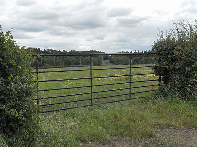
Bradney Wood is a picturesque woodland area located in Staffordshire, England. Covering approximately 100 acres, this forest is known for its diverse range of flora and fauna, making it a popular destination for nature enthusiasts and hikers.

The woodland is primarily comprised of broadleaf trees, such as oak, beech, and birch, creating a dense and vibrant canopy overhead. These trees provide a haven for various bird species, including woodpeckers, owls, and songbirds, which can often be heard chirping and singing throughout the day.

In addition to the abundant birdlife, Bradney Wood is also home to numerous mammal species, such as deer, foxes, and rabbits, which can occasionally be spotted while exploring the forest trails. The wood is particularly known for its healthy population of badgers, which have made their homes in the underground setts scattered throughout the area.

Several walking paths wind their way through the wood, offering visitors the opportunity to immerse themselves in the natural beauty of the surroundings. These trails range in difficulty, catering to both casual walkers and more experienced hikers. Along the paths, visitors can admire the vibrant wildflowers that carpet the forest floor during the spring and summer months.

Bradney Wood is not only a haven for wildlife but also serves as an important conservation area, with efforts in place to maintain and enhance its natural habitat. The woodland is managed by the local authorities, who work tirelessly to preserve this tranquil and biodiverse environment for future generations to enjoy.

If you have any feedback on the listing, please let us know in the comments section below.

Bradney Wood Images

Images are sourced within 2km of 52.55382/-2.1684764 or Grid Reference SO8895. Thanks to Geograph Open Source API. All images are credited.

Council Housing - Pennwood Court One of three tower blocks built in 1967 on high ground at Merry Hill.
Council Housing - Pennwood Court
One of three tower blocks built in 1967 on high ground at Merry Hill.
Council Housing - St Joseph's Court One of three tower blocks built in 1967 on high ground at Merry Hill.
Council Housing - St Joseph's Court
One of three tower blocks built in 1967 on high ground at Merry Hill.
Council Housing - Warstones Gardens Stylistically these appear to be 1950s though are not shown on my late 1960s streetmap.
Council Housing - Warstones Gardens
Stylistically these appear to be 1950s though are not shown on my late 1960s streetmap.
Council Housing - Warstones Drive Stylistically these appear to be 1950s though are not shown on my late 1960s streetmap.
Council Housing - Warstones Drive
Stylistically these appear to be 1950s though are not shown on my late 1960s streetmap.
Council Housing - North Green The early 1950s saw the postwar development at Warstones. Like other estates of the period there were no boundary walls on the frontage. The photo is taken from the Warstones Green open space.
Council Housing - North Green
The early 1950s saw the postwar development at Warstones. Like other estates of the period there were no boundary walls on the frontage. The photo is taken from the Warstones Green open space.
Council Housing - East Green The early 1950s saw the postwar development at Warstones. Like other estates of the period there were no boundary walls on the frontage. The photo is taken from the Warstones Green open space.
Council Housing - East Green
The early 1950s saw the postwar development at Warstones. Like other estates of the period there were no boundary walls on the frontage. The photo is taken from the Warstones Green open space.
Council Housing - Kingslow Avenue The council housing programme of the 1950s was driven by slum clearance of the areas close to the town centre.

Despite some misgivings with regard to the social effects Wolverhampton Council adopted the policy of building flats. The first blocks of flats were built on the Newbolds Estate in 1950 followed by more blocks at Merridale in 1954. The largest collection occurs on the Long Knowle Estate built in 1955-6. The Graiseley Estate (Dale Street)saw the first deck access flats built in the borough with two eight storey blocks, since demolished. 

The early 1950s saw a change in housing policy with overspill estates developed by Wolverhampton Council outside the borough boundaries in Wednesfield UDC (Long Knowle and Ashmore Park) and Seisdon RDC (Wombourne).
  
Further developments continued within the borough boundaries at Deans Road (next to Old Heath Estate), Underhill (next to The Scotlands Estate)and Warstones.
Council Housing - Kingslow Avenue
The council housing programme of the 1950s was driven by slum clearance of the areas close to the town centre. Despite some misgivings with regard to the social effects Wolverhampton Council adopted the policy of building flats. The first blocks of flats were built on the Newbolds Estate in 1950 followed by more blocks at Merridale in 1954. The largest collection occurs on the Long Knowle Estate built in 1955-6. The Graiseley Estate (Dale Street)saw the first deck access flats built in the borough with two eight storey blocks, since demolished. The early 1950s saw a change in housing policy with overspill estates developed by Wolverhampton Council outside the borough boundaries in Wednesfield UDC (Long Knowle and Ashmore Park) and Seisdon RDC (Wombourne). Further developments continued within the borough boundaries at Deans Road (next to Old Heath Estate), Underhill (next to The Scotlands Estate)and Warstones.
Council Housing - Claverley Drive The immediate post war period saw some inovative designs using preformed components such as these houses on the Warstones Estate.
Council Housing - Claverley Drive
The immediate post war period saw some inovative designs using preformed components such as these houses on the Warstones Estate.
Council Housing - Pinfold Grove Low rise housing built in the shadow of the three high rise blocks at Merry Hill. This housing is similar to types in the new towns with pedestrian access to the front of the properties.
Council Housing - Pinfold Grove
Low rise housing built in the shadow of the three high rise blocks at Merry Hill. This housing is similar to types in the new towns with pedestrian access to the front of the properties.
Warstones Health Centre Health centre in Pinfold Grove.
Warstones Health Centre
Health centre in Pinfold Grove.
Merryhill Brook at Warstones The brook appears to start on the west flank of Goldthorn Hill flowing towards the flats at Merry Hill where it enters a culvert. Emerging on the city boundary it falls to meet the Smestow Brook and onwards to join the River Severn.
Merryhill Brook at Warstones
The brook appears to start on the west flank of Goldthorn Hill flowing towards the flats at Merry Hill where it enters a culvert. Emerging on the city boundary it falls to meet the Smestow Brook and onwards to join the River Severn.
Council Housing - Kingsclere Walk These houses date from around 1970.
Council Housing - Kingsclere Walk
These houses date from around 1970.
Manor Road in Penn, Wolverhampton The austere looking house on the right is The Hollies. Muchall Park is behind the mature trees on the left. The single track lane links the A449 Penn Road with Mount Road by Penn Cricket Club.
Manor Road in Penn, Wolverhampton
The austere looking house on the right is The Hollies. Muchall Park is behind the mature trees on the left. The single track lane links the A449 Penn Road with Mount Road by Penn Cricket Club.
The green at Penn Bowling Club, Wolverhampton Penn Bowling and Social Club is a well run club for local people. In addition to the bowling, activities include darts, dominoes, poker, bingo, crib, pool, salsa dancing and (of course) large screen TV to watch football. Oh, nearly forgot! It has a bar too, which serves Banks's Bitter and Mild, plus three guest real ales - all superbly kept.

update August 2018 - There is a defibrillator stationed here by the main entrance to the club.

<a href="https://www.geograph.org.uk/photo/2733190">SO8995 : The Penn Bowling Club  handpumps, Wolverhampton</a> 

I think they sell lager, too. ;-)
The green at Penn Bowling Club, Wolverhampton
Penn Bowling and Social Club is a well run club for local people. In addition to the bowling, activities include darts, dominoes, poker, bingo, crib, pool, salsa dancing and (of course) large screen TV to watch football. Oh, nearly forgot! It has a bar too, which serves Banks's Bitter and Mild, plus three guest real ales - all superbly kept. update August 2018 - There is a defibrillator stationed here by the main entrance to the club. SO8995 : The Penn Bowling Club handpumps, Wolverhampton I think they sell lager, too. ;-)
Penn Bowling Club, Wolverhampton The image shows part of the green and club buildings, with the mature deciduous trees of Muchall Park as the backdrop.

Penn Bowling and Social Club is a well run club for local people. In addition to the bowling, regular activities include darts, dominoes, poker, crib, pool, bingo, salsa dancing and (of course) large screen TV to watch football. Oh, nearly forgot! It has a good bar too, which serves Banks's Bitter and Mild, plus three hand-pulled guest real ales - all superbly kept. People occasionally drink lager, I'm told. ;-)

update August 2018 - There is a defibrillator stationed here by the main entrance to the club.
Penn Bowling Club, Wolverhampton
The image shows part of the green and club buildings, with the mature deciduous trees of Muchall Park as the backdrop. Penn Bowling and Social Club is a well run club for local people. In addition to the bowling, regular activities include darts, dominoes, poker, crib, pool, bingo, salsa dancing and (of course) large screen TV to watch football. Oh, nearly forgot! It has a good bar too, which serves Banks's Bitter and Mild, plus three hand-pulled guest real ales - all superbly kept. People occasionally drink lager, I'm told. ;-) update August 2018 - There is a defibrillator stationed here by the main entrance to the club.
Gated field adjacent the A449
A449 Dual Carriageway, Penn Where the Tesco store is over the road, the site used to be a Petrol Station until a few years ago.
A449 Dual Carriageway, Penn
Where the Tesco store is over the road, the site used to be a Petrol Station until a few years ago.
A449 Dual Carriageway, Stourbridge Road Lloyd House Barns are on the left, the barns have been converted to housing.
A449 Dual Carriageway, Stourbridge Road
Lloyd House Barns are on the left, the barns have been converted to housing.
Show me another place!

Bradney Wood is located at Grid Ref: SO8895 (Lat: 52.55382, Lng: -2.1684764)

Administrative County: Staffordshire

District: South Staffordshire

Police Authority: Staffordshire

What 3 Words

///lined.jets.dent. Near Wombourn, Staffordshire

Nearby Locations

Bradney Wood

Related Wikis

Lower Penn

Lower Penn is a village in South Staffordshire, situated to the south-west of Wolverhampton, West Midlands. The Civil Parish covers the area of the historic...

St Bartholomew's Church, Penn

St Bartholomew's Church is in Penn, a district of Wolverhampton, West Midlands, England. It is an active Anglican parish church in the deanery of Trysull...

Penn, West Midlands

Penn is an area which is divided between the City of Wolverhampton and South Staffordshire district. The population of the Wolverhampton Ward taken at...

Highfields School, Wolverhampton

Highfields School is a mixed secondary school and sixth form located in the Penn area of Wolverhampton, in the West Midlands of England. It was formed...

Nearby Amenities

Located within 500m of 52.55382,-2.1684764
Mini Roundabout
Direction: clockwise
Lat/Long: 52.5563653/-2.1730358
Traffic Signals
Source: bing
Lat/Long: 52.5576954/-2.1647497
Mini Roundabout
Direction: clockwise
Lat/Long: 52.5564624/-2.1728498
Post Box
Lat/Long: 52.5562354/-2.1701715
Bus Stop
Warstones Rd / Spring Hill Lane
NaPTANAreaCode: 43000738401
Bench: yes
Bus: yes
Naptan AtcoCode: 43000738401
Naptan Bearing: NE
Naptan BusStopType: MKD
Naptan CommonName: Spring Hill Lane
Naptan Indicator: after
Naptan NaptanCode: nwmjmamw
Naptan PlusbusZoneRef: BHAMNWS
Naptan Status: ACT
Naptan StopType: BCT
Naptan Street: WARSTONES RD
Naptan Towards: Wolverhampton
Naptan Verified: no
Public Transport: platform
Route Ref: 4
Shelter: yes
Shelter Ref: 104001
Source: WMCA
Lat/Long: 52.5566137/-2.1728718
Bus Stop
Warstones Rd / Spring Hill Lane
Bus: yes
Naptan AtcoCode: 43000738402
Naptan Bearing: S
Naptan BusStopType: MKD
Naptan CommonName: Spring Hill Lane
Naptan Indicator: before
Naptan NaptanCode: nwmjmapa
Naptan PlusbusZoneRef: BHAMNWS
Naptan Status: ACT
Naptan StopType: BCT
Naptan Street: WARSTONES RD
Naptan Towards: Penn
Naptan Verified: no
Public Transport: platform
Route Ref: 4
Source: WMCA
Lat/Long: 52.556767/-2.1725184
Bus Stop
Penn Rd / The Hollybush
Bus: yes
Naptan AtcoCode: 43000732801
Naptan Bearing: SW
Naptan BusStopType: MKD
Naptan CommonName: The Hollybush
Naptan Indicator: opp
Naptan NaptanCode: nwmjgtwm
Naptan PlusbusZoneRef: BHAMNWS
Naptan Status: ACT
Naptan StopType: BCT
Naptan Street: PENN RD
Naptan Towards: Wombourne
Naptan Verified: no
Public Transport: platform
Route Ref: 255;256
Source: WMCA
Lat/Long: 52.557471/-2.1654497
Bus Stop
Penn Rd / The Hollybush
NaPTANAreaCode: 43000732802
Bus: yes
Naptan AtcoCode: 43000732802
Naptan Bearing: NE
Naptan BusStopType: MKD
Naptan CommonName: The Hollybush
Naptan Indicator: adj
Naptan NaptanCode: nwmjgtwp
Naptan PlusbusZoneRef: BHAMNWS
Naptan Status: ACT
Naptan StopType: BCT
Naptan Street: PENN RD
Naptan Towards: Wolverhampton
Naptan Verified: no
Public Transport: platform
Route Ref: 255;256
Shelter: yes
Shelter Ref: 104003
Source: WMCA
Lat/Long: 52.5576941/-2.1655909
Bus Stop
Penn Rd / Springhill Lane
Bus: yes
Naptan AtcoCode: 43000732901
Naptan Bearing: SW
Naptan BusStopType: MKD
Naptan CommonName: Springhill Lane
Naptan Indicator: opp
Naptan NaptanCode: nwmjgtwt
Naptan PlusbusZoneRef: BHAMNWS
Naptan Status: ACT
Naptan StopType: BCT
Naptan Street: PENN RD
Naptan Towards: Wombourne
Naptan Verified: no
Public Transport: platform
Route Ref: 255;256
Source: WMCA
Lat/Long: 52.5563113/-2.1690326
Bus Stop
Penn Rd / Springhill Lane
NaPTANAreaCode: 43000732902
Bus: yes
Naptan AtcoCode: 43000732902
Naptan Bearing: NE
Naptan BusStopType: MKD
Naptan CommonName: Springhill Lane
Naptan Indicator: adj
Naptan NaptanCode: nwmjgwad
Naptan PlusbusZoneRef: BHAMNWS
Naptan Status: ACT
Naptan StopType: BCT
Naptan Street: PENN RD
Naptan Towards: Wolverhampton
Public Transport: platform
Route Ref: 255;256
Shelter: yes
Shelter Ref: 104002
Source: WMCA
Lat/Long: 52.5563127/-2.169564
Power: tower
Lat/Long: 52.5540266/-2.1679859
Power: tower
Lat/Long: 52.551712/-2.1638909
Power: tower
Source: bing
Lat/Long: 52.5515271/-2.1675305
Power: tower
Source: bing
Lat/Long: 52.5514661/-2.1641069
Turning Circle
Source: bing
Lat/Long: 52.5543621/-2.1676428
Power: tower
Source: bing
Lat/Long: 52.5514909/-2.1702816
Turning Circle
Lat/Long: 52.5558262/-2.1673516
Co-Operative Food
Shop: convenience
Lat/Long: 52.5559199/-2.1705907
Kenchez
Designation: Kenchez
Shop: hairdresser
Lat/Long: 52.5562729/-2.1702197
Shop: car_repair
Lat/Long: 52.5559844/-2.1708461
Fast Food
Chinese Take Away
Cuisine: chinese
Lat/Long: 52.5563177/-2.170017
Fast Food
Fish & Chips
Cuisine: fish_and_chips
Lat/Long: 52.55629/-2.1701592
Man Made: tower
Lat/Long: 52.5561082/-2.1700588
Power: tower
Source: bing
Lat/Long: 52.5557143/-2.1694045
Turning Circle
Lat/Long: 52.5514093/-2.1726043
Barrier: stile
Lat/Long: 52.5503895/-2.1680043
Traffic Signals
Source: bing
Lat/Long: 52.5577837/-2.1651542
Generator Method: photovoltaic
Generator Output Electricity: yes
Generator Source: solar
Generator Type: solar_photovoltaic_panel
Location: roof
Power: generator
Lat/Long: 52.555773/-2.1690568
Generator Method: photovoltaic
Generator Output Electricity: yes
Generator Source: solar
Generator Type: solar_photovoltaic_panel
Location: roof
Power: generator
Lat/Long: 52.554638/-2.1707413
Generator Method: photovoltaic
Generator Output Electricity: yes
Generator Source: solar
Generator Type: solar_photovoltaic_panel
Location: roof
Power: generator
Lat/Long: 52.5561921/-2.1740323
Generator Method: photovoltaic
Generator Output Electricity: yes
Generator Source: solar
Generator Type: solar_photovoltaic_panel
Location: roof
Power: generator
Lat/Long: 52.5547179/-2.1738124
The data included in this document is from www.openstreetmap.org. The data is made available under ODbL.

Have you been to Bradney Wood?

Leave your review of Bradney Wood below (or comments, questions and feedback).