Long Coppice
Wood, Forest in Dorset
England
Long Coppice
Long Coppice is a picturesque woodland located in Dorset, England. Situated near the village of Sixpenny Handley, it covers an area of approximately 65 hectares. The wood is predominantly made up of mature broadleaf trees, including oak, beech, and ash, with some areas of coniferous trees such as Scots pine.
The wood has a rich history dating back several centuries. It has been managed sustainably for many years to produce timber for various purposes, including fencing, construction, and furniture making. The traditional management practices have ensured the long-term health and biodiversity of the woodland.
Long Coppice offers a tranquil escape for nature lovers and outdoor enthusiasts. There are several well-maintained walking trails that wind through the wood, providing opportunities to observe a variety of flora and fauna. Bluebells carpet the forest floor in spring, creating a stunning display of vibrant colors.
The wood is also home to a diverse range of wildlife. Visitors may spot deer, badgers, foxes, and a plethora of bird species, including woodpeckers, owls, and various songbirds. The peaceful atmosphere and natural beauty of Long Coppice make it an ideal habitat for these creatures.
In addition to its natural wonders, Long Coppice provides educational and recreational opportunities for visitors. The wood hosts workshops and educational events to promote sustainable woodland management and conservation. There are also designated areas for picnicking and camping, allowing visitors to immerse themselves fully in the woodland experience.
Overall, Long Coppice is a remarkable woodland that offers a delightful escape into nature, combining historical significance, biodiversity, and recreational activities.
If you have any feedback on the listing, please let us know in the comments section below.
Long Coppice Images
Images are sourced within 2km of 50.678771/-2.1943711 or Grid Reference SY8686. Thanks to Geograph Open Source API. All images are credited.
![Wool Bridge [1] A bridge over the River Frome is recorded at this point in 1343, but the current Wool Bridge is probably 16th century. Repairs are documented in 1607, 1688, 1742 and 1806. An additional flood arch, was built in, probably, the late 19th century. During the Second World War, the bridge was widened and the parapets removed to allow tanks from nearby Bovingdon Camp to cross. The parapets were later rebuilt using the same stone. The bridge is now only passable to horse riders, cyclists and pedestrians. Listed, grade II*, with details at: <span class="nowrap"><a title="https://historicengland.org.uk/listing/the-list/list-entry/1171233" rel="nofollow ugc noopener" href="https://historicengland.org.uk/listing/the-list/list-entry/1171233">Link</a><img style="margin-left:2px;" alt="External link" title="External link - shift click to open in new window" src="https://s1.geograph.org.uk/img/external.png" width="10" height="10"/></span>](https://s2.geograph.org.uk/geophotos/07/25/69/7256914_3248aeb1.jpg)
![Wool Bridge [2] A bridge over the River Frome is recorded at this point in 1343, but the current Wool Bridge is probably 16th century. Repairs are documented in 1607, 1688, 1742 and 1806. An additional flood arch, was built in, probably, the late 19th century. During the Second World War, the bridge was widened and the parapets removed to allow tanks from nearby Bovingdon Camp to cross. The parapets were later rebuilt using the same stone. The bridge is now only passable to horse riders, cyclists and pedestrians. Listed, grade II*, with details at: <span class="nowrap"><a title="https://historicengland.org.uk/listing/the-list/list-entry/1171233" rel="nofollow ugc noopener" href="https://historicengland.org.uk/listing/the-list/list-entry/1171233">Link</a><img style="margin-left:2px;" alt="External link" title="External link - shift click to open in new window" src="https://s1.geograph.org.uk/img/external.png" width="10" height="10"/></span>](https://s3.geograph.org.uk/geophotos/07/25/69/7256915_21104063.jpg)
![Wool Bridge [3] A plaque on the bridge.
A bridge over the River Frome is recorded at this point in 1343, but the current Wool Bridge is probably 16th century. Repairs are documented in 1607, 1688, 1742 and 1806. An additional flood arch, was built in, probably, the late 19th century. During the Second World War, the bridge was widened and the parapets removed to allow tanks from nearby Bovingdon Camp to cross. The parapets were later rebuilt using the same stone. The bridge is now only passable to horse riders, cyclists and pedestrians. Listed, grade II*, with details at: <span class="nowrap"><a title="https://historicengland.org.uk/listing/the-list/list-entry/1171233" rel="nofollow ugc noopener" href="https://historicengland.org.uk/listing/the-list/list-entry/1171233">Link</a><img style="margin-left:2px;" alt="External link" title="External link - shift click to open in new window" src="https://s1.geograph.org.uk/img/external.png" width="10" height="10"/></span>](https://s0.geograph.org.uk/geophotos/07/25/69/7256916_97178f70.jpg)
![Wool Bridge [4] The River Frome, looking downstream from the bridge.
A bridge over the River Frome is recorded at this point in 1343, but the current Wool Bridge is probably 16th century. Repairs are documented in 1607, 1688, 1742 and 1806. An additional flood arch, was built in, probably, the late 19th century. During the Second World War, the bridge was widened and the parapets removed to allow tanks from nearby Bovingdon Camp to cross. The parapets were later rebuilt using the same stone. The bridge is now only passable to horse riders, cyclists and pedestrians. Listed, grade II*, with details at: <span class="nowrap"><a title="https://historicengland.org.uk/listing/the-list/list-entry/1171233" rel="nofollow ugc noopener" href="https://historicengland.org.uk/listing/the-list/list-entry/1171233">Link</a><img style="margin-left:2px;" alt="External link" title="External link - shift click to open in new window" src="https://s1.geograph.org.uk/img/external.png" width="10" height="10"/></span>](https://s1.geograph.org.uk/geophotos/07/25/69/7256917_60452eb9.jpg)
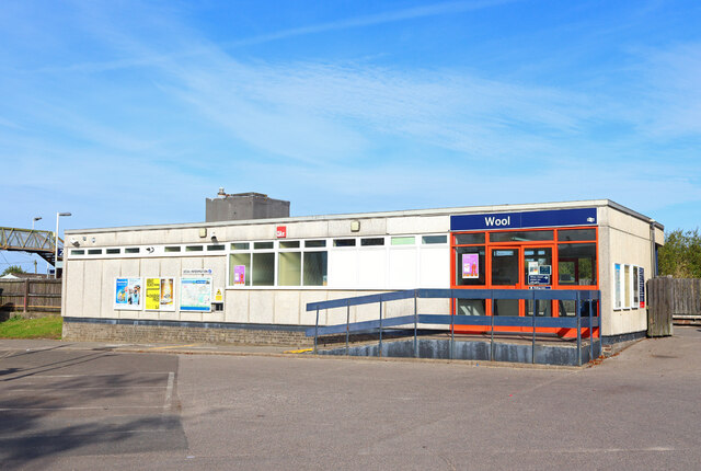
![Wool features [1] Wool railway station is on the South Western main line. The station was opened in 1847 by the Southampton and Dorchester Railway. Here the 13:45 service to London, Waterloo is taking on passengers.
Wool is a large village in Dorset, midway between Dorchester and Poole, both about 10 miles distant. Set on the south bank of the River Frome, the village includes Bovington Camp army base to the north. The place-name &#039;Wool&#039; is first recorded in Anglo-Saxon Writs in the first years of the 11th century. The ruins of Bindon Abbey are nearby, demolished in 1539, the stone was used to build castles in Portland, Lulworth and Sandsfoot.](https://s0.geograph.org.uk/geophotos/07/25/80/7258064_de3d5884.jpg)
![Wool features [2] Wool railway station is on the South Western main line. The station was opened in 1847 by the Southampton and Dorchester Railway. Here the 13:45 service to London, Waterloo has just departed.
Wool is a large village in Dorset, midway between Dorchester and Poole, both about 10 miles distant. Set on the south bank of the River Frome, the village includes Bovington Camp army base to the north. The place-name &#039;Wool&#039; is first recorded in Anglo-Saxon Writs in the first years of the 11th century. The ruins of Bindon Abbey are nearby, demolished in 1539, the stone was used to build castles in Portland, Lulworth and Sandsfoot.](https://s1.geograph.org.uk/geophotos/07/25/80/7258065_7a71a763.jpg)
![Wool houses [1] Cowslip Cottage, Station Road, was probably built in the 18th century. Constructed of stuccoed rubble stone under a thatch roof. There is a later rear extension. At one time the cottage and the adjoining weatherboarded building operated as tearooms and later as a restaurant. Listed, grade II, with details at: <span class="nowrap"><a title="https://historicengland.org.uk/listing/the-list/list-entry/1120336" rel="nofollow ugc noopener" href="https://historicengland.org.uk/listing/the-list/list-entry/1120336">Link</a><img style="margin-left:2px;" alt="External link" title="External link - shift click to open in new window" src="https://s1.geograph.org.uk/img/external.png" width="10" height="10"/></span>
Wool is a large village in Dorset, midway between Dorchester and Poole, both about 10 miles distant. Set on the south bank of the River Frome, the village includes Bovington Camp army base to the north. The place-name &#039;Wool&#039; is first recorded in Anglo-Saxon Writs in the first years of the 11th century. The ruins of Bindon Abbey are nearby, demolished in 1539, the stone was used to build castles in Portland, Lulworth and Sandsfoot.](https://s3.geograph.org.uk/geophotos/07/25/80/7258067_4a8180ea.jpg)
![Wool Buildings [2] Wool Methodist church, Station Road, was built in 1893. Constructed of red brick with ashlar dressings under a slate roof.
Wool is a large village in Dorset, midway between Dorchester and Poole, both about 10 miles distant. Set on the south bank of the River Frome, the village includes Bovington Camp army base to the north. The place-name &#039;Wool&#039; is first recorded in Anglo-Saxon Writs in the first years of the 11th century. The ruins of Bindon Abbey are nearby, demolished in 1539, the stone was used to build castles in Portland, Lulworth and Sandsfoot.](https://s0.geograph.org.uk/geophotos/07/25/80/7258068_4922fff6.jpg)
![Wool features [4] The village pound in Bindon Lane. The square enclosure of brick was probably built in the 19th century. Listed, grade II, with details at: <span class="nowrap"><a title="https://historicengland.org.uk/listing/the-list/list-entry/1120398" rel="nofollow ugc noopener" href="https://historicengland.org.uk/listing/the-list/list-entry/1120398">Link</a><img style="margin-left:2px;" alt="External link" title="External link - shift click to open in new window" src="https://s1.geograph.org.uk/img/external.png" width="10" height="10"/></span>
Wool is a large village in Dorset, midway between Dorchester and Poole, both about 10 miles distant. Set on the south bank of the River Frome, the village includes Bovington Camp army base to the north. The place-name &#039;Wool&#039; is first recorded in Anglo-Saxon Writs in the first years of the 11th century. The ruins of Bindon Abbey are nearby, demolished in 1539, the stone was used to build castles in Portland, Lulworth and Sandsfoot.](https://s1.geograph.org.uk/geophotos/07/25/80/7258069_4400a5f0.jpg)
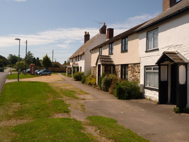
![Wool houses [2] Springfield Cottage, High Street, was originally two cottages. Possibly built in the late 17th century and altered in the late 18th century and in the 19th century. Constructed of plastered rubble stone under a thatch roof. A former stable attached to the house has is of similar construction. Listed, grade II, with details at: <span class="nowrap"><a title="https://historicengland.org.uk/listing/the-list/list-entry/1120370" rel="nofollow ugc noopener" href="https://historicengland.org.uk/listing/the-list/list-entry/1120370">Link</a><img style="margin-left:2px;" alt="External link" title="External link - shift click to open in new window" src="https://s1.geograph.org.uk/img/external.png" width="10" height="10"/></span>
Wool is a large village in Dorset, midway between Dorchester and Poole, both about 10 miles distant. Set on the south bank of the River Frome, the village includes Bovington Camp army base to the north. The place-name &#039;Wool&#039; is first recorded in Anglo-Saxon Writs in the first years of the 11th century. The ruins of Bindon Abbey are nearby, demolished in 1539, the stone was used to build castles in Portland, Lulworth and Sandsfoot.](https://s3.geograph.org.uk/geophotos/07/25/80/7258071_d9520149.jpg)
![Wool houses [3] Tumbledown Cottage, number 8 High Street, was probably built in the 18th century. Constructed of plastered rubble stone under a thatch roof. There is a large outbuilding at the rear. Listed, grade II, with details at: <span class="nowrap"><a title="https://historicengland.org.uk/listing/the-list/list-entry/1152923" rel="nofollow ugc noopener" href="https://historicengland.org.uk/listing/the-list/list-entry/1152923">Link</a><img style="margin-left:2px;" alt="External link" title="External link - shift click to open in new window" src="https://s1.geograph.org.uk/img/external.png" width="10" height="10"/></span>
Wool is a large village in Dorset, midway between Dorchester and Poole, both about 10 miles distant. Set on the south bank of the River Frome, the village includes Bovington Camp army base to the north. The place-name &#039;Wool&#039; is first recorded in Anglo-Saxon Writs in the first years of the 11th century. The ruins of Bindon Abbey are nearby, demolished in 1539, the stone was used to build castles in Portland, Lulworth and Sandsfoot.](https://s0.geograph.org.uk/geophotos/07/25/80/7258072_4e8c84e6.jpg)
![Wool houses [4] Jumpers Cottage, number 9 High Street, was formerly two cottages. Probably built in the 18th century. Constructed of plastered rubble stone under a thatch roof. The windows are all horizontally sliding sash windows. A former outbuilding at the rear is now incorporated into the cottage. Listed, grade II, with details at: <span class="nowrap"><a title="https://historicengland.org.uk/listing/the-list/list-entry/1120371" rel="nofollow ugc noopener" href="https://historicengland.org.uk/listing/the-list/list-entry/1120371">Link</a><img style="margin-left:2px;" alt="External link" title="External link - shift click to open in new window" src="https://s1.geograph.org.uk/img/external.png" width="10" height="10"/></span>
Wool is a large village in Dorset, midway between Dorchester and Poole, both about 10 miles distant. Set on the south bank of the River Frome, the village includes Bovington Camp army base to the north. The place-name &#039;Wool&#039; is first recorded in Anglo-Saxon Writs in the first years of the 11th century. The ruins of Bindon Abbey are nearby, demolished in 1539, the stone was used to build castles in Portland, Lulworth and Sandsfoot.](https://s1.geograph.org.uk/geophotos/07/25/80/7258073_04afad14.jpg)
![Wool houses [5] This pair of cottages, numbers 16 and 17 High Street, were built in the late 18th or early 19th century. Constructed of rubble stone with brick dressings under a tile roof. The windows are horizontally sliding sash. Listed, for group value, grade II, with details at: <span class="nowrap"><a title="https://historicengland.org.uk/listing/the-list/list-entry/1152925" rel="nofollow ugc noopener" href="https://historicengland.org.uk/listing/the-list/list-entry/1152925">Link</a><img style="margin-left:2px;" alt="External link" title="External link - shift click to open in new window" src="https://s1.geograph.org.uk/img/external.png" width="10" height="10"/></span>
Wool is a large village in Dorset, midway between Dorchester and Poole, both about 10 miles distant. Set on the south bank of the River Frome, the village includes Bovington Camp army base to the north. The place-name &#039;Wool&#039; is first recorded in Anglo-Saxon Writs in the first years of the 11th century. The ruins of Bindon Abbey are nearby, demolished in 1539, the stone was used to build castles in Portland, Lulworth and Sandsfoot.](https://s2.geograph.org.uk/geophotos/07/25/80/7258074_8a3c549a.jpg)
![Wool houses [6] Burvan House, number 24 High Street (nearer the camera) and April Cottage, number 23 High Street were originally one house and later a house and shop. Number 23 was built in the 18th century, number 24 was built, probably, in the early 19th century. Number 23 is constructed of painted brick, Number 24 of plastered rubble stone, both under a thatch roof. Listed, grade II, with details at: <span class="nowrap"><a title="https://historicengland.org.uk/listing/the-list/list-entry/1120372" rel="nofollow ugc noopener" href="https://historicengland.org.uk/listing/the-list/list-entry/1120372">Link</a><img style="margin-left:2px;" alt="External link" title="External link - shift click to open in new window" src="https://s1.geograph.org.uk/img/external.png" width="10" height="10"/></span>
Wool is a large village in Dorset, midway between Dorchester and Poole, both about 10 miles distant. Set on the south bank of the River Frome, the village includes Bovington Camp army base to the north. The place-name &#039;Wool&#039; is first recorded in Anglo-Saxon Writs in the first years of the 11th century. The ruins of Bindon Abbey are nearby, demolished in 1539, the stone was used to build castles in Portland, Lulworth and Sandsfoot.](https://s2.geograph.org.uk/geophotos/07/25/80/7258082_3df8bb43.jpg)
![Wool features [5] In High Street is this K6 telephone box, designed in 1935 by Sir Giles Gilbert Scott. Listed, grade II, with details at: <span class="nowrap"><a title="https://historicengland.org.uk/listing/the-list/list-entry/1454418" rel="nofollow ugc noopener" href="https://historicengland.org.uk/listing/the-list/list-entry/1454418">Link</a><img style="margin-left:2px;" alt="External link" title="External link - shift click to open in new window" src="https://s1.geograph.org.uk/img/external.png" width="10" height="10"/></span>
Wool is a large village in Dorset, midway between Dorchester and Poole, both about 10 miles distant. Set on the south bank of the River Frome, the village includes Bovington Camp army base to the north. The place-name &#039;Wool&#039; is first recorded in Anglo-Saxon Writs in the first years of the 11th century. The ruins of Bindon Abbey are nearby, demolished in 1539, the stone was used to build castles in Portland, Lulworth and Sandsfoot.](https://s2.geograph.org.uk/geophotos/07/25/80/7258086_5b91a884.jpg)
![Wool houses [7] Colliers Barn, High Street, has been converted into two houses. Probably originally built in the 18th century. Constructed partly of brick, partly of plastered rubble stone, all under a tile roof. Listed, grade II, with details at: <span class="nowrap"><a title="https://historicengland.org.uk/listing/the-list/list-entry/1152927" rel="nofollow ugc noopener" href="https://historicengland.org.uk/listing/the-list/list-entry/1152927">Link</a><img style="margin-left:2px;" alt="External link" title="External link - shift click to open in new window" src="https://s1.geograph.org.uk/img/external.png" width="10" height="10"/></span>
Wool is a large village in Dorset, midway between Dorchester and Poole, both about 10 miles distant. Set on the south bank of the River Frome, the village includes Bovington Camp army base to the north. The place-name &#039;Wool&#039; is first recorded in Anglo-Saxon Writs in the first years of the 11th century. The ruins of Bindon Abbey are nearby, demolished in 1539, the stone was used to build castles in Portland, Lulworth and Sandsfoot.](https://s0.geograph.org.uk/geophotos/07/25/80/7258092_f357b803.jpg)
![Wool houses [8] Part of a terrace, peppercorn Cottage, number 44 Spring Street, was probably built in the 18th century. Constructed of brick under a thatch roof. There is a modern rear wing. There are three horizontally sliding sash windows. Some original internal features remain. Listed, grade II, with details at: <span class="nowrap"><a title="https://historicengland.org.uk/listing/the-list/list-entry/1152946" rel="nofollow ugc noopener" href="https://historicengland.org.uk/listing/the-list/list-entry/1152946">Link</a><img style="margin-left:2px;" alt="External link" title="External link - shift click to open in new window" src="https://s1.geograph.org.uk/img/external.png" width="10" height="10"/></span>
Wool is a large village in Dorset, midway between Dorchester and Poole, both about 10 miles distant. Set on the south bank of the River Frome, the village includes Bovington Camp army base to the north. The place-name &#039;Wool&#039; is first recorded in Anglo-Saxon Writs in the first years of the 11th century. The ruins of Bindon Abbey are nearby, demolished in 1539, the stone was used to build castles in Portland, Lulworth and Sandsfoot.](https://s1.geograph.org.uk/geophotos/07/25/81/7258101_6a538cef.jpg)
Long Coppice is located at Grid Ref: SY8686 (Lat: 50.678771, Lng: -2.1943711)
Unitary Authority: Dorset
Police Authority: Dorset
What 3 Words
///unto.arrived.firewall. Near Wool, Dorset
Nearby Locations
Related Wikis

East Stoke, Dorset
East Stoke is a village in the English county of Dorset. It lies three miles west of the small town of Wareham and two miles east of Wool. In 2013 the...
Wool, Dorset
Wool is a large village, civil parish and electoral ward in south Dorset, England. In the 2011 census the parish – which includes Bovington Camp army base...

Bindon Abbey
Bindon Abbey (Bindonium) was a Cistercian monastery, of which only ruins remain, on the River Frome about half a mile east of Wool in the Purbeck District...

Wool railway station
Wool railway station serves the village of Wool in Dorset, England. It is on the South West Main Line, 125 miles 69 chains (202.6 km) down the line from...

Woolbridge Manor House
Woolbridge Manor is a 17th-century manor house just outside the village of Wool, in Dorset, England. English Heritage have designated it a Grade II* listed...

Monkey World
The Monkey World Ape Rescue Centre is a 65-acre (26.3 ha) ape and monkey sanctuary and rescue centre near Wool, Dorset, England. == History == Set up in...

Coombe Keynes
Coombe Keynes is a hamlet, civil parish and depopulated village in the Purbeck district of Dorset, England. The village is about 2 miles (3 km) south of...
Worgret Heath
Worgret Heath SSSI, Dorset (grid reference SY895871) is an 8.4 hectare biological Site of Special Scientific Interest in Dorset, notified in 1987.The site...
Nearby Amenities
Located within 500m of 50.678771,-2.1943711Have you been to Long Coppice?
Leave your review of Long Coppice below (or comments, questions and feedback).