Rathill Plantation

Wood, Forest in Wiltshire

England

Rathill Plantation

Entrance to Grittleton House Grittleton House is now a wedding and events venue, and has been lived in by the same family since 1967 <span class="nowrap"><a title="https://www.grittletonhouse.co.uk/us/" rel="nofollow ugc noopener" href="https://www.grittletonhouse.co.uk/us/">Link</a><img style="margin-left:2px;" alt="External link" title="External link - shift click to open in new window" src="https://s1.geograph.org.uk/img/external.png" width="10" height="10"/></span> . The building also housed a school until 2016 <span class="nowrap"><a title="https://www.gazetteandherald.co.uk/news/14532821.chippenhams-grittleton-house-school-to-close-in-the-summer/" rel="nofollow ugc noopener" href="https://www.gazetteandherald.co.uk/news/14532821.chippenhams-grittleton-house-school-to-close-in-the-summer/">Link</a><img style="margin-left:2px;" alt="External link" title="External link - shift click to open in new window" src="https://s1.geograph.org.uk/img/external.png" width="10" height="10"/></span> . It was a small independent privately-run day school of a kind that was now becoming rather rare.

The gatehouse can be seen here beside the main entrance.
Entrance to Grittleton House Credit: HelenK

Rathill Plantation, located in Wiltshire, is a picturesque wood or forest that covers an area of approximately 300 acres. It is situated near the village of Netheravon, offering a tranquil and serene escape from the nearby bustling towns. The plantation is easily accessible, with convenient road links and ample parking facilities.

The wood itself is a diverse mix of deciduous and coniferous trees, providing a rich and varied habitat for a wide range of flora and fauna. Visitors can expect to see species such as oak, beech, birch, and pine, as well as an array of wildflowers and ferns carpeting the forest floor during the spring and summer months.

Rathill Plantation offers several well-maintained footpaths and trails, allowing visitors to explore the woodland at their own pace. The paths are suitable for both walkers and cyclists, with designated routes clearly signposted. Nature enthusiasts will also appreciate the various bird hides strategically placed throughout the woodland, providing excellent viewing opportunities for birdwatching enthusiasts.

Additionally, the woodland is home to a diverse range of wildlife, including deer, foxes, badgers, and a plethora of bird species. Nature lovers will delight in the chance to spot these animals in their natural habitat.

Overall, Rathill Plantation is a delightful destination for those seeking a peaceful and scenic woodland experience. Whether for a leisurely stroll, a family picnic, or a nature-focused adventure, this Wiltshire woodland offers a fantastic opportunity to connect with nature and enjoy the beauty of the natural world.

If you have any feedback on the listing, please let us know in the comments section below.

Rathill Plantation Images

Images are sourced within 2km of 51.505659/-2.2040832 or Grid Reference ST8578. Thanks to Geograph Open Source API. All images are credited.

Entrance to Grittleton House Grittleton House is now a wedding and events venue, and has been lived in by the same family since 1967 <span class="nowrap"><a title="https://www.grittletonhouse.co.uk/us/" rel="nofollow ugc noopener" href="https://www.grittletonhouse.co.uk/us/">Link</a><img style="margin-left:2px;" alt="External link" title="External link - shift click to open in new window" src="https://s1.geograph.org.uk/img/external.png" width="10" height="10"/></span> . The building also housed a school until 2016 <span class="nowrap"><a title="https://www.gazetteandherald.co.uk/news/14532821.chippenhams-grittleton-house-school-to-close-in-the-summer/" rel="nofollow ugc noopener" href="https://www.gazetteandherald.co.uk/news/14532821.chippenhams-grittleton-house-school-to-close-in-the-summer/">Link</a><img style="margin-left:2px;" alt="External link" title="External link - shift click to open in new window" src="https://s1.geograph.org.uk/img/external.png" width="10" height="10"/></span> . It was a small independent privately-run day school of a kind that was now becoming rather rare.

The gatehouse can be seen here beside the main entrance.
Entrance to Grittleton House
Grittleton House is now a wedding and events venue, and has been lived in by the same family since 1967 LinkExternal link . The building also housed a school until 2016 LinkExternal link . It was a small independent privately-run day school of a kind that was now becoming rather rare. The gatehouse can be seen here beside the main entrance.
Fenced pavement, The Street, Grittleton This section of fenced-off pavement runs opposite the parish church and alongside the wall of Grittleton House <span class="nowrap"><a title="https://www.grittletonhouse.co.uk/" rel="nofollow ugc noopener" href="https://www.grittletonhouse.co.uk/">Link</a><img style="margin-left:2px;" alt="External link" title="External link - shift click to open in new window" src="https://s1.geograph.org.uk/img/external.png" width="10" height="10"/></span> , which can just be glimpsed through the trees.
Fenced pavement, The Street, Grittleton
This section of fenced-off pavement runs opposite the parish church and alongside the wall of Grittleton House LinkExternal link , which can just be glimpsed through the trees.
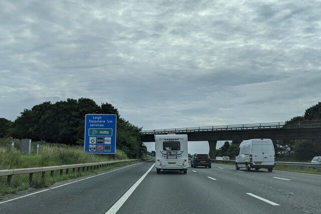
Lane crossing the M4, approaching Leigh Delamere services
Footpath near Kent's Bottom Farm
Autumn trees Autumn trees on Summer Lane near Upper Castle Combe.
Autumn trees
Autumn trees on Summer Lane near Upper Castle Combe.
Public right of way Public byway near Upper Castle Combe.
Public right of way
Public byway near Upper Castle Combe.
Road junction in Upper Castle Combe The B4039 passing through Upper Castle Combe.
Road junction in Upper Castle Combe
The B4039 passing through Upper Castle Combe.
Sunken bridleway Walking sunken paths and bridleways like this it feels timeless with nothing visible linking it to the 21st century.  This bridleway connects Upper Castle Combe with Castle Combe.
Sunken bridleway
Walking sunken paths and bridleways like this it feels timeless with nothing visible linking it to the 21st century. This bridleway connects Upper Castle Combe with Castle Combe.
Alderton Road, Grittleton Alderton Road is the only road in this square.  The village of Grittleton does not appear to have anything that would qualify as 'affordable housing', probably because of its easy access to junction 17 of the M4.  The homes in which farm labourers would once have lived must either have been demolished or have been knocked together to make larger houses, giving it a slightly unreal, model-village feel.
Alderton Road, Grittleton
Alderton Road is the only road in this square. The village of Grittleton does not appear to have anything that would qualify as 'affordable housing', probably because of its easy access to junction 17 of the M4. The homes in which farm labourers would once have lived must either have been demolished or have been knocked together to make larger houses, giving it a slightly unreal, model-village feel.
An historic moment for Grittleton Cricket Club Grittleton Cricket Club <span class="nowrap"><a title="https://www.grittletoncricketclub.org.uk/" rel="nofollow ugc noopener" href="https://www.grittletoncricketclub.org.uk/">Link</a><img style="margin-left:2px;" alt="External link" title="External link - shift click to open in new window" src="https://s1.geograph.org.uk/img/external.png" width="10" height="10"/></span> are seen playing Broughton Gifford Cricket Club.  At this point a Broughton Gifford bowler is two-thirds of the way through a hat trick <span class="nowrap"><a title="https://twitter.com/GrittletonCC/status/1417574091083681798" rel="nofollow ugc noopener" href="https://twitter.com/GrittletonCC/status/1417574091083681798">Link</a><img style="margin-left:2px;" alt="External link" title="External link - shift click to open in new window" src="https://s1.geograph.org.uk/img/external.png" width="10" height="10"/></span> , believed to be the first to be achieved by a woman in a match involving Grittleton CC, which has been in existence for at least 153 years.

In the background can be seen Grittleton Village Hall <span class="nowrap"><a title="https://sites.google.com/site/grittletonvillage/village-hall" rel="nofollow ugc noopener" href="https://sites.google.com/site/grittletonvillage/village-hall">Link</a><img style="margin-left:2px;" alt="External link" title="External link - shift click to open in new window" src="https://s1.geograph.org.uk/img/external.png" width="10" height="10"/></span> .
An historic moment for Grittleton Cricket Club
Grittleton Cricket Club LinkExternal link are seen playing Broughton Gifford Cricket Club. At this point a Broughton Gifford bowler is two-thirds of the way through a hat trick LinkExternal link , believed to be the first to be achieved by a woman in a match involving Grittleton CC, which has been in existence for at least 153 years. In the background can be seen Grittleton Village Hall LinkExternal link .
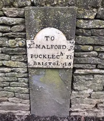
Old Milestone by The Street, Grittleton Metal plate attached to stone post by the UC road, in parish of GRITTLETON (NORTH WILTSHIRE District), The Street; Grittleton; opposite Grittleton House School by "Masons", partially inset into wall, on North side of road. Erected by the Christian Malford to Shillingford turnpike trust in the 19th century. 

Inscription reads:- 
TO
Xn. MALFORD. 7
PUCKLECh. 11
BRISTOL. 18

Grade II listed. 
List Entry Number: 1363847 <span class="nowrap"><a title="https://historicengland.org.uk/listing/the-list/list-entry/1363847" rel="nofollow ugc noopener" href="https://historicengland.org.uk/listing/the-list/list-entry/1363847">Link</a><img style="margin-left:2px;" alt="External link" title="External link - shift click to open in new window" src="https://s1.geograph.org.uk/img/external.png" width="10" height="10"/></span>

Milestone Society National ID: WI_CMBR07
Old Milestone by The Street, Grittleton
Metal plate attached to stone post by the UC road, in parish of GRITTLETON (NORTH WILTSHIRE District), The Street; Grittleton; opposite Grittleton House School by "Masons", partially inset into wall, on North side of road. Erected by the Christian Malford to Shillingford turnpike trust in the 19th century. Inscription reads:- TO Xn. MALFORD. 7 PUCKLECh. 11 BRISTOL. 18 Grade II listed. List Entry Number: 1363847 LinkExternal link Milestone Society National ID: WI_CMBR07
Tyre wall impact with water spray Castle Combe motor racing circuit.
Tyre wall impact with water spray
Castle Combe motor racing circuit.
MX5s at Quarry Bright and colourful despite the drizzle. About three dozen cars in the famous corner.
MX5s at Quarry
Bright and colourful despite the drizzle. About three dozen cars in the famous corner.
Summer Lane Byway The beautiful Summer Lane byway leaves the tarmac here and continues to Summer lane Cottage as a rough track.
Summer Lane Byway
The beautiful Summer Lane byway leaves the tarmac here and continues to Summer lane Cottage as a rough track.
Summer Lane Deer just visible crossing the track in the distance
Summer Lane
Deer just visible crossing the track in the distance
The best kept byway in Britain? As Summer Lane Byway approaches Summer Lane Cottage, it proceeds down avenues of perfectly spaced trees and well kept lawns - very pleasant!
The best kept byway in Britain?
As Summer Lane Byway approaches Summer Lane Cottage, it proceeds down avenues of perfectly spaced trees and well kept lawns - very pleasant!
Summer Lane reverts to tarmac
Biker heads up Summer Lane Byway The byway continues past Green Barrow Farm
Biker heads up Summer Lane Byway
The byway continues past Green Barrow Farm
Show me another place!

Rathill Plantation is located at Grid Ref: ST8578 (Lat: 51.505659, Lng: -2.2040832)

Unitary Authority: Wiltshire

Police Authority: Wiltshire

What 3 Words

///stormy.segregate.starring. Near Nettleton, Wiltshire

Related Wikis

Sevington Victorian School

Sevington School, near the village of Grittleton, Wiltshire, England, was built in 1848 by Joseph Neeld, a landowner, for the children of his estate workers...

Grittleton House

Grittleton House is a country house in the village of Grittleton, Wiltshire, England, about 5+1⁄2 miles (9 km) northwest of the town of Chippenham. It...

Grittleton House School

Grittleton House School was an independent school in Wiltshire, England, between 1951 and 2016, at Grittleton House. == History == A small, independent...

Grittleton

Grittleton is a village and civil parish in Wiltshire, England, 6 miles (10 km) northwest of Chippenham. The parish includes the hamlets of Foscote,...

Broomfield, Wiltshire

Broomfield is a hamlet in Wiltshire, England. It is in Yatton Keynell parish, north of Yatton Keynell village and about 4 miles (6 km) northwest of the...

Grittleton Strict Baptist Chapel

Grittleton Strict Baptist Chapel is a Baptist chapel in The Street, Grittleton, Wiltshire, England. It is recorded in the National Heritage List for England...

RAF Castle Combe

Royal Air Force Castle Combe or more simply RAF Castle Combe is a former Royal Air Force satellite airfield located 0.5 miles (0.80 km) southeast of Castle...

Castle Combe Circuit

Castle Combe Circuit is a motor racing circuit in Wiltshire, England, approximately 20-mile (32 km) from Bristol. The circuit is based on the perimeter...

Nearby Amenities

Located within 500m of 51.505659,-2.2040832
Rat Hill
Ele: 129
Natural: peak
Lat/Long: 51.5082684/-2.2047209
Power: tower
Source: Bing
Lat/Long: 51.5023782/-2.2088758
Power: pole
Lat/Long: 51.5093674/-2.2020955
Power: pole
Lat/Long: 51.5086757/-2.2015682
Power: pole
Lat/Long: 51.5076801/-2.2011116
Power: pole
Lat/Long: 51.5069201/-2.2008604
Power: pole
Lat/Long: 51.5061546/-2.2006202
Power: pole
Lat/Long: 51.5063103/-2.2000307
Power: pole
Lat/Long: 51.505379/-2.2003559
Power: pole
Lat/Long: 51.504544/-2.2000713
Power: pole
Lat/Long: 51.5037645/-2.1998213
Power: pole
Lat/Long: 51.5029965/-2.1995753
Power: pole
Lat/Long: 51.5039408/-2.1989673
Power: pole
Lat/Long: 51.5040751/-2.1984558
Power: pole
Lat/Long: 51.5043282/-2.1977533
The data included in this document is from www.openstreetmap.org. The data is made available under ODbL.

Have you been to Rathill Plantation?

Leave your review of Rathill Plantation below (or comments, questions and feedback).