Rugger's Green Wood

Wood, Forest in Gloucestershire Cotswold

England

Rugger's Green Wood

Egypt Mill The stream that used to drive the water wheel when the Egypt Mill was a corn mill
Egypt Mill Credit: Bob Tinley

Rugger's Green Wood is a picturesque forest located in the county of Gloucestershire, England. Covering an area of approximately 200 acres, this woodland is a popular destination for nature enthusiasts and hikers alike.

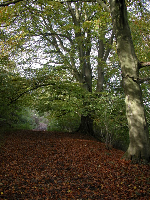
The forest is characterized by its dense, lush foliage consisting mainly of native broadleaf trees such as oak, beech, and ash. These towering trees provide a habitat for a diverse range of wildlife, including deer, foxes, squirrels, and various species of birds. The forest floor is adorned with a carpet of wildflowers, adding to the beauty of the surroundings.

Rugger's Green Wood offers a network of well-maintained trails that wind their way through the forest, providing visitors with the opportunity to explore its natural wonders. These paths cater to all levels of fitness, ranging from gentle strolls to more challenging hikes. Along the way, visitors can enjoy breathtaking views, discover hidden streams, and even stumble upon ancient ruins, adding an element of history to the experience.

The woodland is also a great spot for picnics and family outings, with designated areas equipped with picnic tables and benches. Furthermore, the forest is a popular location for educational visits, with local schools often organizing field trips to educate students about the importance of preserving natural habitats.

Rugger's Green Wood is easily accessible by both car and public transport, with ample parking available nearby. It provides a tranquil escape from the hustle and bustle of everyday life, allowing visitors to immerse themselves in the beauty of nature.

If you have any feedback on the listing, please let us know in the comments section below.

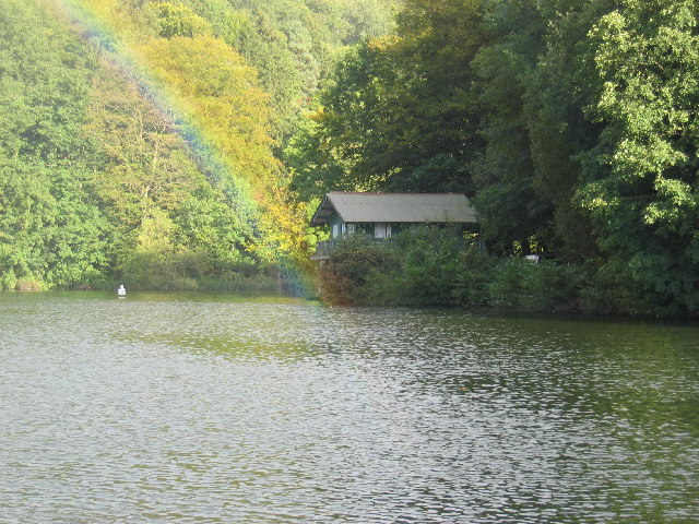
Rugger's Green Wood Images

Images are sourced within 2km of 51.684933/-2.2063792 or Grid Reference ST8598. Thanks to Geograph Open Source API. All images are credited.

Egypt Mill The stream that used to drive the water wheel when the Egypt Mill was a corn mill
Egypt Mill
The stream that used to drive the water wheel when the Egypt Mill was a corn mill
Inside Egypt Mill 450 years old, the Egypt Mill is now a hotel and diners can watch the waterwheel turning whilst eating a first class meal
Inside Egypt Mill
450 years old, the Egypt Mill is now a hotel and diners can watch the waterwheel turning whilst eating a first class meal
Egypt Mill Once owned by the Faroah family, we can see why this 450 year old building was called Egypt Mill.  It is now a hotel, but the water wheel still turns in the bar and there are various other trappings of a corn mill to be seen.
Egypt Mill
Once owned by the Faroah family, we can see why this 450 year old building was called Egypt Mill. It is now a hotel, but the water wheel still turns in the bar and there are various other trappings of a corn mill to be seen.
Nailsworth (Glos) St George's Church
Nailsworth Clock Memorial clock tower in village centre
Nailsworth Clock
Memorial clock tower in village centre
Gatcombe Water and boat house
Longfords Mills, Minchinhampton This was owned by William Playne and specialised in baize for snooker tables. Seen during conversion to dwellings. A water turbine and Belliss steam engine survive here.
Longfords Mills, Minchinhampton
This was owned by William Playne and specialised in baize for snooker tables. Seen during conversion to dwellings. A water turbine and Belliss steam engine survive here.
Nailsworth Fire Station Nailsworth Fire Station, Station Road, Nailsworth, Gloucestershire, with their two M.A.N. fire appliances.
Nailsworth Fire Station
Nailsworth Fire Station, Station Road, Nailsworth, Gloucestershire, with their two M.A.N. fire appliances.
The Bell and Castle public house, Horsley
Nailsworth Town Hall The town hall, made of local Cotswold stone, stands on the old Nailsworth - Bristol road.
Nailsworth Town Hall
The town hall, made of local Cotswold stone, stands on the old Nailsworth - Bristol road.
Horsley Mill Originally a woollen mill built in the 1800s, Horsley Mill has been renovated and is now part of Ruskin Mill College.
Horsley Mill
Originally a woollen mill built in the 1800s, Horsley Mill has been renovated and is now part of Ruskin Mill College.
Fishpond Originally the stream and ponds in this Cotswold valley were used to power the woollen mills which abounded here.  Now, however, this area is a fish farm and is part of Ruskin Mill College.
Fishpond
Originally the stream and ponds in this Cotswold valley were used to power the woollen mills which abounded here. Now, however, this area is a fish farm and is part of Ruskin Mill College.
New development in Worley A row of new houses, built in the traditional Cotswold stone, in the Worley area of Nailsworth.  The view is across a deep valley which carries Miry Brook.
New development in Worley
A row of new houses, built in the traditional Cotswold stone, in the Worley area of Nailsworth. The view is across a deep valley which carries Miry Brook.
Longfords Mill, Minchinhampton An earlier picture when the mills were still owned by Playnes but becoming somewhat moribund.
Longfords Mill, Minchinhampton
An earlier picture when the mills were still owned by Playnes but becoming somewhat moribund.
Tipputs Inn, Tiltups End Tipputs Inn is situated on the A46.
Tipputs Inn, Tiltups End
Tipputs Inn is situated on the A46.
Longman's Barn Farm, Avening A bridleway passes by this farm which is located high above a valley opposite Gatcombe Wood.
Longman's Barn Farm, Avening
A bridleway passes by this farm which is located high above a valley opposite Gatcombe Wood.
Bridleway through Hazel Wood This bridleway contours through Hazel Wood high above the valley below
Bridleway through Hazel Wood
This bridleway contours through Hazel Wood high above the valley below
Bridleway to Hazel Wood This bridleway is a continuation of Shiptons Grave Lane.
Bridleway to Hazel Wood
This bridleway is a continuation of Shiptons Grave Lane.
Show me another place!

Rugger's Green Wood is located at Grid Ref: ST8598 (Lat: 51.684933, Lng: -2.2063792)

Administrative County: Gloucestershire

District: Cotswold

Police Authority: Gloucestershire

What 3 Words

///ballooned.waggled.toddler. Near Nailsworth, Gloucestershire

Nearby Locations

Rugger's Green Wood

Related Wikis

Nailsworth Town Hall

Nailsworth Town Hall is a municipal building in Old Bristol Road in Nailsworth, Gloucestershire, England. The structure currently operates as the meeting...

Barton End

Barton End is a village just south of Nailsworth, Gloucestershire, England.

Ball's Green

Ball's Green is a hamlet in Gloucestershire, England. == External links == StreetMap.co.uk

Box Farm Meadows SSSI

Box Farm Meadows (Stuart Fawkes reserve) (grid reference ST865997) is a 8.3-hectare (21-acre) biological Site of Special Scientific Interest in Gloucestershire...

Related Videos

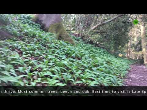
united Kingdom:Digital Trip to visit Box Woods by @krisztina.kapuvari | 2Morrow Trip

Come and #HopInOnline for #VirtualSights with #2MorrowDigitalTrips. Follow us on our channel ...

THE COTSWOLDS #happynewyear #walks #the #2024 #cotswolds #atmospheric #village #england #please 👍

A magical walk through Nailsworth near Stroud Gloucestershire. Well worth a visit any time of the year! Please Subscribe.

Two Hours in Minchinhampton

Minchinhampton is a small Gloucestershire town located between Cirencester and Stroud. Nearby is Gatcombe Park, hone to the ...

Nearby Amenities

Located within 500m of 51.684933,-2.2063792
Barrier: stile
Lat/Long: 51.6855287/-2.212164
Barrier: stile
Lat/Long: 51.6842037/-2.2086793
Ele: 193.589722
Wpt Description: TR
Lat/Long: 51.6841664/-2.2086106
Ele: 187.100830
Wpt Description: FP
Lat/Long: 51.6821452/-2.2119356
Barrier: kissing_gate
Lat/Long: 51.6851402/-2.2107736
Archaeological Site: tumulus
Historic: archaeological_site
Source: NPE
Lat/Long: 51.6870144/-2.2026883
Barrier: stile
Material: wood
Stile: stepover
Lat/Long: 51.6819637/-2.2063324
Barrier: stile
Material: wood
Stile: stepover
Lat/Long: 51.6858123/-2.2067348
Natural: spring
Lat/Long: 51.6871642/-2.2089941
Direction: 0
Historic: memorial
Inscription: Charles Holbrow Stoker First Class Royal Navy Lived Here at Rowan Cottage Killed 31st May 1916 aged 21 Commemorated on the Portsmouth Naval Memorial Lest We Forget
Material: metal
Memorial: plaque
Source: survey
Lat/Long: 51.6875107/-2.2122274
The data included in this document is from www.openstreetmap.org. The data is made available under ODbL.

Have you been to Rugger's Green Wood?

Leave your review of Rugger's Green Wood below (or comments, questions and feedback).