Bowling Green Wood

Wood, Forest in Dorset

England

Bowling Green Wood

Lulworth Castle A 17th-century hunting lodge erected in the style of a revival fortified castle, one of only five extant Elizabethan or Jacobean buildings of this type. It is listed with Historic England as a Scheduled monument
Lulworth Castle Credit: Graham Hogg

Bowling Green Wood is a picturesque forest located in the county of Dorset, England. Covering an area of approximately 300 acres, this wood is known for its natural beauty and diverse wildlife. It is situated near the village of Bowling Green, hence the name.

The wood features a variety of tree species, including oak, beech, and birch. The dense foliage creates a lush and vibrant environment, particularly during the spring and summer months when the forest is adorned with colorful wildflowers. The wood is also home to a number of wildlife species, such as deer, foxes, badgers, and a wide range of bird species.

In addition to its natural allure, Bowling Green Wood provides various recreational opportunities for visitors. There are several walking trails and paths that meander through the forest, allowing nature enthusiasts and hikers to explore the area at their leisure. These trails provide breathtaking views of the surrounding countryside and offer a serene escape from the hustle and bustle of everyday life.

The wood is managed by the local authorities, who ensure the preservation of its natural beauty and wildlife habitat. They also maintain the trails and provide informative signage to educate visitors about the flora and fauna found within the forest.

Overall, Bowling Green Wood is a tranquil and enchanting destination for nature lovers and those seeking a peaceful retreat. Its serene atmosphere, diverse wildlife, and stunning landscapes make it a must-visit location in Dorset.

If you have any feedback on the listing, please let us know in the comments section below.

Bowling Green Wood Images

Images are sourced within 2km of 50.643977/-2.2053719 or Grid Reference SY8582. Thanks to Geograph Open Source API. All images are credited.

Lulworth Castle A 17th-century hunting lodge erected in the style of a revival fortified castle, one of only five extant Elizabethan or Jacobean buildings of this type. It is listed with Historic England as a Scheduled monument
Lulworth Castle
A 17th-century hunting lodge erected in the style of a revival fortified castle, one of only five extant Elizabethan or Jacobean buildings of this type. It is listed with Historic England as a Scheduled monument
Coombe Keynes hamlet [1] East Coombe Farmhouse was probably built in the early 19th century in two builds. Constructed of brick with a stone gable wall, under a tile roof.
There are various lean-to later extensions. Listed, grade II, with details at: <span class="nowrap"><a title="https://historicengland.org.uk/listing/the-list/list-entry/1172277" rel="nofollow ugc noopener" href="https://historicengland.org.uk/listing/the-list/list-entry/1172277">Link</a><img style="margin-left:2px;" alt="External link" title="External link - shift click to open in new window" src="https://s1.geograph.org.uk/img/external.png" width="10" height="10"/></span>
Coombe Keynes is a hamlet, and depopulated village in Dorset, some 1½ miles south of Wool and about 5 miles southwest of Wareham. Extensive settlement remains have been found by excavation to the east of the church, indicating that once there were many more buildings. The area of earthworks, extending to some 20 acres, is a Scheduled Ancient Monument with details at: <span class="nowrap"><a title="https://historicengland.org.uk/listing/the-list/list-entry/1017260" rel="nofollow ugc noopener" href="https://historicengland.org.uk/listing/the-list/list-entry/1017260">Link</a><img style="margin-left:2px;" alt="External link" title="External link - shift click to open in new window" src="https://s1.geograph.org.uk/img/external.png" width="10" height="10"/></span>
Coombe Keynes hamlet [1]
East Coombe Farmhouse was probably built in the early 19th century in two builds. Constructed of brick with a stone gable wall, under a tile roof. There are various lean-to later extensions. Listed, grade II, with details at: LinkExternal link Coombe Keynes is a hamlet, and depopulated village in Dorset, some 1½ miles south of Wool and about 5 miles southwest of Wareham. Extensive settlement remains have been found by excavation to the east of the church, indicating that once there were many more buildings. The area of earthworks, extending to some 20 acres, is a Scheduled Ancient Monument with details at: LinkExternal link
Coombe Keynes hamlet [2] This early 19th century boundary wall, east of East Coombe Farmhouse, is constructed of brick and stone, with tiled capping. There is a similar, but lower wall in front of the house. Listed, for group value, grade II, with details at: <span class="nowrap"><a title="https://historicengland.org.uk/listing/the-list/list-entry/1120494" rel="nofollow ugc noopener" href="https://historicengland.org.uk/listing/the-list/list-entry/1120494">Link</a><img style="margin-left:2px;" alt="External link" title="External link - shift click to open in new window" src="https://s1.geograph.org.uk/img/external.png" width="10" height="10"/></span>
Coombe Keynes is a hamlet, and depopulated village in Dorset, some 1½ miles south of Wool and about 5 miles southwest of Wareham. Extensive settlement remains have been found by excavation to the east of the church, indicating that once there were many more buildings. The area of earthworks, extending to some 20 acres, is a Scheduled Ancient Monument with details at: <span class="nowrap"><a title="https://historicengland.org.uk/listing/the-list/list-entry/1017260" rel="nofollow ugc noopener" href="https://historicengland.org.uk/listing/the-list/list-entry/1017260">Link</a><img style="margin-left:2px;" alt="External link" title="External link - shift click to open in new window" src="https://s1.geograph.org.uk/img/external.png" width="10" height="10"/></span>
Coombe Keynes hamlet [2]
This early 19th century boundary wall, east of East Coombe Farmhouse, is constructed of brick and stone, with tiled capping. There is a similar, but lower wall in front of the house. Listed, for group value, grade II, with details at: LinkExternal link Coombe Keynes is a hamlet, and depopulated village in Dorset, some 1½ miles south of Wool and about 5 miles southwest of Wareham. Extensive settlement remains have been found by excavation to the east of the church, indicating that once there were many more buildings. The area of earthworks, extending to some 20 acres, is a Scheduled Ancient Monument with details at: LinkExternal link
Coombe Keynes hamlet [4] The curiously named Odd Nod is a cottage in a terrace, probably built in the early 19th century. Constructed of rubble stone with brick dressings under a thatch roof. Some original internal features remain. Listed, grade II, with details at: <span class="nowrap"><a title="https://historicengland.org.uk/listing/the-list/list-entry/1172303" rel="nofollow ugc noopener" href="https://historicengland.org.uk/listing/the-list/list-entry/1172303">Link</a><img style="margin-left:2px;" alt="External link" title="External link - shift click to open in new window" src="https://s1.geograph.org.uk/img/external.png" width="10" height="10"/></span>
Coombe Keynes is a hamlet, and depopulated village in Dorset, some 1½ miles south of Wool and about 5 miles southwest of Wareham. Extensive settlement remains have been found by excavation to the east of the church, indicating that once there were many more buildings. The area of earthworks, extending to some 20 acres, is a Scheduled Ancient Monument with details at: <span class="nowrap"><a title="https://historicengland.org.uk/listing/the-list/list-entry/1017260" rel="nofollow ugc noopener" href="https://historicengland.org.uk/listing/the-list/list-entry/1017260">Link</a><img style="margin-left:2px;" alt="External link" title="External link - shift click to open in new window" src="https://s1.geograph.org.uk/img/external.png" width="10" height="10"/></span>
Coombe Keynes hamlet [4]
The curiously named Odd Nod is a cottage in a terrace, probably built in the early 19th century. Constructed of rubble stone with brick dressings under a thatch roof. Some original internal features remain. Listed, grade II, with details at: LinkExternal link Coombe Keynes is a hamlet, and depopulated village in Dorset, some 1½ miles south of Wool and about 5 miles southwest of Wareham. Extensive settlement remains have been found by excavation to the east of the church, indicating that once there were many more buildings. The area of earthworks, extending to some 20 acres, is a Scheduled Ancient Monument with details at: LinkExternal link
Coombe Keynes hamlet [5] The curiously named Mini Nod is a cottage in a terrace, probably built in the early 19th century. Constructed of rubble stone with brick dressings under a thatch roof. Some original internal features remain. Listed, grade II, with details at: <span class="nowrap"><a title="https://historicengland.org.uk/listing/the-list/list-entry/1305228" rel="nofollow ugc noopener" href="https://historicengland.org.uk/listing/the-list/list-entry/1305228">Link</a><img style="margin-left:2px;" alt="External link" title="External link - shift click to open in new window" src="https://s1.geograph.org.uk/img/external.png" width="10" height="10"/></span>
Coombe Keynes is a hamlet, and depopulated village in Dorset, some 1½ miles south of Wool and about 5 miles southwest of Wareham. Extensive settlement remains have been found by excavation to the east of the church, indicating that once there were many more buildings. The area of earthworks, extending to some 20 acres, is a Scheduled Ancient Monument with details at: <span class="nowrap"><a title="https://historicengland.org.uk/listing/the-list/list-entry/1017260" rel="nofollow ugc noopener" href="https://historicengland.org.uk/listing/the-list/list-entry/1017260">Link</a><img style="margin-left:2px;" alt="External link" title="External link - shift click to open in new window" src="https://s1.geograph.org.uk/img/external.png" width="10" height="10"/></span>
Coombe Keynes hamlet [5]
The curiously named Mini Nod is a cottage in a terrace, probably built in the early 19th century. Constructed of rubble stone with brick dressings under a thatch roof. Some original internal features remain. Listed, grade II, with details at: LinkExternal link Coombe Keynes is a hamlet, and depopulated village in Dorset, some 1½ miles south of Wool and about 5 miles southwest of Wareham. Extensive settlement remains have been found by excavation to the east of the church, indicating that once there were many more buildings. The area of earthworks, extending to some 20 acres, is a Scheduled Ancient Monument with details at: LinkExternal link
Coombe Keynes hamlet [6] The curiously named Cuckoo Nod is a cottage in a terrace, probably built in the early 19th century. Constructed of rubble stone with brick dressings under a thatch roof. A single-storey extension is of brick under a tile roof. Some original internal features remain. Listed, grade II, with details at: <span class="nowrap"><a title="https://historicengland.org.uk/listing/the-list/list-entry/1120492" rel="nofollow ugc noopener" href="https://historicengland.org.uk/listing/the-list/list-entry/1120492">Link</a><img style="margin-left:2px;" alt="External link" title="External link - shift click to open in new window" src="https://s1.geograph.org.uk/img/external.png" width="10" height="10"/></span>
Coombe Keynes is a hamlet, and depopulated village in Dorset, some 1½ miles south of Wool and about 5 miles southwest of Wareham. Extensive settlement remains have been found by excavation to the east of the church, indicating that once there were many more buildings. The area of earthworks, extending to some 20 acres, is a Scheduled Ancient Monument with details at: <span class="nowrap"><a title="https://historicengland.org.uk/listing/the-list/list-entry/1017260" rel="nofollow ugc noopener" href="https://historicengland.org.uk/listing/the-list/list-entry/1017260">Link</a><img style="margin-left:2px;" alt="External link" title="External link - shift click to open in new window" src="https://s1.geograph.org.uk/img/external.png" width="10" height="10"/></span>
Coombe Keynes hamlet [6]
The curiously named Cuckoo Nod is a cottage in a terrace, probably built in the early 19th century. Constructed of rubble stone with brick dressings under a thatch roof. A single-storey extension is of brick under a tile roof. Some original internal features remain. Listed, grade II, with details at: LinkExternal link Coombe Keynes is a hamlet, and depopulated village in Dorset, some 1½ miles south of Wool and about 5 miles southwest of Wareham. Extensive settlement remains have been found by excavation to the east of the church, indicating that once there were many more buildings. The area of earthworks, extending to some 20 acres, is a Scheduled Ancient Monument with details at: LinkExternal link
Coombe Keynes hamlet [8] Numbers 7 and 8 Main Street, were originally built in the 17th century and converted to two cottages in the 19th century. Constructed of rubble stone, partly roughcast, under a thatch roof. The extension on the right is of brick under a tile roof. Some windows are horizontally sliding sashes. Listed, grade II, with details at: <span class="nowrap"><a title="https://historicengland.org.uk/listing/the-list/list-entry/1323337" rel="nofollow ugc noopener" href="https://historicengland.org.uk/listing/the-list/list-entry/1323337">Link</a><img style="margin-left:2px;" alt="External link" title="External link - shift click to open in new window" src="https://s1.geograph.org.uk/img/external.png" width="10" height="10"/></span>
Coombe Keynes is a hamlet, and depopulated village in Dorset, some 1½ miles south of Wool and about 5 miles southwest of Wareham. Extensive settlement remains have been found by excavation to the east of the church, indicating that once there were many more buildings. The area of earthworks, extending to some 20 acres, is a Scheduled Ancient Monument with details at: <span class="nowrap"><a title="https://historicengland.org.uk/listing/the-list/list-entry/1017260" rel="nofollow ugc noopener" href="https://historicengland.org.uk/listing/the-list/list-entry/1017260">Link</a><img style="margin-left:2px;" alt="External link" title="External link - shift click to open in new window" src="https://s1.geograph.org.uk/img/external.png" width="10" height="10"/></span>
Coombe Keynes hamlet [8]
Numbers 7 and 8 Main Street, were originally built in the 17th century and converted to two cottages in the 19th century. Constructed of rubble stone, partly roughcast, under a thatch roof. The extension on the right is of brick under a tile roof. Some windows are horizontally sliding sashes. Listed, grade II, with details at: LinkExternal link Coombe Keynes is a hamlet, and depopulated village in Dorset, some 1½ miles south of Wool and about 5 miles southwest of Wareham. Extensive settlement remains have been found by excavation to the east of the church, indicating that once there were many more buildings. The area of earthworks, extending to some 20 acres, is a Scheduled Ancient Monument with details at: LinkExternal link
St Andrew's Church  The tower of St Andrew's Church was built in the late 15th century. The rest of the church was rebuilt in 1864.
St Andrew's Church
The tower of St Andrew's Church was built in the late 15th century. The rest of the church was rebuilt in 1864.
St Andrew's Church  The tower of St Andrew's Church was built in the late 15th century. The rest of the church was rebuilt in 1864.
St Andrew's Church
The tower of St Andrew's Church was built in the late 15th century. The rest of the church was rebuilt in 1864.
Fields at East Lulworth
The Old School Former school is now a souvenir shop.
The Old School
Former school is now a souvenir shop.
Electricity substation
Thatched cottage For a brief history see <a href="https://www.geograph.org.uk/photo/366188">SY8581 : Manor Cottage</a>
Thatched cottage
For a brief history see SY8581 : Manor Cottage
Pub car park The Weld Arms  is an public house in East Lulworth.  The pub's own web site claims it is 17th century, but the Historic England listing says 18th century.  The name comes from the Weld family who bought the village in 1640, and who still own the Castle and the Pub.   In 1770 the pub landlord was one Richard Champ, a notorious local smuggler.

This is a grade II listed building - see <span class="nowrap"><a title="https://historicengland.org.uk/listing/the-list/list-entry/1172406" rel="nofollow ugc noopener" href="https://historicengland.org.uk/listing/the-list/list-entry/1172406">Link</a><img style="margin-left:2px;" alt="External link" title="External link - shift click to open in new window" src="https://s1.geograph.org.uk/img/external.png" width="10" height="10"/></span>

The pub's own web site is at <span class="nowrap"><a title="http://www.weldarms.co.uk/" rel="nofollow ugc noopener" href="http://www.weldarms.co.uk/">Link</a><img style="margin-left:2px;" alt="External link" title="External link - shift click to open in new window" src="https://s1.geograph.org.uk/img/external.png" width="10" height="10"/></span> 
An account of the village history, including the Inn, is at <span class="nowrap"><a title="http://www.dorsetlife.co.uk/2013/10/dorset-village-walk-east-lulworth/" rel="nofollow ugc noopener" href="http://www.dorsetlife.co.uk/2013/10/dorset-village-walk-east-lulworth/">Link</a><img style="margin-left:2px;" alt="External link" title="External link - shift click to open in new window" src="https://s1.geograph.org.uk/img/external.png" width="10" height="10"/></span>
Pub car park
The Weld Arms is an public house in East Lulworth. The pub's own web site claims it is 17th century, but the Historic England listing says 18th century. The name comes from the Weld family who bought the village in 1640, and who still own the Castle and the Pub. In 1770 the pub landlord was one Richard Champ, a notorious local smuggler. This is a grade II listed building - see LinkExternal link The pub's own web site is at LinkExternal link An account of the village history, including the Inn, is at LinkExternal link
Garage doors Looking run down but with a modern padlock.
Garage doors
Looking run down but with a modern padlock.
The Weld Arms I was amused by the table on the 'traffic island', but the land to the left of the island is part of the pub, not the public highway
The Weld Arms
I was amused by the table on the 'traffic island', but the land to the left of the island is part of the pub, not the public highway
Pub Entrance The Weld Arms  is an public house in East Lulworth.  The pub's own web site claims it is 17th century, but the Historic England listing says 18th century.  The name comes from the Weld family who bought the village in 1640, and who still own the Castle and the Pub.   In 1770 the pub landlord was one Richard Champ, a notorious local smuggler.

This is a grade II listed building - see <span class="nowrap"><a title="https://historicengland.org.uk/listing/the-list/list-entry/1172406" rel="nofollow ugc noopener" href="https://historicengland.org.uk/listing/the-list/list-entry/1172406">Link</a><img style="margin-left:2px;" alt="External link" title="External link - shift click to open in new window" src="https://s1.geograph.org.uk/img/external.png" width="10" height="10"/></span>

The pub's own web site is at <span class="nowrap"><a title="http://www.weldarms.co.uk/" rel="nofollow ugc noopener" href="http://www.weldarms.co.uk/">Link</a><img style="margin-left:2px;" alt="External link" title="External link - shift click to open in new window" src="https://s1.geograph.org.uk/img/external.png" width="10" height="10"/></span> 
An account of the village history, including the Inn, is at <span class="nowrap"><a title="http://www.dorsetlife.co.uk/2013/10/dorset-village-walk-east-lulworth/" rel="nofollow ugc noopener" href="http://www.dorsetlife.co.uk/2013/10/dorset-village-walk-east-lulworth/">Link</a><img style="margin-left:2px;" alt="External link" title="External link - shift click to open in new window" src="https://s1.geograph.org.uk/img/external.png" width="10" height="10"/></span>
Pub Entrance
The Weld Arms is an public house in East Lulworth. The pub's own web site claims it is 17th century, but the Historic England listing says 18th century. The name comes from the Weld family who bought the village in 1640, and who still own the Castle and the Pub. In 1770 the pub landlord was one Richard Champ, a notorious local smuggler. This is a grade II listed building - see LinkExternal link The pub's own web site is at LinkExternal link An account of the village history, including the Inn, is at LinkExternal link
Pub sign The Weld Arms  is an public house in East Lulworth.  The pub's own web site claims it is 17th century, but the Historic England listing says 18th century.  The name comes from the Weld family who bought the village in 1640, and who still own the Castle and the Pub.   In 1770 the pub landlord was one Richard Champ, a notorious local smuggler.

This is a grade II listed building - see <span class="nowrap"><a title="https://historicengland.org.uk/listing/the-list/list-entry/1172406" rel="nofollow ugc noopener" href="https://historicengland.org.uk/listing/the-list/list-entry/1172406">Link</a><img style="margin-left:2px;" alt="External link" title="External link - shift click to open in new window" src="https://s1.geograph.org.uk/img/external.png" width="10" height="10"/></span>

The pub's own web site is at <span class="nowrap"><a title="http://www.weldarms.co.uk/" rel="nofollow ugc noopener" href="http://www.weldarms.co.uk/">Link</a><img style="margin-left:2px;" alt="External link" title="External link - shift click to open in new window" src="https://s1.geograph.org.uk/img/external.png" width="10" height="10"/></span> 
An account of the village history, including the Inn, is at <span class="nowrap"><a title="http://www.dorsetlife.co.uk/2013/10/dorset-village-walk-east-lulworth/" rel="nofollow ugc noopener" href="http://www.dorsetlife.co.uk/2013/10/dorset-village-walk-east-lulworth/">Link</a><img style="margin-left:2px;" alt="External link" title="External link - shift click to open in new window" src="https://s1.geograph.org.uk/img/external.png" width="10" height="10"/></span>
Pub sign
The Weld Arms is an public house in East Lulworth. The pub's own web site claims it is 17th century, but the Historic England listing says 18th century. The name comes from the Weld family who bought the village in 1640, and who still own the Castle and the Pub. In 1770 the pub landlord was one Richard Champ, a notorious local smuggler. This is a grade II listed building - see LinkExternal link The pub's own web site is at LinkExternal link An account of the village history, including the Inn, is at LinkExternal link
Show me another place!

Bowling Green Wood is located at Grid Ref: SY8582 (Lat: 50.643977, Lng: -2.2053719)

Unitary Authority: Dorset

Police Authority: Dorset

What 3 Words

///turned.combines.torso. Near Wool, Dorset

Related Wikis

East Lulworth

East Lulworth is a village and civil parish nine miles east of Dorchester, near Lulworth Cove, in the county of Dorset, South West England. It consists...

Bestival

Bestival was a four-day music festival held in the south of England. The name Bestival is a portmanteau of the words best and festival. It had been held...
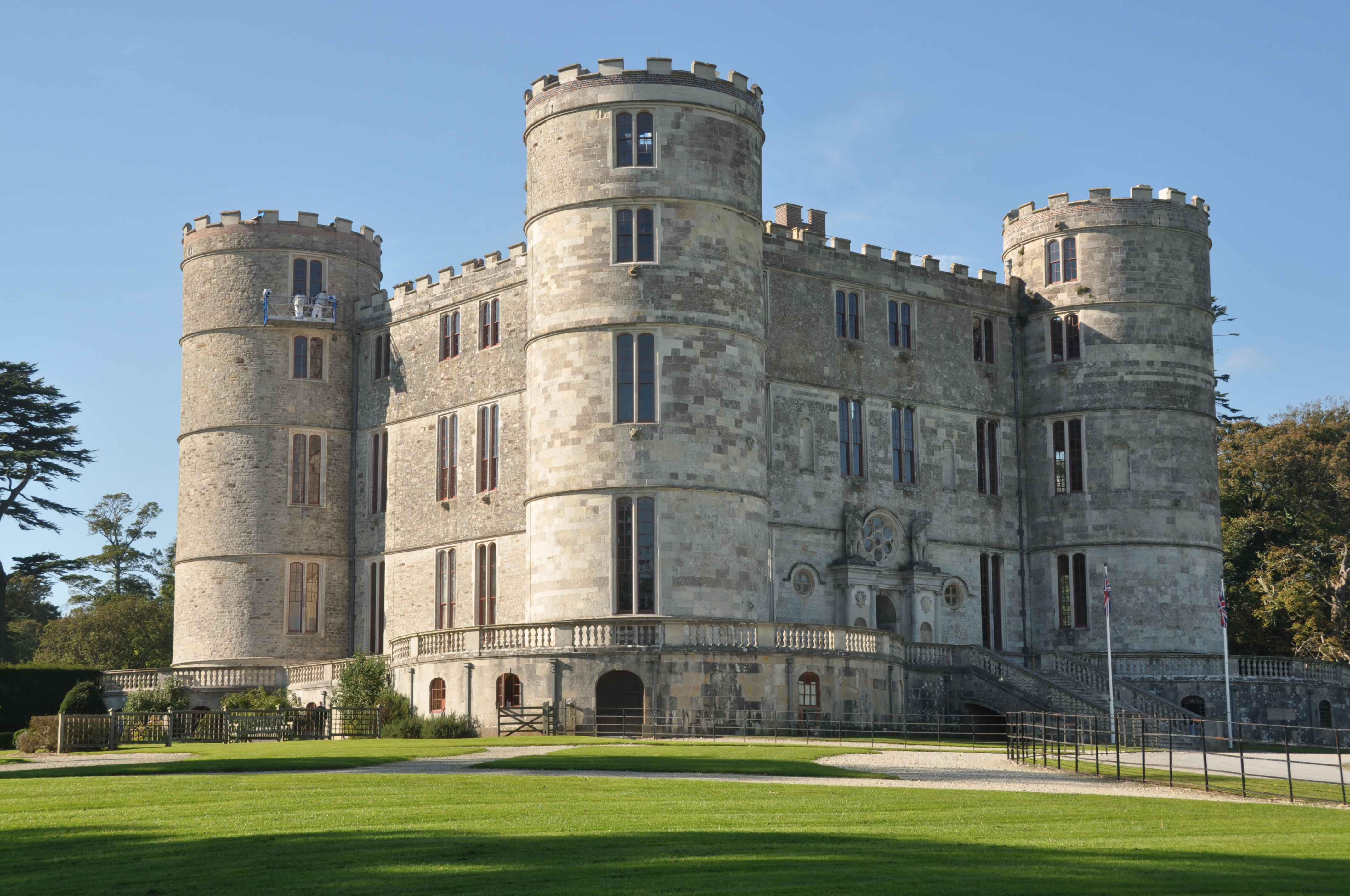
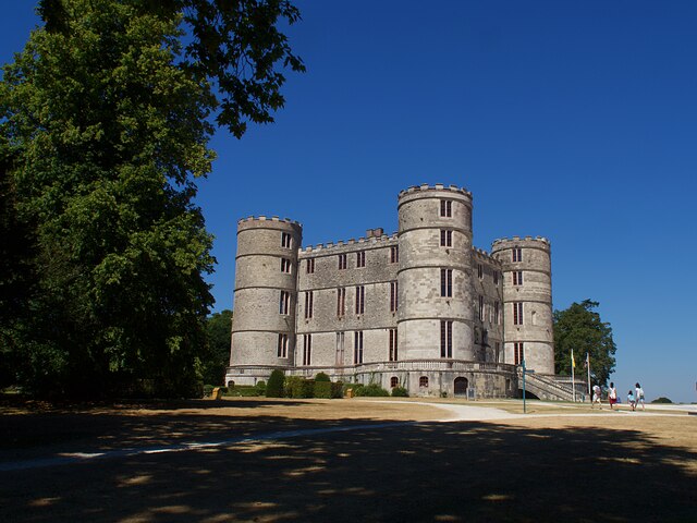
Lulworth Castle

Lulworth Castle, in East Lulworth, Dorset, England, situated south of the village of Wool, is an early 17th-century hunting lodge erected in the style...

Lulworth Estate

The Lulworth Estate is a country estate located in central south Dorset, England. Its most notable landscape feature is a five-mile stretch of coastline...

Lulworth Abbey

Lulworth Abbey was a Trappist monastery at East Lulworth in Dorset, England, established as a priory in 1796 by Thomas Weld for refugee French Trappist...

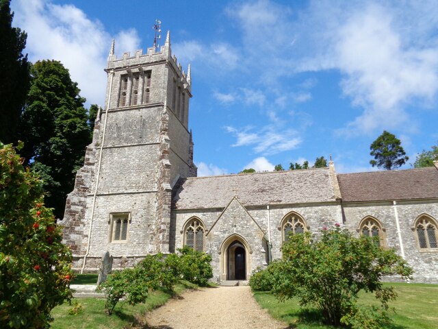
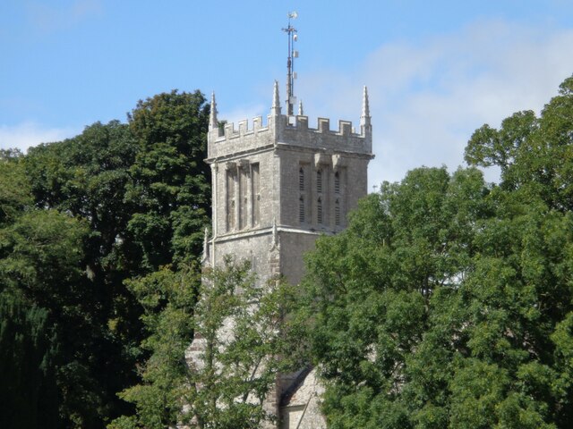
Holy Rood Church, Coombe Keynes

Holy Rood Church is a former Church of England church in Coombe Keynes, Dorset, England. Most of the church dates to a rebuild of 1860–61, but the tower...

Coombe Keynes

Coombe Keynes is a hamlet, civil parish and depopulated village in the Purbeck district of Dorset, England. The village is about 2 miles (3 km) south of...

Lulworth Camp

Lulworth Camp is a British Army base that is home to the Armoured Fighting Vehicle Gunnery School and runs the Lulworth Ranges on the southern coast of...

Nearby Amenities

Located within 500m of 50.643977,-2.2053719
Post Box
Brand: Royal Mail
Brand Wikidata: Q638098
Collection Times: Mo-Fr 10:15; Sa 09:00
Drive Through: no
Operator: Royal Mail
Operator Wikidata: Q638098
Post Box Type: lamp
Ref: BH20 88
Source: survey
Lat/Long: 50.6483025/-2.2059685
Booth: K6
Covered: booth
Disused Amenity: telephone
Man Made: telephone_box
Note: Box exists, phone removed
Old Phone: +44 1929 400206
Lat/Long: 50.6482577/-2.2059153
Fire Hydrant
Emergency: fire_hydrant
Fire Hydrant Diameter: 100
Fire Hydrant Type: underground
Ref: 795
Source: GPS
Lat/Long: 50.6482949/-2.2057973
Grit Bin
Ref: 4-69
Source: GPS
Lat/Long: 50.6483098/-2.2059767
Access: private
Barrier: swing_gate
Foot: permissive
Locked: no
Material: wood
Motor Vehicle: no
Lat/Long: 50.6417615/-2.2075306
Power: pole
Source: bing
Switch: mechanical
Lat/Long: 50.6417251/-2.2085772
Power: pole
Source: bing
Lat/Long: 50.6418943/-2.2105097
Power: pole
Source: bing
Lat/Long: 50.6424965/-2.2100658
Power: pole
Source: bing
Lat/Long: 50.6430986/-2.209654
Power: pole
Source: bing
Lat/Long: 50.6436973/-2.2092463
Power: pole
Source: bing
Lat/Long: 50.644291/-2.208848
Power: pole
Source: bing
Lat/Long: 50.6449084/-2.2084363
Power: pole
Source: bing
Lat/Long: 50.6454943/-2.2080313
Power: pole
Source: bing
Lat/Long: 50.64607/-2.2076384
Power: pole
Source: bing
Lat/Long: 50.6465726/-2.2073084
Power: pole
Source: bing
Transformer: distribution
Lat/Long: 50.6472147/-2.2068766
Power: pole
Source: bing
Lat/Long: 50.6472491/-2.2074285
Power: pole
Source: bing
Lat/Long: 50.6472848/-2.207973
Power: pole
Source: bing
Lat/Long: 50.6473154/-2.2085899
Power: pole
Source: bing
Lat/Long: 50.6473529/-2.2092041
Power: pole
Source: bing
Lat/Long: 50.6474022/-2.2098881
Power: pole
Source: bing
Lat/Long: 50.647633/-2.2060867
Power: pole
Source: bing
Transformer: distribution
Lat/Long: 50.6481527/-2.2052297
Power: pole
Source: bing
Lat/Long: 50.648301/-2.2038115
Barrier: swing_gate
Lat/Long: 50.6467071/-2.2106486
Access: private
Barrier: swing_gate
Foot: permissive
Horse: permit
Locked: no
Motor Vehicle: no
Lat/Long: 50.6453341/-2.2060266
Board Type: notice
Information: board
Tourism: information
Lat/Long: 50.6483466/-2.2060657
Power: pole
Source: bing
Lat/Long: 50.6472291/-2.2070865
Power: pole
Source: bing
Lat/Long: 50.6478845/-2.2056889
Power: pole
Source: bing
Lat/Long: 50.6465939/-2.2042032
Power: pole
Source: bing
Transformer: distribution
Lat/Long: 50.645024/-2.2029787
Power: pole
Source: bing
Lat/Long: 50.6472461/-2.2049502
Power: pole
Source: bing
Lat/Long: 50.6457851/-2.2035769
Access: customers
Leisure: picnic_table
Lat/Long: 50.6412248/-2.2057182
Access: customers
Leisure: playground
Lat/Long: 50.6413165/-2.2057284
The data included in this document is from www.openstreetmap.org. The data is made available under ODbL.

Have you been to Bowling Green Wood?

Leave your review of Bowling Green Wood below (or comments, questions and feedback).