Dinnetley Wood

Wood, Forest in Northumberland

England

Dinnetley Wood

Haydon Bridge Station carpark viewed through station platform fence This side for trains to Carlisle.
Haydon Bridge Station carpark viewed through station platform fence Credit: Luke Shaw

Dinnetley Wood is a picturesque forest located in Northumberland, England. Covering an area of approximately 500 acres, this ancient woodland is renowned for its natural beauty and diverse ecosystem. The wood is situated near the village of Dinnetley and is easily accessible to visitors.

The forest boasts a wide range of tree species, including oak, birch, and beech, which create a dense canopy that filters sunlight and creates a tranquil atmosphere. The woodland floor is carpeted with a variety of wildflowers, such as bluebells and primroses, which bloom in spring, adding vibrant colors to the landscape.

Dinnetley Wood is a haven for wildlife enthusiasts, as it is home to a rich assortment of animal species. Visitors may be lucky enough to spot roe deer, foxes, badgers, and a variety of birdlife, including woodpeckers, owls, and warblers. The forest also supports a diverse insect population, with butterflies and dragonflies fluttering among the trees.

The wood offers a range of walking trails for visitors to explore. These paths wind through the forest, providing opportunities to discover hidden glades, babbling brooks, and small ponds. The tranquil atmosphere of the woodland makes it a popular spot for nature lovers, hikers, and photographers.

Visitors to Dinnetley Wood can enjoy a picnic in one of the designated areas or simply relax and soak in the peaceful ambiance. The forest is open year-round, and each season brings its own unique charm, from the vibrant hues of autumn to the fresh green growth of spring.

Overall, Dinnetley Wood is a remarkable natural treasure in Northumberland, offering visitors a chance to immerse themselves in the beauty and tranquility of a truly enchanting woodland setting.

If you have any feedback on the listing, please let us know in the comments section below.

Dinnetley Wood Images

Images are sourced within 2km of 54.960155/-2.2356109 or Grid Reference NY8562. Thanks to Geograph Open Source API. All images are credited.

Haydon Bridge Station carpark viewed through station platform fence This side for trains to Carlisle.
Haydon Bridge Station carpark viewed through station platform fence
This side for trains to Carlisle.
Benchmark on stone wall on NE side of North Bank Ordnance Survey cut mark benchmark levelled at 70.455m above Newlyn Datum verified 1954
Benchmark on stone wall on NE side of North Bank
Ordnance Survey cut mark benchmark levelled at 70.455m above Newlyn Datum verified 1954
Looking NW along North Bank as it passes Haydon Lodge There is an Ordnance Survey benchmark <a href="https://www.geograph.org.uk/photo/7106376">NY8464 : Benchmark on stone wall on NE side of North Bank</a> on the stone wall about 2m right of its corner near the right hand edge of the image
Looking NW along North Bank as it passes Haydon Lodge
There is an Ordnance Survey benchmark NY8464 : Benchmark on stone wall on NE side of North Bank on the stone wall about 2m right of its corner near the right hand edge of the image
Benchmark on St Cuthbert's Church Ordnance Survey 1GL bolt benchmark levelled at 64.535m above Newlyn Datum verified 1954. The mark was previously levelled at 211.499 feet above Liverpool Datum during the 1GL Carlisle to North Shields survey of 1844-1845. The surveyor's description was 'No. 106. Bolt in South-west corner of tower of Haydonbridge Parish Church ; 2.12 ft. above surface'
Benchmark on St Cuthbert's Church
Ordnance Survey 1GL bolt benchmark levelled at 64.535m above Newlyn Datum verified 1954. The mark was previously levelled at 211.499 feet above Liverpool Datum during the 1GL Carlisle to North Shields survey of 1844-1845. The surveyor's description was 'No. 106. Bolt in South-west corner of tower of Haydonbridge Parish Church ; 2.12 ft. above surface'
St Cuthbert's Church on east side of Church Street There is an Ordnance Survey benchmark <a href="https://www.geograph.org.uk/photo/7115512">NY8464 : Benchmark on St Cuthbert's Church</a> on the near corner, left hand face, of the church tower
St Cuthbert's Church on east side of Church Street
There is an Ordnance Survey benchmark NY8464 : Benchmark on St Cuthbert's Church on the near corner, left hand face, of the church tower
Benchmark on St John of Beverley Church Ordnance Survey cut mark benchmark levelled at 75.993m above Newlyn Datum verified 1954
Benchmark on St John of Beverley Church
Ordnance Survey cut mark benchmark levelled at 75.993m above Newlyn Datum verified 1954
St John of Beverley Roman Catholic Church
Benchmark on roadside wall right of subway entrance on SE side of Station Road Ordnance Survey cut mark benchmark levelled at 62.258m above Newlyn Datum verified in 1954
Benchmark on roadside wall right of subway entrance on SE side of Station Road
Ordnance Survey cut mark benchmark levelled at 62.258m above Newlyn Datum verified in 1954
Subway under railway line on SE side of Station Road (B6319) There is an Ordnance Survey benchmark <a href="https://www.geograph.org.uk/photo/7116739">NY8464 : Benchmark on roadside wall right of subway entrance on SE side of Station Road</a> on the wall pier on the right hand side of the subway entrance tunnel which takes a footpath under the Carlisle to Newcastle railway to the side of the South Tyne
Subway under railway line on SE side of Station Road (B6319)
There is an Ordnance Survey benchmark NY8464 : Benchmark on roadside wall right of subway entrance on SE side of Station Road on the wall pier on the right hand side of the subway entrance tunnel which takes a footpath under the Carlisle to Newcastle railway to the side of the South Tyne
Haydon Bridge & Allendale Medical Practice, North Bank, Haydon Bridge
Shaftoe Terrace, Haydon Bridge A group of almshouses built by the Greenwich Hospital Commissioners in c.1805.
Shaftoe Terrace, Haydon Bridge
A group of almshouses built by the Greenwich Hospital Commissioners in c.1805.
Junction of John Martin Street, Haydon Bridge Showing houses of Wittis Row.
Junction of John Martin Street, Haydon Bridge
Showing houses of Wittis Row.
River South Tyne at Old Haydon Bridge The old six-arched stone bridge in Haydon Bridge was constructed in 1776 but was partly rebuilt following later collapses. A new concrete bridge to its east (from where this photo was taken) which took the A69 main road across the river was opened in 1970 although that route now bypasses the town on the south side of the river. The old bridge has been restored for pedestrian use and is Grade 2 listed.
River South Tyne at Old Haydon Bridge
The old six-arched stone bridge in Haydon Bridge was constructed in 1776 but was partly rebuilt following later collapses. A new concrete bridge to its east (from where this photo was taken) which took the A69 main road across the river was opened in 1970 although that route now bypasses the town on the south side of the river. The old bridge has been restored for pedestrian use and is Grade 2 listed.
Information board, 'Crossing the River South Tyne', Haydon Bridge
Level crossing, Haydon Bridge Railway Station
California (Allotment) Gardens, Haydon Bridge Stone Holt <a href="https://www.geograph.org.uk/photo/6419750">NY8464 : Stone Halt, Haydon Bridge</a> is on the left side and Alexandra Terrace behind. There is a similar photo here <a href="https://www.geograph.org.uk/photo/2069519">NY8464 : Allotments, Station Road</a>.
California (Allotment) Gardens, Haydon Bridge
Stone Holt NY8464 : Stone Halt, Haydon Bridge is on the left side and Alexandra Terrace behind. There is a similar photo here NY8464 : Allotments, Station Road.
Former railway building, Haydon Bridge Railway Station A two-storey brick-built building on the Carlisle platform at Haydon Bridge Railway Station. See another photo here <a href="https://www.geograph.org.uk/photo/5931109">NY8464 : Former station building, Haydon Bridge</a>. The track gradient markers to  the left of the house are shown here <a href="https://www.geograph.org.uk/photo/6419733">NY8464 : Haydon Bridge station - gradient markers</a>.
Former railway building, Haydon Bridge Railway Station
A two-storey brick-built building on the Carlisle platform at Haydon Bridge Railway Station. See another photo here NY8464 : Former station building, Haydon Bridge. The track gradient markers to the left of the house are shown here NY8464 : Haydon Bridge station - gradient markers.
NCR ticket machine, Haydon Bridge Railway Station Commemorating the life of the late Queen, Elizabeth II, who died on 8th September 2022.
NCR ticket machine, Haydon Bridge Railway Station
Commemorating the life of the late Queen, Elizabeth II, who died on 8th September 2022.
Show me another place!

Dinnetley Wood is located at Grid Ref: NY8562 (Lat: 54.960155, Lng: -2.2356109)

Unitary Authority: Northumberland

Police Authority: Northumbria

What 3 Words

///broadcast.bashed.pillow. Near Haydon Bridge, Northumberland

Nearby Locations

Dinnetley Wood

Related Wikis

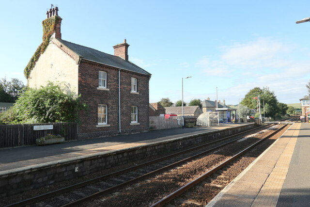
Elrington Halt railway station

Elrington Halt station is a closed stone-built railway station situated on a single-track branch railway line in Northumberland, England, that runs from...
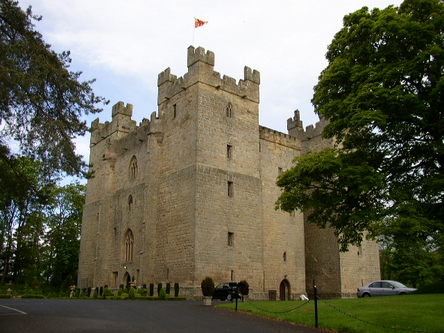
Langley Castle

Langley Castle is a restored medieval tower house, now operated as a hotel, situated in the village of Langley in the valley of the River South Tyne some...
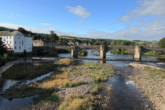
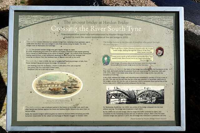
Haydon Bridge

Haydon Bridge is a village in Northumberland, England, which had a population of 2,184 in the 2011 census. Its most distinctive features are the two bridges...

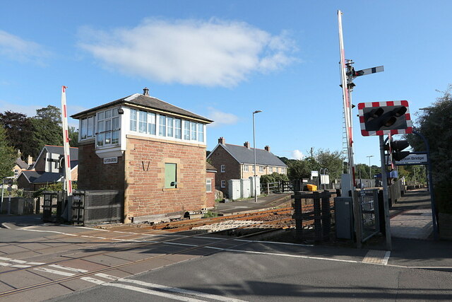
Haydon Bridge railway station

Haydon Bridge is a railway station on the Tyne Valley Line, which runs between Newcastle and Carlisle via Hexham. The station, situated 29 miles 68 chains...

Haydon Bridge High School

Haydon Bridge High School is a mixed secondary day school located in Haydon Bridge in the English county of Northumberland. The current headteacher is...

Langley-on-Tyne railway station

Langley-on-Tyne is a closed stone built railway station situated on a single track branch railway line in Northumberland, England, that ran from Allendale...

Langley, Northumberland

Langley or Langley-on-Tyne is a small village in Northumberland, England, located to the west of Hexham. The village is on the A686 about 3 miles (5 km...

Chesterwood

Chesterwood is a hamlet in Northumberland, in England. It is situated a short distance to the north-west of Haydon Bridge on the South Tyne, west of Hexham...

Have you been to Dinnetley Wood?

Leave your review of Dinnetley Wood below (or comments, questions and feedback).