Middle Wood

Wood, Forest in Staffordshire South Staffordshire

England

Middle Wood

Disused Buildings, near Cranmoor Lodge Farm, Perton The Staffordshire Way passes these military style buildings, all disused but with roofs intact, in the corner of a large grass covered field. Apparently they are the remains of  2nd World War RAF Perton accommodation, later used to house Dutch Army barracks.

There are threats to close the footpath to enable development. The exact original use of all the buildings here can be dug out from these planning applications: <span class="nowrap"><a title="http://www.sstaffs.gov.uk/pdf/Regulatory%20Committee%2022nd%20May%202007.pdf" rel="nofollow ugc noopener" href="http://www.sstaffs.gov.uk/pdf/Regulatory%20Committee%2022nd%20May%202007.pdf">Link</a><img style="margin-left:2px;" alt="External link" title="External link - shift click to open in new window" src="https://s1.geograph.org.uk/img/external.png" width="10" height="10"/></span>

There is fascinating detail on this Dutch website (make sure you get the translated page) <span class="nowrap"><a title="http://translate.google.co.uk/translate?hl=en&sl=nl&u=http://www.prinsesirenebrigade.nl/wrottesleypark_nabij_wolverhampt.htm&ei=rQ-5SdSoHqKHjAfAmOCwCA&sa=X&oi=translate&resnum=1&ct=result&prev=/search%3Fq%3DCranmore%2BLodge%2Bfarm%2Bperton%26hl%3Den%26client%3Dfirefox-a%26rls%3Dorg.mozilla:en-GB:official%26hs%3DI25%26sa%3DN%26start%3D10" rel="nofollow ugc noopener" href="http://translate.google.co.uk/translate?hl=en&sl=nl&u=http://www.prinsesirenebrigade.nl/wrottesleypark_nabij_wolverhampt.htm&ei=rQ-5SdSoHqKHjAfAmOCwCA&sa=X&oi=translate&resnum=1&ct=result&prev=/search%3Fq%3DCranmore%2BLodge%2Bfarm%2Bperton%26hl%3Den%26client%3Dfirefox-a%26rls%3Dorg.mozilla:en-GB:official%26hs%3DI25%26sa%3DN%26start%3D10">Link</a><img style="margin-left:2px;" alt="External link" title="External link - shift click to open in new window" src="https://s1.geograph.org.uk/img/external.png" width="10" height="10"/></span>
Disused Buildings, near Cranmoor Lodge Farm, Perton Credit: Roger D Kidd

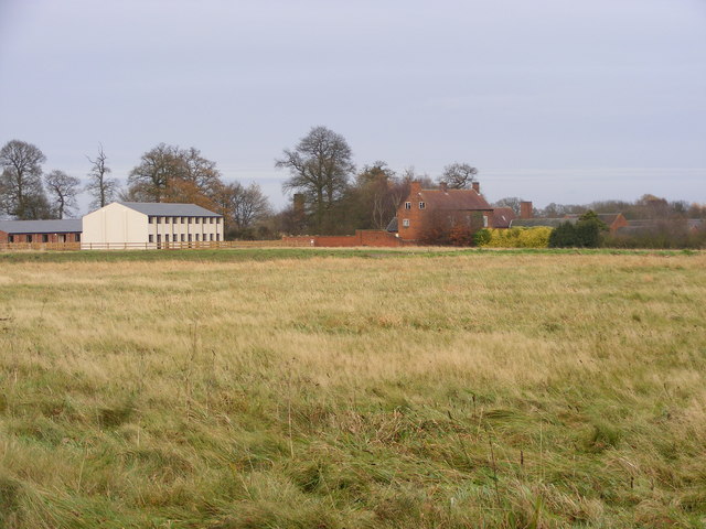
Middle Wood is a picturesque forest located in Staffordshire, England. Spanning an area of approximately 200 acres, it is nestled in the heart of the county and is a popular destination for nature lovers and outdoor enthusiasts.

The woodland is predominantly composed of mixed deciduous trees, including oak, ash, beech, and birch, which create a diverse and enchanting landscape. The forest floor is covered with a carpet of bluebells and wildflowers during the spring months, adding to the area's natural beauty.

Middle Wood is home to a wide variety of wildlife species, including deer, foxes, badgers, and numerous bird species. It provides a rich habitat for these animals, offering ample food and shelter.

The wood is crisscrossed with a network of well-maintained footpaths and trails, making it a perfect location for walking, hiking, and cycling. These paths offer visitors the opportunity to explore the forest and take in its scenic views, including a tranquil pond and a small stream that meanders through the woodland.

For those who enjoy camping and outdoor activities, Middle Wood offers designated camping areas equipped with basic facilities. This makes it a great place for families and groups to spend a night under the stars and experience the serenity of nature.

Middle Wood is easily accessible, located just a short drive from nearby villages and towns. Its idyllic setting and abundance of natural beauty make it a must-visit destination for anyone seeking tranquility and a connection with the great outdoors in Staffordshire.

If you have any feedback on the listing, please let us know in the comments section below.

Middle Wood Images

Images are sourced within 2km of 52.584823/-2.2241049 or Grid Reference SO8498. Thanks to Geograph Open Source API. All images are credited.

Disused Buildings, near Cranmoor Lodge Farm, Perton The Staffordshire Way passes these military style buildings, all disused but with roofs intact, in the corner of a large grass covered field. Apparently they are the remains of  2nd World War RAF Perton accommodation, later used to house Dutch Army barracks.

There are threats to close the footpath to enable development. The exact original use of all the buildings here can be dug out from these planning applications: <span class="nowrap"><a title="http://www.sstaffs.gov.uk/pdf/Regulatory%20Committee%2022nd%20May%202007.pdf" rel="nofollow ugc noopener" href="http://www.sstaffs.gov.uk/pdf/Regulatory%20Committee%2022nd%20May%202007.pdf">Link</a><img style="margin-left:2px;" alt="External link" title="External link - shift click to open in new window" src="https://s1.geograph.org.uk/img/external.png" width="10" height="10"/></span>

There is fascinating detail on this Dutch website (make sure you get the translated page) <span class="nowrap"><a title="http://translate.google.co.uk/translate?hl=en&sl=nl&u=http://www.prinsesirenebrigade.nl/wrottesleypark_nabij_wolverhampt.htm&ei=rQ-5SdSoHqKHjAfAmOCwCA&sa=X&oi=translate&resnum=1&ct=result&prev=/search%3Fq%3DCranmore%2BLodge%2Bfarm%2Bperton%26hl%3Den%26client%3Dfirefox-a%26rls%3Dorg.mozilla:en-GB:official%26hs%3DI25%26sa%3DN%26start%3D10" rel="nofollow ugc noopener" href="http://translate.google.co.uk/translate?hl=en&sl=nl&u=http://www.prinsesirenebrigade.nl/wrottesleypark_nabij_wolverhampt.htm&ei=rQ-5SdSoHqKHjAfAmOCwCA&sa=X&oi=translate&resnum=1&ct=result&prev=/search%3Fq%3DCranmore%2BLodge%2Bfarm%2Bperton%26hl%3Den%26client%3Dfirefox-a%26rls%3Dorg.mozilla:en-GB:official%26hs%3DI25%26sa%3DN%26start%3D10">Link</a><img style="margin-left:2px;" alt="External link" title="External link - shift click to open in new window" src="https://s1.geograph.org.uk/img/external.png" width="10" height="10"/></span>
Disused Buildings, near Cranmoor Lodge Farm, Perton
The Staffordshire Way passes these military style buildings, all disused but with roofs intact, in the corner of a large grass covered field. Apparently they are the remains of 2nd World War RAF Perton accommodation, later used to house Dutch Army barracks. There are threats to close the footpath to enable development. The exact original use of all the buildings here can be dug out from these planning applications: LinkExternal link There is fascinating detail on this Dutch website (make sure you get the translated page) LinkExternal link
Disused Buildings near Cranmoor Lodge Farm, Perton The Staffordshire Way passes these military style buildings, all disused but with roofs intact, in the corner of a large grass covered field. Apparently they are the remains of  2nd World War RAF Perton accommodation, later used as a Dutch Army barracks.

There are threats to close the footpath to enable development. The exact original use of all the buildings here can be dug out from these planning applications: <span class="nowrap"><a title="http://www.sstaffs.gov.uk/pdf/Regulatory%20Committee%2022nd%20May%202007.pdf" rel="nofollow ugc noopener" href="http://www.sstaffs.gov.uk/pdf/Regulatory%20Committee%2022nd%20May%202007.pdf">Link</a><img style="margin-left:2px;" alt="External link" title="External link - shift click to open in new window" src="https://s1.geograph.org.uk/img/external.png" width="10" height="10"/></span>

There is fascinating detail on this Dutch website (make sure you get the translated page) <span class="nowrap"><a title="http://translate.google.co.uk/translate?hl=en&sl=nl&u=http://www.prinsesirenebrigade.nl/wrottesleypark_nabij_wolverhampt.htm&ei=rQ-5SdSoHqKHjAfAmOCwCA&sa=X&oi=translate&resnum=1&ct=result&prev=/search%3Fq%3DCranmore%2BLodge%2Bfarm%2Bperton%26hl%3Den%26client%3Dfirefox-a%26rls%3Dorg.mozilla:en-GB:official%26hs%3DI25%26sa%3DN%26start%3D10" rel="nofollow ugc noopener" href="http://translate.google.co.uk/translate?hl=en&sl=nl&u=http://www.prinsesirenebrigade.nl/wrottesleypark_nabij_wolverhampt.htm&ei=rQ-5SdSoHqKHjAfAmOCwCA&sa=X&oi=translate&resnum=1&ct=result&prev=/search%3Fq%3DCranmore%2BLodge%2Bfarm%2Bperton%26hl%3Den%26client%3Dfirefox-a%26rls%3Dorg.mozilla:en-GB:official%26hs%3DI25%26sa%3DN%26start%3D10">Link</a><img style="margin-left:2px;" alt="External link" title="External link - shift click to open in new window" src="https://s1.geograph.org.uk/img/external.png" width="10" height="10"/></span>
Disused Buildings near Cranmoor Lodge Farm, Perton
The Staffordshire Way passes these military style buildings, all disused but with roofs intact, in the corner of a large grass covered field. Apparently they are the remains of 2nd World War RAF Perton accommodation, later used as a Dutch Army barracks. There are threats to close the footpath to enable development. The exact original use of all the buildings here can be dug out from these planning applications: LinkExternal link There is fascinating detail on this Dutch website (make sure you get the translated page) LinkExternal link
Cranmoor Lodge Farm The Staffordshire and Monarch's Ways pass by the Farm.
Cranmoor Lodge Farm
The Staffordshire and Monarch's Ways pass by the Farm.
Prefabricated barn on Cranmoor Lodge Farm road The barn is a survivor from the days of RAF Perton, a WWII airbase and relief landing ground. It was used to train navigators and bomb-aimers, who would be suspended in a cradle from the roof beams, and expected to familiarise themselves with a scrolling map of the part of Germany that their next mission would be taking them to. It stands by the side of a track between the former airfield (now entirely obliterated by Perton housing estate) and the various dispersal sites, quarters, training areas etc around the lands of Cranmoor Lodge Farm.
Prefabricated barn on Cranmoor Lodge Farm road
The barn is a survivor from the days of RAF Perton, a WWII airbase and relief landing ground. It was used to train navigators and bomb-aimers, who would be suspended in a cradle from the roof beams, and expected to familiarise themselves with a scrolling map of the part of Germany that their next mission would be taking them to. It stands by the side of a track between the former airfield (now entirely obliterated by Perton housing estate) and the various dispersal sites, quarters, training areas etc around the lands of Cranmoor Lodge Farm.
Farm road across Cranmoor (1) Cranmoor = Crane Moor = a place where common cranes used to live. They're no longer common, in fact they're as good as extinct in the UK, although the RSPB is beginning a project to reintroduce them in a select few locations. I rather suspect the outskirts of Wolverhampton will not be one of those locations, especially as the land is now given over to wheat and potato fields.
Farm road across Cranmoor (1)
Cranmoor = Crane Moor = a place where common cranes used to live. They're no longer common, in fact they're as good as extinct in the UK, although the RSPB is beginning a project to reintroduce them in a select few locations. I rather suspect the outskirts of Wolverhampton will not be one of those locations, especially as the land is now given over to wheat and potato fields.
Farm road across Cranmoor (2) Another view along the farm track across the 'crane moor', with a new plantation of spruce on the right.
Farm road across Cranmoor (2)
Another view along the farm track across the 'crane moor', with a new plantation of spruce on the right.
Building works at Cranmoor Lodge Farm New buildings and conversion work are going on at the farm. Whilst that happens, the footpath through the farmyard has been formally closed, so it's hard to get a real idea of just what's going on.
Building works at Cranmoor Lodge Farm
New buildings and conversion work are going on at the farm. Whilst that happens, the footpath through the farmyard has been formally closed, so it's hard to get a real idea of just what's going on.
Field Path The Staffordshire Way and the Monarch's Way from the Pattingham Road crosses a field near Perton.
Field Path
The Staffordshire Way and the Monarch's Way from the Pattingham Road crosses a field near Perton.
Ways Path The Staffordshire Way and the Monarch's Way pass near Cranmoor Lodge.
Ways Path
The Staffordshire Way and the Monarch's Way pass near Cranmoor Lodge.
Cranmoor lodge The  view from the Staffordshire Way and the Monarch's Way pass near Cranmoor Lodge. The old RAF buildings are being converted to housing.<a href="https://www.geograph.org.uk/photo/384570">SJ8500 : Disused Buildings near Cranmoor Lodge Farm, Perton</a>
Cranmoor lodge
The view from the Staffordshire Way and the Monarch's Way pass near Cranmoor Lodge. The old RAF buildings are being converted to housing.SJ8500 : Disused Buildings near Cranmoor Lodge Farm, Perton
Path through Cranmoor Lodge The view from the Staffordshire Way and the Monarch's Way.
Path through Cranmoor Lodge
The view from the Staffordshire Way and the Monarch's Way.
Interpretation board: RAF Perton (Cranmore Lodge) This very informative board gives a brief history of RAF Perton <span class="nowrap"><a title="http://www.pertonvillage.co.uk/Airfields.htm" rel="nofollow ugc noopener" href="http://www.pertonvillage.co.uk/Airfields.htm">Link</a><img style="margin-left:2px;" alt="External link" title="External link - shift click to open in new window" src="https://s1.geograph.org.uk/img/external.png" width="10" height="10"/></span>. The board is just out of shot in
<a href="https://www.geograph.org.uk/photo/1618661">SJ8500 : Path through Cranmoor Lodge</a> but the same guide post is visible in both!
Interpretation board: RAF Perton (Cranmore Lodge)
This very informative board gives a brief history of RAF Perton LinkExternal link. The board is just out of shot in SJ8500 : Path through Cranmoor Lodge but the same guide post is visible in both!
Cranmore Lodge Farm, Perton, W of Wolverhampton
Cranmoor Wood The view from the Staffordshire Way and the Monarch's Way footpaths near Perton.
Cranmoor Wood
The view from the Staffordshire Way and the Monarch's Way footpaths near Perton.
Run to Perton The view from the Staffordshire Way and the Monarch's Way footpaths of the track to Perton.
Run to Perton
The view from the Staffordshire Way and the Monarch's Way footpaths of the track to Perton.
Cranmoor View The view from the Staffordshire Way and the Monarch's Way towards Cranmoor Lodge, Perton.
Cranmoor View
The view from the Staffordshire Way and the Monarch's Way towards Cranmoor Lodge, Perton.
Saint Andrews Drive The view from by Lower Lake Perton off The Parkway road.
Saint Andrews Drive
The view from by Lower Lake Perton off The Parkway road.
Wentworth Grove The view in Perton, Staffordshire.
Wentworth Grove
The view in Perton, Staffordshire.
Show me another place!

Middle Wood is located at Grid Ref: SO8498 (Lat: 52.584823, Lng: -2.2241049)

Administrative County: Staffordshire

District: South Staffordshire

Police Authority: Staffordshire

What 3 Words

///stored.beast.types. Near Pattingham, Staffordshire

Related Wikis

Nurton

Nurton is a hamlet in the South Staffordshire District, in the English county of Staffordshire. Nearby settlements include the city of Wolverhampton and...

Perton

Perton is a large village and civil parish located in the South Staffordshire District, Staffordshire, England. It lies 3 miles to the south of Codsall...

Wightwick

Wightwick ( WIT-ik) is a part of Tettenhall Wightwick ward in Wolverhampton, West Midlands, England. It is named after an ancient local family the "de...
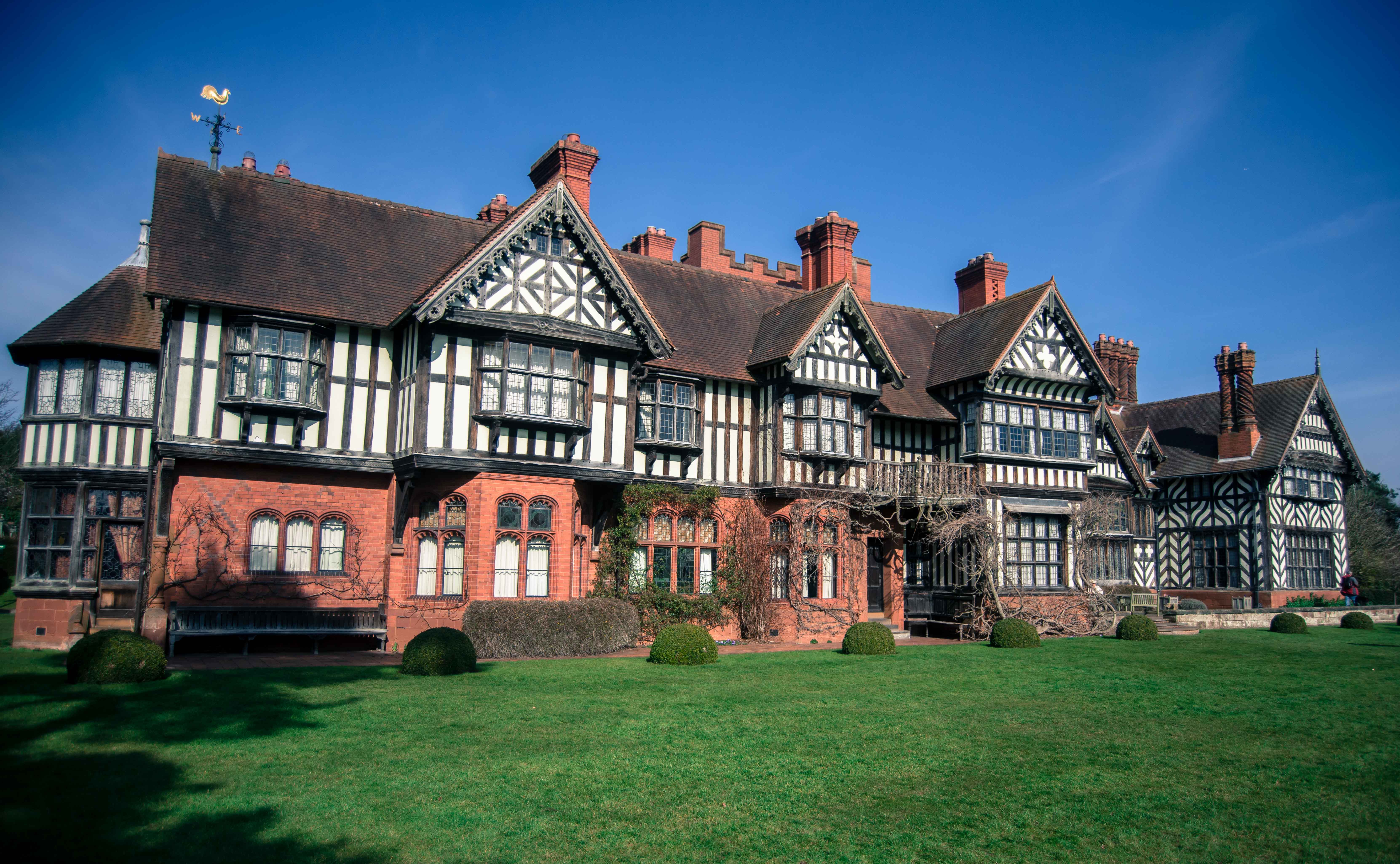
Wightwick Manor

The legacy of a family's passion for Victorian art and design, Wightwick Manor (pronounced "Wittick") is a Victorian manor house located on Wightwick Bank...

A.F.C. Wulfrunians

A.F.C. Wulfrunians is a football club based in Castlecroft, Wolverhampton, England. They are currently members of the Midland League Premier Division and...

Smestow Academy

Smestow Academy (formerly Smestow School), also known as simply Smestow (pronounced "smest-oh") is a coeducational secondary school and sixth form located...

Pattingham

Pattingham is a village and former civil parish, now in the parish of Pattingham and Patshull, in the South Staffordshire district, in the county of Staffordshire...

Tettenhall Wightwick (ward)

Tettenhall Wightwick is a ward of Wolverhampton City Council, West Midlands. The population of this ward taken at the 2011 census was 10,872. == Geography... ==

Have you been to Middle Wood?

Leave your review of Middle Wood below (or comments, questions and feedback).