Target Wood

Wood, Forest in Staffordshire Newcastle-under-Lyme

England

Target Wood

Harecastle Tunnel, south end, 1984 Fitted with ventilation doors, extractor fans and height gauge.
Harecastle Tunnel, south end, 1984 Credit: Robin Webster

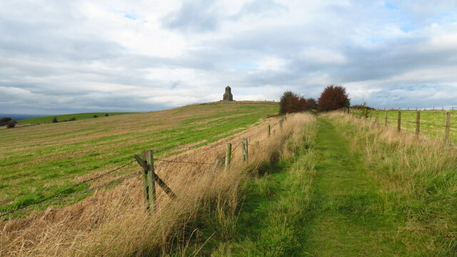
Target Wood is a picturesque forest located in the county of Staffordshire, England. It covers an area of approximately 100 acres and is renowned for its natural beauty and diverse wildlife. Situated in the heart of the countryside, Target Wood offers visitors a tranquil escape from the bustling city life.

The woodland is primarily composed of deciduous trees, such as oak, birch, and beech, creating a rich and vibrant canopy. The forest floor is carpeted with a variety of plants and wildflowers, adding to its enchanting atmosphere. The tall and majestic trees provide ample shade during the summer months, making it an ideal spot for picnics and leisurely walks.

Target Wood is not only a haven for nature enthusiasts but also a thriving habitat for a wide range of wildlife. Visitors may spot various bird species, including woodpeckers, owls, and thrushes, as well as small mammals like foxes, squirrels, and rabbits. The woodland is also home to a diverse array of insects, reptiles, and amphibians, making it a haven for nature lovers and wildlife photographers.

The forest is equipped with well-marked trails, allowing visitors to explore its beauty at their own pace. These paths offer stunning views of the surrounding countryside and lead to a small lake, where visitors can enjoy fishing or simply take in the serene ambiance.

Target Wood is a popular destination for families, couples, and individuals seeking a peaceful retreat amidst nature. Whether it's a leisurely stroll, a bird-watching expedition, or a picnic with loved ones, this woodland provides a refreshing and rejuvenating experience for all who visit.

If you have any feedback on the listing, please let us know in the comments section below.

Target Wood Images

Images are sourced within 2km of 53.066474/-2.248746 or Grid Reference SJ8352. Thanks to Geograph Open Source API. All images are credited.

Harecastle Tunnel, south end, 1984 Fitted with ventilation doors, extractor fans and height gauge.
Harecastle Tunnel, south end, 1984
Fitted with ventilation doors, extractor fans and height gauge.
Harecastle Tunnel south portal, Stoke-on-Trent On the Trent and Mersey Canal, this is the south portal of the tunnel built by Thomas Telford in 1827 to augment and by the mid twentieth century replace the earlier 1777 tunnel (off to the left) of James Brindley.
The tunnel is just under two miles long (2926 yards, 2675 metres). Most crews take 30-40 minutes to navigate through to Kidsgrove. There was originally a towpath, but this was removed in the mid 1970s due to subsidence.

Jo Turner adds:
Harecastle Tunnel south portal, Stoke-on-Trent
On the Trent and Mersey Canal, this is the south portal of the tunnel built by Thomas Telford in 1827 to augment and by the mid twentieth century replace the earlier 1777 tunnel (off to the left) of James Brindley. The tunnel is just under two miles long (2926 yards, 2675 metres). Most crews take 30-40 minutes to navigate through to Kidsgrove. There was originally a towpath, but this was removed in the mid 1970s due to subsidence. Jo Turner adds:
Path leading north towards the Wedgwood Monument on Bignall Hill The large stone monument on the summit which is dedicated to John Wedgwood (1760–1839), a former local employer and coal mine owner. Wedgwood's monument was initially an obelisk erected in 1850. Following storm damage in 1976 it was reduced to a quarter of its original size, although the base is still substantial. The monument is a Grade II listed building.(source Wikipedia)
Path leading north towards the Wedgwood Monument on Bignall Hill
The large stone monument on the summit which is dedicated to John Wedgwood (1760–1839), a former local employer and coal mine owner. Wedgwood's monument was initially an obelisk erected in 1850. Following storm damage in 1976 it was reduced to a quarter of its original size, although the base is still substantial. The monument is a Grade II listed building.(source Wikipedia)
Trig Point on Bignall Hill near Talke
Bathpool Dam and Dry Ski Slope
Trainline, Bathpool
Trainline, Bathpool
Newcastle Way, Bignall Hill reservoir
Ungrazed lime A lime tree in a field which has not been grazed for many years. The branches are touching the ground.
Ungrazed lime
A lime tree in a field which has not been grazed for many years. The branches are touching the ground.
JCB logistics Massive and imaginatively designed building seen from Ashenough Hill.
JCB logistics
Massive and imaginatively designed building seen from Ashenough Hill.
Newcastle Road The A34
Newcastle Road
The A34
Peacock Hay Road
Peacock Hay Road
Slopes above Peacock Hay Road
Peacock Hay Road Looking towards the JCB World Logistics building.
Peacock Hay Road
Looking towards the JCB World Logistics building.
Newfield Hollywall Road
Newfield
Hollywall Road
Urban edge, Newfield
Hollywall Road
Hollywall Road
Reservoirs, Gill Bank
Gill Bank Road Passing between covered reservoirs.
Gill Bank Road
Passing between covered reservoirs.
Show me another place!

Target Wood is located at Grid Ref: SJ8352 (Lat: 53.066474, Lng: -2.248746)

Administrative County: Staffordshire

District: Newcastle-under-Lyme

Police Authority: Staffordshire

What 3 Words

///comb.fork.beside. Near Kidsgrove, Staffordshire

Nearby Locations

Target Wood

Related Wikis

Talke Pits

Talke Pits is a former mining village in the Borough of Newcastle-under-Lyme, Staffordshire, England, close to the Cheshire border and the village of Talke...

Harecastle railway tunnel

The Harecastle railway tunnels are three consecutive tunnels on the North Staffordshire Railway at Kidsgrove, Staffordshire, England. Opened to traffic...

Harecastle Tunnel

Harecastle Tunnel is a canal tunnel on the Trent and Mersey Canal in Staffordshire between Kidsgrove and Tunstall. The tunnel, which is 1.6 mi (2.6 km...

Talke (ward)

Talke was a ward in the Borough of Newcastle-under-Lyme. It covered the villages of Talke and Talke Pits. As of the 2018 Newcastle-under-Lyme Borough Council...

Red Street

Red Street is a small, semi-rural village in the borough of Newcastle-under-Lyme, Staffordshire 6 miles (9.7 km) north west of Stoke-on-Trent, 2 miles...

Bathpool Park

Bathpool Park is a public park in a rural area between Newcastle-under-Lyme and Kidsgrove, Staffordshire (near the border with Cheshire). The park became...

Chatterley railway station

Chatterley railway station is a former railway station in Staffordshire, England. Situated in the main North Staffordshire Railway (NSR) between Stoke...

Talke

Talke is a village in the civil parish of Kidsgrove, in the Newcastle-under-Lyme district, in Staffordshire, England. It is 4 miles (6.4 km) northwest...

Nearby Amenities

Located within 500m of 53.066474,-2.248746
Traffic Signals
Traffic Signals: signal
Lat/Long: 53.0623739/-2.2505964
Bus Stop
Oaktree Lane
Bench: no
Bin: yes
Bus: yes
Naptan AtcoCode: 3800C508000
Naptan Bearing: N
Naptan CommonName: Oaktree Lane
Naptan Indicator: Adj
Naptan Landmark: adj Oaktree Lane
Naptan PlusbusZoneRef: STOKEOT
Naptan Street: High Street
Naptan Verified: no
Public Transport: platform
Ref: stadtagj
Shelter: no
Source: naptan_import
Lat/Long: 53.0665074/-2.2556215
Bus Stop
Arbour Street
Bench: no
Bin: no
Bus: yes
Naptan AtcoCode: 3800C508001
Naptan Bearing: S
Naptan CommonName: Arbour Street
Naptan Indicator: Opp
Naptan Landmark: Arbour Street
Naptan PlusbusZoneRef: STOKEOT
Naptan Street: High Street
Naptan Verified: no
Public Transport: platform
Ref: stadtagm
Shelter: no
Source: naptan_import
Lat/Long: 53.0666969/-2.2555869
Bus Stop
Harecastle Farm
Bus: yes
Naptan AtcoCode: 3800C511301
Naptan Bearing: S
Naptan CommonName: Harecastle Farm
Naptan Indicator: Adj
Naptan Landmark: Harecastle Farm
Naptan PlusbusZoneRef: STOKEOT
Naptan Street: Newcastle Rd
Naptan Verified: no
Public Transport: platform
Source: naptan_import
Lat/Long: 53.0690922/-2.252376
Bus Stop
Harecastle Farm
Bus: yes
Naptan AtcoCode: 3800C511302
Naptan Bearing: N
Naptan BusStopType: CUS
Naptan CommonName: Harecastle Farm
Naptan Indicator: Opp
Naptan Landmark: Harecastle Farm
Naptan PlusbusZoneRef: STOKEOT
Naptan Street: Newcatle Rd
Naptan Verified: no
Public Transport: platform
Source: naptan_import
Lat/Long: 53.0690289/-2.2525547
Talke Pits
Is In: newcastle under lyme
Place: locality
Wikidata: Q7679736
Lat/Long: 53.0669757/-2.2548273
Peacock Hay
Is In: newcastle under lyme
Place: locality
Lat/Long: 53.0637651/-2.2466304
Note: colour light signal
Railway: signal
Lat/Long: 53.069002/-2.2428281
Power: tower
Lat/Long: 53.0648767/-2.2484954
Power: tower
Lat/Long: 53.0651476/-2.2429509
Power: tower
Lat/Long: 53.0646148/-2.2539906
Restaurant
Harecastle Farm
Cuisine: steak_house
Lat/Long: 53.0684775/-2.2512529
Crossing
Crossing Island: yes
Lat/Long: 53.0648579/-2.2526746
Traffic Signals
Traffic Signals: signal
Lat/Long: 53.0633573/-2.2528562
Traffic Signals
Traffic Signals: signal
Lat/Long: 53.0634029/-2.2530208
Barrier: stile
Lat/Long: 53.0649255/-2.2525064
Traffic Signals
Traffic Signals: signal
Lat/Long: 53.0624234/-2.2508
Bench
Backrest: no
Lit: no
Lat/Long: 53.0676711/-2.242553
Power: pole
Lat/Long: 53.0706553/-2.2504855
Power: pole
Lat/Long: 53.0695429/-2.2514515
Power: pole
Lat/Long: 53.0703648/-2.2513817
Power: pole
Lat/Long: 53.0687629/-2.2515024
Power: pole
Lat/Long: 53.0651842/-2.2501452
Power: pole
Lat/Long: 53.0652965/-2.2486928
Power: pole
Lat/Long: 53.0654607/-2.2460846
Power: pole
Lat/Long: 53.0648435/-2.2528571
Power: pole
Lat/Long: 53.0644957/-2.253394
Street Lamp
Lat/Long: 53.0648545/-2.2525461
Power: pole
Lat/Long: 53.0650393/-2.2516828
Communication Mobile Phone: yes
Man Made: mast
Tower Type: communication
Lat/Long: 53.064335/-2.2530607
Fast Food
Greggs
Brand: Greggs
Brand Wikidata: Q3403981
Brand Wikipedia: en:Greggs
Contact Website: https://www.greggs.co.uk/shop-finder?shop-code=5330
Cuisine: sandwich;bakery
Takeaway: yes
Lat/Long: 53.0640256/-2.2529581
Fast Food
Subway
Brand: Subway
Brand Wikidata: Q244457
Brand Wikipedia: en:Subway (restaurant)
Contact Website: https://restaurants.subway.com/united-kingdom/en/stoke-on-trent/newcastle-road-talke-pit
Cuisine: sandwich
Takeaway: yes
Lat/Long: 53.0640351/-2.2530023
Sainsbury's On The Go
Brand: Sainsbury's On the Go
Brand Wikidata: Q106860528
Shop: convenience
Lat/Long: 53.0640745/-2.2529227
Power: pole
Lat/Long: 53.0637106/-2.2541663
Power: pole
Lat/Long: 53.0643988/-2.2534999
Power: pole
Lat/Long: 53.0660598/-2.2458231
Power: pole
Lat/Long: 53.0647156/-2.2463671
Power: pole
Lat/Long: 53.0637951/-2.2467477
Power: pole
Lat/Long: 53.063116/-2.2470303
Communication Mobile Phone: yes
Man Made: mast
Tower Type: communication
Lat/Long: 53.0632619/-2.2471213
Power: pole
Lat/Long: 53.0629059/-2.2462516
Power: pole
Lat/Long: 53.0627059/-2.2455337
Power: pole
Lat/Long: 53.0659034/-2.2480817
Power: pole
Lat/Long: 53.0669013/-2.2472492
Power: pole
Lat/Long: 53.0671373/-2.2479429
Power: pole
Lat/Long: 53.0666748/-2.2470457
The data included in this document is from www.openstreetmap.org. The data is made available under ODbL.

Have you been to Target Wood?

Leave your review of Target Wood below (or comments, questions and feedback).