Winnall Coppice

Wood, Forest in Worcestershire Wychavon

England

Winnall Coppice

Looking southwest from the B4196 in 1987
Looking southwest from the B4196 in 1987 Credit: John Baker

Winnall Coppice is a picturesque woodland located in the county of Worcestershire, England. Covering an area of approximately 200 acres, this ancient forest is a haven for nature enthusiasts and those seeking tranquility in a natural setting.

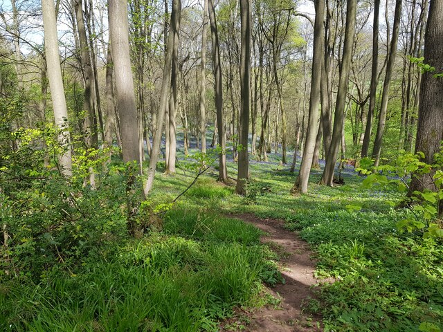
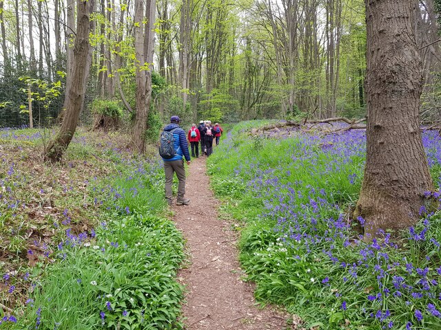
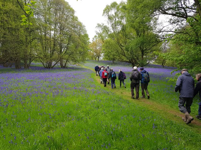
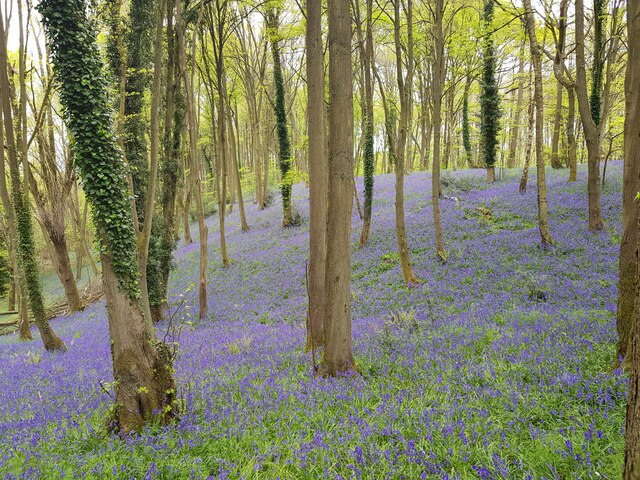
The coppice is primarily composed of oak, ash, and birch trees, with a diverse range of flora and fauna thriving within its boundaries. The woodland floor is adorned with a carpet of bluebells during the spring, creating a breathtaking display of vibrant colors. Various species of wildflowers, such as primroses and foxgloves, also add to the beauty of the forest.

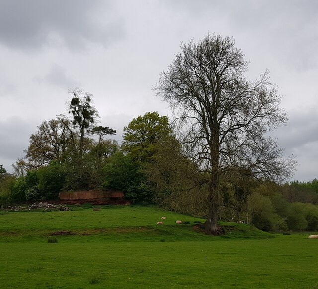
Winnall Coppice is home to a variety of wildlife, including deer, badgers, and numerous bird species. Birdwatchers can spot woodpeckers, tawny owls, and a multitude of songbirds flitting among the branches. The forest also provides a habitat for rare and endangered species, such as the silver-washed fritillary butterfly.

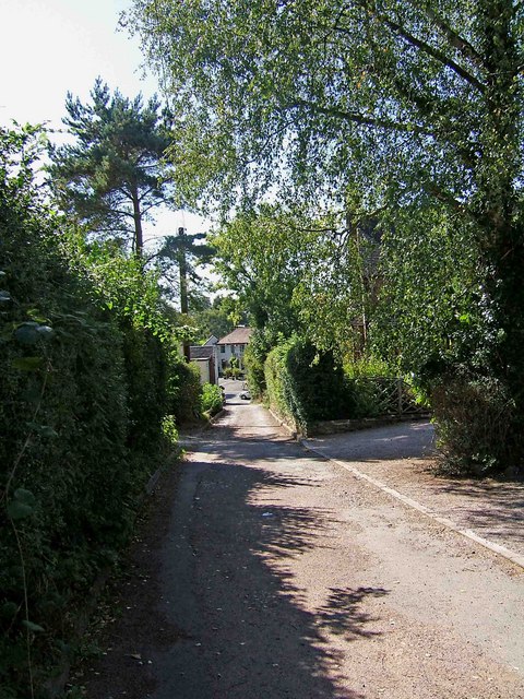
Visitors can explore the woodland through well-maintained walking trails that wind their way through the trees. The paths offer breathtaking views of the surrounding countryside and provide opportunities for peaceful picnics or leisurely walks with family and friends. Wildlife enthusiasts can enjoy observing and photographing the diverse flora and fauna.

Winnall Coppice is a popular destination for outdoor activities, including nature walks, birdwatching, and photography. The forest's serene atmosphere and natural beauty make it a must-visit location for those seeking a peaceful escape from the hustle and bustle of everyday life.

If you have any feedback on the listing, please let us know in the comments section below.

Winnall Coppice Images

Images are sourced within 2km of 52.303857/-2.2716505 or Grid Reference SO8167. Thanks to Geograph Open Source API. All images are credited.

Looking southwest from the B4196 in 1987
Glazen Bridge On the turnpike from Bewdley to Worcester and rebuilt by the county council in 1925 with an iron balustrade.Not a particularly distinguished bridge (in my opinion) but selected for a mention in Fred Brook, The Industrial Archaeology of the British Isles, 1 West Midlands (1977). This crosses the Dick Brook.
Glazen Bridge
On the turnpike from Bewdley to Worcester and rebuilt by the county council in 1925 with an iron balustrade.Not a particularly distinguished bridge (in my opinion) but selected for a mention in Fred Brook, The Industrial Archaeology of the British Isles, 1 West Midlands (1977). This crosses the Dick Brook.
Gateway to the dream of country living Off B4196, near the New Inn, Noutard's Green, Worcestershire
Gateway to the dream of country living
Off B4196, near the New Inn, Noutard's Green, Worcestershire
The New Inn, Shrawley The New Inn in Shrawley is situated on the B4196.
The New Inn, Shrawley
The New Inn in Shrawley is situated on the B4196.
The New Inn, Shrawley Shrawley is a long straggling village, with much of it fronting the B4196 Stourport-on-Severn to Holt Heath road. The village has two public houses, of which this is one. It is a free house. <a href="https://www.geograph.org.uk/photo/1484770">SO7966 : The New Inn pub sign, Shrawley</a>
The New Inn, Shrawley
Shrawley is a long straggling village, with much of it fronting the B4196 Stourport-on-Severn to Holt Heath road. The village has two public houses, of which this is one. It is a free house. SO7966 : The New Inn pub sign, Shrawley
The New Inn pub sign, Shrawley In the middle of the sign is a picture of the pub, but it is so badly faded that it has been impossible to bring up any detail in the photograph. On the right is the B4196 road, looking in the direction of Stourport-on-Severn. <a href="https://www.geograph.org.uk/photo/1484755">SO7966 : The New Inn, Shrawley</a>
The New Inn pub sign, Shrawley
In the middle of the sign is a picture of the pub, but it is so badly faded that it has been impossible to bring up any detail in the photograph. On the right is the B4196 road, looking in the direction of Stourport-on-Severn. SO7966 : The New Inn, Shrawley
Lane from Shrawley Wood to the B4196 at Shrawley This short lane leads down from the extensive Shrawley Wood to the B4196. There are several houses adjacent to the lane. In the distance can be glimpsed The New Inn. Much of the wood is public access land, and it has many footpaths crossing it. <a href="https://www.geograph.org.uk/photo/1484755">SO7966 : The New Inn, Shrawley</a>.
Lane from Shrawley Wood to the B4196 at Shrawley
This short lane leads down from the extensive Shrawley Wood to the B4196. There are several houses adjacent to the lane. In the distance can be glimpsed The New Inn. Much of the wood is public access land, and it has many footpaths crossing it. SO7966 : The New Inn, Shrawley.
Footpath through the Bluebells, Shrawley Woods
Minor path in Shrawley woods with Bluebells and Ramsons
Horse on a wall A garden ornament on way to Shrawley Woods.
Horse on a wall
A garden ornament on way to Shrawley Woods.
Oliver's Mound, Shrawley Woods
New Pool, Shrawley Woods
Walkers in Shrawley Woods admiring the bluebells
Bluebells in Shrawley Woods
Walkers amongst the bluebells, Shrawley Wood
Slope of bluebells, Shrawley Woods
Sequoiadendron Wellingtonia At a crossroads of trails in Shrawley Woods.
Sequoiadendron Wellingtonia
At a crossroads of trails in Shrawley Woods.
Ombersley Golf Club Clubhouse (1), Bishops Wood Road, near Ombersley, Worcs The club was developed by a local farming family who continue to run it. The course opened in late 1991. The impressive Clubhouse includes a bar and restaurant which is open to the public, including those who do not play golf.  There is a large car park in front with access from Bishops Wood Road.

<a href="https://www.geograph.org.uk/photo/7436394">SO8267 : Ombersley Golf Club Clubhouse (2), Bishops Wood Road, near Ombersley, Worcs</a>.
Ombersley Golf Club Clubhouse (1), Bishops Wood Road, near Ombersley, Worcs
The club was developed by a local farming family who continue to run it. The course opened in late 1991. The impressive Clubhouse includes a bar and restaurant which is open to the public, including those who do not play golf. There is a large car park in front with access from Bishops Wood Road. SO8267 : Ombersley Golf Club Clubhouse (2), Bishops Wood Road, near Ombersley, Worcs.
Show me another place!

Winnall Coppice is located at Grid Ref: SO8167 (Lat: 52.303857, Lng: -2.2716505)

Administrative County: Worcestershire

District: Wychavon

Police Authority: West Mercia

What 3 Words

///radio.blotches.hazy. Near Hartlebury, Worcestershire

Nearby Locations

Winnall Winnall Coppice

Related Wikis

Dick Brook

Dick Brook is small tributary stream of the River Severn that flows through Worcestershire, England.The brook is formed from two small unnamed streams...

Astley Burf

Astley Burf is a hamlet in the parish of Astley, Worcestershire, England, on the banks of the River Severn. Within the hamlet there is one riverside public...

Astley Hall, Stourport-on-Severn

Astley Hall is a country house in Astley near Stourport-on-Severn, Worcestershire, England. The hall was the home of Prime Minister Stanley Baldwin from...

Noutard's Green

Noutard's Green is a hamlet within the civil parish of Shrawley in Worcestershire, England. == References ==

Frog Pool

Frog Pool is a hamlet within the civil parish of Shrawley in Worcestershire, England. == References ==

Pool House, Worcestershire

Pool House is a Grade II* listed house in Astley, in the county of Worcestershire, England.In the area close to Stourport-on-Severn, there are several...

Shrawley

Shrawley is a village and civil parish in the Malvern Hills District in the county of Worcestershire, England. The village is situated on the western bank...

Astley Cross

Astley Cross is a village in Worcestershire, England, located on the outskirts of Stourport-on-Severn. The village lies 1 mile (1.6 km) south of the centre...

Nearby Amenities

Located within 500m of 52.303857,-2.2716505
Astley Public Loading Wharf
Man Made: quay
Lat/Long: 52.3068515/-2.2752726
Barrier: stile
Lat/Long: 52.3013791/-2.2756768
Barrier: stile
Lat/Long: 52.3006967/-2.2756231
Barrier: stile
Lat/Long: 52.30631/-2.2743367
Power: pole
Lat/Long: 52.2997335/-2.2738001
Power: pole
Lat/Long: 52.3014852/-2.2740629
Power: pole
Lat/Long: 52.3070189/-2.2725716
Power: pole
Lat/Long: 52.3061366/-2.2729364
Power: pole
Lat/Long: 52.3053067/-2.2732153
Power: pole
Lat/Long: 52.3034864/-2.2738483
Power: pole
Lat/Long: 52.3045097/-2.273521
Power: pole
Lat/Long: 52.3079274/-2.2722605
Power: pole
Lat/Long: 52.3025679/-2.2741541
Power: pole
Lat/Long: 52.3080563/-2.26946
Winnall
Power: pole
Transformer: distribution
Voltage Primary: 11000
Lat/Long: 52.3080576/-2.2702029
Winnall Caravan Park
Power: transformer
Transformer: distribution
Voltage Primary: 11000
Lat/Long: 52.3069822/-2.2711216
Location Transition: yes
Power: pole
Lat/Long: 52.3079284/-2.2718927
Power: pole
Lat/Long: 52.3081625/-2.2727289
Severn Meadow
Power: pole
Transformer: distribution
Voltage Primary: 11000
Lat/Long: 52.3068214/-2.2763962
Power: pole
Lat/Long: 52.3069936/-2.2763345
Winnall
Place: hamlet
Lat/Long: 52.3074472/-2.2695541
The data included in this document is from www.openstreetmap.org. The data is made available under ODbL.

Have you been to Winnall Coppice?

Leave your review of Winnall Coppice below (or comments, questions and feedback).