Nan Nook Wood

Wood, Forest in Cheshire

England

Nan Nook Wood

Church of St Martin On Blackcarr Road and apparently not in use with services transferred to the church hall
Church of St Martin Credit: Kevin Waterhouse

Nan Nook Wood, located in Cheshire, England, is a captivating forest known for its natural beauty and rich biodiversity. Covering an area of approximately 100 acres, this enchanting wood is a popular destination for nature lovers and outdoor enthusiasts alike.

The forest is characterized by a dense canopy of towering trees, predominantly oak and beech, which provide a sheltered habitat for a diverse range of wildlife. Visitors to Nan Nook Wood can expect to encounter a variety of species, including deer, foxes, badgers, and an abundance of birdlife. The tranquil atmosphere within the wood creates a haven for birdwatchers, who may be lucky enough to spot rare species such as the lesser spotted woodpecker or the tawny owl.

The forest is crisscrossed by a network of well-maintained footpaths, allowing visitors to explore the wood at their own pace. These paths meander through sun-dappled glades and alongside babbling brooks, offering picturesque views and opportunities for peaceful walks or invigorating hikes.

Nan Nook Wood is also home to a diverse array of plant life, including wildflowers, ferns, and mosses. During the spring and summer months, the forest comes alive with vibrant colors as bluebells, primroses, and wild garlic carpet the woodland floor.

The wood is easily accessible, with a car park nearby and regular public transport links. Whether it is a leisurely stroll, a family picnic, or a wildlife-spotting adventure, Nan Nook Wood provides a serene and captivating natural setting for all who visit.

If you have any feedback on the listing, please let us know in the comments section below.

Nan Nook Wood Images

Images are sourced within 2km of 53.406572/-2.2899273 or Grid Reference SJ8090. Thanks to Geograph Open Source API. All images are credited.

Church of St Martin On Blackcarr Road and apparently not in use with services transferred to the church hall
Church of St Martin
On Blackcarr Road and apparently not in use with services transferred to the church hall
Railway view towards Stockport From the bridge on Hall Lane across the Altrincham to Stockport line
Railway view towards Stockport
From the bridge on Hall Lane across the Altrincham to Stockport line
Fun bikes on running track The large fenced track in Wythenshawe Park
Fun bikes on running track
The large fenced track in Wythenshawe Park
Southmoor House, Southmoor Road, Manchester A 1930s block fronting Southmoor Industrial Estate. There is a further block to the right, Trafford House, and extensive sheds behind.
The tram runs in front.
Southmoor House, Southmoor Road, Manchester
A 1930s block fronting Southmoor Industrial Estate. There is a further block to the right, Trafford House, and extensive sheds behind. The tram runs in front.
Offices, Southmoor Road, Manchester Post-war, possibly counting as part of the Southmoor Industrial Estate.
Since pulled down and replaced by a Lidl supermarket.
Offices, Southmoor Road, Manchester
Post-war, possibly counting as part of the Southmoor Industrial Estate. Since pulled down and replaced by a Lidl supermarket.
Moorcot Court, Bideford Drive, Manchester A nine-storey slab containing 73 flats which was probably built in the late 1960s.
Moorcot Court, Bideford Drive, Manchester
A nine-storey slab containing 73 flats which was probably built in the late 1960s.
Brookway Court, Bideford Drive, Manchester A 17-storey point block containing 94 flats which was built c1967.
Brookway Court, Bideford Drive, Manchester
A 17-storey point block containing 94 flats which was built c1967.
Southmoor, Glebelands Road, Manchester A nine-storey slab containing 73 flats which was built c1960.
Southmoor, Glebelands Road, Manchester
A nine-storey slab containing 73 flats which was built c1960.
Footbridge across Fairywell Brook For a path connecting Roundthorn Industrial Estate with residential Redbrook Road
Footbridge across Fairywell Brook
For a path connecting Roundthorn Industrial Estate with residential Redbrook Road
Metrolink tracks near Roundthorn Station The tracks are making a sharp bend to turn from the station in Southmoor Road (behind the camera) into Hollyhedge Road
Metrolink tracks near Roundthorn Station
The tracks are making a sharp bend to turn from the station in Southmoor Road (behind the camera) into Hollyhedge Road
Green Lane at Baguley Pedestrian way and bridle path leading over the railway bridge at Brooks Drive. From the roundabout at the top of Brooklands Road.
Green Lane at Baguley
Pedestrian way and bridle path leading over the railway bridge at Brooks Drive. From the roundabout at the top of Brooklands Road.
Stockport Road, Timperley, from near the Library
Wendover Road, Wythenshawe
Flats on Aimson Road West, Timperley Stockport Road is the through route in the foreground.
Flats on Aimson Road West, Timperley
Stockport Road is the through route in the foreground.
Timperley Library
Timperley Library
Baguley Station View from A5103 bridge eastward towards Stockport on former Cheshire Lines main line Glazebrook - Stockport (Tiviot Dale) - Godley Junction.  A heavy Peak Forest - Northwich (ICI Winnington) limestone train is passing, hauled by a Class 8F 2-8-0.  The station was closed in November 1964.
Baguley Station
View from A5103 bridge eastward towards Stockport on former Cheshire Lines main line Glazebrook - Stockport (Tiviot Dale) - Godley Junction. A heavy Peak Forest - Northwich (ICI Winnington) limestone train is passing, hauled by a Class 8F 2-8-0. The station was closed in November 1964.
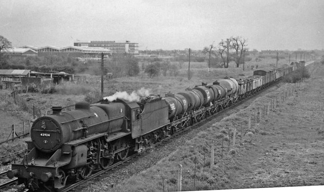
Westbound freight train approaching Baguley Station As <a href="https://www.geograph.org.uk/photo/2771994">SJ7989 : Westbound coal train at Baguley, Cheshire Lines</a>, view eastward, towards Stockport (Tiviot Dale) and Godley Junction; Cheshire Lines (CLC) main line Glazebrook - Godley Junction. The Class H freight is headed by Hughes/Fowler 5P4F 2-6-0 No. 42924. Beyond is Timpson's Shoe Works.
Westbound freight train approaching Baguley Station
As SJ7989 : Westbound coal train at Baguley, Cheshire Lines, view eastward, towards Stockport (Tiviot Dale) and Godley Junction; Cheshire Lines (CLC) main line Glazebrook - Godley Junction. The Class H freight is headed by Hughes/Fowler 5P4F 2-6-0 No. 42924. Beyond is Timpson's Shoe Works.
Car through shop window Car accident. The vehicle was driven into the window of Town and Country Carpets
Car through shop window
Car accident. The vehicle was driven into the window of Town and Country Carpets
Show me another place!

Nan Nook Wood is located at Grid Ref: SJ8090 (Lat: 53.406572, Lng: -2.2899273)

Unitary Authority: Manchester

Police Authority: Greater Manchester

What 3 Words

///full.buyers.pigs. Near Timperley, Manchester

Nearby Locations

Nan Nook Wood

Related Wikis

Wythenshawe Park tram stop

Wythenshawe Park is a tram stop for Phase 3b of the Manchester Metrolink. The station opened on 3 November 2014 and is on the Airport Line on Wythenshawe...

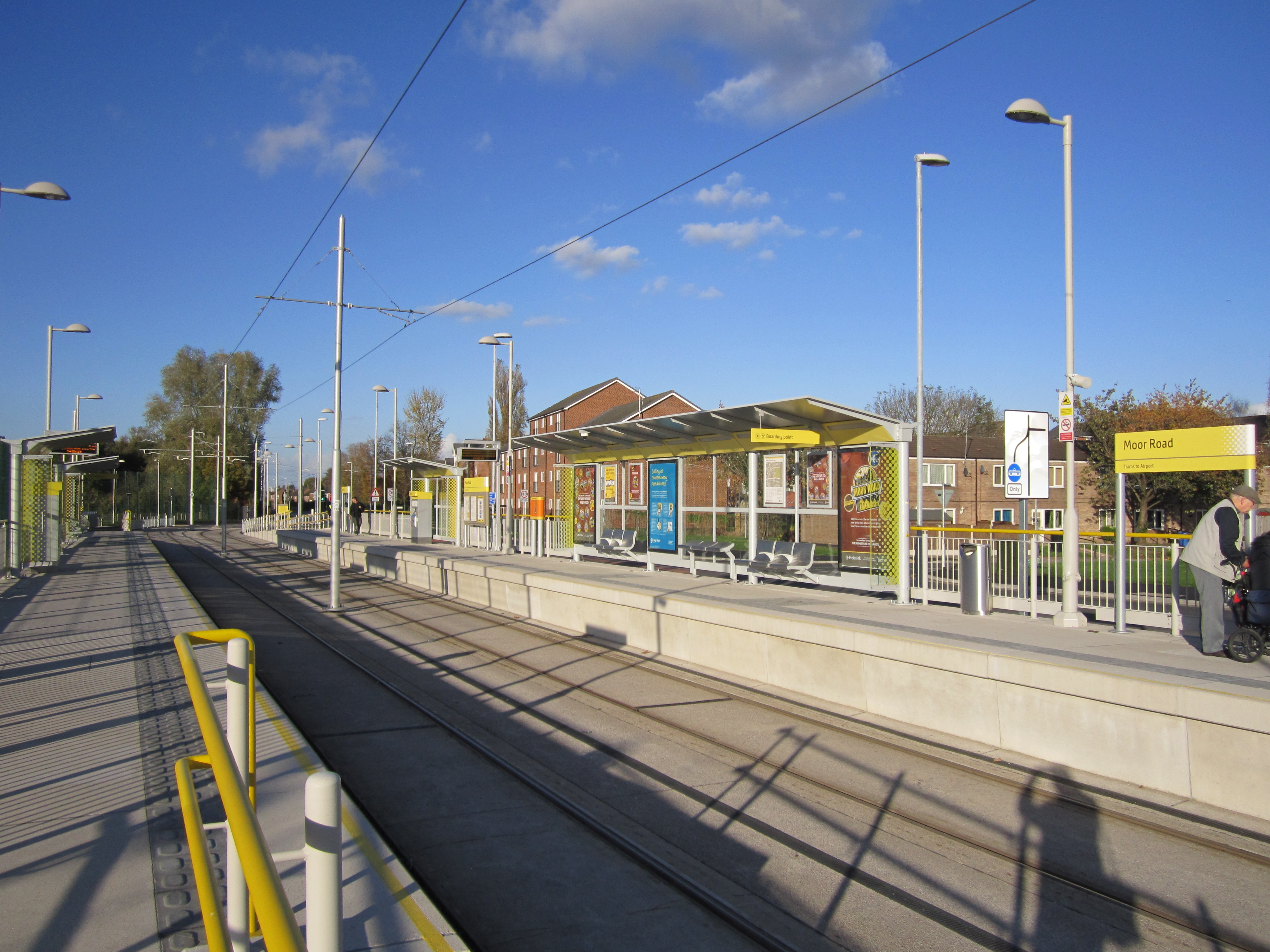
Moor Road tram stop

Moor Road is a tram stop for Phase 3b of the Manchester Metrolink. It opened on 3 November 2014. and is on the Airport Line on Moor Road at the junction...

Wythenshawe community farm

Wythenshawe Community Farm is an educational farm based in Wythenshawe Park, South Manchester. Although set in an urban environment, it operates as a working...

Dixons Brooklands Academy

Dixons Brooklands Academy, also known as DBA or DBK, is a mixed-sex secondary school in Wythenshawe, Manchester, England. == History == In 1957, two separate...

Nearby Amenities

Located within 500m of 53.406572,-2.2899273
Traffic Signals
Traffic Signals Direction: backward
Lat/Long: 53.4073082/-2.2953539
Turning Circle
Lat/Long: 53.4099108/-2.293651
Bus Stop
Northern Moor, Wythenshawe Road / near Orton Road
Bus: yes
Naptan AtcoCode: 1800SB41511
Naptan Bearing: E
Naptan CommonName: Wythenshawe Road/Orton Road
Naptan Indicator: O/S House 200
Naptan Landmark: PARK
Naptan NaptanCode: mangwjtw
Naptan PlusbusZoneRef: MNCRPIC
Naptan ShortCommonName: Orton Road
Naptan Street: Wythenshawe Road
Naptan Verified: no
Network: TfGM
Public Transport: platform
Source: naptan_import
Lat/Long: 53.4077061/-2.2826262
Bus Stop
Northern Moor, Wythenshawe Road / Wythenshawe Park Metrolink Stop (Stop D)
Bus: yes
Local Ref: D
Naptan AtcoCode: 1800SB41581
Naptan Bearing: SW
Naptan CommonName: Wythenshawe Road/Moor Road
Naptan Indicator: O/s House 247
Naptan Landmark: HOUSE 247
Naptan NaptanCode: mangwjwt
Naptan PlusbusZoneRef: MNCRPIC
Naptan ShortCommonName: Moor Road
Naptan Street: Wythenshawe Road
Naptan Verified: no
Network: TfGM
Operator: TfGM
Public Transport: platform
Ref: D
Source: naptan_import
Lat/Long: 53.4067896/-2.2973018
Bus Stop
Northern Moor, Wythenshawe Road / Wythenshawe Park Metrolink Stop (Stop E)
Bus: yes
Local Ref: E
Naptan AtcoCode: 1800SB41591
Naptan Bearing: NE
Naptan CommonName: Wythenshawe Road/Moor Road
Naptan Indicator: O/s House 396
Naptan Landmark: HOUSE 396
Naptan NaptanCode: mangwmad
Naptan PlusbusZoneRef: MNCRPIC
Naptan ShortCommonName: Moor Road
Naptan Street: Wythenshawe Road
Naptan Verified: no
Network: TfGM
Operator: TfGM
Public Transport: platform
Ref: E
Source: naptan_import
Lat/Long: 53.4069975/-2.2968519
Bus Stop
Northern Moor, Moor Road / Wythenshawe Road (Stop B)
Bus: yes
Local Ref: B
Naptan AtcoCode: 1800SB41601
Naptan Bearing: S
Naptan CommonName: Moor Road/Wythenshawe Road
Naptan Indicator: O/s House 5
Naptan Landmark: HOUSE 5
Naptan NaptanCode: mangwmag
Naptan PlusbusZoneRef: MNCRPIC
Naptan ShortCommonName: Wythenshawe Road
Naptan Street: MOOR ROAD
Naptan Verified: no
Network: TfGM
Operator: TfGM
Public Transport: platform
Ref: B
Source: naptan_import
Lat/Long: 53.4066142/-2.2955255
Bus Stop
Northern Moor, Moor Road (Stop C)
Bus: yes
Local Ref: C
Naptan AtcoCode: 1800SB41671
Naptan Bearing: N
Naptan CommonName: Moor Road/Falterley Road
Naptan Indicator: Opp House 11
Naptan Landmark: HOUSE 11
Naptan NaptanCode: mangwmap
Naptan PlusbusZoneRef: MNCRPIC
Naptan ShortCommonName: Falterley Road
Naptan Street: MOOR ROAD
Naptan Verified: no
Network: TfGM
Public Transport: platform
Source: naptan_import
Lat/Long: 53.4058384/-2.295471
Bus Stop
Moor Road/Bideford Drive
Bus: yes
Local Ref: G
Naptan AtcoCode: 1800SB41681
Naptan Bearing: N
Naptan CommonName: Moor Road/Bideford Drive
Naptan Indicator: School
Naptan Landmark: Manchester Health Academy
Naptan NaptanCode: mangwmat
Naptan PlusbusZoneRef: MNCRPIC
Naptan ShortCommonName: Bideford Drive
Naptan Street: MOOR ROAD
Naptan Verified: no
Network: TfGM
Public Transport: platform
Source: naptan_import
Lat/Long: 53.4034716/-2.2950202
Bus Stop
Northern Moor, Wythenshawe Road / Wythenshawe Park Metrolink Stop (Stop A)
Bus: yes
Local Ref: A
Naptan AtcoCode: 1800SB41711
Naptan Bearing: E
Naptan CommonName: Wythenshawe Road/Gardeners Arms
Naptan Indicator: Gardeners Arms
Naptan Landmark: GARDENERS ARMS
Naptan NaptanCode: mangwmdg
Naptan PlusbusZoneRef: MNCRPIC
Naptan ShortCommonName: Gardeners Arms
Naptan Street: Wythenshawe Road
Naptan Verified: no
Network: TfGM
Operator: TfGM
Public Transport: platform
Ref: A
Source: naptan_import
Lat/Long: 53.4075349/-2.2948804
Bus Stop
Northern Moor, Wythenshawe Road / near Northolt Road
Bus: yes
Naptan AtcoCode: 1800SB41721
Naptan Bearing: E
Naptan CommonName: Wythenshawe Road/Northolt Road
Naptan Indicator: Church
Naptan Landmark: CHURCH
Naptan NaptanCode: mangwmdj
Naptan PlusbusZoneRef: MNCRPIC
Naptan ShortCommonName: Northolt Road
Naptan Street: Wythenshawe Road
Naptan Verified: no
Network: TfGM
Public Transport: platform
Source: naptan_import
Lat/Long: 53.4080271/-2.2875174
Bus Stop
Northern Moor, Moorcroft Road / near Garthorp Road
Bus: yes
Naptan AtcoCode: 1800SB42441
Naptan Bearing: NE
Naptan CommonName: Moorcroft Road/Garthorp Road
Naptan Indicator: O/s House 188
Naptan Landmark: HOUSE 188
Naptan NaptanCode: mangwmpt
Naptan PlusbusZoneRef: MNCRPIC
Naptan ShortCommonName: Garthorp Road
Naptan Street: MOORCROFT ROAD
Naptan Verified: no
Network: TfGM
Operator: TfGM
Public Transport: platform
Source: naptan_import
Lat/Long: 53.4085602/-2.2937338
Bus Stop
Northern Moor, Moorcroft Road / outside The Park Hotel
Bus: yes
Naptan AtcoCode: 1800SB42451
Naptan Bearing: SW
Naptan CommonName: Moorcroft Road/The Park Hotel
Naptan Indicator: House 157
Naptan Landmark: HOTEL
Naptan NaptanCode: mangwmpw
Naptan Notes: INDICATOR AMENDED
Naptan PlusbusZoneRef: MNCRPIC
Naptan ShortCommonName: The Park Hotel
Naptan Street: MOORCROFT ROAD
Naptan Verified: no
Network: TfGM
Operator: TfGM
Public Transport: platform
Source: naptan_import
Lat/Long: 53.4088221/-2.2932392
Bus Stop
Northern Moor, Moorcroft Road / near Mossdale Road
Bus: yes
Naptan AtcoCode: 1800SB42461
Naptan Bearing: SW
Naptan CommonName: Moorcroft Road/Mossdale Road
Naptan Indicator: Nr House 127
Naptan Landmark: HOUSE 127
Naptan NaptanCode: mangwmta
Naptan PlusbusZoneRef: MNCRPIC
Naptan ShortCommonName: Mossdale Road
Naptan Street: MOORCROFT ROAD
Naptan Verified: no
Network: TfGM
Operator: TfGM
Public Transport: platform
Source: naptan_import
Lat/Long: 53.4097606/-2.2917413
Bus Stop
Northern Moor, Moorcroft Road / opposite Mossdale Road
Bus: yes
Naptan AtcoCode: 1800SB42471
Naptan Bearing: E
Naptan CommonName: Moorcroft Road/Mossdale Road
Naptan Indicator: Bungalow's
Naptan Landmark: OPP HOUSE 1
Naptan NaptanCode: mangwmtd
Naptan PlusbusZoneRef: MNCRPIC
Naptan ShortCommonName: Mossdale Road
Naptan Street: MOORCROFT ROAD
Naptan Verified: no
Network: TfGM
Operator: TfGM
Public Transport: platform
Source: naptan_import
Lat/Long: 53.4100945/-2.291217
Bus Stop
Northern Moor, Moorcroft Road / opposite Button Lane
Bus: yes
Naptan AtcoCode: 1800SB42481
Naptan Bearing: W
Naptan CommonName: Moorcroft Road/Button Lane
Naptan Indicator: O/s House 77
Naptan Landmark: HOUSE 77
Naptan NaptanCode: mangwmtg
Naptan PlusbusZoneRef: MNCRPIC
Naptan ShortCommonName: Button Lane
Naptan Street: MOORCROFT ROAD
Naptan Verified: no
Network: TfGM
Operator: TfGM
Public Transport: platform
Source: naptan_import
Lat/Long: 53.4106149/-2.287926
Bus Stop
Northern Moor, Wythenshawe Road / opposite Northolt Road
Bus: yes
Naptan AtcoCode: 1800SB17421
Naptan Bearing: W
Naptan CommonName: Wythenshawe Road/Northolt Road
Naptan Indicator: Opp Church
Naptan Landmark: CHURCH
Naptan NaptanCode: mangtgwj
Naptan PlusbusZoneRef: MNCRPIC
Naptan ShortCommonName: Northolt Road
Naptan Street: Wythenshawe Road
Naptan Verified: no
Network: TfGM
Operator: TfGM
Public Transport: platform
Source: naptan_import
Lat/Long: 53.4079901/-2.2879383
Bus Stop
Northern Moor, Moorcroft Road / near Button Lane
Bus: yes
Naptan AtcoCode: 1800SB42491
Naptan Bearing: E
Naptan CommonName: Moorcroft Road/Button Lane
Naptan Indicator: O/s House 60
Naptan Landmark: HOUSE 60
Naptan NaptanCode: mangwmtj
Naptan PlusbusZoneRef: MNCRPIC
Naptan ShortCommonName: Button Lane
Naptan Street: MOORCROFT ROAD
Naptan Verified: no
Network: TfGM
Operator: TfGM
Public Transport: platform
Source: naptan_import
Lat/Long: 53.4107142/-2.287716
Turning Circle
Lat/Long: 53.4097783/-2.2846978
Wythenshawe Park
Network: Manchester Metrolink
Network Wikidata: Q18548
Operator: Transport for Greater Manchester
Operator Wikidata: Q7834921
Public Transport: stop_position
Railway: tram_stop
Start Date: 2016
Tram: yes
Zone: 3
Lat/Long: 53.407714/-2.2957229
Pub
The Gardeners Arms
Lat/Long: 53.4075996/-2.2950586
Pub
The Park Hotel
Lat/Long: 53.4090686/-2.2926779
Post Box
Post Box Type: pillar
Lat/Long: 53.4095386/-2.2924526
Recycling
Lat/Long: 53.4075718/-2.2954374
Parking
Lat/Long: 53.4075671/-2.2952784
Place Of Worship
St Aidan's Church
Node Id: 1104984198
Religion: christian
Source Name: OS Open Local Important Buildings Layer
Lat/Long: 53.4082301/-2.2872634
Toilets
Lat/Long: 53.4042033/-2.2837295
Railway: level_crossing
Lat/Long: 53.4082457/-2.2963608
Post Box
Brand: Royal Mail
Brand Wikidata: Q638098
Brand Wikipedia: en:Royal Mail
Operator: Royal Mail
Operator Wikidata: Q638098
Lat/Long: 53.404144/-2.2841704
Crossing
Crossing: traffic_signals
Crossing Ref: toucan
Kerb: lowered
Tactile Paving: yes
Lat/Long: 53.4072868/-2.2954359
Railway: crossing
Lat/Long: 53.4080056/-2.29581
Crossing
Crossing: traffic_signals
Crossing Ref: toucan
Kerb: lowered
Tactile Paving: yes
Lat/Long: 53.4044463/-2.2951198
Crossing
Crossing: traffic_signals
Crossing Ref: toucan
Kerb: lowered
Tactile Paving: yes
Lat/Long: 53.4043494/-2.2948884
Crossing
Crossing: traffic_signals
Crossing Ref: toucan
Kerb: lowered
Tactile Paving: yes
Lat/Long: 53.4040488/-2.2950747
Crossing
Crossing: traffic_signals
Kerb: lowered
Tactile Paving: yes
Lat/Long: 53.4070613/-2.2957155
Crossing
Crossing: traffic_signals
Crossing Ref: toucan
Kerb: lowered
Tactile Paving: yes
Lat/Long: 53.4071168/-2.2961171
Railway: level_crossing
Lat/Long: 53.4082817/-2.2963602
Wythenshawe Park
Network: Manchester Metrolink
Network Wikidata: Q18548
Operator: Transport for Greater Manchester
Operator Wikidata: Q7834921
Public Transport: stop_position
Railway: tram_stop
Start Date: 2016
Tram: yes
Zone: 3
Lat/Long: 53.4077168/-2.2956691
Moor Road
Network: Manchester Metrolink
Network Wikidata: Q18548
Operator: Transport for Greater Manchester
Operator Wikidata: Q7834921
Public Transport: stop_position
Railway: tram_stop
Start Date: 2016
Tram: yes
Wheelchair: yes
Zone: 3
Lat/Long: 53.403317/-2.2951299
Railway: crossing
Lat/Long: 53.4080107/-2.2957537
Traffic Signals
Traffic Signals Direction: forward
Lat/Long: 53.4070073/-2.2957046
Traffic Signals
Traffic Signals Direction: forward
Lat/Long: 53.4071046/-2.2961682
Bus Stop
Baguley, Moor Road / Moor Road Metrolink Stop (Stop G)
Bus: yes
Public Transport: platform
Lat/Long: 53.4034926/-2.2950467
Tesco Express
Addr Housenumber: 152-156
Addr Postcode: M23 0AH
Addr Street: Moorcroft Road
Brand: Tesco Express
Brand Wikidata: Q98456772
Contact Website: https://www.tesco.com/store-locator/manchester/152-156-moorcroft-road
Fhrs Id: 1296270
Shop: convenience
Lat/Long: 53.4094311/-2.2928676
Information: board
Tourism: information
Lat/Long: 53.4068885/-2.2847035
Board Type: sport
Information: board
Tourism: information
Lat/Long: 53.4068869/-2.2846365
Board Type: sport
Information: board
Tourism: information
Lat/Long: 53.4066016/-2.2859109
Board Type: sport
Information: board
Tourism: information
Lat/Long: 53.4062759/-2.286009
Bicycle Parking
Bicycle Parking: stands
Capacity: 14
Covered: no
Fee: no
Lat/Long: 53.4058687/-2.284952
The data included in this document is from www.openstreetmap.org. The data is made available under ODbL.

Have you been to Nan Nook Wood?

Leave your review of Nan Nook Wood below (or comments, questions and feedback).