Lower Tarn Coppy Plantation

Wood, Forest in Yorkshire Craven

England

Lower Tarn Coppy Plantation

This way to Tosside The B6478 viewed near Hill Top Farm.
This way to Tosside Credit: Mary and Angus Hogg

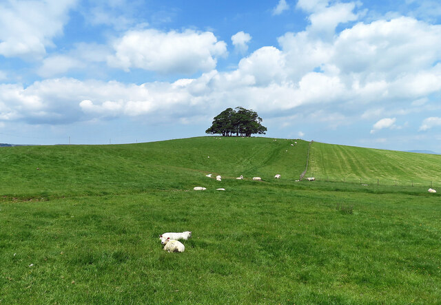
Lower Tarn Coppy Plantation is a picturesque woodland located in the county of Yorkshire, England. Situated in the heart of the countryside, this enchanting forest covers an area of approximately 200 acres and is known for its diverse range of flora and fauna.

The plantation is predominantly composed of native tree species, including oak, beech, and birch, which thrive in the fertile soil and temperate climate of the region. The woodland is divided into several distinct areas, each characterized by its unique vegetation and topography.

Lower Tarn Coppy Plantation offers a variety of recreational activities for visitors to enjoy. There are well-maintained walking trails that meander through the forest, allowing nature enthusiasts to explore the dense foliage and discover hidden pockets of tranquility. The trails are suitable for all abilities, with options for leisurely strolls or more challenging hikes.

This woodland also provides a haven for wildlife, with many bird species, such as woodpeckers and owls, making their homes among the trees. Additionally, the forest is home to a variety of mammals, including deer and squirrels, which can often be spotted darting through the undergrowth.

Lower Tarn Coppy Plantation is well-maintained and cared for by local conservation groups, ensuring its continued natural beauty and ecological significance. It serves as an important habitat for native species and acts as a valuable resource for educational purposes.

Overall, Lower Tarn Coppy Plantation is a captivating woodland that offers a peaceful retreat for nature lovers and provides a sanctuary for a diverse range of plants and animals.

If you have any feedback on the listing, please let us know in the comments section below.

Lower Tarn Coppy Plantation Images

Images are sourced within 2km of 54.014521/-2.2968423 or Grid Reference SD8057. Thanks to Geograph Open Source API. All images are credited.

This way to Tosside The B6478 viewed near Hill Top Farm.
This way to Tosside
The B6478 viewed near Hill Top Farm.
Hill Top Farm A mid-June view of grazing land in the Ribble valley.
Hill Top Farm
A mid-June view of grazing land in the Ribble valley.
Farmland view near Wigglesworth A mid-June view looking towards Teenley Hill from Church Lane. The foreground of this shot lies inside the square.
Farmland view near Wigglesworth
A mid-June view looking towards Teenley Hill from Church Lane. The foreground of this shot lies inside the square.
Approaching Wigglesworth The cyclist is entering Wigglesworth on Church Lane.
Approaching Wigglesworth
The cyclist is entering Wigglesworth on Church Lane.
Happy and glorious Wigglesworth celebrated the Platinum Jubilee by erecting a stylish village sign.
Happy and glorious
Wigglesworth celebrated the Platinum Jubilee by erecting a stylish village sign.
Plough Inn, Wigglesworth An attractive village hostelry in Ribblesdale.
Plough Inn, Wigglesworth
An attractive village hostelry in Ribblesdale.
North Hill Plantation North Hill Plantation lies on the left-hand side of the road with Hole House Plantation on the right.
North Hill Plantation
North Hill Plantation lies on the left-hand side of the road with Hole House Plantation on the right.
Ribblesdale farmland view This ground lies on the north side of Wigglesworth village.
Ribblesdale farmland view
This ground lies on the north side of Wigglesworth village.
Wigglesworth Hall Farm The farm road-end viewed from Jack Lane.
Wigglesworth Hall Farm
The farm road-end viewed from Jack Lane.
On Jack Lane The road between Rathmell and Wigglesworth.
On Jack Lane
The road between Rathmell and Wigglesworth.
Approaching Hollow Gill Wood The buildings of Cockley Bank are shown on the left.
Approaching Hollow Gill Wood
The buildings of Cockley Bank are shown on the left.
Towards Ribblesdale Looking towards the flood plain of the River Ribble from Jack Lane on a dullish mid-June afternoon.
Towards Ribblesdale
Looking towards the flood plain of the River Ribble from Jack Lane on a dullish mid-June afternoon.
Stocks in the Plough Hotel Car Park at Wigglesworth A set of stocks located on the car park at the Plough Hotel in Wigglesworth. A sign by the stocks in Oldham, Hampshire, England has the follwowing text displayed  "In the year 1376 The Commons ordered that stocks be set up in every town and village "to encourage virtue and discourage evil doers."
Stocks in the Plough Hotel Car Park at Wigglesworth
A set of stocks located on the car park at the Plough Hotel in Wigglesworth. A sign by the stocks in Oldham, Hampshire, England has the follwowing text displayed "In the year 1376 The Commons ordered that stocks be set up in every town and village "to encourage virtue and discourage evil doers."
Flooded fields in Ribblesdale
New House Farm
New House Farm
Who'd a thowt it Whoever thought of it, that way named it, that way
Who'd a thowt it
Whoever thought of it, that way named it, that way
Plantation Green Hippins From Tod Holes Lane
Plantation Green Hippins
From Tod Holes Lane
Gate Gate on the footpath from Green Hippens to Hard Head Farm at the west corner of Green Hippens Plantation
Gate
Gate on the footpath from Green Hippens to Hard Head Farm at the west corner of Green Hippens Plantation
Show me another place!

Lower Tarn Coppy Plantation is located at Grid Ref: SD8057 (Lat: 54.014521, Lng: -2.2968423)

Division: West Riding

Administrative County: North Yorkshire

District: Craven

Police Authority: North Yorkshire

What 3 Words

///spark.freezers.invest. Near Hellifield, North Yorkshire

Related Wikis

Wigglesworth

Wigglesworth is a village and civil parish in the Craven district of North Yorkshire, England. The population of the civil parish taken at the 2011 Census...

Rathmell

Rathmell is a village and civil parish in the Craven district of North Yorkshire, England. The population of the civil parish in the 2011 census was 305...

Long Preston railway station

Long Preston is a railway station on the Bentham Line, which runs between Leeds and Morecambe via Skipton. The station, situated 37+1⁄2 miles (60 km) north...

Long Preston

Long Preston is a village and civil parish in the Craven district of North Yorkshire, England, in the Yorkshire Dales. It lies along the A65 road, and...

Settle Junction railway station

Settle Junction railway station was located near the town of Settle, North Yorkshire, England, immediately to south of the junction between the Midland...

Tosside

Tosside is a small village on the modern border of North Yorkshire and Lancashire in Northern England. It lies within the Forest of Bowland, and is between...

Gisburn Forest

Gisburn Forest is a civil parish in the Ribble Valley, in Lancashire, England. Mainly lying within the Forest of Bowland Area of Outstanding Natural Beauty...

Manor House, Gisburn Forest

Manor House is an historic building in Gisburn Forest, Lancashire, England. It was built in the early 18th century, but contains a section that is believed...

Nearby Amenities

Located within 500m of 54.014521,-2.2968423
Seed Hill
Natural: peak
Source: OS 1:25k
Lat/Long: 54.0158185/-2.2921297
Power: pole
Lat/Long: 54.0190092/-2.2963464
Power: pole
Lat/Long: 54.0183757/-2.2959709
Power: pole
Lat/Long: 54.0173829/-2.2955096
Power: pole
Lat/Long: 54.0166989/-2.2952682
Power: pole
Lat/Long: 54.0157439/-2.2947478
Power: pole
Lat/Long: 54.0152112/-2.2944796
Power: pole
Lat/Long: 54.015517/-2.2930795
Power: pole
Lat/Long: 54.0153205/-2.2913924
Power: pole
Lat/Long: 54.0154242/-2.2900773
Power: pole
Lat/Long: 54.0113865/-2.3012897
Power: pole
Lat/Long: 54.0112743/-2.2999056
Power: pole
Lat/Long: 54.011179/-2.298838
Power: pole
Lat/Long: 54.011061/-2.2974978
Power: pole
Lat/Long: 54.0109407/-2.2961053
Power: pole
Lat/Long: 54.0105316/-2.2949177
The data included in this document is from www.openstreetmap.org. The data is made available under ODbL.

Have you been to Lower Tarn Coppy Plantation?

Leave your review of Lower Tarn Coppy Plantation below (or comments, questions and feedback).