Half Moon Plantation

Wood, Forest in Staffordshire South Staffordshire

England

Half Moon Plantation

Farmland south of Beckbury, Shropshire Seen from the bridleway linking Beckbury and Stableford. Another bridleway, leading to the unsurfaced Lockley's Lane, then Badger Lane, runs along the field on the right and past that woodland on the right.
Farmland south of Beckbury, Shropshire Credit: Roger Kidd

Half Moon Plantation is a woodland area located in Staffordshire, England. It is nestled in the heart of the county, near the town of Wood and close to the renowned Forest of Staffordshire. Covering an expansive area of approximately 500 acres, Half Moon Plantation is a picturesque destination that offers visitors a tranquil and immersive experience in nature.

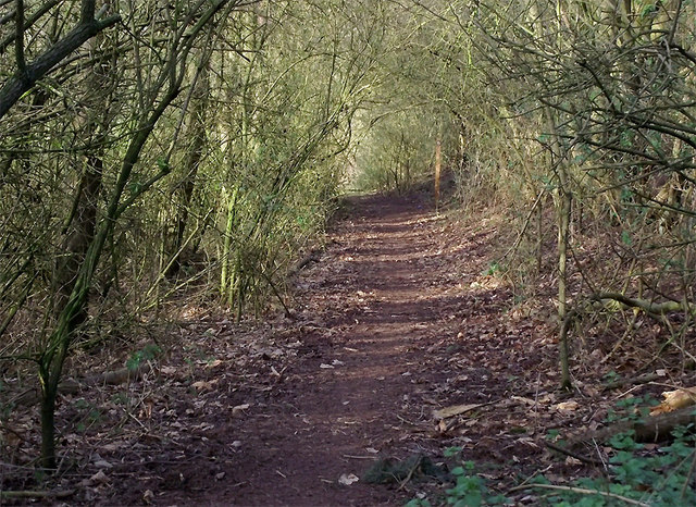
The plantation is characterized by its diverse ecosystem, featuring a variety of tree species such as oak, birch, and beech. These towering trees provide a lush canopy, creating a cool and shaded environment even during the summer months. The forest floor is adorned with a carpet of vibrant wildflowers and ferns, adding to the enchanting atmosphere.

Half Moon Plantation is home to a rich array of wildlife, making it a popular spot for nature enthusiasts. Visitors may spot deer, foxes, badgers, and a plethora of bird species, including woodpeckers and owls. The plantation also boasts a network of well-maintained nature trails, allowing visitors to explore its beauty on foot or by bike.

In addition to its natural wonders, Half Moon Plantation offers a range of recreational activities. It features designated picnic areas, perfect for enjoying a leisurely lunch amidst the serene surroundings. There are also several fishing spots along the river that runs through the plantation, attracting angling enthusiasts from near and far.

Overall, Half Moon Plantation is a hidden gem in Staffordshire, offering a peaceful retreat for those seeking solace in nature. With its diverse flora and fauna, well-maintained trails, and recreational facilities, it is a destination that appeals to both outdoor enthusiasts and those looking to unwind in a serene environment.

If you have any feedback on the listing, please let us know in the comments section below.

Half Moon Plantation Images

Images are sourced within 2km of 52.599971/-2.3248012 or Grid Reference SJ7800. Thanks to Geograph Open Source API. All images are credited.

Farmland south of Beckbury, Shropshire Seen from the bridleway linking Beckbury and Stableford. Another bridleway, leading to the unsurfaced Lockley's Lane, then Badger Lane, runs along the field on the right and past that woodland on the right.
Farmland south of Beckbury, Shropshire
Seen from the bridleway linking Beckbury and Stableford. Another bridleway, leading to the unsurfaced Lockley's Lane, then Badger Lane, runs along the field on the right and past that woodland on the right.
Farmland north of Badger, Shropshire This is land east of Badger Farm, looking towards Riddens Coppice.
Farmland north of Badger, Shropshire
This is land east of Badger Farm, looking towards Riddens Coppice.
Farmland north of Badger, Shropshire Crop fields east of Badger Farm, seen from Badger Lane.
Farmland north of Badger, Shropshire
Crop fields east of Badger Farm, seen from Badger Lane.
Farmland north of Badger, Shropshire This crop field is seen from Badger Lane, looking past the northern edge of Riddens Coppice.
Farmland north of Badger, Shropshire
This crop field is seen from Badger Lane, looking past the northern edge of Riddens Coppice.
Footpath across fields north of Badger, Shropshire The reddish colour of the soil here reveals the presence of Triassic sandstone rock below the surface. The field appears to have been prepared to grow spring onions, or similar.
Footpath across fields north of Badger, Shropshire
The reddish colour of the soil here reveals the presence of Triassic sandstone rock below the surface. The field appears to have been prepared to grow spring onions, or similar.
Footpath across fields north of Badger, Shropshire The reddish colour of the soil here reveals the presence of Triassic sandstone rock below the surface. The field appears to have been prepared to grow spring onions, or similar. There are many footpaths and bridleways in this vicinity, all very well way-marked, and provide excellent rural walking routes.
Footpath across fields north of Badger, Shropshire
The reddish colour of the soil here reveals the presence of Triassic sandstone rock below the surface. The field appears to have been prepared to grow spring onions, or similar. There are many footpaths and bridleways in this vicinity, all very well way-marked, and provide excellent rural walking routes.
Footpath to Beckbury, north of Badger, Shropshire The reddish colour of the soil here reveals the presence of Triassic sandstone rock below the surface. The field appears to have been planted with spring onions, or similar. There are many footpaths and bridleways in this vicinity, all very well way-marked, and provide excellent rural walking routes.
Footpath to Beckbury, north of Badger, Shropshire
The reddish colour of the soil here reveals the presence of Triassic sandstone rock below the surface. The field appears to have been planted with spring onions, or similar. There are many footpaths and bridleways in this vicinity, all very well way-marked, and provide excellent rural walking routes.
Footpath to Beckbury, north of Badger, Shropshire The reddish colour of the soil here reveals the presence of Triassic sandstone rock below the surface. The field appears to have been prepared to grow spring onions, or similar. There are many footpaths and bridleways in this vicinity, all very well way-marked, and provide excellent rural walking routes.
Footpath to Beckbury, north of Badger, Shropshire
The reddish colour of the soil here reveals the presence of Triassic sandstone rock below the surface. The field appears to have been prepared to grow spring onions, or similar. There are many footpaths and bridleways in this vicinity, all very well way-marked, and provide excellent rural walking routes.
Footpath across fields near Beckbury The reddish colour of the soil here reveals the presence of Triassic sandstone rock below the surface. The field appears to have been planted with spring onions, or similar. There are many footpaths and bridleways in this vicinity, all very well way-marked, and provide excellent rural walking routes.
Footpath across fields near Beckbury
The reddish colour of the soil here reveals the presence of Triassic sandstone rock below the surface. The field appears to have been planted with spring onions, or similar. There are many footpaths and bridleways in this vicinity, all very well way-marked, and provide excellent rural walking routes.
Crop field north of Badger, Shropshire The reddish colour of the soil here reveals the presence of Triassic sandstone rock below the surface. The field appears to have been prepared to grow spring onions, or similar. The deep troughs are exactly the correct width for the tractor wheels, and the raised soil in between seems to have been prepared for five lines of onions (The earlier crop in the field to the north has six lines).

Badger Lane crosses behind the hedge and beyond that is the northern part of Riddens Coppice.
Crop field north of Badger, Shropshire
The reddish colour of the soil here reveals the presence of Triassic sandstone rock below the surface. The field appears to have been prepared to grow spring onions, or similar. The deep troughs are exactly the correct width for the tractor wheels, and the raised soil in between seems to have been prepared for five lines of onions (The earlier crop in the field to the north has six lines). Badger Lane crosses behind the hedge and beyond that is the northern part of Riddens Coppice.
Crop field north of Badger, Shropshire The crop growing here looks like spring onions. There are six drills of onions between each trench, which is about 30cm deep and guides the wheels of the tractor which pulls the crop maintenance equipment. Badger Lane, between Badger and Beckbury villages crosses the image in the middle of the image. A little further south, the set-up appears to be for five drills between each trench, and the crop has yet to show signs of germination. <a href="https://www.geograph.org.uk/photo/2322193">SJ7600 : Crop field north of Badger, Shropshire</a>

<a href="https://www.geograph.org.uk/photo/2322528">SJ7600 : Spring Onions growing near Badger, Shropshire</a>
Crop field north of Badger, Shropshire
The crop growing here looks like spring onions. There are six drills of onions between each trench, which is about 30cm deep and guides the wheels of the tractor which pulls the crop maintenance equipment. Badger Lane, between Badger and Beckbury villages crosses the image in the middle of the image. A little further south, the set-up appears to be for five drills between each trench, and the crop has yet to show signs of germination. SJ7600 : Crop field north of Badger, Shropshire SJ7600 : Spring Onions growing near Badger, Shropshire
Spring Onions growing near Badger, Shropshire The crop growing here looks like spring onions. There are six drills of onions between each trench, which is about 30cm deep and guides the wheels of the tractor which pulls the crop maintenance equipment. Badger Lane, between Badger and Beckbury villages crosses the image just beyond the tractor.

In this image, the tractor is very slowly pulling a tilling mechanism consisting of fifteen vertical stainless steel spikes about 20cm long, which are tilling the soil between the six drills of onions in each strip of ground. This needs to be set up with some precision to avoid ripping up the crop!

A little further south, the set-up appears to be for five drills between each trench, and the crop has yet to show signs of germination. <a href="https://www.geograph.org.uk/photo/2322193">SJ7600 : Crop field north of Badger, Shropshire</a>
Spring Onions growing near Badger, Shropshire
The crop growing here looks like spring onions. There are six drills of onions between each trench, which is about 30cm deep and guides the wheels of the tractor which pulls the crop maintenance equipment. Badger Lane, between Badger and Beckbury villages crosses the image just beyond the tractor. In this image, the tractor is very slowly pulling a tilling mechanism consisting of fifteen vertical stainless steel spikes about 20cm long, which are tilling the soil between the six drills of onions in each strip of ground. This needs to be set up with some precision to avoid ripping up the crop! A little further south, the set-up appears to be for five drills between each trench, and the crop has yet to show signs of germination. SJ7600 : Crop field north of Badger, Shropshire
Spring Onions growing near Badger, Shropshire The crop growing here looks like spring onions. There are six drills of onions between each trench, which is about 30cm deep and guides the wheels of the tractor which pulls the crop maintenance equipment. Badger Lane, between Badger and Beckbury villages crosses the image just beyond the tractor.

In this image, the tractor is very slowly pulling a tilling mechanism consisting of fifteen vertical stainless steel spikes about 20cm long, which are tilling the soil between the six drills of onions in each strip of ground. This needs to be set up with some precision to avoid ripping up the crop! Compare this image with another one showing the onions before the farmer has been over it. 
<a href="https://www.geograph.org.uk/photo/2322985">SJ7600 : Crop field north of Badger, Shropshire</a>

A little further south, the set-up appears to be for five drills between each trench, and the crop has yet to show signs of germination. <a href="https://www.geograph.org.uk/photo/2322193">SJ7600 : Crop field north of Badger, Shropshire</a>
Spring Onions growing near Badger, Shropshire
The crop growing here looks like spring onions. There are six drills of onions between each trench, which is about 30cm deep and guides the wheels of the tractor which pulls the crop maintenance equipment. Badger Lane, between Badger and Beckbury villages crosses the image just beyond the tractor. In this image, the tractor is very slowly pulling a tilling mechanism consisting of fifteen vertical stainless steel spikes about 20cm long, which are tilling the soil between the six drills of onions in each strip of ground. This needs to be set up with some precision to avoid ripping up the crop! Compare this image with another one showing the onions before the farmer has been over it. SJ7600 : Crop field north of Badger, Shropshire A little further south, the set-up appears to be for five drills between each trench, and the crop has yet to show signs of germination. SJ7600 : Crop field north of Badger, Shropshire
Crop field north of Badger, Shropshire The crop growing here looks like spring onions. There are six drills of onions between each trench, which is about 30cm deep and guides the wheels of the tractor which pulls the crop maintenance equipment. Badger Lane, between Badger and Beckbury villages crosses the image in the middle of the image. A little further south, the set-up appears to be for five drills between each trench, and the crop has yet to show signs of germination. <a href="https://www.geograph.org.uk/photo/2322193">SJ7600 : Crop field north of Badger, Shropshire</a>

<a href="https://www.geograph.org.uk/photo/2322528">SJ7600 : Spring Onions growing near Badger, Shropshire</a>
Crop field north of Badger, Shropshire
The crop growing here looks like spring onions. There are six drills of onions between each trench, which is about 30cm deep and guides the wheels of the tractor which pulls the crop maintenance equipment. Badger Lane, between Badger and Beckbury villages crosses the image in the middle of the image. A little further south, the set-up appears to be for five drills between each trench, and the crop has yet to show signs of germination. SJ7600 : Crop field north of Badger, Shropshire SJ7600 : Spring Onions growing near Badger, Shropshire
Footpath near Beckbury, Shropshire There are two paths down the steep wooded strip of woodland; this one leads through the woods, north to Beckbury. Through another gate (off to the left) a path descends directly to the River Worfe.
Footpath near Beckbury, Shropshire
There are two paths down the steep wooded strip of woodland; this one leads through the woods, north to Beckbury. Through another gate (off to the left) a path descends directly to the River Worfe.
Gateway to Beckbury, Shropshire There are two paths down the steep wooded strip of woodland, which covers a sandstone scarp slope; this one leads through the woods, north to Beckbury. Through another gate (off to the left) a path descends directly the bridleway (Higford Lane).

There are many footpaths and bridleways in this vicinity, all very well way-marked, and provide excellent rural walking routes. This image is from another location: <a href="https://www.geograph.org.uk/photo/2317077">SJ7500 : Footpath way-marker near Beckbury, Shropshire</a>
Gateway to Beckbury, Shropshire
There are two paths down the steep wooded strip of woodland, which covers a sandstone scarp slope; this one leads through the woods, north to Beckbury. Through another gate (off to the left) a path descends directly the bridleway (Higford Lane). There are many footpaths and bridleways in this vicinity, all very well way-marked, and provide excellent rural walking routes. This image is from another location: SJ7500 : Footpath way-marker near Beckbury, Shropshire
Gate and footpath south of Beckbury, Shropshire There are two paths down the steep wooded strip of woodland which covers a sandstone scarp slope; this one leads through the woods, to the bridleway (Higford Lane). Through another gate (off to the right) a path goes north through the woods towards Beckbury.

There are many footpaths and bridleways in this vicinity, all very well way-marked, and provide excellent rural walking routes. This image is from another location: <a href="https://www.geograph.org.uk/photo/2317077">SJ7500 : Footpath way-marker near Beckbury, Shropshire</a>
Gate and footpath south of Beckbury, Shropshire
There are two paths down the steep wooded strip of woodland which covers a sandstone scarp slope; this one leads through the woods, to the bridleway (Higford Lane). Through another gate (off to the right) a path goes north through the woods towards Beckbury. There are many footpaths and bridleways in this vicinity, all very well way-marked, and provide excellent rural walking routes. This image is from another location: SJ7500 : Footpath way-marker near Beckbury, Shropshire
Woodland footpath to Beckbury, Shropshire The public footpath leads towards the Seven Stars public house along a strip of woodland which covers a sandstone scarp slope.
Woodland footpath to Beckbury, Shropshire
The public footpath leads towards the Seven Stars public house along a strip of woodland which covers a sandstone scarp slope.
Show me another place!

Half Moon Plantation is located at Grid Ref: SJ7800 (Lat: 52.599971, Lng: -2.3248012)

Administrative County: Staffordshire

District: South Staffordshire

Police Authority: Staffordshire

What 3 Words

///soil.incursion.narrow. Near Ryton, Shropshire

Related Wikis

Burnhill Green

Burnhill Green is a small hamlet near Pattingham, situated in Staffordshire, England, in the former parish of Patshull. The hamlet is on the edge of the...

Badger, Shropshire

Badger is a village and civil parish in Shropshire, England, about six miles north-east of Bridgnorth. The parish had a population of 134 according to...

Ackleton

Ackleton is a village in the English county of Shropshire. It is in the civil parish of Worfield. Situated some seven miles (11 kilometers) from the market...

St Mary's Church, Patshull

St Mary's Church, Patshull, is a redundant Anglican church in the parish of Pattingham and Patshull, Staffordshire, England, and is situated near Patshull...

Beckbury

Beckbury is a village and civil parish in Shropshire, England. Beckbury had a population of 327 according to the 2001 census, increasing to 340 at the...

Patshull

Patshull is a former civil parish, now in the parish of Pattingham and Patshull, in the South Staffordshire district, in the county of Staffordshire, England...

Patshull Hall

Patshull Hall is a substantial Georgian mansion house situated near Pattingham in Staffordshire, England. It is a Grade I listed building and by repute...

Caynton Caves

The Caynton Caves are a series of man-made underground chambers in the grounds of Caynton Hall, near Beckbury, Shropshire, England. Their original purpose...

Nearby Amenities

Located within 500m of 52.599971,-2.3248012
Power: tower
Source: bing
Lat/Long: 52.5970758/-2.3254788
Power: tower
Source: bing
Lat/Long: 52.599258/-2.3290104
Turning Loop
Lat/Long: 52.6042352/-2.3232296
The data included in this document is from www.openstreetmap.org. The data is made available under ODbL.

Have you been to Half Moon Plantation?

Leave your review of Half Moon Plantation below (or comments, questions and feedback).