Black Plantation

Wood, Forest in Yorkshire Craven

England

Black Plantation

Direction Sign – Signpost on Eldroth Road, Lawkland Located on the northwest side of the T junction of Eldroth Road and Fummerber Lane in Lawkland parish. 3 arms and annulus & bar finial. See also <a title="https://www.geograph.org.uk/photo/5834757" href="https://www.geograph.org.uk/photo/5834757">Link</a> and <a title="https://www.geograph.org.uk/photo/4613723" href="https://www.geograph.org.uk/photo/4613723">Link</a>.

Milestone Society National ID: YW_SD7466A
Direction Sign – Signpost on Eldroth Road, Lawkland Credit: D Phillips

Black Plantation is a woodland area located in the county of Yorkshire, England. Situated in the village of Wood, the plantation covers a significant area of dense forest and is known for its striking black appearance, which is attributed to the presence of predominantly dark-colored trees.

The plantation is home to a variety of tree species, including oak, beech, and birch, which contribute to the rich biodiversity of the area. The tall and mature trees create a dense canopy, providing a suitable habitat for numerous wildlife species, such as birds, squirrels, and deer. The woodland floor is carpeted with a diverse range of plants, including bluebells, ferns, and mosses, adding to the natural beauty of the area.

Black Plantation offers a tranquil and serene environment, attracting visitors who seek solitude and a connection with nature. The woodland is crisscrossed by a network of well-maintained footpaths, providing opportunities for leisurely walks and exploration. The surrounding countryside offers picturesque views, with rolling hills and meandering streams adding to the charm of the landscape.

The plantation holds historical significance as well. It is believed to have been used as a hunting ground during medieval times and has witnessed various changes throughout history, including the expansion of the nearby village of Wood. The area's heritage is carefully preserved, with efforts made to maintain the natural integrity of the woodland.

Overall, Black Plantation in Yorkshire is a cherished natural asset, offering an escape from the hustle and bustle of modern life, and providing a haven for both wildlife and humans alike.

If you have any feedback on the listing, please let us know in the comments section below.

Black Plantation Images

Images are sourced within 2km of 54.098814/-2.3717305 or Grid Reference SD7567. Thanks to Geograph Open Source API. All images are credited.

Direction Sign – Signpost on Eldroth Road, Lawkland Located on the northwest side of the T junction of Eldroth Road and Fummerber Lane in Lawkland parish. 3 arms and annulus & bar finial. See also <a title="https://www.geograph.org.uk/photo/5834757" href="https://www.geograph.org.uk/photo/5834757">Link</a> and <a title="https://www.geograph.org.uk/photo/4613723" href="https://www.geograph.org.uk/photo/4613723">Link</a>.

Milestone Society National ID: YW_SD7466A
Direction Sign – Signpost on Eldroth Road, Lawkland
Located on the northwest side of the T junction of Eldroth Road and Fummerber Lane in Lawkland parish. 3 arms and annulus & bar finial. See also Link and Link. Milestone Society National ID: YW_SD7466A
Clapham Road - Austwick
At Lawkland Roadside buildings at Bank End Farm.
At Lawkland
Roadside buildings at Bank End Farm.
On Graystonber Lane Viewed on a showery October afternoon.
On Graystonber Lane
Viewed on a showery October afternoon.
New bridge south of Harden Bridge on the A65
Harden Bridge Use to carry the A65 over Austwick Beck
Harden Bridge
Use to carry the A65 over Austwick Beck
Harden Bridge Use to carry the A65 over Austwick Beck
Harden Bridge
Use to carry the A65 over Austwick Beck
Junction of Holm Lane and the A65
Austwick Beck
Austwick Beck
Crina Bottom Farm
Crina Bottom Farm
Junction with the A65 trunk road near Clapham
Pasture by Harden Bridge near Austwick The grass has been cut and is awaiting collection.
Pasture by Harden Bridge near Austwick
The grass has been cut and is awaiting collection.
Former inn (The Cross Streets), A65 near Austwick The old version of my map (2002) still shows this as a pub.  It's now a private house.
Former inn (The Cross Streets), A65 near Austwick
The old version of my map (2002) still shows this as a pub. It's now a private house.
Pasture by Graystonber Lane and the A65 near Austwick Looking towards Moughton and the wooded hill of Oxenber.
Pasture by Graystonber Lane and the A65 near Austwick
Looking towards Moughton and the wooded hill of Oxenber.
Looking up Austwick Beck from Austwick Bridge The beck issues out of the resurgence of Austwick Beck Head in Crummackdale after flowing through several of the deep potholes of The Allotment (eg Juniper Gulf <a title="https://www.geograph.org.uk/photo/2450345)" href="https://www.geograph.org.uk/photo/2450345)">Link</a>. Moughton is the flat-topped hill beyond.
Looking up Austwick Beck from Austwick Bridge
The beck issues out of the resurgence of Austwick Beck Head in Crummackdale after flowing through several of the deep potholes of The Allotment (eg Juniper Gulf Link. Moughton is the flat-topped hill beyond.
Sheep near Austwick The hill of Norber on the skyline with Robin Proctor's Scar prominent on the right.
Sheep near Austwick
The hill of Norber on the skyline with Robin Proctor's Scar prominent on the right.
Austwick village green and cross
Show me another place!

Black Plantation is located at Grid Ref: SD7567 (Lat: 54.098814, Lng: -2.3717305)

Division: West Riding

Administrative County: North Yorkshire

District: Craven

Police Authority: North Yorkshire

What 3 Words

///presides.burying.bedroom. Near Settle, North Yorkshire

Related Wikis

Austwick

Austwick is a village and civil parish in the Craven district of North Yorkshire, England, about 5 miles (8 km) north-west of Settle. The village is on...
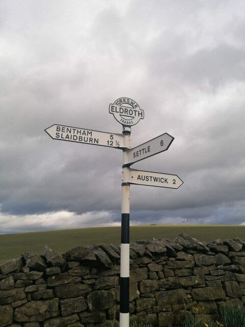
Eldroth

Eldroth is a village in North Yorkshire, England. It is in the civil parish of Lawkland, part of the former Craven District, some 3.25 miles (5.23 km)...

Lawkland

Lawkland is a civil parish in North Yorkshire, England, near the A65 and 4 miles (6.4 km) west of Settle. It lies within the Forest of Bowland Area of...
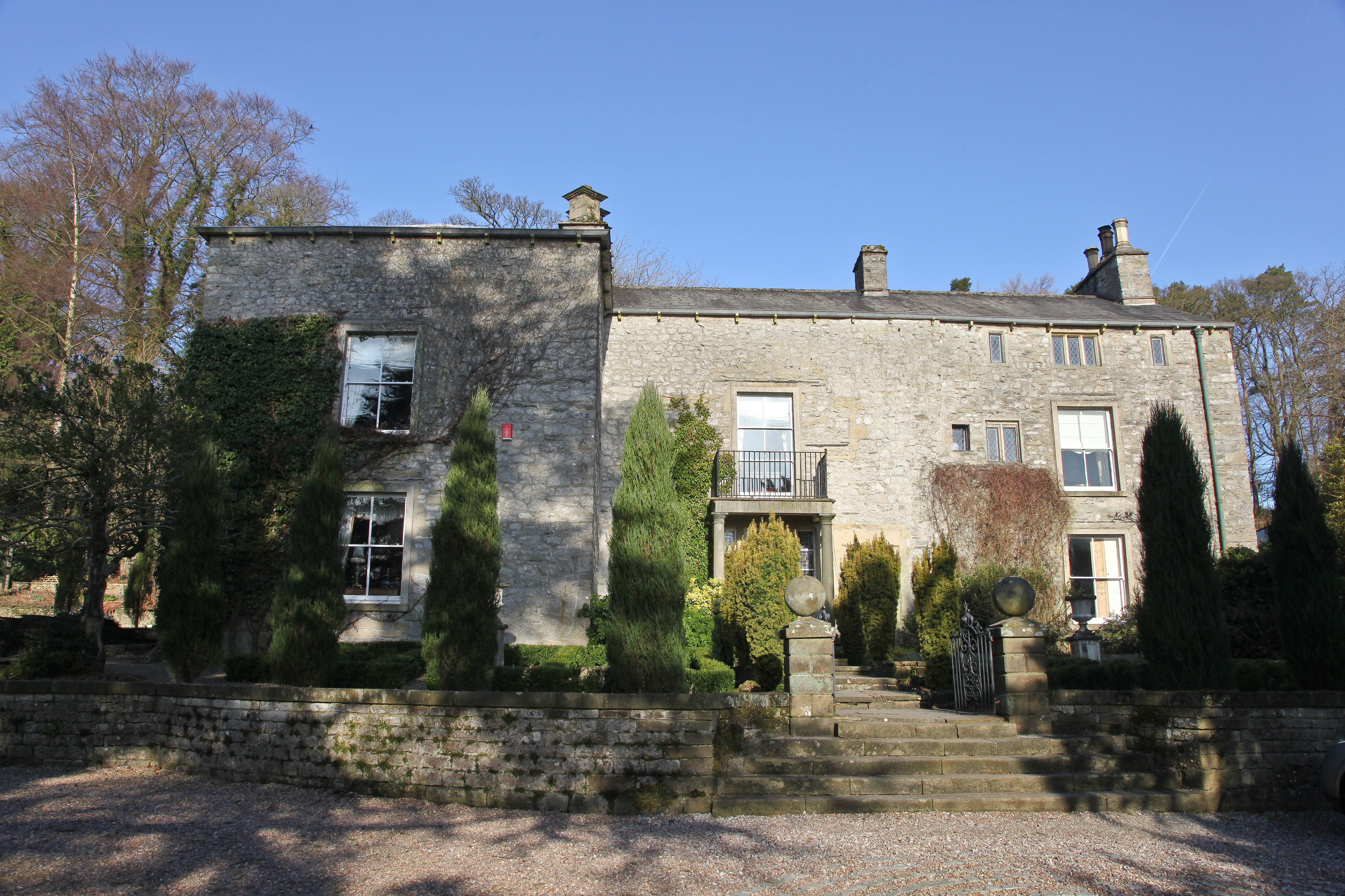
Austwick Hall

Austwick Hall is an historic manor house situated above the village of Austwick in North Yorkshire, England. The house is a Grade II listed building and...

Clapham railway station

Clapham is a railway station on the Bentham Line, which runs between Leeds and Morecambe via Skipton. The station, situated 48 miles (77 km) north-west...

Clapham, North Yorkshire

Clapham is a village in the civil parish of Clapham cum Newby in the Craven district of North Yorkshire, England. It was previously in the West Riding...

Norber erratics

The Norber erratics are one of the finest groups of glacial erratic boulders in Britain. They are found on the southern slopes of Ingleborough, close to...

Clapham cum Newby

Clapham cum Newby is a civil parish in the Craven district of North Yorkshire, England. It was formerly in the Settle Rural District. It contains the villages...

Nearby Amenities

Located within 500m of 54.098814,-2.3717305
Barrier: stile
Lat/Long: 54.1028886/-2.3685141
Barrier: stile
Lat/Long: 54.1013682/-2.3688538
Barrier: stile
Lat/Long: 54.0990247/-2.370439
Power: pole
Lat/Long: 54.1032141/-2.3732185
Power: pole
Lat/Long: 54.102983/-2.3745753
Power: pole
Lat/Long: 54.101864/-2.3773642
Power: pole
Lat/Long: 54.100051/-2.3784318
Power: pole
Lat/Long: 54.0996955/-2.3780786
Power: pole
Lat/Long: 54.0992889/-2.3776674
Power: pole
Lat/Long: 54.0988299/-2.3772008
Power: pole
Lat/Long: 54.0984094/-2.3768054
Power: pole
Lat/Long: 54.0983476/-2.3765181
The data included in this document is from www.openstreetmap.org. The data is made available under ODbL.

Have you been to Black Plantation?

Leave your review of Black Plantation below (or comments, questions and feedback).