Coxley Wick

Settlement in Somerset Mendip

England

Coxley Wick

Pasture by Castle Lane The lane follows the edge of Hay Moor; this view looks across it with Ben Knowle Hill on the left.
Pasture by Castle Lane Credit: Derek Harper

Coxley Wick is a small village located in the picturesque county of Somerset, England. Situated just two miles away from the historic city of Wells, Coxley Wick offers a tranquil and rural escape for its residents and visitors alike.

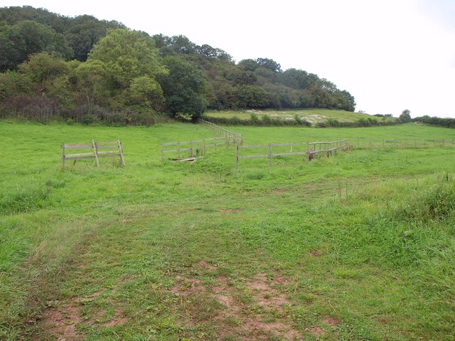
The village is surrounded by lush green fields and rolling hills, providing a stunning backdrop for those who appreciate the beauty of the English countryside. It is known for its charming thatched cottages and traditional architecture, which add to its quaint and idyllic atmosphere.

Despite its small size, Coxley Wick has a close-knit community, with a population of around 500 residents. The village boasts a range of amenities, including a local pub, a village hall, and a primary school, making it an ideal place for families to settle.

Nature enthusiasts will find plenty to explore in Coxley Wick, with numerous walking trails and nature reserves nearby. The village is also conveniently located near the Mendip Hills, a designated Area of Outstanding Natural Beauty, offering stunning views and opportunities for outdoor activities such as hiking and cycling.

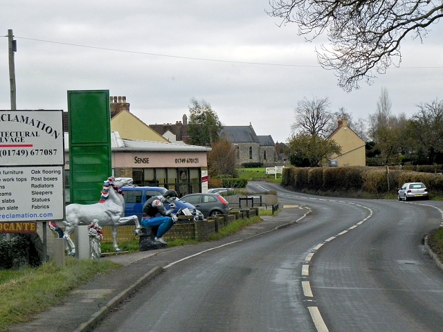
Coxley Wick benefits from its proximity to Wells, a historic city renowned for its stunning cathedral and medieval architecture. Residents of Coxley Wick can easily access a wider range of amenities, shops, and services in Wells, making it a convenient location for daily needs.

Overall, Coxley Wick offers a peaceful and picturesque setting, with a strong sense of community and easy access to both the countryside and nearby city amenities.

If you have any feedback on the listing, please let us know in the comments section below.

Coxley Wick Images

Images are sourced within 2km of 51.192942/-2.675857 or Grid Reference ST5243. Thanks to Geograph Open Source API. All images are credited.

Pasture by Castle Lane The lane follows the edge of Hay Moor; this view looks across it with Ben Knowle Hill on the left.
Pasture by Castle Lane
The lane follows the edge of Hay Moor; this view looks across it with Ben Knowle Hill on the left.
Slopes of Hembury Hill The scene on the opposite side of Castle Lane to <a href="https://www.geograph.org.uk/photo/2589709">ST5144 : Pasture by Castle Lane</a>. Hembury Wood is in <a href="https://www.geograph.org.uk/gridref/ST5044">ST5044</a>.
Slopes of Hembury Hill
The scene on the opposite side of Castle Lane to ST5144 : Pasture by Castle Lane. Hembury Wood is in ST5044.
Here be giants ...! At the western end of Coxley, the bull, statue of "The Thinker" and the horse advertise an architectural reclamation yard to the north of the filling station
Here be giants ...!
At the western end of Coxley, the bull, statue of "The Thinker" and the horse advertise an architectural reclamation yard to the north of the filling station
The Pound Inn, Coxley
Footpath near Woodford Bridge The kissing gate leads to a fence; the footpath leads beside the field of maize
Footpath near Woodford Bridge
The kissing gate leads to a fence; the footpath leads beside the field of maize
Maize field and solitary tree near Woodford Bridge
Mendip : Glastonbury Tor & Countryside Looking towards Glastonbury Tor and surrounding countryside from Wells Road A39.
Mendip : Glastonbury Tor & Countryside
Looking towards Glastonbury Tor and surrounding countryside from Wells Road A39.
A39, Wells Road, Coxley The A39 is one of the longest routes in South West England. It stretches from Bath in Somerset to Falmouth in Cornwall passing some famous historical places including Wells and Glastonbury and touring along the Somerset, Devon and Cornish Coasts, before skirting to the north of Bodmin Moor and crossing the county to the historic port of Falmouth on the southern shore. The section running between the North Devon Link Road at Barnstaple in Devon and the A30 at Fraddon in Cornwall is known as the Atlantic Highway, and was classified as a trunk road until 2002.
A39, Wells Road, Coxley
The A39 is one of the longest routes in South West England. It stretches from Bath in Somerset to Falmouth in Cornwall passing some famous historical places including Wells and Glastonbury and touring along the Somerset, Devon and Cornish Coasts, before skirting to the north of Bodmin Moor and crossing the county to the historic port of Falmouth on the southern shore. The section running between the North Devon Link Road at Barnstaple in Devon and the A30 at Fraddon in Cornwall is known as the Atlantic Highway, and was classified as a trunk road until 2002.
Coxley, Main Road (A39) and Christ Church Christ Church at Coxley is a Commissioners' Church <span class="nowrap"><a title="http://en.wikipedia.org/wiki/Commissioners%27_church" rel="nofollow ugc noopener" href="http://en.wikipedia.org/wiki/Commissioners%27_church">Link</a><img style="margin-left:2px;" alt="External link" title="External link - shift click to open in new window" src="https://s1.geograph.org.uk/img/external.png" width="10" height="10"/></span>  built 1838-9 in the Gothic Revival style. It is a Grade II listed building (English Heritage ID:268127 <span class="nowrap"><a title="http://www.britishlistedbuildings.co.uk/en-268127-christ-church-st-cuthbert-out-somerset" rel="nofollow ugc noopener" href="http://www.britishlistedbuildings.co.uk/en-268127-christ-church-st-cuthbert-out-somerset">Link</a><img style="margin-left:2px;" alt="External link" title="External link - shift click to open in new window" src="https://s1.geograph.org.uk/img/external.png" width="10" height="10"/></span>  British Listed Buildings)
Coxley, Main Road (A39) and Christ Church
Christ Church at Coxley is a Commissioners' Church LinkExternal link built 1838-9 in the Gothic Revival style. It is a Grade II listed building (English Heritage ID:268127 LinkExternal link British Listed Buildings)
Christ Church, Coxley Christ Church at Coxley is a Commissioners' Church <span class="nowrap"><a title="http://en.wikipedia.org/wiki/Commissioners%27_church" rel="nofollow ugc noopener" href="http://en.wikipedia.org/wiki/Commissioners%27_church">Link</a><img style="margin-left:2px;" alt="External link" title="External link - shift click to open in new window" src="https://s1.geograph.org.uk/img/external.png" width="10" height="10"/></span>  built 1838-9 in the Gothic Revival style. It is a Grade II listed building (English Heritage ID:268127 <span class="nowrap"><a title="http://www.britishlistedbuildings.co.uk/en-268127-christ-church-st-cuthbert-out-somerset" rel="nofollow ugc noopener" href="http://www.britishlistedbuildings.co.uk/en-268127-christ-church-st-cuthbert-out-somerset">Link</a><img style="margin-left:2px;" alt="External link" title="External link - shift click to open in new window" src="https://s1.geograph.org.uk/img/external.png" width="10" height="10"/></span>  British Listed Buildings)
Christ Church, Coxley
Christ Church at Coxley is a Commissioners' Church LinkExternal link built 1838-9 in the Gothic Revival style. It is a Grade II listed building (English Heritage ID:268127 LinkExternal link British Listed Buildings)
Coxley Main Road (A39) The A39 is one of the longest routes in South West England. It stretches from Bath in Somerset to Falmouth in Cornwall passing some famous historical places including Wells and Glastonbury and touring along the Somerset, Devon and Cornish Coasts, before skirting to the north of Bodmin Moor and crossing the county to the historic port of Falmouth on the southern shore. The section running between the North Devon Link Road at Barnstaple in Devon and the A30 at Fraddon in Cornwall is known as the Atlantic Highway, and was classified as a trunk road until 2002.
Coxley Main Road (A39)
The A39 is one of the longest routes in South West England. It stretches from Bath in Somerset to Falmouth in Cornwall passing some famous historical places including Wells and Glastonbury and touring along the Somerset, Devon and Cornish Coasts, before skirting to the north of Bodmin Moor and crossing the county to the historic port of Falmouth on the southern shore. The section running between the North Devon Link Road at Barnstaple in Devon and the A30 at Fraddon in Cornwall is known as the Atlantic Highway, and was classified as a trunk road until 2002.
Coxley Main Road, The Pound Inn The A39 is one of the longest routes in South West England. It stretches from Bath in Somerset to Falmouth in Cornwall passing some famous historical places including Wells and Glastonbury and touring along the Somerset, Devon and Cornish Coasts, before skirting to the north of Bodmin Moor and crossing the county to the historic port of Falmouth on the southern shore. The section running between the North Devon Link Road at Barnstaple in Devon and the A30 at Fraddon in Cornwall is known as the Atlantic Highway, and was classified as a trunk road until 2002.
Coxley Main Road, The Pound Inn
The A39 is one of the longest routes in South West England. It stretches from Bath in Somerset to Falmouth in Cornwall passing some famous historical places including Wells and Glastonbury and touring along the Somerset, Devon and Cornish Coasts, before skirting to the north of Bodmin Moor and crossing the county to the historic port of Falmouth on the southern shore. The section running between the North Devon Link Road at Barnstaple in Devon and the A30 at Fraddon in Cornwall is known as the Atlantic Highway, and was classified as a trunk road until 2002.
A39, Glastonbury Road The A39 is one of the longest routes in South West England. It stretches from Bath in Somerset to Falmouth in Cornwall passing some famous historical places including Wells and Glastonbury and touring along the Somerset, Devon and Cornish Coasts, before skirting to the north of Bodmin Moor and crossing the county to the historic port of Falmouth on the southern shore. The section running between the North Devon Link Road at Barnstaple in Devon and the A30 at Fraddon in Cornwall is known as the Atlantic Highway, and was classified as a trunk road until 2002.
A39, Glastonbury Road
The A39 is one of the longest routes in South West England. It stretches from Bath in Somerset to Falmouth in Cornwall passing some famous historical places including Wells and Glastonbury and touring along the Somerset, Devon and Cornish Coasts, before skirting to the north of Bodmin Moor and crossing the county to the historic port of Falmouth on the southern shore. The section running between the North Devon Link Road at Barnstaple in Devon and the A30 at Fraddon in Cornwall is known as the Atlantic Highway, and was classified as a trunk road until 2002.
Glastonbury Road (A39) approaching Wells The A39 is one of the longest routes in South West England. It stretches from Bath in Somerset to Falmouth in Cornwall passing some famous historical places including Wells and Glastonbury and touring along the Somerset, Devon and Cornish Coasts, before skirting to the north of Bodmin Moor and crossing the county to the historic port of Falmouth on the southern shore. The section running between the North Devon Link Road at Barnstaple in Devon and the A30 at Fraddon in Cornwall is known as the Atlantic Highway, and was classified as a trunk road until 2002.
Glastonbury Road (A39) approaching Wells
The A39 is one of the longest routes in South West England. It stretches from Bath in Somerset to Falmouth in Cornwall passing some famous historical places including Wells and Glastonbury and touring along the Somerset, Devon and Cornish Coasts, before skirting to the north of Bodmin Moor and crossing the county to the historic port of Falmouth on the southern shore. The section running between the North Devon Link Road at Barnstaple in Devon and the A30 at Fraddon in Cornwall is known as the Atlantic Highway, and was classified as a trunk road until 2002.
The Pound Inn, Coxley
Benchmark in Burcott Road A cutmark, as described in the Benchmark Database: <span class="nowrap"><a title="http://www.bench-marks.org.uk/bm58659" rel="nofollow ugc noopener" href="http://www.bench-marks.org.uk/bm58659">Link</a><img style="margin-left:2px;" alt="External link" title="External link - shift click to open in new window" src="https://s1.geograph.org.uk/img/external.png" width="10" height="10"/></span> , on the side of a house in Burcott Road. See <a href="https://www.geograph.org.uk/photo/4066234">ST5445 : A change of address</a> for a wider view of this renumbered road.
Benchmark in Burcott Road
A cutmark, as described in the Benchmark Database: LinkExternal link , on the side of a house in Burcott Road. See ST5445 : A change of address for a wider view of this renumbered road.
A change of address This is number 24 Burcott Road, but look carefully and you will note the number 1 on the door lintel. Clearly there has been a change of numbering at some point, as can be seen on other houses in the area - see <a href="https://www.geograph.org.uk/photo/4066327">ST5445 : A different set of numbers</a>. A benchmark can also be found on this corner of the alleyway - see <a href="https://www.geograph.org.uk/photo/4066215">ST5445 : Benchmark in Burcott Road</a>.
A change of address
This is number 24 Burcott Road, but look carefully and you will note the number 1 on the door lintel. Clearly there has been a change of numbering at some point, as can be seen on other houses in the area - see ST5445 : A different set of numbers. A benchmark can also be found on this corner of the alleyway - see ST5445 : Benchmark in Burcott Road.
A different set of numbers Look closely and you will notice the numbers carved into the lintels are 5 and 6 - not the ones on the actual doors. Clearly the original numbering of Victoria Terrace (in Burcott Road) of 1888 has been changed. The area dates from around the turn of the nineteenth century when there was an isolation hospital just along the road.
A different set of numbers
Look closely and you will notice the numbers carved into the lintels are 5 and 6 - not the ones on the actual doors. Clearly the original numbering of Victoria Terrace (in Burcott Road) of 1888 has been changed. The area dates from around the turn of the nineteenth century when there was an isolation hospital just along the road.
Show me another place!

Coxley Wick is located at Grid Ref: ST5243 (Lat: 51.192942, Lng: -2.675857)

Administrative County: Somerset

District: Mendip

Police Authority: Avon and Somerset

What 3 Words

///gently.craziest.flicks. Near Wells, Somerset

Nearby Locations

Coxley Wick Coxley

Related Wikis

Christ Church, Coxley

Christ Church is a Church of England church in Coxley, Somerset, England. It was built in 1839–40 to the designs of Richard Carver and is a Grade II listed...

Polsham railway station

Polsham was a railway station on the Somerset and Dorset Railway in the village of Polsham, Somerset in England. Opening in December 1861 on the Somerset...

Ben Knowle

Ben Knowle (grid reference ST513450) is a 1.5 hectare geological Site of Special Scientific Interest in Somerset, notified in 1984. Ben Knowle is a natural...

Rowdens Road Cricket Ground, Wells

Rowdens Road is a former first-class cricket ground located in Wells, Somerset. The ground was an early home to Wells Cricket Club, though the club no...

Wells East Somerset railway station

Wells station in the Somerset city of Wells was the terminus of the East Somerset Railway line from Witham and opened when the line was extended from Shepton...

Wells City F.C.

Wells City F.C. are a football club based in Wells, Somerset, England. The club is affiliated to the Somerset County FA. They are currently members of...

St Cuthbert Out

St Cuthbert Out, sometimes Wells St Cuthbert Out, is a civil parish in the Mendip district of Somerset, England. It entirely surrounds (but does not include...

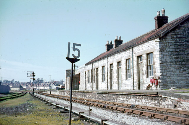
Wells (Priory Road) railway station

Wells (Priory Road) was a railway station on the Somerset and Dorset Joint Railway at Wells in the county of Somerset in England. Opening on 15 March 1859...

Nearby Amenities

Located within 500m of 51.192942,-2.675857
Coxley Wick
Place: hamlet
Source: New Popular Edition
Lat/Long: 51.1948995/-2.675189
Crossing: informal
Lat/Long: 51.1929888/-2.6796194
Power: pole
Lat/Long: 51.1917/-2.6820264
Material: wood
Power: pole
Lat/Long: 51.1922677/-2.681267
Material: wood
Power: pole
Lat/Long: 51.1931305/-2.6824581
Material: wood
Power: pole
Lat/Long: 51.1938492/-2.6811556
Power: pole
Lat/Long: 51.1946116/-2.6799283
Power: pole
Lat/Long: 51.1953857/-2.6786392
Power: pole
Lat/Long: 51.1959916/-2.6776402
Power: pole
Lat/Long: 51.1965099/-2.6768694
Power: pole
Lat/Long: 51.1969576/-2.6753897
Material: wood
Power: pole
Lat/Long: 51.1928193/-2.6805145
Material: wood
Power: pole
Lat/Long: 51.1932712/-2.6797581
Material: wood
Power: pole
Lat/Long: 51.1937314/-2.6789795
Power: pole
Lat/Long: 51.1942193/-2.6781833
Power: pole
Lat/Long: 51.1946019/-2.6775463
Power: pole
Lat/Long: 51.1950343/-2.6768297
Material: wood
Power: pole
Lat/Long: 51.1954834/-2.6760821
Material: wood
Power: pole
Lat/Long: 51.1959242/-2.675361
Material: wood
Power: pole
Lat/Long: 51.1963954/-2.6745427
Power: pole
Lat/Long: 51.1969775/-2.6735651
Public Bookcase
Booth: K6
Disused Amenity: telephone
Man Made: telephone_box
Public Bookcase Type: phone_box
Lat/Long: 51.1899665/-2.675996
Coxley Kitchen Co. Ltd
Shop: kitchen
Lat/Long: 51.1901543/-2.6758205
Bus Stop
The Pound Inn
Bus: yes
Naptan AtcoCode: 3600SOB20992
Naptan Bearing: NE
Naptan CommonName: The Pound Inn
Naptan Indicator: NE-bound
Naptan NaptanCode: sotdagjd
Naptan Street: Main Road
Naptan Verified: no
Public Transport: platform
Lat/Long: 51.1899948/-2.6759651
The data included in this document is from www.openstreetmap.org. The data is made available under ODbL.

Have you been to Coxley Wick?

Leave your review of Coxley Wick below (or comments, questions and feedback).