Coxley

Settlement in Somerset Mendip

England

Coxley

Lane and warning sign
Lane and warning sign Credit: Rob Purvis

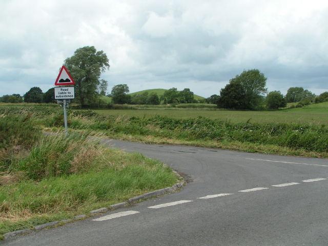
Coxley is a small village located in the Mendip district of Somerset, England. Situated approximately 2 miles east of Wells, it is nestled in the beautiful countryside of the Mendip Hills. Coxley is a rural community with a population of around 450 residents.

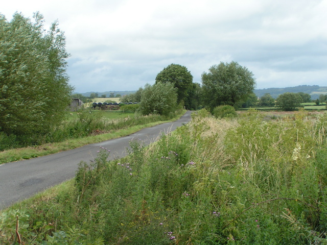
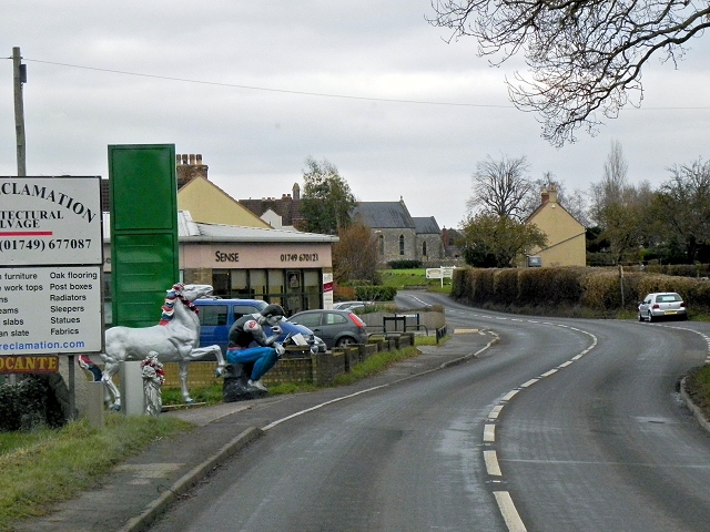
The village is known for its picturesque charm and tranquil atmosphere. It is surrounded by rolling hills, farmland, and meandering rivers, offering stunning vistas and natural beauty. The local architecture is predominantly traditional, with many stone-built cottages and farmhouses dotting the landscape.

Coxley has a rich history, dating back to the Domesday Book of 1086. The village was once an important center for the woollen industry and had several mills operating along the nearby River Sheppey. Today, remnants of these mills can still be seen, adding historical significance to the area.

While Coxley is predominantly residential, it does have a few amenities to cater to its residents' needs. These include a village hall, a primary school, and a local pub. For additional services and facilities, the nearby city of Wells provides a wider range of options.

The village is also well-positioned for outdoor enthusiasts, with numerous walking and cycling trails crisscrossing the surrounding countryside. The Mendip Hills Area of Outstanding Natural Beauty is a short distance away, offering opportunities for hiking, caving, and rock climbing.

Overall, Coxley exudes a peaceful and idyllic charm, making it an appealing place for those seeking a serene rural retreat in the heart of Somerset.

If you have any feedback on the listing, please let us know in the comments section below.

Coxley Images

Images are sourced within 2km of 51.187814/-2.676211 or Grid Reference ST5243. Thanks to Geograph Open Source API. All images are credited.

Lane and warning sign
Wild flowers and trees in the wind
The creeper is winning! The inn is the "Camelot Inn", but the creeper is hiding some of the letters
The creeper is winning!
The inn is the "Camelot Inn", but the creeper is hiding some of the letters
Here be giants ...! At the western end of Coxley, the bull, statue of "The Thinker" and the horse advertise an architectural reclamation yard to the north of the filling station
Here be giants ...!
At the western end of Coxley, the bull, statue of "The Thinker" and the horse advertise an architectural reclamation yard to the north of the filling station
The Pound Inn, Coxley
Footpath near Woodford Bridge The kissing gate leads to a fence; the footpath leads beside the field of maize
Footpath near Woodford Bridge
The kissing gate leads to a fence; the footpath leads beside the field of maize
Maize field and solitary tree near Woodford Bridge
Land for sale, on Queen's Sedge Moor, on the south side of Long Drove
Mendip : Glastonbury Tor & Countryside Looking towards Glastonbury Tor and surrounding countryside from Wells Road A39.
Mendip : Glastonbury Tor & Countryside
Looking towards Glastonbury Tor and surrounding countryside from Wells Road A39.
A39, Camelot Inn The A39 is one of the longest routes in South West England. It stretches from Bath in Somerset to Falmouth in Cornwall passing some famous historical places including Wells and Glastonbury and touring along the Somerset, Devon and Cornish Coasts, before skirting to the north of Bodmin Moor and crossing the county to the historic port of Falmouth on the southern shore. The section running between the North Devon Link Road at Barnstaple in Devon and the A30 at Fraddon in Cornwall is known as the Atlantic Highway, and was classified as a trunk road until 2002.
A39, Camelot Inn
The A39 is one of the longest routes in South West England. It stretches from Bath in Somerset to Falmouth in Cornwall passing some famous historical places including Wells and Glastonbury and touring along the Somerset, Devon and Cornish Coasts, before skirting to the north of Bodmin Moor and crossing the county to the historic port of Falmouth on the southern shore. The section running between the North Devon Link Road at Barnstaple in Devon and the A30 at Fraddon in Cornwall is known as the Atlantic Highway, and was classified as a trunk road until 2002.
A39 (Wells Road) passing Southway Farm The A39 is one of the longest routes in South West England. It stretches from Bath in Somerset to Falmouth in Cornwall passing some famous historical places including Wells and Glastonbury and touring along the Somerset, Devon and Cornish Coasts, before skirting to the north of Bodmin Moor and crossing the county to the historic port of Falmouth on the southern shore. The section running between the North Devon Link Road at Barnstaple in Devon and the A30 at Fraddon in Cornwall is known as the Atlantic Highway, and was classified as a trunk road until 2002.
A39 (Wells Road) passing Southway Farm
The A39 is one of the longest routes in South West England. It stretches from Bath in Somerset to Falmouth in Cornwall passing some famous historical places including Wells and Glastonbury and touring along the Somerset, Devon and Cornish Coasts, before skirting to the north of Bodmin Moor and crossing the county to the historic port of Falmouth on the southern shore. The section running between the North Devon Link Road at Barnstaple in Devon and the A30 at Fraddon in Cornwall is known as the Atlantic Highway, and was classified as a trunk road until 2002.
A39, Wells Road, Coxley The A39 is one of the longest routes in South West England. It stretches from Bath in Somerset to Falmouth in Cornwall passing some famous historical places including Wells and Glastonbury and touring along the Somerset, Devon and Cornish Coasts, before skirting to the north of Bodmin Moor and crossing the county to the historic port of Falmouth on the southern shore. The section running between the North Devon Link Road at Barnstaple in Devon and the A30 at Fraddon in Cornwall is known as the Atlantic Highway, and was classified as a trunk road until 2002.
A39, Wells Road, Coxley
The A39 is one of the longest routes in South West England. It stretches from Bath in Somerset to Falmouth in Cornwall passing some famous historical places including Wells and Glastonbury and touring along the Somerset, Devon and Cornish Coasts, before skirting to the north of Bodmin Moor and crossing the county to the historic port of Falmouth on the southern shore. The section running between the North Devon Link Road at Barnstaple in Devon and the A30 at Fraddon in Cornwall is known as the Atlantic Highway, and was classified as a trunk road until 2002.
Coxley, Main Road (A39) and Christ Church Christ Church at Coxley is a Commissioners' Church <span class="nowrap"><a title="http://en.wikipedia.org/wiki/Commissioners%27_church" rel="nofollow ugc noopener" href="http://en.wikipedia.org/wiki/Commissioners%27_church">Link</a><img style="margin-left:2px;" alt="External link" title="External link - shift click to open in new window" src="https://s1.geograph.org.uk/img/external.png" width="10" height="10"/></span>  built 1838-9 in the Gothic Revival style. It is a Grade II listed building (English Heritage ID:268127 <span class="nowrap"><a title="http://www.britishlistedbuildings.co.uk/en-268127-christ-church-st-cuthbert-out-somerset" rel="nofollow ugc noopener" href="http://www.britishlistedbuildings.co.uk/en-268127-christ-church-st-cuthbert-out-somerset">Link</a><img style="margin-left:2px;" alt="External link" title="External link - shift click to open in new window" src="https://s1.geograph.org.uk/img/external.png" width="10" height="10"/></span>  British Listed Buildings)
Coxley, Main Road (A39) and Christ Church
Christ Church at Coxley is a Commissioners' Church LinkExternal link built 1838-9 in the Gothic Revival style. It is a Grade II listed building (English Heritage ID:268127 LinkExternal link British Listed Buildings)
Christ Church, Coxley Christ Church at Coxley is a Commissioners' Church <span class="nowrap"><a title="http://en.wikipedia.org/wiki/Commissioners%27_church" rel="nofollow ugc noopener" href="http://en.wikipedia.org/wiki/Commissioners%27_church">Link</a><img style="margin-left:2px;" alt="External link" title="External link - shift click to open in new window" src="https://s1.geograph.org.uk/img/external.png" width="10" height="10"/></span>  built 1838-9 in the Gothic Revival style. It is a Grade II listed building (English Heritage ID:268127 <span class="nowrap"><a title="http://www.britishlistedbuildings.co.uk/en-268127-christ-church-st-cuthbert-out-somerset" rel="nofollow ugc noopener" href="http://www.britishlistedbuildings.co.uk/en-268127-christ-church-st-cuthbert-out-somerset">Link</a><img style="margin-left:2px;" alt="External link" title="External link - shift click to open in new window" src="https://s1.geograph.org.uk/img/external.png" width="10" height="10"/></span>  British Listed Buildings)
Christ Church, Coxley
Christ Church at Coxley is a Commissioners' Church LinkExternal link built 1838-9 in the Gothic Revival style. It is a Grade II listed building (English Heritage ID:268127 LinkExternal link British Listed Buildings)
Coxley Main Road (A39) The A39 is one of the longest routes in South West England. It stretches from Bath in Somerset to Falmouth in Cornwall passing some famous historical places including Wells and Glastonbury and touring along the Somerset, Devon and Cornish Coasts, before skirting to the north of Bodmin Moor and crossing the county to the historic port of Falmouth on the southern shore. The section running between the North Devon Link Road at Barnstaple in Devon and the A30 at Fraddon in Cornwall is known as the Atlantic Highway, and was classified as a trunk road until 2002.
Coxley Main Road (A39)
The A39 is one of the longest routes in South West England. It stretches from Bath in Somerset to Falmouth in Cornwall passing some famous historical places including Wells and Glastonbury and touring along the Somerset, Devon and Cornish Coasts, before skirting to the north of Bodmin Moor and crossing the county to the historic port of Falmouth on the southern shore. The section running between the North Devon Link Road at Barnstaple in Devon and the A30 at Fraddon in Cornwall is known as the Atlantic Highway, and was classified as a trunk road until 2002.
Coxley Main Road, The Pound Inn The A39 is one of the longest routes in South West England. It stretches from Bath in Somerset to Falmouth in Cornwall passing some famous historical places including Wells and Glastonbury and touring along the Somerset, Devon and Cornish Coasts, before skirting to the north of Bodmin Moor and crossing the county to the historic port of Falmouth on the southern shore. The section running between the North Devon Link Road at Barnstaple in Devon and the A30 at Fraddon in Cornwall is known as the Atlantic Highway, and was classified as a trunk road until 2002.
Coxley Main Road, The Pound Inn
The A39 is one of the longest routes in South West England. It stretches from Bath in Somerset to Falmouth in Cornwall passing some famous historical places including Wells and Glastonbury and touring along the Somerset, Devon and Cornish Coasts, before skirting to the north of Bodmin Moor and crossing the county to the historic port of Falmouth on the southern shore. The section running between the North Devon Link Road at Barnstaple in Devon and the A30 at Fraddon in Cornwall is known as the Atlantic Highway, and was classified as a trunk road until 2002.
A39, Glastonbury Road The A39 is one of the longest routes in South West England. It stretches from Bath in Somerset to Falmouth in Cornwall passing some famous historical places including Wells and Glastonbury and touring along the Somerset, Devon and Cornish Coasts, before skirting to the north of Bodmin Moor and crossing the county to the historic port of Falmouth on the southern shore. The section running between the North Devon Link Road at Barnstaple in Devon and the A30 at Fraddon in Cornwall is known as the Atlantic Highway, and was classified as a trunk road until 2002.
A39, Glastonbury Road
The A39 is one of the longest routes in South West England. It stretches from Bath in Somerset to Falmouth in Cornwall passing some famous historical places including Wells and Glastonbury and touring along the Somerset, Devon and Cornish Coasts, before skirting to the north of Bodmin Moor and crossing the county to the historic port of Falmouth on the southern shore. The section running between the North Devon Link Road at Barnstaple in Devon and the A30 at Fraddon in Cornwall is known as the Atlantic Highway, and was classified as a trunk road until 2002.
Glastonbury Road (A39) approaching Wells The A39 is one of the longest routes in South West England. It stretches from Bath in Somerset to Falmouth in Cornwall passing some famous historical places including Wells and Glastonbury and touring along the Somerset, Devon and Cornish Coasts, before skirting to the north of Bodmin Moor and crossing the county to the historic port of Falmouth on the southern shore. The section running between the North Devon Link Road at Barnstaple in Devon and the A30 at Fraddon in Cornwall is known as the Atlantic Highway, and was classified as a trunk road until 2002.
Glastonbury Road (A39) approaching Wells
The A39 is one of the longest routes in South West England. It stretches from Bath in Somerset to Falmouth in Cornwall passing some famous historical places including Wells and Glastonbury and touring along the Somerset, Devon and Cornish Coasts, before skirting to the north of Bodmin Moor and crossing the county to the historic port of Falmouth on the southern shore. The section running between the North Devon Link Road at Barnstaple in Devon and the A30 at Fraddon in Cornwall is known as the Atlantic Highway, and was classified as a trunk road until 2002.
Show me another place!

Coxley is located at Grid Ref: ST5243 (Lat: 51.187814, Lng: -2.676211)

Administrative County: Somerset

District: Mendip

Police Authority: Avon and Somerset

What 3 Words

///ample.careless.scored. Near Wells, Somerset

Nearby Locations

Coxley Wick Coxley

Related Wikis

Christ Church, Coxley

Christ Church is a Church of England church in Coxley, Somerset, England. It was built in 1839–40 to the designs of Richard Carver and is a Grade II listed...

Polsham railway station

Polsham was a railway station on the Somerset and Dorset Railway in the village of Polsham, Somerset in England. Opening in December 1861 on the Somerset...

St Cuthbert Out

St Cuthbert Out, sometimes Wells St Cuthbert Out, is a civil parish in the Mendip district of Somerset, England. It entirely surrounds (but does not include...

Fenny Castle

Fenny Castle is the remains of a motte and bailey castle in the parish of Wookey, Somerset, England. It is a Scheduled Ancient Monument, but not accessible...

Ben Knowle

Ben Knowle (grid reference ST513450) is a 1.5 hectare geological Site of Special Scientific Interest in Somerset, notified in 1984. Ben Knowle is a natural...

Wells East Somerset railway station

Wells station in the Somerset city of Wells was the terminus of the East Somerset Railway line from Witham and opened when the line was extended from Shepton...

Rowdens Road Cricket Ground, Wells

Rowdens Road is a former first-class cricket ground located in Wells, Somerset. The ground was an early home to Wells Cricket Club, though the club no...

Wells City F.C.

Wells City F.C. are a football club based in Wells, Somerset, England. The club is affiliated to the Somerset County FA. They are currently members of...

Nearby Amenities

Located within 500m of 51.187814,-2.676211
Coxley
Place: village
Source: OS OpenData StreetView
Lat/Long: 51.1877449/-2.6766624
Power: pole
Lat/Long: 51.1888096/-2.682368
Power: pole
Lat/Long: 51.188082/-2.6814478
Power: pole
Lat/Long: 51.1874942/-2.6806409
Public Bookcase
Booth: K6
Disused Amenity: telephone
Man Made: telephone_box
Public Bookcase Type: phone_box
Lat/Long: 51.1899665/-2.675996
Coxley Kitchen Co. Ltd
Shop: kitchen
Lat/Long: 51.1901543/-2.6758205
Bus Stop
The Pound Inn
Bus: yes
Naptan AtcoCode: 3600SOB20992
Naptan Bearing: NE
Naptan CommonName: The Pound Inn
Naptan Indicator: NE-bound
Naptan NaptanCode: sotdagjd
Naptan Street: Main Road
Naptan Verified: no
Public Transport: platform
Lat/Long: 51.1899948/-2.6759651
The data included in this document is from www.openstreetmap.org. The data is made available under ODbL.

Have you been to Coxley?

Leave your review of Coxley below (or comments, questions and feedback).