Home Plantation

Wood, Forest in Yorkshire Craven

England

Home Plantation

Clapham Bridge
Clapham Bridge Credit: Bob McPartland

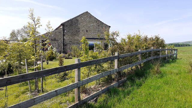
Home Plantation is a picturesque woodland located in the Yorkshire region of England. Situated in the heart of the county, it is a popular destination for nature enthusiasts and those seeking a tranquil retreat from the bustling city life.

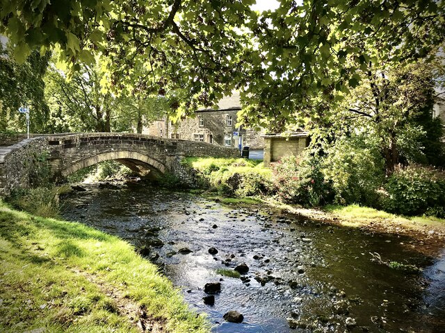
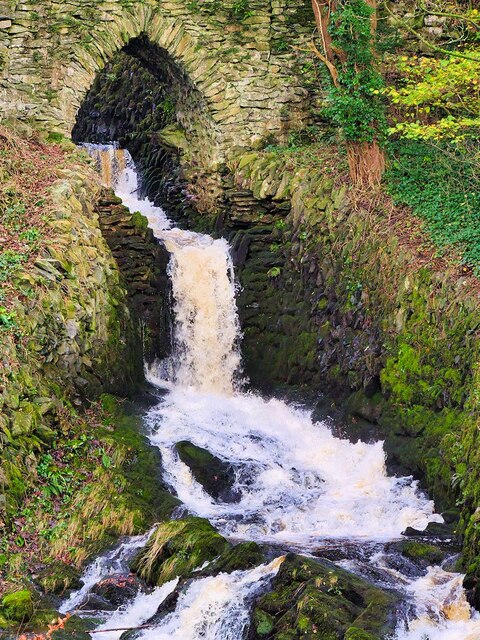
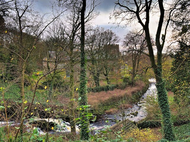
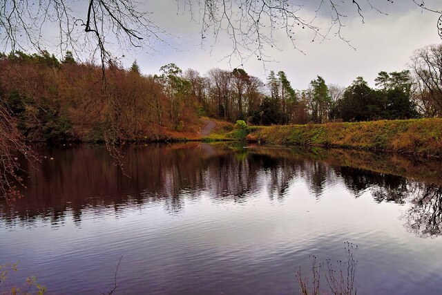
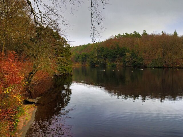
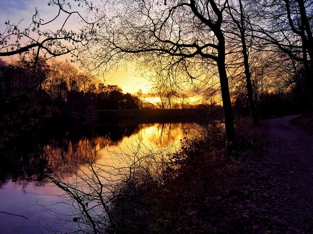
Covering an expansive area, Home Plantation boasts a diverse range of indigenous trees and flora, creating a stunning natural landscape. The woodland is primarily composed of oak, beech, and birch trees, intermingled with patches of vibrant wildflowers during the spring and summer months.

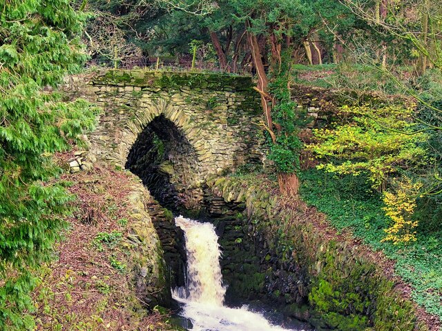
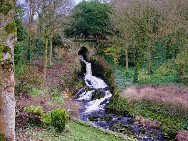
Home Plantation offers a myriad of walking trails and pathways, allowing visitors to explore its beauty at their own pace. These well-maintained trails wind through the forest, offering glimpses of enchanting streams, small ponds, and gentle slopes. The forest floor is adorned with a rich carpet of moss and ferns, further adding to the magical ambiance of the woodland.

As a haven for wildlife, Home Plantation is home to a variety of species. Birdwatchers can spot woodpeckers, owls, and various songbirds flitting between the tree branches. Squirrels can be seen scampering along the trunks, while deer occasionally grace the forest with their presence.

The plantation provides a peaceful escape for visitors, with several picnic areas and benches strategically placed throughout the woodland. These areas offer an opportunity to relax and soak in the natural surroundings, while listening to the soothing sounds of birdsong and rustling leaves.

Overall, Home Plantation in Yorkshire is a captivating destination for those seeking solace in nature. With its stunning scenery, diverse flora and fauna, and tranquil atmosphere, it is a true gem nestled within the county's landscape.

If you have any feedback on the listing, please let us know in the comments section below.

Home Plantation Images

Images are sourced within 2km of 54.119128/-2.3853296 or Grid Reference SD7469. Thanks to Geograph Open Source API. All images are credited.

Clapham Bridge
Clapham Bridge
Bridge over Clapham Beck Waterfall Clapham Falls is a man-made waterfall which sees Clapham Beck drop below a bridge, in  three separate tiers, from the lake above into Clapham itself. The waterfall was constructed in 1837 by Oliver and James William Farrar as part of the remodelling of the estate of Ingleborough Hall.
Bridge over Clapham Beck Waterfall
Clapham Falls is a man-made waterfall which sees Clapham Beck drop below a bridge, in three separate tiers, from the lake above into Clapham itself. The waterfall was constructed in 1837 by Oliver and James William Farrar as part of the remodelling of the estate of Ingleborough Hall.
St James' Church, Clapham Looking across Clapham Beck towards the Church of St James at Clapham. 
The majority of the current church dates from 1814 although the tower has been retained from an earlier, fifteenth century, church. It is a Grade II listed building (List Entry Number: 1132398 <span class="nowrap"><a title="https://historicengland.org.uk/listing/the-list/list-entry/1132398" rel="nofollow ugc noopener" href="https://historicengland.org.uk/listing/the-list/list-entry/1132398">Link</a><img style="margin-left:2px;" alt="External link" title="External link - shift click to open in new window" src="https://s1.geograph.org.uk/img/external.png" width="10" height="10"/></span> Historic England)
St James' Church, Clapham
Looking across Clapham Beck towards the Church of St James at Clapham. The majority of the current church dates from 1814 although the tower has been retained from an earlier, fifteenth century, church. It is a Grade II listed building (List Entry Number: 1132398 LinkExternal link Historic England)
Clapham Falls Clapham Falls is a man-made waterfall which sees Clapham Beck drop below a bridge, in  three separate tiers, from the lake above into Clapham itself. The waterfall was constructed in 1837 by Oliver and James William Farrar as part of the remodelling of the estate of Ingleborough Hall.
Clapham Falls
Clapham Falls is a man-made waterfall which sees Clapham Beck drop below a bridge, in three separate tiers, from the lake above into Clapham itself. The waterfall was constructed in 1837 by Oliver and James William Farrar as part of the remodelling of the estate of Ingleborough Hall.
Clapham Beck Waterfall Clapham Falls is a man-made waterfall which sees Clapham Beck drop below a bridge, in  three separate tiers, from the lake above into Clapham itself. The waterfall was constructed in 1837 by Oliver and James William Farrar as part of the remodelling of the estate of Ingleborough Hall.
Clapham Beck Waterfall
Clapham Falls is a man-made waterfall which sees Clapham Beck drop below a bridge, in three separate tiers, from the lake above into Clapham itself. The waterfall was constructed in 1837 by Oliver and James William Farrar as part of the remodelling of the estate of Ingleborough Hall.
Clapham Beck and the Church of St James Looking across Clapham Beck towards the Church of St James at Clapham. 
The majority of the current church dates from 1814 although the tower has been retained from an earlier, fifteenth century, church. It is a Grade II listed building (List Entry Number: 1132398 <span class="nowrap"><a title="https://historicengland.org.uk/listing/the-list/list-entry/1132398" rel="nofollow ugc noopener" href="https://historicengland.org.uk/listing/the-list/list-entry/1132398">Link</a><img style="margin-left:2px;" alt="External link" title="External link - shift click to open in new window" src="https://s1.geograph.org.uk/img/external.png" width="10" height="10"/></span> Historic England)
Clapham Beck and the Church of St James
Looking across Clapham Beck towards the Church of St James at Clapham. The majority of the current church dates from 1814 although the tower has been retained from an earlier, fifteenth century, church. It is a Grade II listed building (List Entry Number: 1132398 LinkExternal link Historic England)
Clapham Lake Clapham Lake is a man-made ornamental lake in Clapdale, just above the village of Clapham. It is surrounded by woodland and is seen here from Clapdale Drive, a wide track that passes along the western side of the lake on its through Clapdale Wood towards Ingleborough Cave.

Known simply as The Lake, this artificial lake was constructed in the 18th century as part of the remodelling of the Ingleborough estate by the Farrar family who built a dam to hold back the waters of Clapham Beck, which drains via the artificial watercourse of Clapham Falls.
Clapham Lake
Clapham Lake is a man-made ornamental lake in Clapdale, just above the village of Clapham. It is surrounded by woodland and is seen here from Clapdale Drive, a wide track that passes along the western side of the lake on its through Clapdale Wood towards Ingleborough Cave. Known simply as The Lake, this artificial lake was constructed in the 18th century as part of the remodelling of the Ingleborough estate by the Farrar family who built a dam to hold back the waters of Clapham Beck, which drains via the artificial watercourse of Clapham Falls.
Lake at Clapham Known simply as The Lake, this artificial lake, just above the village of Clapham, was constructed in the 18th century as part of the remodelling of the Ingleborough estate by the Farrar family who built a dam to hold back the waters of Clapham Beck, which drains via the artificial watercourse of Clapham Falls.

The ornamental lake is surrounded by woodland and is seen here from Clapdale Drive, a wide track that passes along the western side of the lake on its through Clapdale Wood towards Ingleborough Cave.
Lake at Clapham
Known simply as The Lake, this artificial lake, just above the village of Clapham, was constructed in the 18th century as part of the remodelling of the Ingleborough estate by the Farrar family who built a dam to hold back the waters of Clapham Beck, which drains via the artificial watercourse of Clapham Falls. The ornamental lake is surrounded by woodland and is seen here from Clapdale Drive, a wide track that passes along the western side of the lake on its through Clapdale Wood towards Ingleborough Cave.
Cat Hole Sike The shallow streambed that passes beneath Clapdale Drive is called Cat Hole Syke. ("Syke" or "sike" is a colloquial term for a small stream). The steeply dipping Ordovician rocks, some more than 400 million years old, were pushed to the surface by a major disturbance in the earth's crust which caused massive earth movements tilting them to their present angle. This is part of the Craven Fault System <span class="nowrap"><a title="https://en.wikipedia.org/wiki/Craven_Fault_System" rel="nofollow ugc noopener" href="https://en.wikipedia.org/wiki/Craven_Fault_System">Link</a><img style="margin-left:2px;" alt="External link" title="External link - shift click to open in new window" src="https://s1.geograph.org.uk/img/external.png" width="10" height="10"/></span> .
Cat Hole Sike
The shallow streambed that passes beneath Clapdale Drive is called Cat Hole Syke. ("Syke" or "sike" is a colloquial term for a small stream). The steeply dipping Ordovician rocks, some more than 400 million years old, were pushed to the surface by a major disturbance in the earth's crust which caused massive earth movements tilting them to their present angle. This is part of the Craven Fault System LinkExternal link .
The Lake, Clapham Known simply as The Lake, this artificial lake, just above the village of Clapham, was constructed in the 18th century as part of the remodelling of the Ingleborough estate by the Farrar family who built a dam to hold back the waters of Clapham Beck, which drains via the artificial watercourse of Clapham Falls.

The ornamental lake is surrounded by woodland and is seen here from Clapdale Drive, a wide track that passes along the western side of the lake on its route through Clapdale Wood towards Ingleborough Cave.
The Lake, Clapham
Known simply as The Lake, this artificial lake, just above the village of Clapham, was constructed in the 18th century as part of the remodelling of the Ingleborough estate by the Farrar family who built a dam to hold back the waters of Clapham Beck, which drains via the artificial watercourse of Clapham Falls. The ornamental lake is surrounded by woodland and is seen here from Clapdale Drive, a wide track that passes along the western side of the lake on its route through Clapdale Wood towards Ingleborough Cave.
Benchmark on Calter Barn Ordnance Survey cut mark benchmark levelled at 138.132m verified 1953
Benchmark on Calter Barn
Ordnance Survey cut mark benchmark levelled at 138.132m verified 1953
Benchmark on Calterber Bridge Ordnance Survey cut mark benchmark levelled at 128.101m above Newlyn Datum verified 1953
Benchmark on Calterber Bridge
Ordnance Survey cut mark benchmark levelled at 128.101m above Newlyn Datum verified 1953
SE face of Calterber Bridge There is an Ordnance Survey benchmark <a href="https://www.geograph.org.uk/photo/7500003">SD7367 : Benchmark on Calterber Bridge</a>  on the bridge arch on far side of river
SE face of Calterber Bridge
There is an Ordnance Survey benchmark SD7367 : Benchmark on Calterber Bridge on the bridge arch on far side of river
Calter Barn, a barn conversion on NW side of road Quite a change for the building since the 2016 geograph <a href="https://www.geograph.org.uk/photo/4317381">SD7368 : Calterber Barn</a>! There is an Ordnance Survey benchmark <a href="https://www.geograph.org.uk/photo/7499977">SD7368 : Benchmark on Calter Barn</a> on the right hand corner of house
Calter Barn, a barn conversion on NW side of road
Quite a change for the building since the 2016 geograph SD7368 : Calterber Barn! There is an Ordnance Survey benchmark SD7368 : Benchmark on Calter Barn on the right hand corner of house
Fields north of Calter Barn Ingleborough on the horizon
Fields north of Calter Barn
Ingleborough on the horizon
Old milestone This West Riding CC milestone dating from 1893/94 is west of Clapham, just west of a road sign.   It is now sunken into a hole.   The legends are - On the lhs - KENDAL/22 MILES.   On the rhs - SETTLE/7¼ MILES/SKIPTON/22¾ MILES/KEIGHLEY/32 MILES.   The foundry name on the bevel is WILLIAM TOWLER/GLOBE FOUNDRY/LEEDS.
Old milestone
This West Riding CC milestone dating from 1893/94 is west of Clapham, just west of a road sign. It is now sunken into a hole. The legends are - On the lhs - KENDAL/22 MILES. On the rhs - SETTLE/7¼ MILES/SKIPTON/22¾ MILES/KEIGHLEY/32 MILES. The foundry name on the bevel is WILLIAM TOWLER/GLOBE FOUNDRY/LEEDS.
View in direction of Crina Bottom Farm from road at Calter Barn
Church Avenue, Clapham Looking northward.
Church Avenue, Clapham
Looking northward.
Show me another place!

Home Plantation is located at Grid Ref: SD7469 (Lat: 54.119128, Lng: -2.3853296)

Division: West Riding

Administrative County: North Yorkshire

District: Craven

Police Authority: North Yorkshire

What 3 Words

///bins.prosper.confused. Near Ingleton, North Yorkshire

Related Wikis

Clapham, North Yorkshire

Clapham is a village in the civil parish of Clapham cum Newby in the Craven district of North Yorkshire, England. It was previously in the West Riding...

Clapham cum Newby

Clapham cum Newby is a civil parish in the Craven district of North Yorkshire, England. It was formerly in the Settle Rural District. It contains the villages...

Norber erratics

The Norber erratics are one of the finest groups of glacial erratic boulders in Britain. They are found on the southern slopes of Ingleborough, close to...
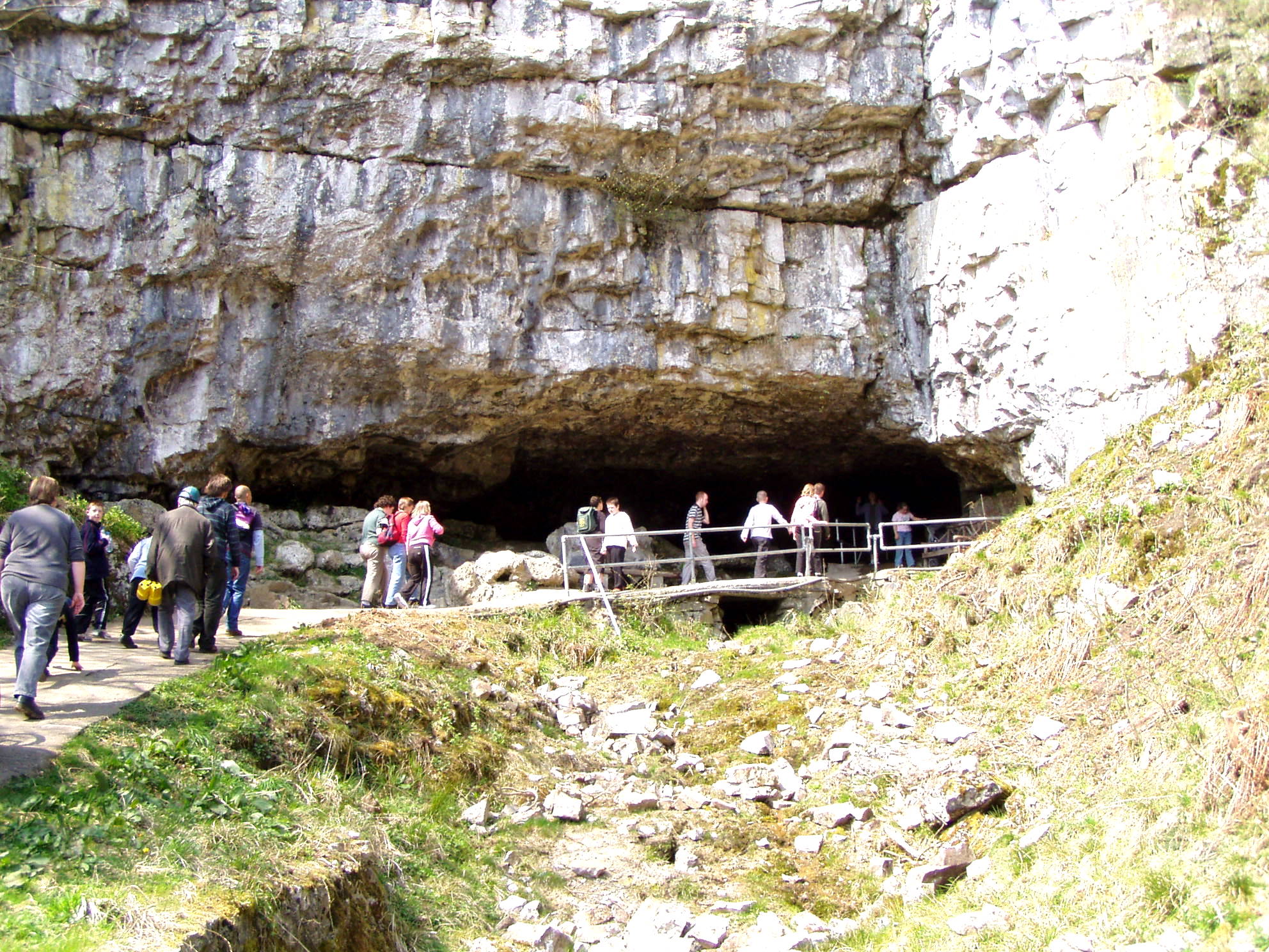
Ingleborough Cave

Ingleborough Cave (formerly known as Clapham Caves) is a show cave close to the village of Clapham in North Yorkshire, England, adjacent to where the water...

Austwick

Austwick is a village and civil parish in the Craven district of North Yorkshire, England, about 5 miles (8 km) north-west of Settle. The village is on...
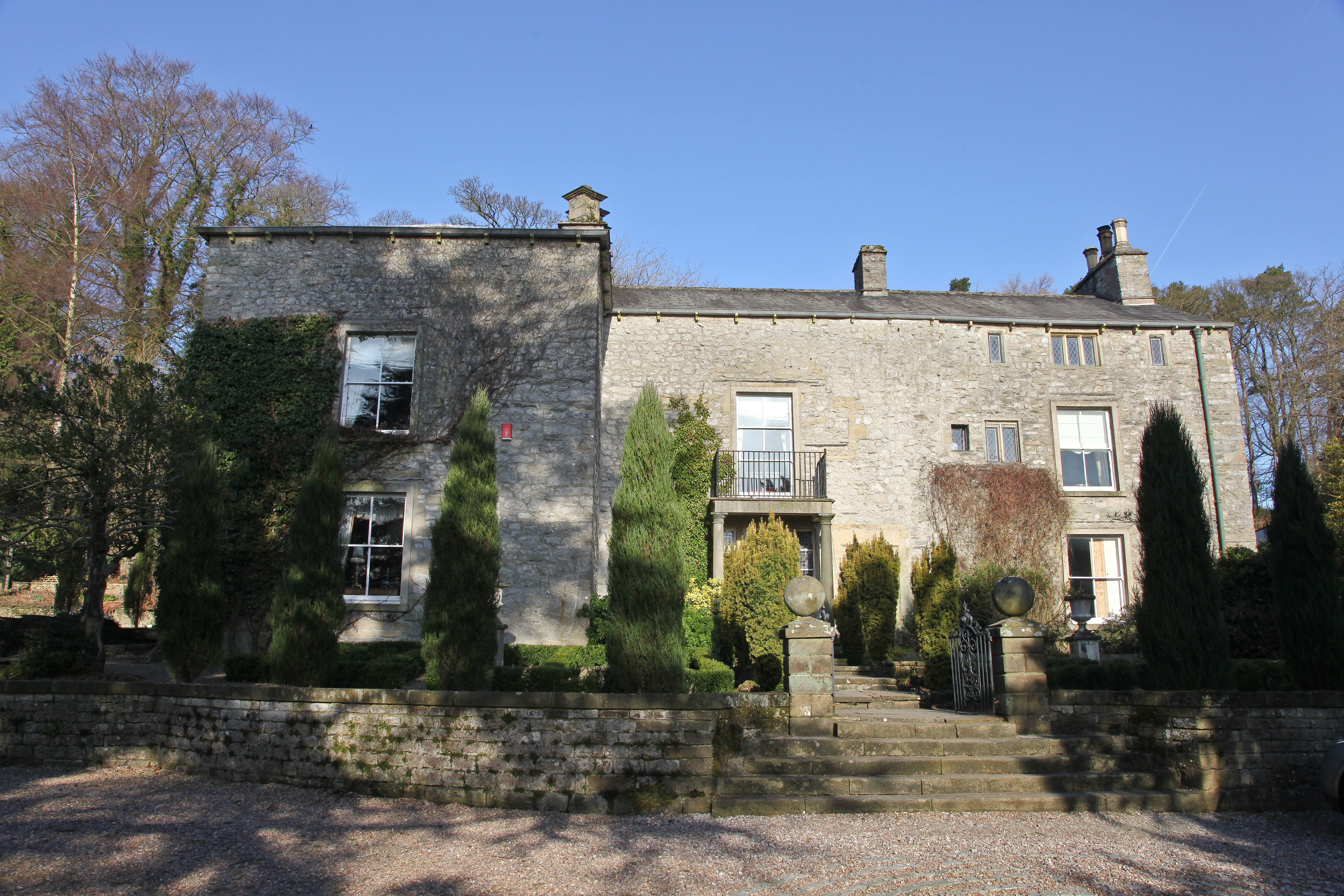
Austwick Hall

Austwick Hall is an historic manor house situated above the village of Austwick in North Yorkshire, England. The house is a Grade II listed building and...

Clapham railway station

Clapham is a railway station on the Bentham Line, which runs between Leeds and Morecambe via Skipton. The station, situated 48 miles (77 km) north-west...

Bar Pot

Bar Pot is one of the entrances to the Gaping Gill cave system being located about 340 metres (370 yd) south of Gaping Gill Main Shaft, on Ingleborough...

Nearby Amenities

Located within 500m of 54.119128,-2.3853296
Ingleborough Nature Trail
Tourism: attraction
Lat/Long: 54.1230254/-2.3845232
Clapham
Place: village
Source: survey and landsat
Wikidata: Q986042
Wikipedia: en:Clapham, North Yorkshire
Lat/Long: 54.1173621/-2.3921874
Barrier: stile
Lat/Long: 54.1174957/-2.3901975
Barrier: kissing_gate
Material: metal
Source: survey,gps
Lat/Long: 54.1166706/-2.3852028
Barrier: kissing_gate
Source: survey;gps
Lat/Long: 54.115427/-2.3818099
Clapham Village Store
Addr City: Clapham
Addr Postcode: LA2 8DP
Addr Street: Station Road
Image: https://www.geograph.org.uk/photo/5481148
Shop: convenience
Website: https://claphamvillagestore.co.uk/
Lat/Long: 54.1175413/-2.392454
Cafe
Croft Cafe
Addr City: Lancaster
Addr Country: GB
Addr Hamlet: Clapham
Addr Housename: Fellside
Addr Postcode: LA2 8EA
Addr Street: The Green
Fhrs Id: 292359
Fixme: Extant?
Fixme Addr2: Church Avenue
Source Addr: FHRS Open Data
Wheelchair: limited
Lat/Long: 54.1174488/-2.3915166
Telephone
Booth: KX100
Covered: booth
Lat/Long: 54.1172485/-2.3916923
Post Box
Collection Times: Mo-Fr 16:00, Sa 11:00
Post Box Type: pillar
Ref: LA2 92
Royal Cypher: EIIR
Royal Cypher Wikidata: Q33102113
Lat/Long: 54.1174891/-2.3924419
Clapham Falls
Image: https://www.geograph.org.uk/photo/7353623
Tourism: attraction
Waterway: waterfall
Lat/Long: 54.1206146/-2.3890631
Barrier: kissing_gate
Source: survey;gps
Lat/Long: 54.1171636/-2.3881141
Barrier: kissing_gate
Source: survey;gps
Lat/Long: 54.1173743/-2.3907616
Clapdale Drive
Description: Private reserve
Disused Barrier: toll_booth
Lat/Long: 54.1209221/-2.3905703
Defibrillator
Emergency: defibrillator
Indoor: no
Location: outside Cave Rescue, Church Lane Clapham
Lat/Long: 54.1172972/-2.3916353
Access: no
Barrier: stile
Foot: yes
Lat/Long: 54.1204144/-2.3841018
Bus Stop
Station Road
Naptan AtcoCode: 3200YNE04720
Naptan Bearing: NW
Naptan BusStopType: CUS
Naptan CommonName: Station Road
Naptan Indicator: NW-bound
Naptan Landmark: Bridge Cottage
Naptan LocalityCode: E0048881
Naptan NaptanCode: 32004720
Naptan Street: B6480
Naptan Verified: no
Public Transport: platform
Ref: 32004720
Lat/Long: 54.1173956/-2.3924
Station Road
Bus: yes
Public Transport: stop_position
Lat/Long: 54.1174327/-2.3923702
Bus Stop
New Inn
Naptan AtcoCode: 3200YNE04719
Naptan Bearing: SE
Naptan BusStopType: CUS
Naptan CommonName: New Inn
Naptan Indicator: SE-bound
Naptan Landmark: Bridge
Naptan LocalityCode: E0048881
Naptan NaptanCode: 32004719
Naptan Street: B6480
Naptan Verified: no
Public Transport: platform
Ref: 32004719
Lat/Long: 54.117049/-2.391848
New Inn
Bus: yes
Public Transport: stop_position
Lat/Long: 54.1170606/-2.3919293
Give Way
Direction: backward
Lat/Long: 54.120075/-2.392749
Generator Method: photovoltaic
Generator Orientation: west
Generator Output Electricity: yes
Generator Solar Modules: 8
Generator Source: solar
Generator Type: solar_photovoltaic_panel
Location: roof
Power: generator
Lat/Long: 54.1165406/-2.3912004
Generator Method: photovoltaic
Generator Orientation: west
Generator Output Electricity: yes
Generator Solar Modules: 8
Generator Source: solar
Generator Type: solar_photovoltaic_panel
Location: roof
Power: generator
Lat/Long: 54.1165406/-2.3911226
Generator Method: photovoltaic
Generator Orientation: west
Generator Output Electricity: yes
Generator Solar Modules: 8
Generator Source: solar
Generator Type: solar_photovoltaic_panel
Location: roof
Power: generator
Lat/Long: 54.1164934/-2.3910126
Generator Method: photovoltaic
Generator Orientation: west
Generator Output Electricity: yes
Generator Solar Modules: 8
Generator Source: solar
Generator Type: solar_photovoltaic_panel
Location: roof
Power: generator
Lat/Long: 54.116418/-2.3907096
Generator Method: photovoltaic
Generator Orientation: west
Generator Output Electricity: yes
Generator Solar Modules: 8
Generator Source: solar
Generator Type: solar_photovoltaic_panel
Location: roof
Power: generator
Lat/Long: 54.1164101/-2.3906505
Generator Method: photovoltaic
Generator Orientation: west
Generator Output Electricity: yes
Generator Solar Modules: 8
Generator Source: solar
Generator Type: solar_photovoltaic_panel
Location: roof
Power: generator
Lat/Long: 54.1163739/-2.3905594
Generator Method: photovoltaic
Generator Orientation: west
Generator Output Electricity: yes
Generator Solar Modules: 8
Generator Source: solar
Generator Type: solar_photovoltaic_panel
Location: roof
Power: generator
Lat/Long: 54.1163724/-2.3905138
Generator Method: photovoltaic
Generator Orientation: west
Generator Output Electricity: yes
Generator Solar Modules: 20
Generator Source: solar
Generator Type: solar_photovoltaic_panel
Location: roof
Power: generator
Lat/Long: 54.1187822/-2.3928604
Charging Station
Access: yes
Authentication App: yes
Capacity: 2
Fee: yes
Motorcar: yes
Network: podpoint
Opening Hours: 24/7
Operator: Yorkshire Dales National Park
Parking Fee: yes
Payment App: yes
Ref: Rhys-Zara
Socket Type2: 2
Socket Type2 Output: 22kW
Lat/Long: 54.1178269/-2.3906636
Vending Machine
Vending: parking_tickets
Lat/Long: 54.1181016/-2.3908777
Information: board
Tourism: information
Lat/Long: 54.1181016/-2.3910531
Entrance: main
Lat/Long: 54.1200048/-2.3924281
Cafe
Tea room
Addr City: Lancaster
Addr Postcode: LA2 8DZ
Addr Street: Cross Haw Lane
Addr Suburb: Clapham
Cuisine: tea;coffee_shop;cake;soft_drink
Lat/Long: 54.1199917/-2.3924728
Fixme: continues?
Lat/Long: 54.1214913/-2.3914569
Clapham Millennium Stone
Artwork Type: sculpture
Image: https://www.geograph.org.uk/photo/4748094
Tourism: artwork
Lat/Long: 54.1180848/-2.3905731
Market Cross
Image: https://www.geograph.org.uk/photo/4748092
Man Made: cross
Wikidata: Q17647492
Lat/Long: 54.117575/-2.3916896
Give Way
Direction: forward
Lat/Long: 54.1202288/-2.3913221
Rhondodendrons
Board Type: plants
Fixme: Confirm exact location
Information: board
Tourism: information
Lat/Long: 54.1235246/-2.3842478
Nature
Board Type: nature
Information: board
Tourism: information
Lat/Long: 54.1223119/-2.3855875
Life Saving Equipment
Emergency: life_saving_equipment
Life Saving Equipment: life_line
Lat/Long: 54.1216438/-2.3892863
Bench
Backrest: yes
Lat/Long: 54.1216415/-2.3893359
The Lake
Board Type: history
Information: board
Tourism: information
Lat/Long: 54.1216045/-2.3892219
Reginald John Farrar
Board Type: history
Information: board
Tourism: information
Lat/Long: 54.1213664/-2.3905429
Parking
Disabled Car Parking
Access: customers
Operator: Ingleborough Estate
Parking: street_side
Lat/Long: 54.1208496/-2.3905704
The Clapham Conservation Project
Information: board
Tourism: information
Lat/Long: 54.1206468/-2.3907394
Historic: boundary_stone
Image: https://www.geograph.org.uk/photo/5832730
Lat/Long: 54.1202626/-2.3912416
Image: https://www.geograph.org.uk/photo/5832760
Information: guidepost
Tourism: information
Lat/Long: 54.1202719/-2.3912343
Fountain
Drinking Water: no
Website: https://www.geograph.org.uk/photo/1417795
Lat/Long: 54.1174642/-2.3920872
Entrance: main
Lat/Long: 54.1201957/-2.3905382
The data included in this document is from www.openstreetmap.org. The data is made available under ODbL.

Have you been to Home Plantation?

Leave your review of Home Plantation below (or comments, questions and feedback).