Gisburn Forest

Wood, Forest in Yorkshire Ribble Valley

England

Gisburn Forest

River Hodder entering Stocks Reservoir The photo shows the point at which the River Hodder enters the Stocks Reservoir. The reservoir is at a particularly low level. It was opened in 1932 and supplies Blackpool and the Fylde coast. There are a number of waymarked forest walks and cycle routes. Trout fishing is available.
River Hodder entering Stocks Reservoir Credit: Rod Grealish

Gisburn Forest, located in the county of Yorkshire, England, is a picturesque woodland area that spans approximately 3,000 acres. Situated in the Ribble Valley, Gisburn Forest is renowned for its natural beauty and diverse range of flora and fauna.

The forest is predominantly composed of coniferous trees, such as pine and spruce, which provide a dense and enchanting canopy. Walking through Gisburn Forest, visitors are greeted with a serene and peaceful atmosphere, surrounded by the soothing sounds of rustling leaves and chirping birds.

The forest offers a variety of trails and paths that cater to different levels of difficulty, making it an ideal destination for both casual walkers and experienced hikers. These well-maintained trails wind through the forest, offering stunning views of the surrounding countryside and glimpses of wildlife, including deer, squirrels, and a myriad of bird species.

In addition to its natural beauty, Gisburn Forest is also home to a thriving mountain biking community. The forest boasts an extensive network of purpose-built mountain biking trails, attracting enthusiasts from all over the country. These trails cater to different skill levels, ranging from gentle routes for beginners to challenging tracks for experienced riders.

For those seeking a break from outdoor activities, Gisburn Forest also offers picnic areas and a visitor center that provides information on the forest's history, wildlife, and conservation efforts. The center also houses a small café where visitors can enjoy a hot drink and a bite to eat.

Overall, Gisburn Forest is a haven for nature lovers, offering a tranquil escape from the hustle and bustle of everyday life. Its stunning landscapes, diverse wildlife, and recreational opportunities make it a must-visit destination in Yorkshire.

If you have any feedback on the listing, please let us know in the comments section below.

Gisburn Forest Images

Images are sourced within 2km of 54.003358/-2.388317 or Grid Reference SD7456. Thanks to Geograph Open Source API. All images are credited.

River Hodder entering Stocks Reservoir The photo shows the point at which the River Hodder enters the Stocks Reservoir. The reservoir is at a particularly low level. It was opened in 1932 and supplies Blackpool and the Fylde coast. There are a number of waymarked forest walks and cycle routes. Trout fishing is available.
River Hodder entering Stocks Reservoir
The photo shows the point at which the River Hodder enters the Stocks Reservoir. The reservoir is at a particularly low level. It was opened in 1932 and supplies Blackpool and the Fylde coast. There are a number of waymarked forest walks and cycle routes. Trout fishing is available.
Farming activity at Higher Ghylls Mid-June is always a busy time of year for farmers in this area.
Farming activity at Higher Ghylls
Mid-June is always a busy time of year for farmers in this area.
At Higher Ghylls The farm entrance is on the left-hand side of this shot, just before the bridge crossing Bond Beck.
At Higher Ghylls
The farm entrance is on the left-hand side of this shot, just before the bridge crossing Bond Beck.
Tosside, roadside wall This stretch of wall is on the south side of B6478 and to south-west of Tosside. According to the OS benchmark database there is a cutmark in the wall at this location. The verge growth was too dense to make a thorough search.
Tosside, roadside wall
This stretch of wall is on the south side of B6478 and to south-west of Tosside. According to the OS benchmark database there is a cutmark in the wall at this location. The verge growth was too dense to make a thorough search.
Tosside, roadside wall The rivet benchmark is cut into the wall on the south side of B6478.
Tosside, roadside wall
The rivet benchmark is cut into the wall on the south side of B6478.
Tosside, B6478 There is a rivet benchmark cut into the wall on the south side of B6478. The mark is just in front of this tree beside the wall.
Tosside, B6478
There is a rivet benchmark cut into the wall on the south side of B6478. The mark is just in front of this tree beside the wall.
Tosside, Bond Beck bridge According to the OS benchmark database there is a benchmark cut into the south-east parapet. Nothing was found.
Tosside, Bond Beck bridge
According to the OS benchmark database there is a benchmark cut into the south-east parapet. Nothing was found.
Tosside, roadside wall The rivet benchmark is cut into the road side wall on the north side of B6478 and to the west of Bond Beck bridge.
Tosside, roadside wall
The rivet benchmark is cut into the road side wall on the north side of B6478 and to the west of Bond Beck bridge.
Tosside, roadside wall There is a rivet benchmark cut into the roadside wall on the north side of B6478 and to the west of Bond Beck bridge.
Tosside, roadside wall
There is a rivet benchmark cut into the roadside wall on the north side of B6478 and to the west of Bond Beck bridge.
Tosside, Brock Thorn Laithe The damaged benchmark is cut into a boundary stone in the east facing wall of Brock Thorn Laithe.
Tosside, Brock Thorn Laithe
The damaged benchmark is cut into a boundary stone in the east facing wall of Brock Thorn Laithe.
Tosside, Brock Thorn Laithe There is a damaged benchmark cut into a boundary stone which is fixed into the east facing wall of Brock Thorn Laithe.
Tosside, Brock Thorn Laithe
There is a damaged benchmark cut into a boundary stone which is fixed into the east facing wall of Brock Thorn Laithe.
Tosside, Marl Barn According to the OS benchmark database there was a cutmark in one of the gateposts at this location. The entrance has been widened with new wooden gateposts. There is also a new entrance to the left of this field entrance. The gateposts were checked but had no marks.
Tosside, Marl Barn
According to the OS benchmark database there was a cutmark in one of the gateposts at this location. The entrance has been widened with new wooden gateposts. There is also a new entrance to the left of this field entrance. The gateposts were checked but had no marks.
Tosside, B6478 The benchmark is cut into a right hand gatepost at a field entrance on the north side of the road.
Tosside, B6478
The benchmark is cut into a right hand gatepost at a field entrance on the north side of the road.
Tosside, B6478 There is a benchmark cut into the right hand gatepost at the field entrance on the north side of the road.
Tosside, B6478
There is a benchmark cut into the right hand gatepost at the field entrance on the north side of the road.
Tosside, B6478 The benchmark is cut into the roadside wall on the north side of the road, and the mark is directly at a wall junction which splits the fields.
Tosside, B6478
The benchmark is cut into the roadside wall on the north side of the road, and the mark is directly at a wall junction which splits the fields.
Tosside, B6478 There is a benchmark cut into the roadside wall on the north side of the road, and the mark is directly at a wall junction which splits the fields.
Tosside, B6478
There is a benchmark cut into the roadside wall on the north side of the road, and the mark is directly at a wall junction which splits the fields.
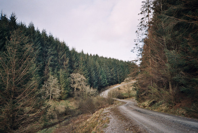
Gisburn Forest track A left turn to the north makes this easy-going teack a little harder as it is now gently uphill. Most of the forestry tracks are like this - low gradient and not too challenging for those on mountain bikes so old that suspension was not deemed necessary (at my age I want all the power I can generate to go into actual forward progress, not into compressing shock absorbers).
Gisburn Forest track
A left turn to the north makes this easy-going teack a little harder as it is now gently uphill. Most of the forestry tracks are like this - low gradient and not too challenging for those on mountain bikes so old that suspension was not deemed necessary (at my age I want all the power I can generate to go into actual forward progress, not into compressing shock absorbers).
Looking over Bottoms Beck A gap in the trees to the east of the track allows a view over Bottoms Beck to the clearing morning mists towards Hesbert Hall.
Looking over Bottoms Beck
A gap in the trees to the east of the track allows a view over Bottoms Beck to the clearing morning mists towards Hesbert Hall.
Show me another place!

Gisburn Forest is located at Grid Ref: SD7456 (Lat: 54.003358, Lng: -2.388317)

Division: West Riding

Administrative County: Lancashire

District: Ribble Valley

Police Authority: Lancashire

What 3 Words

///posts.districts.rainfall. Near Settle, North Yorkshire

Nearby Locations

Park Wood Gisburn Forest

Related Wikis

Easington, Lancashire

Easington () is a civil parish within the Ribble Valley district of Lancashire, England, with a population in 2001 of 52. The Census 2011 population details...

Stocks Reservoir

Stocks Reservoir is a reservoir situated at the head of the Hodder valley in the Forest of Bowland, Lancashire, England (historically in the West Riding...

Tosside

Tosside is a small village on the modern border of North Yorkshire and Lancashire in Northern England. It lies within the Forest of Bowland, and is between...

Gisburn Forest

Gisburn Forest is a civil parish in the Ribble Valley, in Lancashire, England. Mainly lying within the Forest of Bowland Area of Outstanding Natural Beauty...

Nearby Amenities

Located within 500m of 54.003358,-2.388317
Bicycle Rental
Gisburn Forest Hub
Lat/Long: 53.9993664/-2.3895425
Cafe
Gisburn Forest Hub
Addr City: Clitheroe
Addr Hamlet: Stephen Park
Addr Place: Slaidburn
Addr Postcode: BB7 4TS
Addr Street: Hole House Lane
Fhrs Id: 903445
Payment Cash: yes
Payment Credit Cards: no
Payment Debit Cards: no
Source Addr: FHRS Open Data
Lat/Long: 53.9993065/-2.3894781
Leisure: picnic_table
Source: survey
Lat/Long: 53.9993522/-2.389808
Leisure: picnic_table
Source: survey
Lat/Long: 53.9993585/-2.3897302
Leisure: picnic_table
Source: survey
Lat/Long: 53.9993901/-2.3903874
Leisure: picnic_table
Source: survey
Lat/Long: 53.9994042/-2.3906153
The data included in this document is from www.openstreetmap.org. The data is made available under ODbL.

Have you been to Gisburn Forest?

Leave your review of Gisburn Forest below (or comments, questions and feedback).