Cowden

Settlement in Perthshire

Scotland

Cowden

Drumchork Wood
Drumchork Wood Credit: Richard Webb

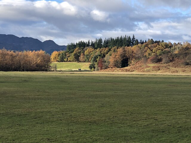
Cowden is a small village located in the county of Perthshire, Scotland. Situated about 5 miles south of the town of Auchterarder, Cowden is nestled in the picturesque countryside, surrounded by rolling hills and farmland.

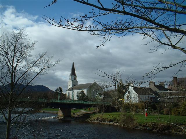
The village is home to a close-knit community, with a population of around 200 residents. The main focal point of Cowden is the St. Mungo's Church, a historic building dating back to the 18th century. The church serves as a gathering place for local residents and hosts various community events throughout the year.

One of the notable features of Cowden is its beautiful natural surroundings. The village is surrounded by vast green fields and is close to the Ochil Hills, providing ample opportunities for outdoor activities such as hiking, cycling, and horseback riding. The nearby Glen Eagles Golf Course, one of Scotland's most prestigious golfing destinations, is also a popular attraction for both locals and tourists.

Despite being a small village, Cowden has a few amenities to offer its residents. There is a local pub, The Cowden Inn, where locals can gather for a drink or a meal. Additionally, there is a primary school located within the village for the education of the local children.

Overall, Cowden is a charming village that offers a peaceful and idyllic setting for its residents. With its natural beauty and sense of community, it is a place that attracts those seeking a quieter and more rural lifestyle.

If you have any feedback on the listing, please let us know in the comments section below.

Cowden Images

Images are sourced within 2km of 56.356291/-3.9922142 or Grid Reference NN7720. Thanks to Geograph Open Source API. All images are credited.

Drumchork Wood
Drumchork Wood
Edge of Cowden Wood Cowden Wood is mostly coniferous, but there is evidence of previous oak coppicing. There were cattle grazing the adjacent field.
Edge of Cowden Wood
Cowden Wood is mostly coniferous, but there is evidence of previous oak coppicing. There were cattle grazing the adjacent field.
Summit area, Cowden Wood Windthrow to the east of the summit.
Summit area, Cowden Wood
Windthrow to the east of the summit.
Low Rainbow over Cultybraggan The main road through Cultybraggan Camp does not lead exactly towards the rainbow.
Low Rainbow over Cultybraggan
The main road through Cultybraggan Camp does not lead exactly towards the rainbow.
Farm road heading towards Dalrannoch Looking south-westward.
Farm road heading towards Dalrannoch
Looking south-westward.
Minor road at Auchingarrich Looking north-westward.
Minor road at Auchingarrich
Looking north-westward.
Fence and hedge-lined minor road near Easter Meiggar Looking north-eastward.
Fence and hedge-lined minor road near Easter Meiggar
Looking north-eastward.
Ordnance Survey Cut Mark with Rivet This mark and rivet can be found on the top of the parapet wall of a bridge spanning Auchingarrich Burn,
The recorded details give a height of 112.2548 metres above sea level.
For more detail see : <span class="nowrap"><a title="https://www.bench-marks.org.uk/bm179765" rel="nofollow ugc noopener" href="https://www.bench-marks.org.uk/bm179765">Link</a><img style="margin-left:2px;" alt="External link" title="External link - shift click to open in new window" src="https://s1.geograph.org.uk/img/external.png" width="10" height="10"/></span>
Ordnance Survey Cut Mark with Rivet
This mark and rivet can be found on the top of the parapet wall of a bridge spanning Auchingarrich Burn, The recorded details give a height of 112.2548 metres above sea level. For more detail see : LinkExternal link
B827 beneath Cowden Wood A long gentle climb out of Strath Earn.
B827 beneath Cowden Wood
A long gentle climb out of Strath Earn.
Duck pond, Auchingarich On the outside of a bend on the B827.
Duck pond, Auchingarich
On the outside of a bend on the B827.
Drumchork Very flat fields amongst hills. Former loch bed?
Drumchork
Very flat fields amongst hills. Former loch bed?
Entrance to Cultybraggan Camp
Track through field near Dalrannoch
Former Officers' Mess, Cultybraggan Camp Cultybraggan Camp was constructed in 1941 as a Prisoner of War camp. After the war it was used as a military training camp until decommissioning in 2004.

In 2007 the camp was brought by the Comrie Development Trust and is being developed into a variety of uses whilst keeping its original character. 26 of the Nissen huts are Category A listed by Historic Scotland.

For more info. see <span class="nowrap"><a title="http://www.secretscotland.org.uk/index.php/Secrets/Cultybraggan" rel="nofollow ugc noopener" href="http://www.secretscotland.org.uk/index.php/Secrets/Cultybraggan">Link</a><img style="margin-left:2px;" alt="External link" title="External link - shift click to open in new window" src="https://s1.geograph.org.uk/img/external.png" width="10" height="10"/></span> and <span class="nowrap"><a title="http://www.online-archaeology.co.uk/contribute/archaeologyarticles/tabid/85/articletype/articleview/articleid/11/default.aspx" rel="nofollow ugc noopener" href="http://www.online-archaeology.co.uk/contribute/archaeologyarticles/tabid/85/articletype/articleview/articleid/11/default.aspx">Link</a><img style="margin-left:2px;" alt="External link" title="External link - shift click to open in new window" src="https://s1.geograph.org.uk/img/external.png" width="10" height="10"/></span> and <span class="nowrap"><a title="http://www.28dayslater.co.uk/forums/showthread.php?p=365558" rel="nofollow ugc noopener" href="http://www.28dayslater.co.uk/forums/showthread.php?p=365558">Link</a><img style="margin-left:2px;" alt="External link" title="External link - shift click to open in new window" src="https://s1.geograph.org.uk/img/external.png" width="10" height="10"/></span>
Former Officers' Mess, Cultybraggan Camp
Cultybraggan Camp was constructed in 1941 as a Prisoner of War camp. After the war it was used as a military training camp until decommissioning in 2004. In 2007 the camp was brought by the Comrie Development Trust and is being developed into a variety of uses whilst keeping its original character. 26 of the Nissen huts are Category A listed by Historic Scotland. For more info. see LinkExternal link and LinkExternal link and LinkExternal link
Allotments, Cultybraggan Camp Allotments established in 2009 on the site of one of the four prisoner 'compounds' demolished in the 1970s to build an assault course and small arms firing range which can be seen in the distance (<a href="https://www.geograph.org.uk/gridref/NN7620">NN7620</a>).
Allotments, Cultybraggan Camp
Allotments established in 2009 on the site of one of the four prisoner 'compounds' demolished in the 1970s to build an assault course and small arms firing range which can be seen in the distance (NN7620).
Horse Gin House, Dalrannoch Horse gin houses date from the late 18th or early 19th century and housed a wheel or gin which was turned by a horse walking around in a circle. A belt from the wheel would have been fed into the adjacent barn to provide power for machinery such as a threshing machine.
Horse Gin House, Dalrannoch
Horse gin houses date from the late 18th or early 19th century and housed a wheel or gin which was turned by a horse walking around in a circle. A belt from the wheel would have been fed into the adjacent barn to provide power for machinery such as a threshing machine.
Auchingarrich Wildlife Centre
Show me another place!

Cowden is located at Grid Ref: NN7720 (Lat: 56.356291, Lng: -3.9922142)

Unitary Authority: Perth and Kinross

Police Authority: Tayside

What 3 Words

///prepped.history.unique. Near Comrie, Perth & Kinross

Nearby Locations

Cowden Wood Cowden

Related Wikis

Cultybraggan Camp

Cultybraggan Camp lies close to the village of Comrie, in west Perthshire, Scotland. It was first used as a prisoner of war (PoW) camp during World War...

1 Dunira Street

1 Dunira Street is an historic building in Comrie, Perth and Kinross, Scotland. It is a Category A listed building dating to 1904. Its architect was Charles...

Comrie, Perth and Kinross

Comrie (; Gaelic: Cuimridh; Pictish: Aberlednock; Latin: Victoria) is a village and parish in the southern Highlands of Scotland, towards the western end...

Aberuchill Castle

Aberuchill Castle is located 3 kilometres (1.9 mi) west of Comrie in Perthshire, Scotland. It comprises an early 17th-century tower house, which was extended...

Dalchonzie

Dalchonzie is a place by the river Earn in Perthshire. Buildings there include a country house, a hydro-electric power station and farms. From 1903 to...

Dalchonzie Halt railway station

Dalchonzie Halt railway station, Dalchonzie Platform railway station or Dalchonzie Siding in the Parish of Comrie, Perth and Kinross, Scotland was an intermediate...

Dunira, Perthshire

Dunira (Scottish Gaelic: Dùn Iar) is an estate of about 350 hectares (860 acres) in Perthshire, Scotland, 3 miles (5 kilometres) northwest of Comrie and...

Glen Artney

Glen Artney or Glenartney is a valley in Perthshire, Scotland.Several ships have been named Glenartney: SS Glenartney (1869), an iron-hulled steamship...

Nearby Amenities

Located within 500m of 56.356291,-3.9922142
Height: 9
Man Made: chimney
Lat/Long: 56.3576022/-3.9949006
Man Made: mast
Lat/Long: 56.3581047/-3.9946041
Give Way
Direction: forward
Lat/Long: 56.3567245/-3.9873776
Comrie ROC Underground Monitoring Post
Man Made: monitoring_station
Lat/Long: 56.3582585/-3.9940653
Power: pole
Source: Bing
Lat/Long: 56.3575855/-3.9957085
Historic: archaeological_site
Source: Bing
Lat/Long: 56.3592929/-3.9936546
Power: pole
Source: Bing
Lat/Long: 56.3558827/-3.9903715
Power: pole
Source: Bing
Lat/Long: 56.3564782/-3.9905238
Power: pole
Source: Bing
Lat/Long: 56.358022/-3.9912163
Power: pole
Source: Bing
Lat/Long: 56.3584843/-3.994014
Power: pole
Source: Bing
Lat/Long: 56.3587479/-3.9916623
Power: pole
Source: Bing
Lat/Long: 56.3589872/-3.9930252
Power: pole
Source: Bing
Lat/Long: 56.3594676/-3.9920861
Power: pole
Source: Bing
Lat/Long: 56.3529727/-3.9969179
Power: pole
Lat/Long: 56.3571402/-3.9906912
Power: pole
Source: Bing
Lat/Long: 56.3602101/-3.9925477
Power: pole
Source: Bing
Lat/Long: 56.3532383/-3.9944165
Note: power_line switches from overground to underground at this double pole.
Power: pole
Source: https://www.rettie.co.uk/site/includes/content/download_brochure.php?pcode=RUR150199#page3
Lat/Long: 56.3552629/-3.9902157
Power: pole
Source: Bing
Lat/Long: 56.356103/-3.999597
Power: pole
Source: Bing
Lat/Long: 56.3564654/-3.9985696
Power: pole
Source: Bing
Lat/Long: 56.3568177/-3.9975649
Power: pole
Source: Bing
Lat/Long: 56.3571828/-3.9965128
Barrier: kissing_gate
Lat/Long: 56.3537851/-3.9961149
Bicycle Parking
Access: yes
Capacity: 6
Covered: no
Fee: no
Survey Date: 2021-06-06
Lat/Long: 56.3552566/-3.9958588
Comrie Workspace
Office: coworking
Survey Date: 2021-06-06
Website: https://comrieworkspace.com/
Lat/Long: 56.3549385/-3.9956948
Barrier: cattle_grid
Lat/Long: 56.3545531/-3.9928186
Xtreme Emergency Training
Addr Housename: Unit 28
Addr Postcode: PH6 2AB
Office: yes
Website: https://www.xtremeemergencytraining.co.uk
Lat/Long: 56.3556709/-3.9936911
Bench
Lat/Long: 56.3554632/-3.9949673
Information: board
Source: survey
Tourism: information
Lat/Long: 56.3554769/-3.9949525
Strathearn Cheese
Addr Housename: 15B
Contact Facebook: https://www.facebook.com/StrathearnCheeseCo/
Shop: cheese
Lat/Long: 56.3551654/-3.9951333
Leisure: picnic_table
Lat/Long: 56.3550801/-3.9958061
Leisure: picnic_table
Lat/Long: 56.3553149/-3.995617
Leisure: picnic_table
Lat/Long: 56.3553387/-3.9955339
Information: board
Source: survey
Tourism: information
Lat/Long: 56.3554325/-3.9947996
Information: board
Source: survey
Tourism: information
Lat/Long: 56.3572326/-3.9955473
Information: board
Source: survey
Tourism: information
Lat/Long: 56.3568983/-3.9960864
Height: 0
Lat/Long: 56.3559495/-3.9952737
Height: 0
Lat/Long: 56.355935/-3.9953153
Height: 0
Lat/Long: 56.3559205/-3.9953569
Barrier: bollard
Source: survey
Lat/Long: 56.3561638/-3.9926934
Barrier: bollard
Source: survey
Lat/Long: 56.3561785/-3.9927119
Barrier: bollard
Source: survey
Lat/Long: 56.3561902/-3.9927243
Barrier: bollard
Source: survey
Lat/Long: 56.3562073/-3.9927384
Barrier: bollard
Source: survey
Lat/Long: 56.3562233/-3.9927571
Barrier: bollard
Source: survey
Lat/Long: 56.3562385/-3.9927705
Barrier: bollard
Source: survey
Lat/Long: 56.3562545/-3.9927886
Barrier: bollard
Source: survey
Lat/Long: 56.3562679/-3.9928027
Barrier: bollard
Source: survey
Lat/Long: 56.3562953/-3.9928438
Barrier: bollard
Source: survey
Lat/Long: 56.356313/-3.9928671
Information: board
Source: survey
Tourism: information
Lat/Long: 56.3564932/-3.9927229
Leisure: picnic_table
Lat/Long: 56.3565907/-3.992094
Men's Shed
Office: yes
Lat/Long: 56.356642/-3.992397
Grit Bin
Source: survey
Lat/Long: 56.357447/-3.9951094
Street Lamp
Lit: yes
Source: survey
Lat/Long: 56.3572508/-3.9956539
Street Lamp
Lit: yes
Source: survey
Lat/Long: 56.3571149/-3.9960824
Waste Basket
Lat/Long: 56.3566613/-3.9959382
Street Lamp
Lit: yes
Source: survey
Lat/Long: 56.3568782/-3.996187
Street Lamp
Lit: yes
Source: survey
Lat/Long: 56.3566665/-3.9959456
Information: board
Tourism: information
Lat/Long: 56.3564499/-3.9962497
Street Lamp
Lit: yes
Source: survey
Lat/Long: 56.3556556/-3.9948871
Street Lamp
Lit: yes
Source: survey
Lat/Long: 56.3559435/-3.9951839
Street Lamp
Lit: yes
Source: survey
Lat/Long: 56.3562006/-3.9954373
Street Lamp
Lit: yes
Source: survey
Lat/Long: 56.3564295/-3.9956868
Street Lamp
Lit: yes
Source: survey
Lat/Long: 56.3550794/-3.995668
Street Lamp
Lit: yes
Source: survey
Lat/Long: 56.3552287/-3.9958993
Waste Basket
Lat/Long: 56.3553278/-3.9956834
Access: yes
Barrier: lift_gate
Source: survey
Lat/Long: 56.3542844/-3.9925229
Information: board
Source: survey
Tourism: information
Lat/Long: 56.3560182/-3.9934532
Street Lamp
Lit: yes
Source: survey
Lat/Long: 56.3576279/-3.9944885
Street Lamp
Lit: yes
Source: survey
Lat/Long: 56.3575176/-3.9948231
Street Lamp
Lit: yes
Source: survey
Lat/Long: 56.3578137/-3.9939453
Street Lamp
Lit: yes
Source: survey
Lat/Long: 56.3579507/-3.9934357
Street Lamp
Lit: yes
Source: survey
Lat/Long: 56.3577327/-3.9931789
Street Lamp
Lit: yes
Source: survey
Lat/Long: 56.3574962/-3.9929191
Street Lamp
Lit: yes
Source: survey
Lat/Long: 56.3572672/-3.9926726
Street Lamp
Lit: yes
Source: survey
Lat/Long: 56.3570393/-3.9924192
Street Lamp
Lit: yes
Source: survey
Lat/Long: 56.3563878/-3.9918485
Street Lamp
Lit: yes
Source: survey
Lat/Long: 56.3562608/-3.9922576
Street Lamp
Lit: yes
Source: survey
Lat/Long: 56.3560869/-3.9926438
Street Lamp
Lit: yes
Source: survey
Lat/Long: 56.3559383/-3.9930756
Bench
Lat/Long: 56.3544575/-3.9922468
Street Lamp
Lit: yes
Source: survey
Lat/Long: 56.354511/-3.9928597
Street Lamp
Lit: yes
Source: survey
Lat/Long: 56.3542858/-3.9926183
Information: board
Tourism: information
Lat/Long: 56.3539819/-3.9923957
Street Lamp
Lit: yes
Source: survey
Lat/Long: 56.3540206/-3.9923447
Traffic Sign: stop
Lat/Long: 56.3548108/-3.993016
Man Made: planter
Source: survey
Lat/Long: 56.3547967/-3.9930649
Man Made: planter
Source: survey
Lat/Long: 56.3547892/-3.9930924
Street Lamp
Lit: yes
Source: survey
Lat/Long: 56.3549475/-3.993313
Street Lamp
Lit: yes
Source: survey
Lat/Long: 56.3547751/-3.99313
Recycling
Recycling Cardboard: information
Recycling Type: container
Lat/Long: 56.3546202/-3.9936037
Bench
Lat/Long: 56.3554149/-3.9943289
Bench
Lat/Long: 56.3554272/-3.9942927
Bench
Lat/Long: 56.3554572/-3.9943201
Bench
Lat/Long: 56.3554461/-3.9943624
Leisure: picnic_table
Lat/Long: 56.3553097/-3.9948754
Leisure: picnic_table
Lat/Long: 56.3552941/-3.9949317
Leisure: picnic_table
Lat/Long: 56.3551626/-3.9958826
Information: board
Source: survey
Tourism: information
Lat/Long: 56.3547144/-3.9931754
Information: board
Source: survey
Tourism: information
Lat/Long: 56.3562653/-3.9953649
Bogons Ltd
Addr Postcode: PH6 2AB
Office: yes
Website: https://www.bogons.net/
Lat/Long: 56.3578568/-3.9945338
Cultybraggan Bunker
Addr City: Comrie
Addr Postcode: PH6 2AB
Addr Suburb: Cultybraggan Camp
Alt Name: Bogons Bunker;Comrie Bunker;Cultybraggan Nuclear Bunker;Comrie Nuclear Bunker
Building: bunker
Bunker Type: personnel_shelter
Location: underground
Military: bunker
Operator: Bogons
Lat/Long: 56.357764/-3.9948988
Height: 3
Lat/Long: 56.3550931/-3.9943172
Barrier: bollard
Lat/Long: 56.3550043/-3.9943962
Barrier: bollard
Lat/Long: 56.3549658/-3.9943547
Barrier: bollard
Lat/Long: 56.3549233/-3.9943114
Waste Basket
Lat/Long: 56.3562576/-3.9922639
Waste Basket
Lat/Long: 56.3560873/-3.9926311
Wild Hearth Bakery
Addr Housenumber: 15A
Addr Street: Cultybraggan Camp
Shop: bakery
Lat/Long: 56.3552412/-3.9948925
Street Lamp
Lit: yes
Source: survey
Lat/Long: 56.3556738/-3.9937925
Street Lamp
Lit: yes
Source: survey
Lat/Long: 56.3558001/-3.993486
Leisure: picnic_table
Lat/Long: 56.3574704/-3.9937844
Recycling
Recycling Glass Bottles: yes
Recycling Glass Bottles Colour: brown
Recycling Type: container
Lat/Long: 56.3575068/-3.994626
Recycling
Recycling Aluminium: yes
Recycling Type: container
Lat/Long: 56.3575194/-3.9945924
Recycling
Recycling Glass Bottles: yes
Recycling Glass Bottles Colour: green
Recycling Type: container
Lat/Long: 56.3575302/-3.9945589
Recycling
Recycling Glass Bottles: yes
Recycling Glass Bottles Colour: clear
Recycling Type: container
Lat/Long: 56.3575417/-3.994524
Recycling
Recycling Paper: yes
Recycling Type: container
Lat/Long: 56.3575499/-3.9944932
Grit Bin
Lat/Long: 56.3551953/-3.9953213
Street Lamp
Height: 1
Lit: yes
Source: survey
Lat/Long: 56.3547129/-3.9936496
Leisure: picnic_table
Lat/Long: 56.3547569/-3.9935517
Leisure: picnic_table
Lat/Long: 56.354813/-3.9936087
Leisure: picnic_table
Lat/Long: 56.3548903/-3.9936993
Leisure: picnic_table
Lat/Long: 56.3549501/-3.9937643
Leisure: picnic_table
Lat/Long: 56.355033/-3.9938521
Street Lamp
Lit: yes
Source: survey
Lat/Long: 56.3553577/-3.9937589
Street Lamp
Lit: yes
Source: survey
Lat/Long: 56.355153/-3.9936228
Allotment Association Huts
Place: plot
Lat/Long: 56.3551113/-3.9960985
Event Huts
Place: plot
Lat/Long: 56.3564399/-3.9936496
Drinking Water
Source: survey
Lat/Long: 56.3566725/-3.9933896
Drinking Water
Source: survey
Lat/Long: 56.3556156/-3.9934035
The data included in this document is from www.openstreetmap.org. The data is made available under ODbL.

Have you been to Cowden?

Leave your review of Cowden below (or comments, questions and feedback).